All Activity
- Past hour
-

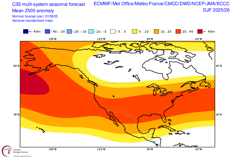
2025-2026 ENSO
40/70 Benchmark replied to 40/70 Benchmark's topic in Weather Forecasting and Discussion
Yea, this is precisely what I thought of. I think they are in error this time, but we shall see. CFS and CANSIPS are relatively cold. -
evil, evil tree
-
It all went to Virginia.
-
Yeah, still too early to know if it’s just a default or the models are onto something.
-
That’s one of the reasons I’m less sure of a total dreg outcome right now than I was heading into our last cold neutral/weak Nina/ horrific PDO winters, but keep in mind 2014 was the most extreme outcome of all similar analogs. Even if we got another 2014 “type” winter it would be extremely unlikely to result in that much snow. That was an anomaly. Also, we’re not arriving at the warm pool through the same larger scale mechanism this time as @Bob Chill pointed out and that matters. SSTs can be just as much an effect as a cause.
-
Do any of you guys have experience/tips with the wxprediction.com subseasonal forecast contest?
-
2025-2026 ENSO
40/70 Benchmark replied to 40/70 Benchmark's topic in Weather Forecasting and Discussion
So essentially seasonals defaulting to the prevalent regime of the past decade. -

September 2025 OBS-Discussion centered NYC subforum
bluewave replied to wdrag's topic in New York City Metro
Top 10 driest September to September period for many stations in the Northeast.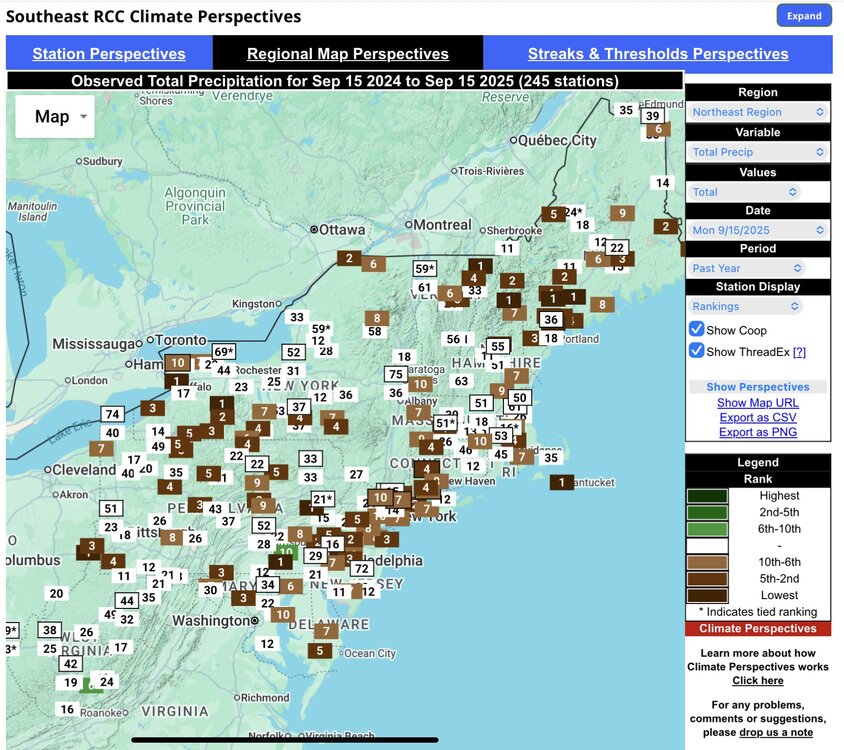
-

2025 Atlantic Hurricane Season
WxWatcher007 replied to BarryStantonGBP's topic in Tropical Headquarters
The whole hemisphere…that’s really where it gets crazy. -
That is the trend which is independent of the different regimes. It could be why the seasonal models are defaulting to it. I am not really interested in what the seasonal models are showing this early.
-
In Camp Hill I've had 0.73" in 58 days. Significantly less than the airport which is close to 4" or above. Since 1888 the records two months lowest preceiptitation total for Harrisburg official station was 0.88" during June and July in the insanely hot summer of 1966 where in those two months we hit 90 or above 40 times and 100 or above 7 times. The current drought, although not significant for the wider region this has certainly been significant locally due to it continuing and amplifying the trend of missing everything pop up starting in June. Further for the drought happening with below normal temperature in August. Sent from my SM-G970U1 using Tapatalk
-
2025-2026 ENSO
40/70 Benchmark replied to 40/70 Benchmark's topic in Weather Forecasting and Discussion
I'm not sure what you are saying here....Models favor Pacific trough? I think they are wrong on that. -
Thunder
-
1.24" of much needed rain down here around Fredericksburg with a mist fest ongoing. 59/57
-
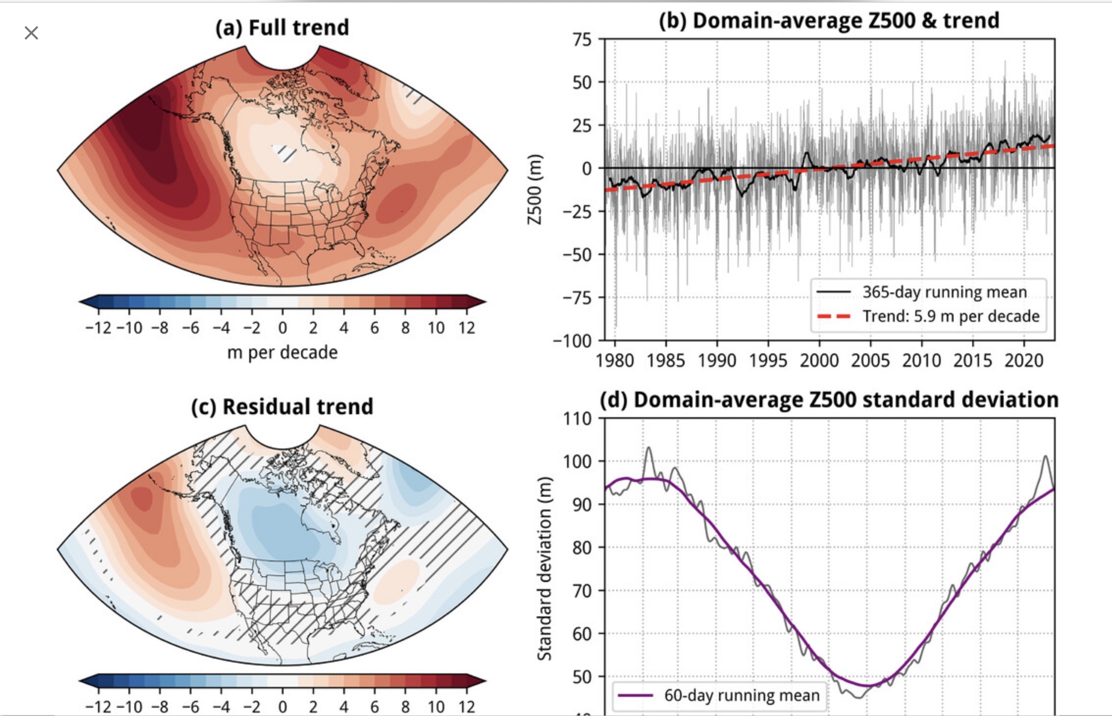
The blended model ensemble mean is defaulting to the full trend diagram.

-
We have become a region of moisture farmers... just like Uncle Owen and Aunt Beru back on Tatooine
-

September 2025 OBS-Discussion centered NYC subforum
jm1220 replied to wdrag's topic in New York City Metro
Looks like this low just vertically stacked so it's spinning/raining itself out. -
You can see the low starting to pull out https://www.star.nesdis.noaa.gov/GOES/sector_band.php?sat=G19§or=ne&band=09&length=24
-
And the oranges are monsoon level lol. 2” might be in sight for some locations around here.
-

September 2025 OBS-Discussion centered NYC subforum
doncat replied to wdrag's topic in New York City Metro
Not including this month yet but since last September, 5 months have had under 2" of rain here. 12 month precip totals getting down into the upper 20's inch range. -
2025-2026 ENSO
40/70 Benchmark replied to 40/70 Benchmark's topic in Weather Forecasting and Discussion
Looks to be an Alaskan Ridge season to me. -
You know it’s a decent event when even under the mild radar returns, it’s a steady rain. Over an inch now.
-
Total ripoff here too lol. Just enough to make the dust damp. Not nearly enough to do any good. It's pretty comical driving the gravel roads. Mile long smoke screens make me laugh . Reminds me of the old video game Spy Hunter
-
Just had my lawn seeded, it's covered in straw, need to get it all wet but noticed what you just said, best time to grow a lawn.
- Today
-
About 20 years ago, a group of four of us went in on a contractor grade aerator. It was a great purchase as it’s been very reliable even though the group of four has somehow expanded to about 8 now. Weird how that happens. But I’ll be aerating tomorrow too.
.thumb.jpg.ad3a2e31d30aff035044689b311a0540.jpg)


.thumb.jpeg.406ecda2eec9e267302c22b9f128fe3c.jpeg)