All Activity
- Past hour
-
 Yeah, delay usually means denied unless there's a northern stream heading down to deliver a fresh dump of cold. But since it's all we've got at this point, we give up our seats on the lifeboat and wait on board the Titanic for the Carpathia to arrive.
 -

Feb 10-11 Mid Week Minor Event - Ride the hot hand?
Baroclinic Zone replied to HoarfrostHubb's topic in New England
One wildcard is the potential for secondary SLP development along the south coast. This enhances the WAA bumping up QPF. - Yesterday
-
Canadian would be the best solution for most… was very close to all snow for nyc Long Island as well… front end to rain
-
Wow.. GFS' starting to look like Feb 2020 ...
-

Feb 10-11 Mid Week Minor Event - Ride the hot hand?
Damage In Tolland replied to HoarfrostHubb's topic in New England
That may be the entire region -
Don't know what the fuck your trolling ass is looking at. These are in Celsius
.png.69200ef21df57089eb33f9021da3d9c3.png)
.png.66cd7f039fe600dda84f10702fe2c22e.png)
.png.8adbde9a3883820daed680ff70751ba3.png)
.png.427b5cdec751ebe43f05e4c6c6747d5a.png)
.thumb.png.ef9e48c33aadb2d3535d064150cf765c.png)
-

Feb 10-11 Mid Week Minor Event - Ride the hot hand?
ineedsnow replied to HoarfrostHubb's topic in New England
2 to 4 looks good for here -
Heather liked Bobby Bobolinski.
-
no they aren't
-

February 2026 OBS & Discussion
donsutherland1 replied to Stormlover74's topic in New York City Metro
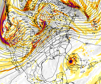
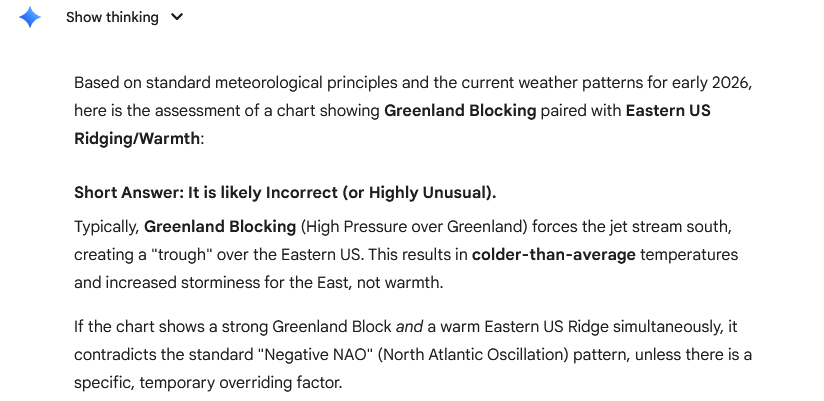
That's incorrect. The opposite is true. Winter/early spring is cold; it flips later spring/summer. Here are 500 mb anomalies and temperature anomalies for March Greenland blocks: Here are mean temperatures for NYC (1980-2025): March 1-15: NAO -0.50 or below: 39.3°; NAO +0.50 or above: 41.5° March 16-31: NAO -0.50 or below: 43.3°; NAO +0.50 or above: 46.4° Finally, what does AI say about the posted map under discussion? Here's ChatGPT 5.2's response: Gemini's Output: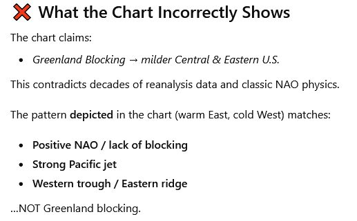
-
3 degrees? Lol enjoy your snow
-
Is we back? February discussion thread
Damage In Tolland replied to mahk_webstah's topic in New England
The machines may struggle with this particular event since they haven’t learned Archambault -
 Just takes too long to get precip into the region. GFS has been more delayed as well since yesterday. I haven't looked at other models that snow on us to see if they are earlier with onset.
 -
When are you installing?
-

February 2026 Medium/ Long Range Discussion: 150K Salary Needed to Post
CAPE replied to Weather Will's topic in Mid Atlantic
AI= Reliance on Historical data/much faster processing/better with resolving general patterns Physics based = Slower processing but superior wrt complex, small scale details/unusual weather events Just my take from what I have read. Personally, I rely on NWP/physics based models over AI. When I want granular details, NWP is where its at. -

February 2026 Medium/ Long Range Discussion: 150K Salary Needed to Post
Ji replied to Weather Will's topic in Mid Atlantic
still too early to give up on----i would wait till wednesdsay -
At least one positive, the Ai has the clipper for the 20th that the 12z euro had. Then again, this point of the season it’s big dog or nothing for me lol
-
and then you have to consider the strong LP along the mid- atlantic coast shown on the 12Z Canadian - lets see if the Canadian shows that at 0Z
-
18z Euro a little cooler than 12z with slp a bit further south and slightly weaker.
-
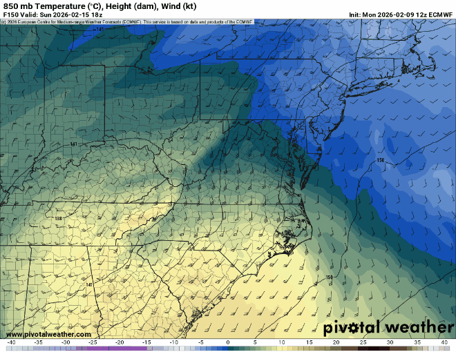
 Now there's how the MA does February. Enough of these Manitoba temps
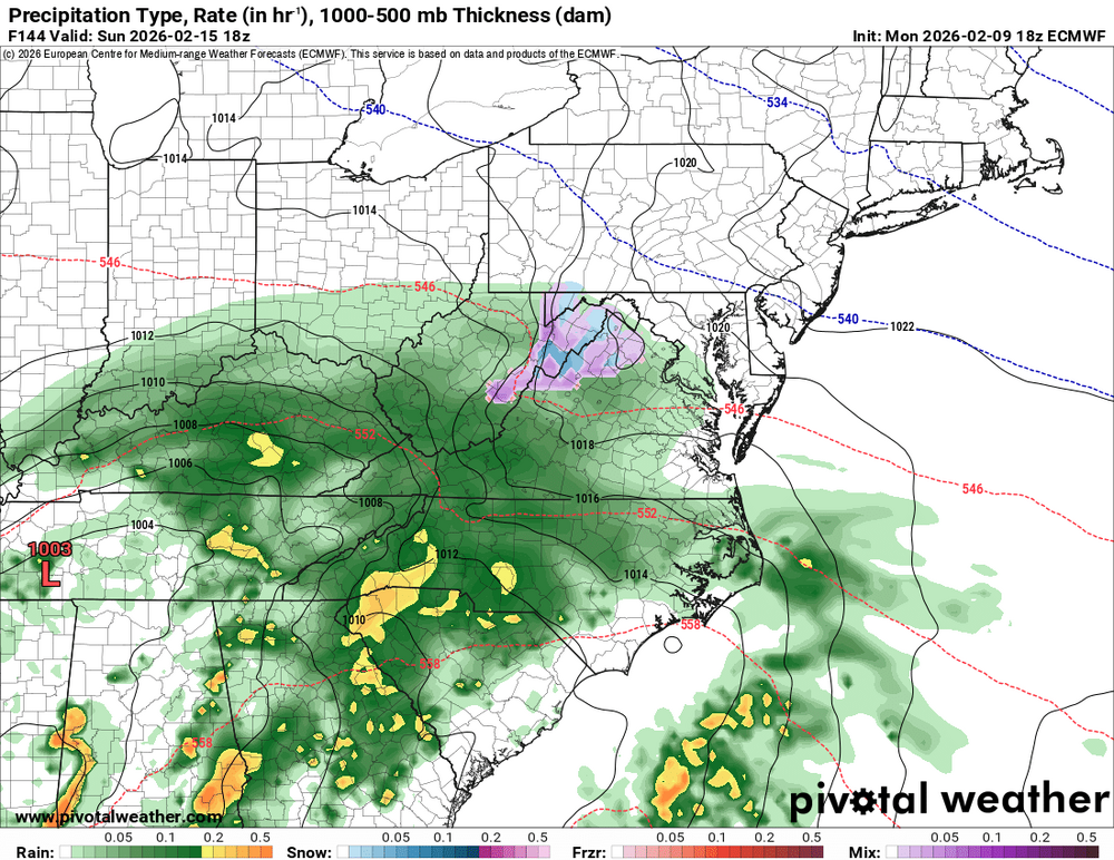
-
Weeklies are snowy with bn temps.
-
Record warm SST anomalies in the North Pacific, including year after year of marine heatwaves, continue to push a fast northern stream which is why it's been impossible to get a traditional, benchmark KU storm aside from 2021 and 2022 (for part of our forum). Until we see some sort of decline in North Pacific SSTs, this problem will continue.
-
its ensemble has consistently been farther north FWIW
-
18z euro OP would have went the way of the Ai, there’s no northern stream influence to help scoop it N. Without that it’s just a shortwave meandering underneath the ridge and it’ll glide ESE like the Ai models now showing.
-
I think the reason why the record warm west is getting so much attention is because the eastern half of the US has seen cold like this before. I mean, aside from a few record lows over the past few weeks on random days, nothing about the cold air has been unprecedented. Unusual, strong, and brutal yes. Record-breaking? No. But the fact that the plains and further west have almost 0 snow and have been running around 20 degrees above average since late November is excruciatingly rare and thus, record breaking. And as the world continues to warm, the warmest anomalies almost always outpace the colder anomalies. This winter is a great example of that


.png.3876ddec2bf7359340aeae900f8e3f9f.png)


