All Activity
- Past hour
-
These complexes can be very frustrating!! Countless times I have watched radar thinking there is no way this is going to miss and 10-15 minutes later, it is like some secret power has blocked your backyard from getting anything fun!! Joe Lundberg from Accuweather kindly spent some time educating me (like 20 years ago back when JB and Ken Reeves were all there) about LLJ dynamics and thermal and energy impacts on these complexes. It really helped me and I fully understand what is happening but still amazes me when a massive red blob 15 miles or so on radar can be heading right for you and you get nothing!!
-
Also the occasional chipmunk! Did note 14,000 outages in MA and scattered reports across eastern NY and Northern New England... Bottom line is the New England region has an aging dense hardwood tree canopy with an abundance of diseased and previous damaged trees! We need either a derecho or CAT 3 to clean house...
-
Scott's right in that assessment ... it's a warmer than normal mid latitude continent synoptic and super synoptic ( tendency...) through 300+ hours. The GFS actually rolls big heat back in by next Saturday, and I'm not completely sold on the idea that Thur and Frid will really turn out that corrected. Even if so, it transient and would likely yield the bigger signal with at least episodic heat returns. GGEM is essentially the same.
-
Also the occasional chipmunk! Did note 14,000 outages in MA and scattered reports across eastern NY and Northern New England... Bottom line is the New England region has an aging dense hardwood tree canopy with an abundance of diseased and previous damaged trees! We need either a derecho or CAT 3 to clean house...
-
Go up to Gaspesie National Park, Forillon National Park and Percé next time. A million times better than Maine.
-

E PA/NJ/DE Summer 2025 Obs/Discussion
RedSky replied to Hurricane Agnes's topic in Philadelphia Region
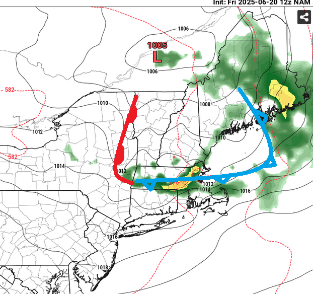
Don't remember the last time I saw this alert three days early URGENT - WEATHER MESSAGE National Weather Service Mount Holly NJ 212 AM EDT Fri Jun 20 2025 PAZ060>062-070-071-101>106-201915- /O.NEW.KPHI.XH.A.0001.250623T1200Z-250626T0000Z/ Berks-Lehigh-Northampton-Delaware-Philadelphia-Western Chester- Eastern Chester-Western Montgomery-Eastern Montgomery-Upper Bucks- Lower Bucks- Including the cities of Honey Brook, Lansdale, Allentown, Collegeville, Pottstown, Bethlehem, Easton, Chalfont, West Chester, Morrisville, Oxford, Doylestown, Reading, Kennett Square, Perkasie, Norristown, Philadelphia, and Media 212 AM EDT Fri Jun 20 2025 ...EXTREME HEAT WATCH IN EFFECT FROM MONDAY MORNING THROUGH WEDNESDAY EVENING... * WHAT...Dangerously hot conditions with heat index values up to 107 possible. * WHERE...Portions of east central and southeast Pennsylvania. * WHEN...From Monday morning through Wednesday evening. * IMPACTS...Heat related illnesses increase significantly during extreme heat and high humidity events. * ADDITIONAL DETAILS...Low temperatures will hover near 80 degrees in urban areas. Heat will have a cumulative effect on the body as the week goes on as little relief will come overnight. -
These models are actually responding to the rapidity of the ridge burst in the larger synoptic sense. The MCS zygote is already skirting E through the NP Saturday but then it moves into a favorable differential thickness packing where the ridge/heat suddenly expands NE... It's possible the CIN shuts the door in NE while the NAM is still "sort of" right about the outflow boundary.. I could see that being a burst of wind and a coughing shelf cloud field that doesn't have anything aft of it. So sort of mid way between the global and meso idea -
-
 weathereric joined the community
 -
It's extremely intriguing. These type of setups are absolutely brutal to forecast in the northern Plains/upper-Midwest (where I think they are "most common") so imagine how much of a pain for us. Obviously there is going to be a hell of a cap in place plus we will have heights rising...but this could be offset a bit in a NAM solution. But this is something where if you're just looking at QPF alone...you could totally miss/disregard any convective potential and all of a sudden inside 12 hours mesos start going wild.
-
Congrats Maine.
-
yes ...it does, whenever in the winter the Euro's given the base a dopamine jolt and the gfs' shittin' in punch bowl blows the Euro out of the water
-
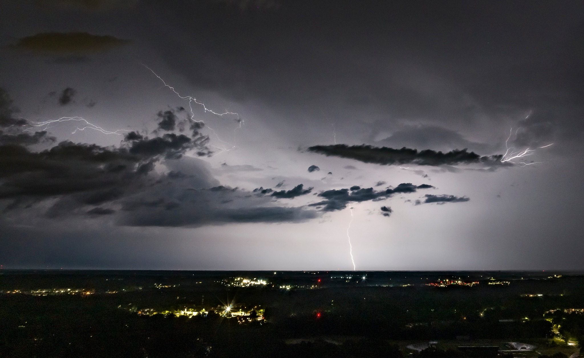
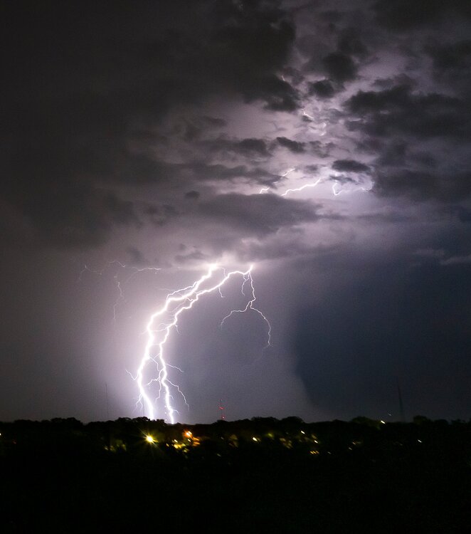
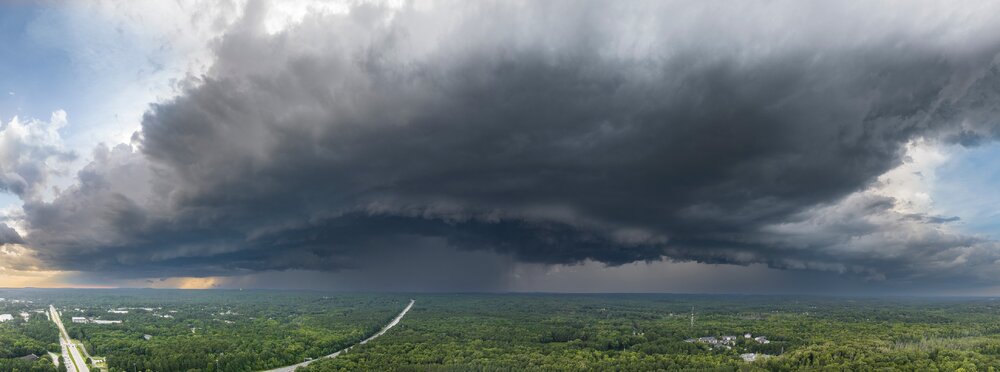
Yesterday's action:

-
I thought toys would be worse but it’s quite nice out. 77 at 12:45 with a 10 mile breeze that is refreshing.
-
Good call. My lawn gets mowed tonight.
-
NAM is fascinating .. it's doing a classic plains outflow boundary severe response on the trailing edge of a derecho outflow boundary at 11am Sunday, then... rolls that mess out in time for big heat numbers by 20z later that afternoon.... Below is 11am... by 4pm, it's 90+ with no trace of this and west wind everywhere. GFS does not have this ... ends up 95 to 99
-
I thought the GFS was schooling the Euro as some thought?
-
On a different topic are we going to get a big northern lights display from this? https://www.newsweek.com/nasa-satellite-extreme-solar-flare-us-states-blackout-map-2088388 Large parts of the United States faced a radio blackout on Thursday following a strong solar flare from the sun. The "extreme ultraviolet flash" was captured by NASA's Solar Dynamics Observatory satellite. The solar flare, categorized as X-class in scale—the highest scale, was triggered by an active region of a sunspot on June 19 at 11:50 p.m. UTC. Radiation from the X1.9 blast caused a shortwave radio blackout over the Pacific Ocean, leading to a loss of signal at frequencies below 25 Megahertz (MHz). Amateur radio operators, especially in Hawaii, may have noticed the signal loss. Solar flares are intense bursts of radiation from the sun. The most powerful explosions in the solar system, they can can contain as much energy as a billion hydrogen bombs, according to NASA. Solar flares are classified according to their intensity, with X being the highest on the scale. X-class solar flares can cause planet-wide radio blackouts and long-lasting radiation storms.
-
So is the MCS on or off ?
-
wow what the heck was going on in 1949 lol, was that the 1940s version of 2010? I wonder if JFK had many 100 degree days that summer, I know they had three in a row in 1948. Come to think of it, 1948 and 1949 sound a lot like 2010 and 2011....
-
Prepare to have your tastebuds slabbed.
-
to be fair EWR was also hotter than NYC before the foliage problem happened (I'm referring to 1988, 1991 and 1993). But we can use just EWR data if you prefer. Just going by EWR data, 1949 and 1993 have the most 100+ days It makes me think we need lower heights to reach triple digits back then than what we need now (because of more moisture in the air now.)
-
 CAPE changed their profile photo
 -
this is exciting as the two models taking turns forecasting a 30 inch snowstorm for us vs 3 inches of rain lol
-
Sunday has to be watched closely though. Either with MCS timing or if the MCS is north any outflow acts as a boundary but that is about as volatile of an airmass you'll see here with tremendous shear.
-
The question though is, at least for our part of the country, do we need a stronger 500mb ridge to achieve 100 degrees than we needed in, for example, 1944 or 1948 or 1949 or 1953 or 1955 or 1993?
-
yes and weighing them relative to each other is also important (as is sometimes applying them to one part of the season vs another.)
-
For any FFA alums out there, you likely recall the Blue Corduroy jackets. Next week is the state convention for FFA in Raleigh. Imagine 102 in a corduroy jacket walking the streets looking for a hotdog vendor.