All Activity
- Past hour
-

“Cory’s in NYC! Let’s HECS!” Feb. 22-24 Disco
WinterWolf replied to TheSnowman's topic in New England
We are the same age…78 is very vivid for me too. That was the benchmark here. But Feb 2013 delivered even more snow…so they are both the most impactful winter storms here now. Let’s see if this beast can match up to those two for my area. -
We may have one or 2 more shots/threats looking at this Euro 6z 144hr so long as that cold pool in Canada can push far enough south. Decent blocking over the Pole.
.thumb.png.472304e5af960de1386f582e89763726.png)
-
Many news outlets said snow. I heard them. They are still saying it. Mt holly said rain possible, but the public doesn’t read the nws discussions. Cut people some slack. Even yesterday people right here were saying snow by 8 am, despite temps being in the high 30s.
-
Every storm people panic day of. It's like clockwork. Oh it's starting as rain, oh it's too warm, oh it's too dry, amounts are too light, models are ticking east/west, it's not snowing yet, etc. And 90 percent of the time it's nonsense and means nothing.
-
36 degrees here with an east wind gusting to 20mph. light rain. I am expecting about 18 inches here and wind gusts at my house between 45 and 50. Anything more will be an over achiever.
-

Blizzard of 2026 Storm Thread/OBS
BroadWing3544 replied to Mikeymac5306's topic in Philadelphia Region
Morning folks. Gray and misty here in SEPA, just about ten minutes north of Wilmington. Temp hovering around 33-34*. Careful out there today, all! -
I definitely agree with that. I don’t see widespread 2 feet amounts but I’m sure there will be quite a few. His claim was baseless earlier. I think we land somewhere in the middle between the NAM/SREF and rest
-
-

Feb 22nd/23rd "There's no way..." Obs Thread
300 square feet replied to Maestrobjwa's topic in Mid Atlantic
An occasional sleet pellet mixed in with the rain here in Reston. 36/35. -

Feb 22nd/23rd "There's no way..." Obs Thread
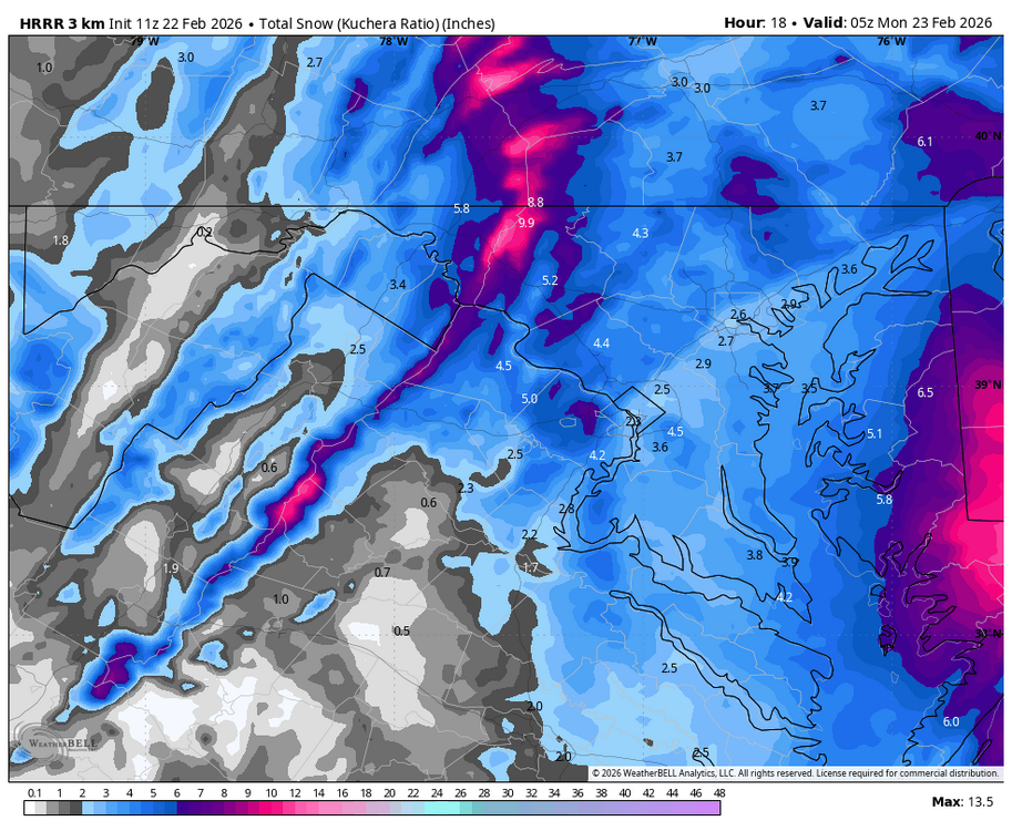
Weather Will replied to Maestrobjwa's topic in Mid Atlantic
WB 11Z HRRR statewide and zoomed. Note west of Bay it is just light snow by end of run at midnight.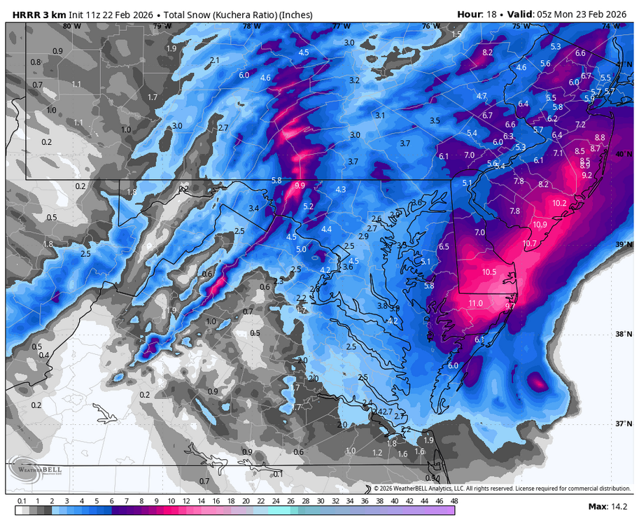
-
I wonder what element of this is missing from the forecast. Most impacted area. Amounts, highest winds...duration? There is always something that is under/over predicted. Just like a fingerprint or a snowflake no two are the same.
-
light snow here in huntington, long island
-
Looking at my ring live view looks like snowing now in fair lawn NJ.
-
Well, radar certainly looks much better 6 hours later. Let’s go
-

Blizzard of 2026 Storm Thread/OBS
Ej257 snow lover replied to Mikeymac5306's topic in Philadelphia Region
Light snow in Nazareth, Pa since 7am. Starting to see it stick to the grass -
Snow Montvale nj. Not sticking yet .
-

Feb 22nd/23rd "There's no way..." Obs Thread
mitchnick replied to Maestrobjwa's topic in Mid Atlantic
You should be seeing the random flakes that have become not so random anymore. -
I assure you there will be no violence involved. Just started snowing ever so lightly. And so it begins.
-

Feb 22nd/23rd "There's no way..." Obs Thread
PrinceFrederickWx replied to Maestrobjwa's topic in Mid Atlantic
No snow yet. I had 0.02” in the Cocorahs gauge this morning, and everything is still damp, but it’s currently just cloudy. -
I think he is just trying to make the point that there is a large difference between the max NAM/SREF amounts and most everything else. The RGEM is not a trash model. Give it a chance unfold and see where this is going. Me personally I don’t think we see 24”+ amounts with this but I also believe RGEM amounts are on the low side.
-
“Cory’s in NYC! Let’s HECS!” Feb. 22-24 Disco
WinterWolf replied to TheSnowman's topic in New England
We tried to tell ‘em…. But I think some of that was about the extreme cold. But now we shift focus to extreme snowfall….winter 25-26 stepping it up further. -

"Don’t do it" 2026 Blizzard obs, updates and pictures.
The 4 Seasons replied to Ginx snewx's topic in New England
i feel you and I'm just having a discussion because I'm curious how people feel about this. I consider it all part of the "storm" from 500 to the sfc so if the same thing happens on the back side a day later from the ULL energy swinging through I'd count that as well. On the flip side i would count this on the front end. For example Feb 1-3rd 2021, the main part of the storm ended around or just before midnight on the 1st but the ULL parked there for a couple days and we got scattered snow showers/squalls that produced additional snowfall and that was counted. SeymourSnow got an additional 1.5" ish nearly 24-36hrs after the main part ended and that pushed him from 16.5 up to 18. I feel like the COOP and climate sites would add it to the final storm total. It's just personal preference i guess. This is another factor that contributes to highly varying snow totals in large long duration storms, along with clearing every 6hrs or greater. I'm curious what @dendrite thinks about this, should you add this mornings light snow to the overall storm total? Looking at cocorahs there's some towns that reported a few tenths up to a half inch this morning at 7AM. -
Damn! Missing this one? Safe travels, man.
-

Blizzard of 2026 Storm Thread/OBS
Kevin Reilly replied to Mikeymac5306's topic in Philadelphia Region
https://radar.weather.gov/station/kdix/standard So is that rain or sleet just south of Dover creeping north? -
Yup not much going on here yet. Radar to SW looks nice, if it ever can get up here.
.png.f24dcdc96ddc2ba9cc5b2ee837758a63.png)


.thumb.png.991e09c19c25af7391ed569a205a5136.png)
