All Activity
- Past hour
-
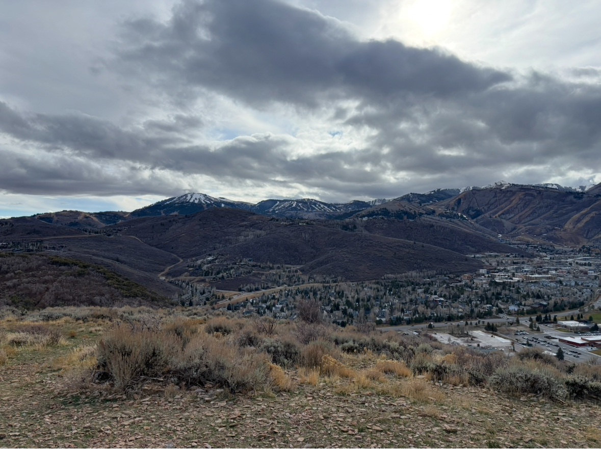
I was skiing at Belleayre on Friday and they are off to their best start in years. likewise, many resorts in the northeast. I was in Park city last week. They are off to a horrendous start . no snow at all and not open. that is what the Wasatch range looks like right now. Direct shot of Park City Mountain

-

2025-2026 ENSO
donsutherland1 replied to 40/70 Benchmark's topic in Weather Forecasting and Discussion
The 0z GEFS was showing on of the more uncommon December teleconnection combinations near the end of its forecast period.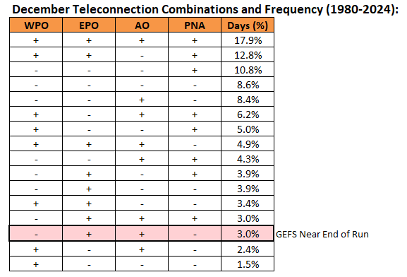
-
 I've been there, man....wonderful thing about the weather is it's always there waiting in the other side.
 -

November 2025 general discussions and probable topic derailings ...
jbenedet replied to Typhoon Tip's topic in New England
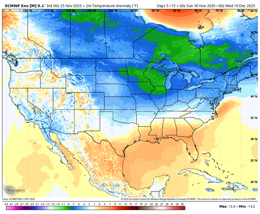
The first week of December is warming on guidance. MJO, teleconnections forecasts are all moving to warm phases. I don’t get the excitement at all. MJO phase 7 in November is actually N to cold but we are moving into December as we settle into that phase. I think this is leading to some false cold signals on guidance. Of course I’m speaking wrt where most of us live—close to the coast. The modeling showing more ridging in the SE and cold dumping over the central CONUS is much more in line with the tapestry of MJO phase 7 in December. -
Been preaching since last summer that se Canada will be cold this season, ignore the rest. All you need to know unless focused on a KU. There hasn't been a shred of doubt in my mind RE a cold se Canada.
-
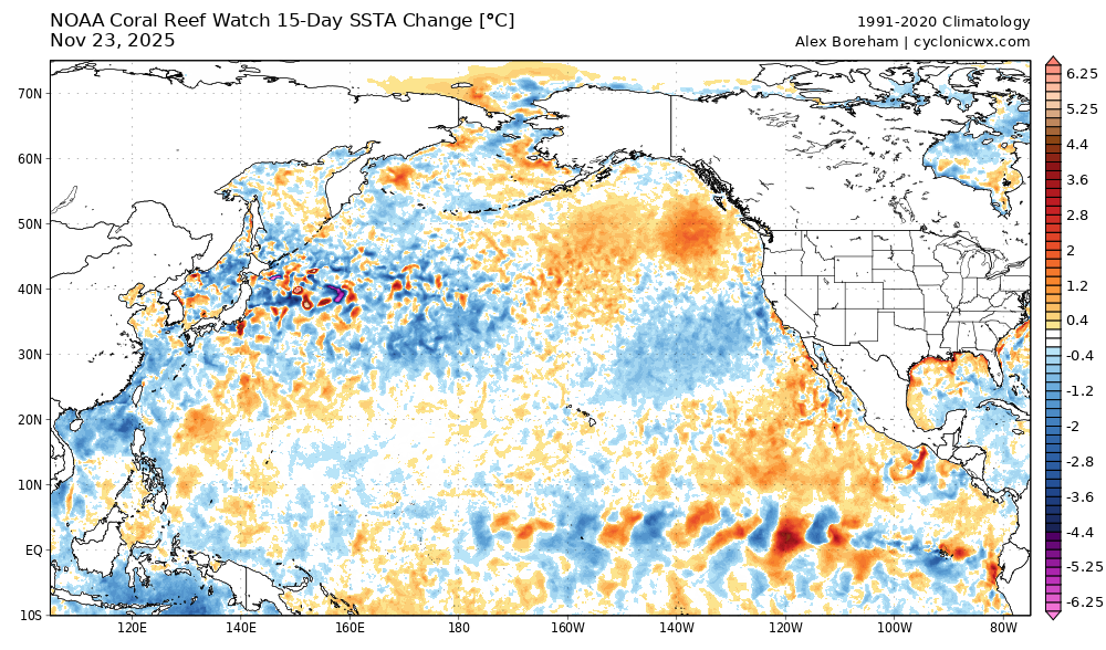
The return of the blob? Btw, thanks for posting the model forecast change loops. If you look to the left at the north pacific, notice the lines tightening meaning the models underestimate the pac jet and it gets stronger as it gets closer in time. That nudges north pac ridging to the north and east into the EPO domain, which means more cold for midwest and possibly the east. The SST change map also seems to reflect this tendency.
-
Get ready for something akin to December 2007 or 2008. It's going to be good month for most of us, just without the dumb SSW crack that social media was dealing.
-
Coldest week so far in this La Niña event in regions 3.4 and 4…
-

Nov 28-30th Post Turkey Day Wintry Potential
Baum replied to Chicago Storm's topic in Lakes/Ohio Valley
Cruel overnight runs sounds like. -
Same goes with every model in the long range. These models aren't stable at all.
-
First week of December on eps
-
 Caught it the last mile of my run. I’ve seen a lot over the years. Was a solid one
 -
And its gone on the models
-

November 2025 general discussions and probable topic derailings ...
ineedsnow replied to Typhoon Tip's topic in New England
Of course thicker clouds ruin it when i drive to find a good spot -

November 2025 general discussions and probable topic derailings ...
WinterWolf replied to Typhoon Tip's topic in New England
Is that you? -

MO/KS/AR/OK 2025-2026 Winter Discussion
stormdragonwx replied to stormdragonwx's topic in Central/Western States
Indeed NWS TSA is jumping on board. -
15 day change
-

December 2025 Short/Medium Range Forecast Thread
Holston_River_Rambler replied to John1122's topic in Tennessee Valley
I haven't started my WxBell or other subscriptions yet, but would be interested to see some of the individual members on GEFS and EPS for Dec 1 -3. Edit: -
December 2025 Short/Medium Range Forecast Thread
Holston_River_Rambler replied to John1122's topic in Tennessee Valley
Decent overnight runs with a front swinging through and a weak low forming around Dec 1-2. Room for a NW trend at this range. -
 Yeah, beautiful start
 -

December 2025 Short/Medium Range Forecast Thread
Carvers Gap replied to John1122's topic in Tennessee Valley
The 0z CMC has ice for the western half of the state and typical CAD locations of W NC. The 0z Euro is close to a storm. The 6z GFS is just cold which differed greatly from its 0z run - even just after 100h! The 0z Euro was one cold front after another. I do think the SER will flex between fronts. Could be some wild swings. Definitely plenty to look at from overnight. -
December 2025 regional war/obs/disco thread
Baroclinic Zone replied to Torch Tiger's topic in New England
So many players on the field. Models have that timeframe all over the place. Cutter to sheared out nothingness -

Central PA Fall Discussions and Obs
mahantango#1 replied to ChescoWx's topic in Upstate New York/Pennsylvania
-
I like to come back and engage right before Thanksgiving for great maps like this. .
-
November 2025 general discussions and probable topic derailings ...
ineedsnow replied to Typhoon Tip's topic in New England
Crazy pink sunrise right now if you got a good view east.. I was driving so didn't get a pic but looks awesome!