All Activity
- Past hour
-
Did I see right on the news this morning that Boston is running like -8” of rain this year?
-
Beware that late afternoon bounce though. East Boston is already near 90. It won’t take much more of a southwest push or enhancement from the South Coast seabreeze to get it close to that temp. Logan‘s always tricky in these set ups cause they can get a late bounce or they stay really stubborn stuck at lower temperatures.
-

Junorch obs and discussion 2026
CT Valley Snowman replied to Damage In Tolland's topic in New England
88 so far for a high. 87 currently. Hoping to hit 90. -
Agree in principle ... but, I'm noticing here about 30 MI into the interior we've flipped the BL, because we're doing WSW at more than just wobbling leaves. When it's been like this in the past with these sun grown mixing depths, sometimes we get a late W wind burst through the city and Logan'll kinda cheat a high off the urban fart between 6 and 7. May even be counter-intuitive but what's happening is that that the gradient, albeit weak, is mixing down when max heat gets to critical and the BL turns over. not every time but late highs are thing out there
-
It followed me to Omaha.
-
-
Hopefully some day we'll get something like that again.
-

Junorch obs and discussion 2026
Damage In Tolland replied to Damage In Tolland's topic in New England
Yeah ensembles all have a hot pattern middle next week on with 90’s again -
WxWiz wants a repeat of this! https://www.weather.gov/aly/derecho1995
-
Hopefully a ring of fire pattern soon
-
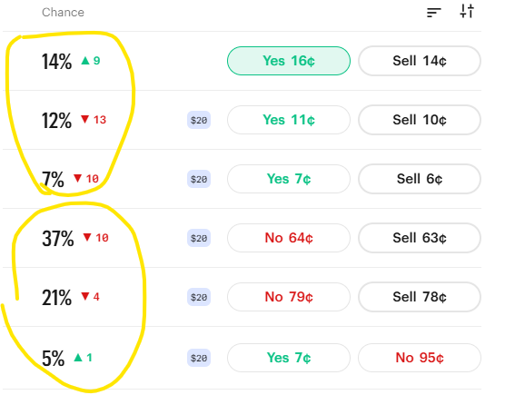
Good day for meteorologists on Kalshi! High has been stuck at 78-81 since ~10am due to the sea breeze. Winds are still out of the SSE at ~12mph w/several hours of daytime heating remaining. Despite that, lots of "bots" are bang'n highs of 88+. This is one of those situations where humans dominate bots... Anomalous, small-scale weather. You love to see it. Judging by the distribution, looks like 65% bots vs. 35% humans (predicting the max. temperature at KBOS). The bots are too caught up on the NWS gridded forecast (expected high of 89 as of this morning).
-

2026 Atlantic Hurricane Season
LakeNormanStormin replied to Stormchaserchuck1's topic in Tropical Headquarters
10/4/2 -
Late spring brush fire threat, especially after green up. 2 yesterday in Coventry and West Greenwich RI
-
 We are cooked
 -
00z Euro was trying to finish as a significant move toward what you describe. It also was warm run over all. In fact, I'm not seeing a lot of "cool" either. I think this summer's sort of pattern dictated at this point. Like we'll be shifting between 65 and 90 and not 40fuckum7 and 65
-
As May 2026 expired while we were in SNJ, I'll put its history here. Some data are averages from nearby sites, though the 31 on 5/31 is a certainty. Avg max: 63.9 0.8 BN Warmest was 86, on the 19th. Avg min: 39.2 0.8 BN Coolest was 26, on the 4th and 9th. Mean: 51.6 0.8 BN As both March and April were AN, met spring averaged 0.7 AN. Precip: 4.17" 0.20" AN. Wettest day; 1.40" on the 15th. May 2025 was also AN, but the 10 of the 11 months thru last April were BN. Nothing out of the ordinary this May. The 2nd and the 2nd from last were windy and cold (2nd had some IP as well) but beyond those 2 days, little was particularly memorable.
-

2026-2027 Strong/Super El Nino
PhiEaglesfan712 replied to Stormchaserchuck1's topic in Weather Forecasting and Discussion
I saw this Early 2026-2027 Snowfall Insight on LinkedIn: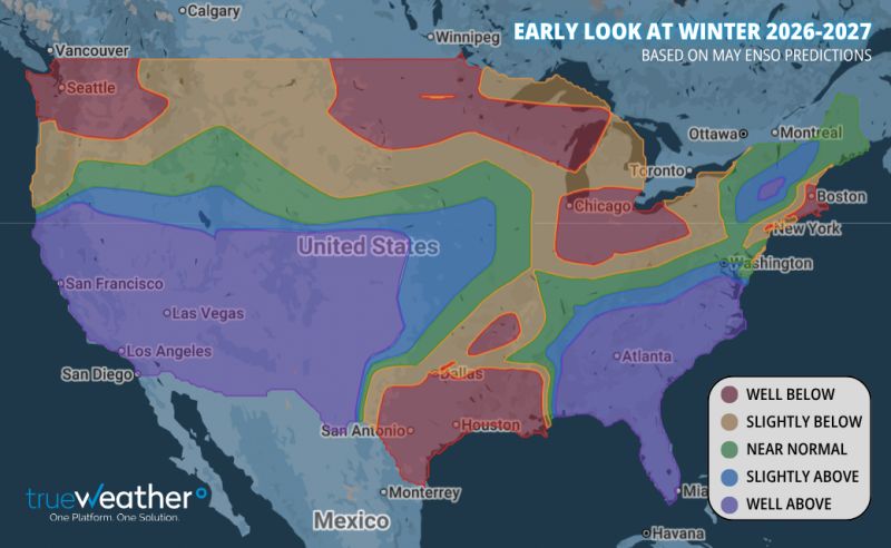
-
Hager did a good job taking over all things considered but when I think VH it's Diamond Dave. I had the VH symbol (and Zeppelin) symbols all over my note/copy books for grade school. Goes w/o saying the nuns didn't dig it...


- Today
-
Those 3 1954 storms all had names of my relatives - cousin, aunt, great aunt chronological. Carol was nothing I can remember, probably some rain at our NNJ home. Edna was mostly dry. We flew kites in its breezes. Hazel had wind in NNJ comparable to Bob in central Maine, dumping some trees and plastering our home with pieces of tough October leaves.
-
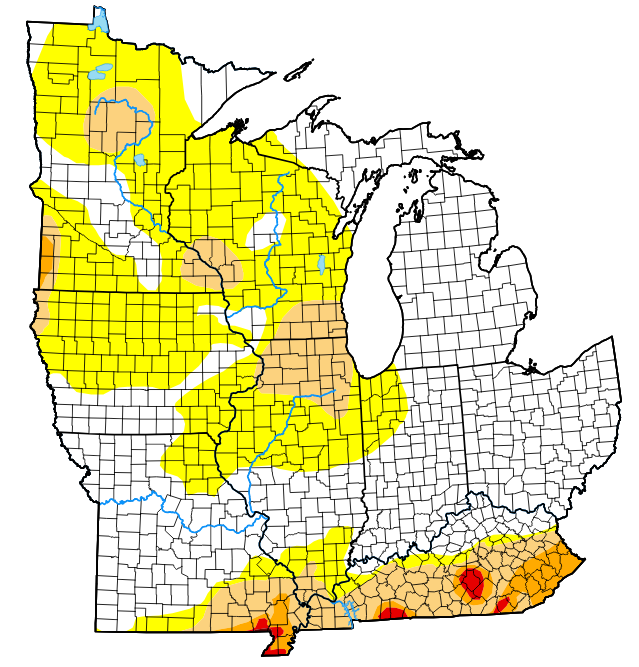
Pretty big jump in the D0 category this week.
-
The ensembles get rid of that propensity and start to retro a trough a bit to the GL. I think second half of month turns a corner, and not just because of climo.
-
DPs low but it's hot... 89 ... that's about the cut-off where lower DP no longer saves... Hot day
-

2026-2027 Strong/Super El Nino
mitchnick replied to Stormchaserchuck1's topic in Weather Forecasting and Discussion
Yep. And if you scroll thru the slp maps for each month, you can easily imagine at least one good hit down your way. January, and especially February, even show cold air/ridging pressing south along the Appalachians starting in Virginia. Here's a link to December: https://www.tropicaltidbits.com/analysis/models/?model=cfs-mon®ion=us&pkg=mslpa&runtime=2026060406&fh=6 -
Sat looking good. WxWiz needs the the tstm "hit!" And then Scott "Ossipee" hailers moving N-S on Sun. Can't get rid of these cold 500 troughs rotating through and the blocking. If the 00z ECMWF is correct, after Sat, no sig heat or dew point (gin and) juice UFN for eastern sections.
-

2026-2027 Strong/Super El Nino
GaWx replied to Stormchaserchuck1's topic in Weather Forecasting and Discussion
Winter storns in the South outside of the mountains are for the most part somewhat freaky events. Thus, due to the low frequency, our snowiest or iciest winters are often from mainly just one major (or series of) winter storms at most. Examples: late Jan of 1940, Feb of 1952, mid Feb of 1958, 12/31/1963, 2/9-10/1973, 3/1-2/1980, 3/24/1983, late Jan of 1987, 1/7-8/1988, mid Jan of 1992, the ice storm of late Jan 2005, and Dec of 2018. All of these were during El Niño and these were enough to make them wintry. So, El Nino’s on average produce for wintry precip despite often being Mei Lu from just one storm on the right track (usually Gulf to off SE Coast) at the right time (when cold enough air to the N/NW being tapped into enough).


.thumb.gif.f92b16c631a1d15d405ed77b33f0710d.gif)


