All Activity
- Past hour
-
Flurries in Havre de Grace
-
What year did it tie ? Thanks
-
Pretty heavy snow in York right now .
-

Central PA Winter 25/26 Discussion and Obs
CarlislePaWx replied to MAG5035's topic in Upstate New York/Pennsylvania
At 5:20pm it continues to snow lightly, but no longer accumulating. Just mood flakes...except I can't see them anymore...lol. I measured 0.8" in total new snow. Temperature has leveled off at 19.8 degrees. I love how crystalline the new snow is when it falls at these cold temperatures. My flashlight was reflecting back from the snow. I'll go melt the snow down once it has 100% ended. Perhaps it will be upwards of 15:1? We'll see. -
BWI tied record low max of 26
-

Central PA Winter 25/26 Discussion and Obs
canderson replied to MAG5035's topic in Upstate New York/Pennsylvania
Slowing to pixie dust so might be on the edge. What a fun surprise. Now for a drive … -

Central PA Winter 25/26 Discussion and Obs
Itstrainingtime replied to MAG5035's topic in Upstate New York/Pennsylvania
It's beautiful out...although it could not have come at a worst time for rush hour traffic. -
-

December 2025 regional war/obs/disco thread
Ginx snewx replied to Torch Tiger's topic in New England
Alberta Clippers -
Central PA Winter 25/26 Discussion and Obs
canderson replied to MAG5035's topic in Upstate New York/Pennsylvania
.5 “ it appears and still snowing -

Central PA Winter 25/26 Discussion and Obs
Ruin replied to MAG5035's topic in Upstate New York/Pennsylvania
Well, that's what i'm saying.It's like I say, how inaccurate things are.And I get harp going for it, I don't want to be wrong, but we can't even rely on a forecast for the next day.Or for this day today, they mentioned nothing about any local forecasts.Maybe a model picked up on it, but none of the weather forecasters actually pointed that out -

Central PA Winter 25/26 Discussion and Obs
WX-PA replied to MAG5035's topic in Upstate New York/Pennsylvania
Snow here..came out of nowhere..And you guys worry about 10 day forecasts lol..when they can't even get tomorrow right -
Truly a horrid place for snow
-
Well realistically speaking what are the odds that December is as cold as it is and January/February don’t torch. It’s hard to get a few colder than average months in a row these days
-
Interesting stats. I think what saved 2016-17 was the +PDO and the Nino “hangover”. Had the PDO been negative that winter, I think the results may have been different….just my opinion. It was also almost a 2nd year El Niño….the strong -IOD caused the La Niña to develop, had it not been for that, I have no doubt that would have been a double dip El Niño
-

Central PA Winter 25/26 Discussion and Obs
Jns2183 replied to MAG5035's topic in Upstate New York/Pennsylvania
Beautiful little band Sent from my SM-S731U using Tapatalk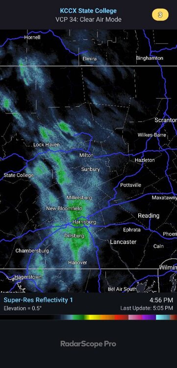
-
That was a strong El Nino that faded into a weak La Nina.
-
Cold hi of 16.9 today. Remained mostly cloudy but no flakes.
-
I doubt that with the dying La Nina.
-
Central PA Winter 25/26 Discussion and Obs
Ruin replied to MAG5035's topic in Upstate New York/Pennsylvania
Same lol -
Central PA Winter 25/26 Discussion and Obs
Ruin replied to MAG5035's topic in Upstate New York/Pennsylvania
Same tenp went from 26 to 22 with the snow coming down -
Central PA Winter 25/26 Discussion and Obs
Ruin replied to MAG5035's topic in Upstate New York/Pennsylvania
Lol just watched online vid abc 27 mo real accumulation just snow showers -

December 2025 regional war/obs/disco thread
Damage In Tolland replied to Torch Tiger's topic in New England
The 25th into the 26th looks like the timeframe with the energy sliding in from the Pacific. Probably a SWFE -
Do coastals ever happen with a look like that? I can't imagine how.
-
Fingers crossed CAR has the right idea in their AFD Rainfall amounts of one half to one inch are most likely, with a small chance of local amounts to around 1.5 inches. Significant snowpack loss is expected Downeast, with less snowpack loss and more compaction for central and northern areas. The snowpack will absorb most of the rainfall, so flooding is not a significant concern. The low level jet will also produce strong to possibly damaging winds, especially along the coast. Further inland, cold snowpack should act to strengthen the surface inversion and limit mixing towards the surface.


.thumb.JPG.418e8a9a2902ae687ec35ff4bc0e038e.JPG)


