All Activity
- Past hour
-
I’m going to go with 3.2” as well, which is what the wife measured at noon. I’m sure it was higher but I can’t verify that, melted to .23 although that includes some drizzle this afternoon.
-

December 2025 regional war/obs/disco thread
Typhoon Tip replied to Torch Tiger's topic in New England
Pistol to head? this January will be very close to:
-

White Christmas Miracle? December 23-24th
moneypitmike replied to Baroclinic Zone's topic in New England
Things whitened up quickly.....had a burst of moderate snow with great flakes. Short-lived and now down to steady inefficient ones. At least we dipped below freezing. 31.6* -
.thumb.png.4150b06c63a21f61052e47a612bf1818.png)
White Christmas Miracle? December 23-24th
HIPPYVALLEY replied to Baroclinic Zone's topic in New England
Oh good, now it’s raining! -
Turns out a couple of storms from midnight tonight through Friday night may dump upwards of 4 to 7 FEET of fresh snow all up and down the Sierra! We shall see.
-
I might even whiff if the models dont stop trending south.
-

December 2025 regional war/obs/disco thread
40/70 Benchmark replied to Torch Tiger's topic in New England
Same result, though...still got the lagged NAO. -
I think he likes the warm weather that's why his picture is a heat mizer lol
-

White Christmas Miracle? December 23-24th
CoastalWx replied to Baroclinic Zone's topic in New England
34.5 could flake better if we had rates -
2025-2026 ENSO
40/70 Benchmark replied to 40/70 Benchmark's topic in Weather Forecasting and Discussion
Irony is I specifically made a note of your lag periods last off season, and then got the opportunity to practice it, and didn't. lol Do you still use it even if there is no reversal? -

White Christmas Miracle? December 23-24th
powderfreak replied to Baroclinic Zone's topic in New England
Surprisingly good snow growth so far. Somewhere between 1” and 2” so far and a nice looking band about to move in.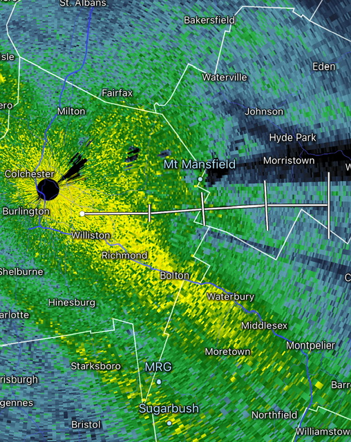
-

December 2025 regional war/obs/disco thread
DavisStraight replied to Torch Tiger's topic in New England
Rather a whiff than rain. -

2025-2026 ENSO
Stormchaserchuck1 replied to 40/70 Benchmark's topic in Weather Forecasting and Discussion
Live and learn. I love techniques that have that kind of a lag time (>+20 days).. It should be noted that Stratosphere cooling events do not have a lag. They correlated with +AO at Day-0. This is for all times of the cold season. -

E PA/NJ/DE Winter 2025-26 Obs/Discussion
Mikeymac5306 replied to LVblizzard's topic in Philadelphia Region
Thread started. Figured it was safe to get one started as NAM is now in range. -
December 2025 regional war/obs/disco thread
Typhoon Tip replied to Torch Tiger's topic in New England
right, not an SSW -
2025-2026 ENSO
40/70 Benchmark replied to 40/70 Benchmark's topic in Weather Forecasting and Discussion
Yea, typo. -

White Christmas Miracle? December 23-24th
Chrisrotary12 replied to Baroclinic Zone's topic in New England
Which shade of grey/blue are you upset about? -
Safe to get this started as NAM is in range and 18Z GFS rolling. Happy Tracking!
-
A wennie's got to do what a weenie's got to do! Lol
-
2025-2026 ENSO
Stormchaserchuck1 replied to 40/70 Benchmark's topic in Weather Forecasting and Discussion
You mean -NAO/-PNA, +NAO/+PNA -

White Christmas Miracle? December 23-24th
NorEastermass128 replied to Baroclinic Zone's topic in New England
36F -
Oh, now you're using the snow depth map.
-
Definitely bottom up.
-
December 2025 regional war/obs/disco thread
Typhoon Tip replied to Torch Tiger's topic in New England
it wasn't a canonical SSW behavior in the sense that there was no propagation for one. But, we had a near or at historic solar storm around then. I'm entertaining the possibility that the models were caught off guard by the solar flux arriving around the time they were modeling an intrusion event, and irradiating/breaking up crucial ozone densities - ozone is an important thermal conductor in the physics. The other aspect ...as I pointed this out at the time, it was not very clear in the modeling whether it was emerging above 50hPa level. It appeared to actually to be a punch up from the below from the topospheric bulge associated with the ( at the time) still being modeled N. Pacific height anomaly - they certainly did a good job with that ... just fantastically persistent feature. It resulted cold loading into the N/A either way so ... who's quibbling. I think there was some interpretation misuse going on at the time et al. -

Mid to long range discussion- 2025
WinstonSalemArlington replied to wncsnow's topic in Southeastern States


