All Activity
- Past hour
-
Only .73 here.
-
Yeah, very similar. It goes to the comments I made earlier. There is a disconnect between the higher latitude teleconnections and the mid-latitude pattern. So we still get the subtropical ridge from the Pacific across the U.S. and Atlantic even with the -EPO +PNA.
-
I wouldn't say it’s the same...more like similar.
-
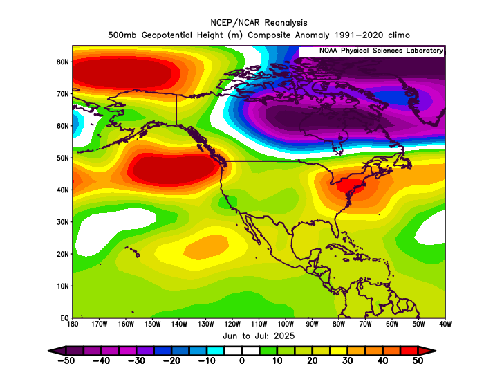
The Euro has the same winter pattern at 500mb as we are getting this summer. It’s a -EPO +PNA and Southeast Ridge pattern. Pattern persistence or the model is in repeater mode? Stay tuned….
-
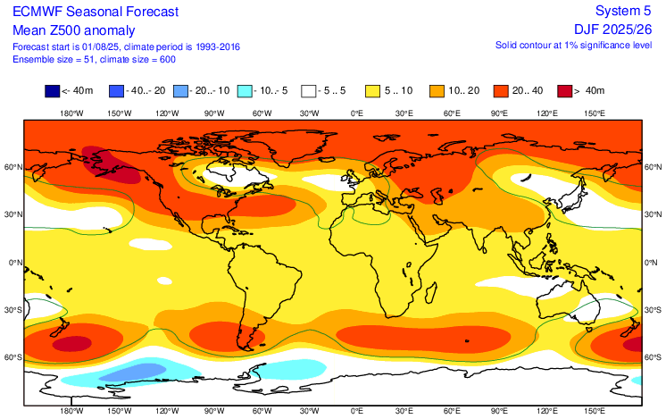
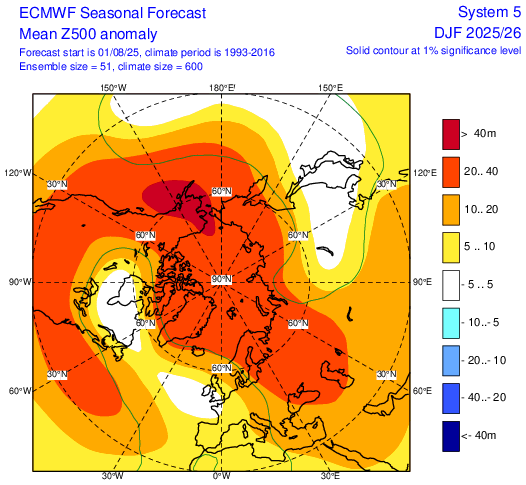
5H Dec-Feb Euro
-
Even though the air quality alert was taken off the forecast here in Delaware I can smell forrest fire smoke.
-
Already said it, but I agree with you on -PNA this winter….2nd year -ENSO….very strong tendency. As far as the NAO being “super” positive, I doubt it, but I could definitely see a predominant +NAO this winter, especially if this SST alignment continues through fall, other factors (solar, geomag, lack of a tripole in June) we already talked about argue for that too
-
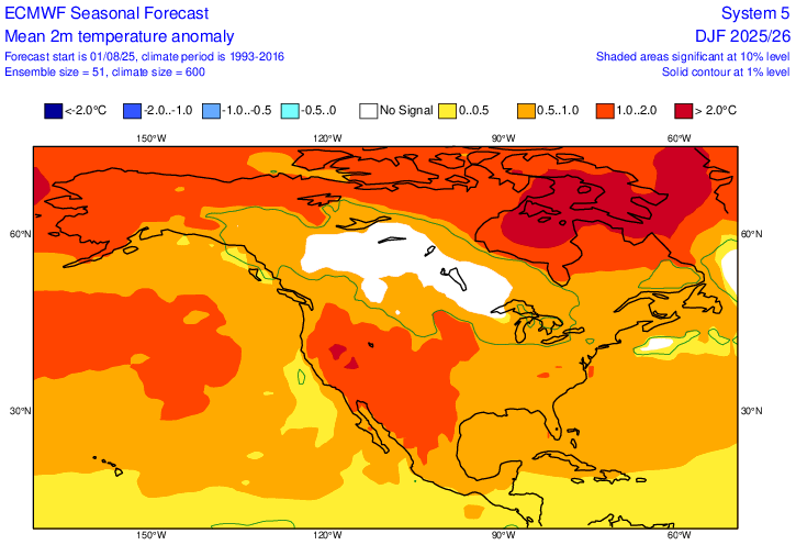
And DEC-FEB is +.5-1C. Very workable with normal precip it is also predicting. Monthly forecast indicates January very close to normal with February, like most Niñas, the most AN.
-
 71 / 67 - cloudy. Clouds will limit any shot at 90 still warm / humid mid - upper 80s, enough sun could get the hotter spots to 90. Cooler Wed, cloudy and isolated showers in the PM/ overnight. Clear out Thu and a great stretch Thu - Sunday - mainly clear, dry and near to slightly below normal. Flow comes around later on the 8/10-11 with a warm - hot / humid and wetter overall. Heat more widespread Tue - Thu next week. Flow still a bit onshore-ish. Tropics activity but overall ridging into the EC, - warm - hot at times , more humid and wetter with frontal boundaries and tropical systems to be watched. 8/5 - 8/10 : Overall near normal - dry 8/11 - Beyond : Warm- Hot - Humid - wetter overall - Tropical activity - heat 8/11 - 8/14 -tropics focus 8/15 onward. (Ctrl + Refresh) to update live satellite loop
 -

2025-2026 ENSO
donsutherland1 replied to 40/70 Benchmark's topic in Weather Forecasting and Discussion
The newly released ECMWF Seasonal Forecast for Fall shows somewhat warmer than normal conditions in the Central U.S. The CANSIPS with its cold outlook there is an outlier.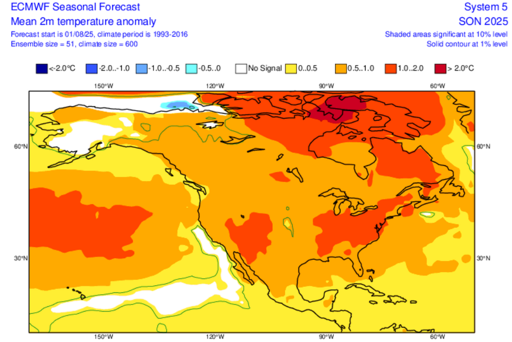
-
Updated Euro seasonal for August just out off free site. https://charts.ecmwf.int/?facets={"Product type"%3A["Experimental%3A AIFS"]%2C"Parameters"%3A[]%2C"Type"%3A[]%2C"Range"%3A["Seasonal"]}
-
August Euro seasonal just out off free site fwiw. https://charts.ecmwf.int/?facets={"Product type"%3A["Experimental%3A AIFS"]%2C"Parameters"%3A[]%2C"Type"%3A[]%2C"Range"%3A["Seasonal"]}
-
All pools in Philly metro are closed now. Hate to see it.
-
Well, the rain called/forecasted for late this evening thru tomorrow decided to arrive overnight.... currently 59.6/59.0.
-
I think the Pacific will continue to be much more important than what the NAO does. The last time we saw a few KU events was back in January 2022 with a solid +NAO pattern. The key was the strong MJO 8 which allowed the Pacific Jet to relax for a month. That was the last time many of us had a cold and snowy month. So we would want to see improvement from the Pacific Jet.
-
Poor Moregarbage.
-
With no real heatwave in sight, I'll call these the "happy" dog days of summer. Surely dont expect the respite from swamp ass humidity to last forever, but the back n forth for the next month would be fine by me, as the dog days are gone and the first chances of crisp autumn air showing up will be getting closer. Thats a win for me.
-
So much summer heat and dews are coming. The general public has no idea of what’s about to hit them
-
Wish we could lock it
-
Rip some spinners across SNE too.
-
Man euro is like 70+ dews perhaps starting Sunday, but definitely Monday through the end of the run.
-
Just saw that. 60kts off the deck with daytime heating.
-
There’s no doubt.
-
6z GFS Would blow down some trees
-
PA Weather Plus, LLC oprosSentdlacgaa1ha3i3a2u819ml5863lm8mt70hg12ahcgh131a77g0h6 · ** MUGGY METER UPDATE ** It's generally on up from here! Our humidity will be on the increase with our comfort on the decrease as we continue to push through the rest of the week, head into the weekend, and then into the beginning of next week. Next week is looking particularly warm and humid, with increasing dew point values & temperatures climbing into the upper-80s to low-90s, dangerous heat indices will be a concern in the afternoons once again (with daily storm chances). Summer is not over just yet- make the most out of it because we know we will all be complaining in just a few months! See less — in Pennsylvania.


.thumb.png.4150b06c63a21f61052e47a612bf1818.png)

