All Activity
- Past hour
-

2026-2027 Super El Nino
GaWx replied to Stormchaserchuck1's topic in Weather Forecasting and Discussion
Chris, June-July 1991 also didn’t get the memo: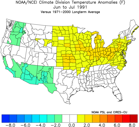
-

Central PA Summer 2026 Discussion/Obs Thread
mahantango#1 replied to Voyager's topic in Upstate New York/Pennsylvania
Please refrain from using the heater in your vehicle in July. One must not use the heater in a vehicle until late September. Don't give in to temptation. -
3.95”
-
Central PA Summer 2026 Discussion/Obs Thread
mahantango#1 replied to Voyager's topic in Upstate New York/Pennsylvania
US National Weather Service State College PA Favorites ·steprnoSdo396f351052g6h810cug4346m98517t4a4310t48287lm7208lu · Next 3 days: Doesn't get much better for late July Humidity and rain risk ramp up for early next week 7/23/26|638am -

Central PA Summer 2026 Discussion/Obs Thread
Blizzard of 93 replied to Voyager's topic in Upstate New York/Pennsylvania
57 for the low in Marysville. Should be a beautiful late July day. -
Wow there are some insane totals around Greensboro. We’re at around an inch here
-

2026-2027 Super El Nino
bluewave replied to Stormchaserchuck1's topic in Weather Forecasting and Discussion
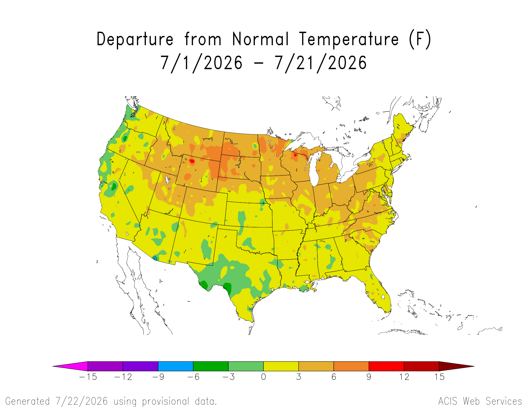
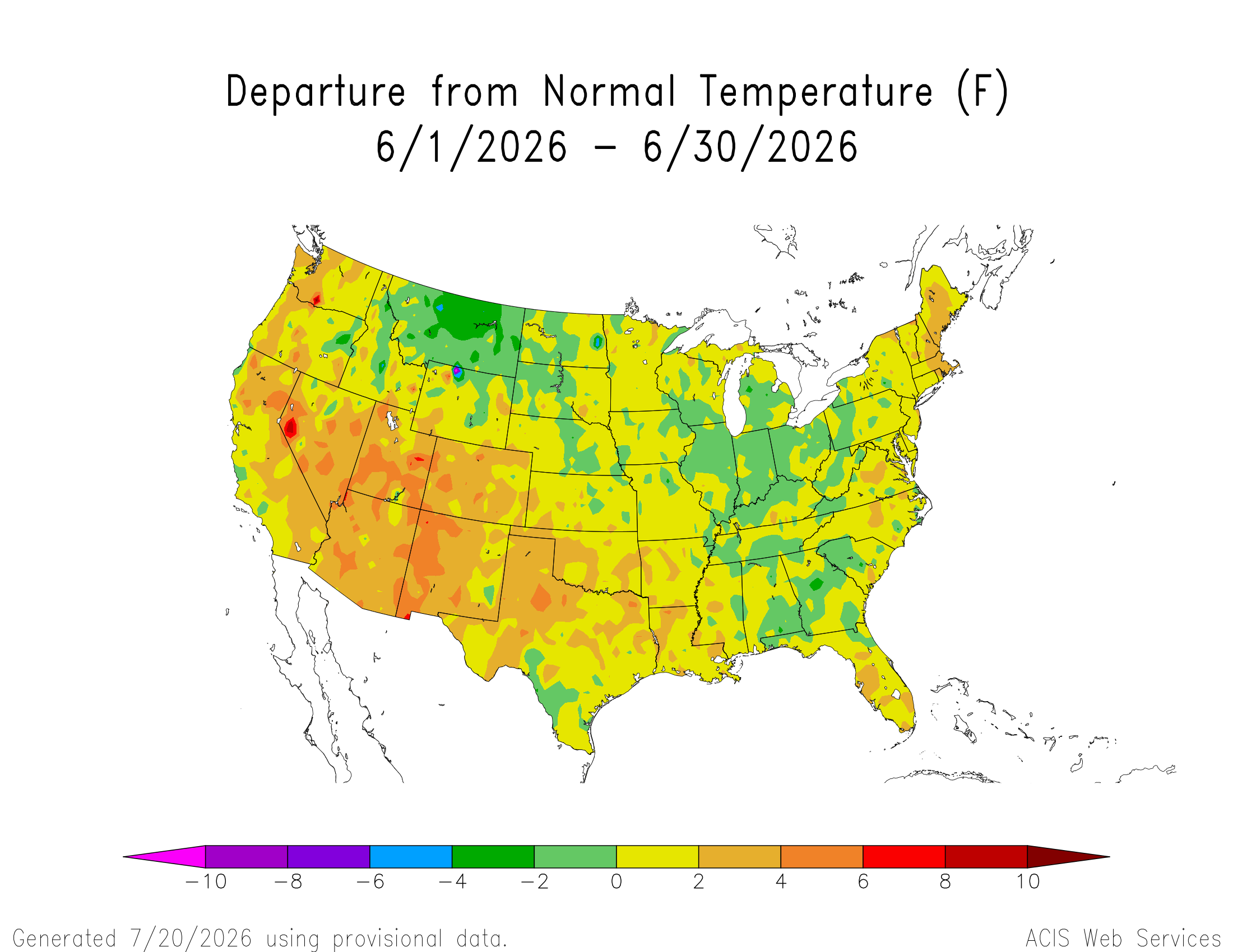
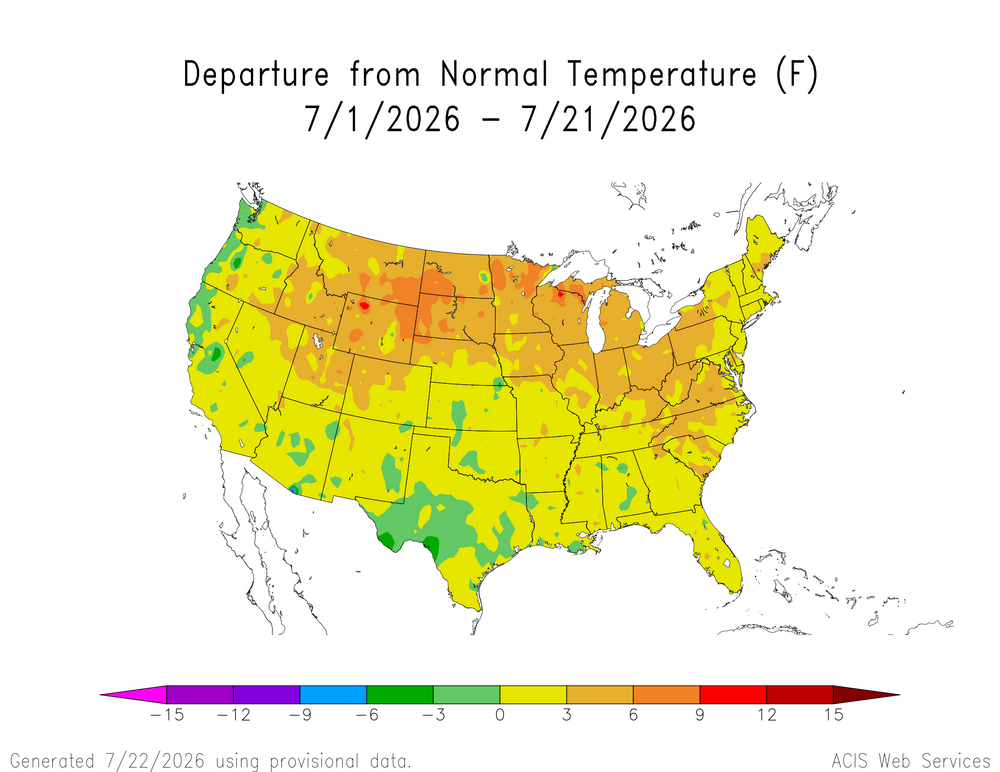
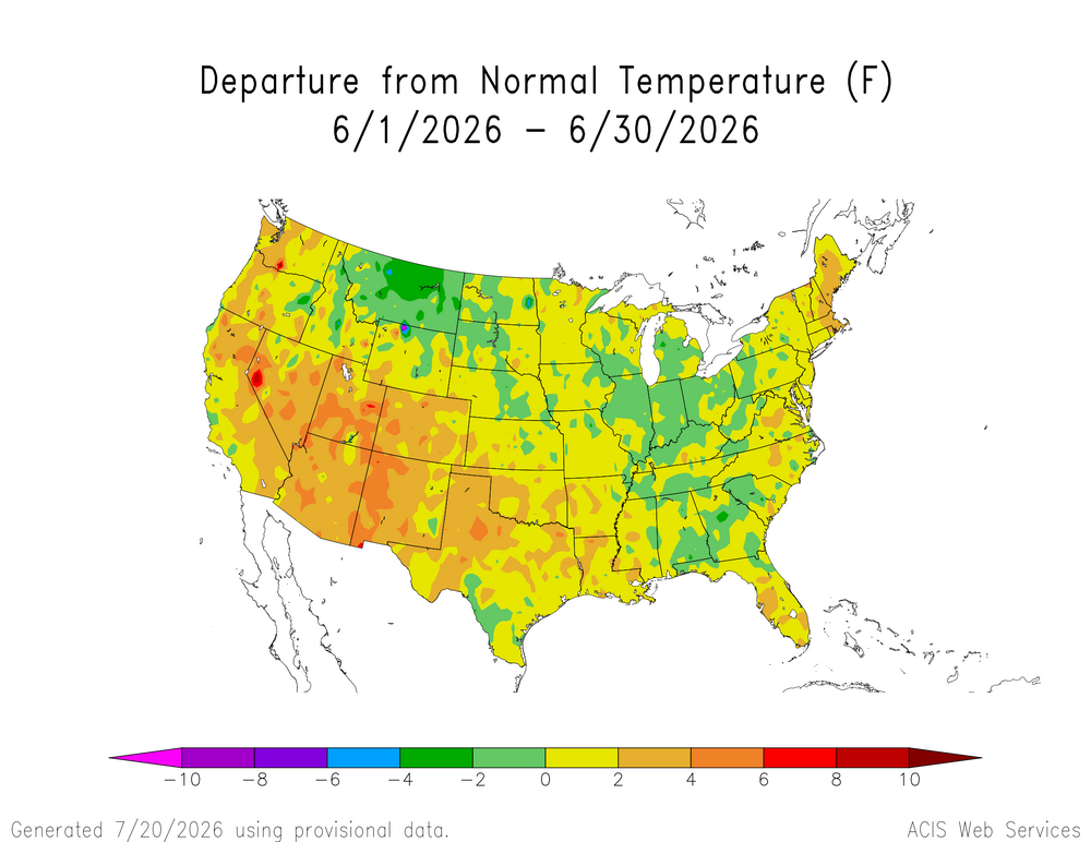
The CONUS didn’t get the memo that it’s supposed to be having a cooler super El Niño summer. We knew something was going to be different with the record heat that began to emerge back in May. What if anything this says about the rest of the event remains to be seen.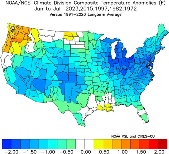
-
Got lucky with some training showers last night and picked up 0.75 for a total of 2.10 for the event. Best rainfall since I moved here in March. Now I'm looking forward to gorgeous weather the next four days.
-

2026-2027 Super El Nino
snowman19 replied to Stormchaserchuck1's topic in Weather Forecasting and Discussion
The 30C isotherm continues to be pushed further east of the dateline by the constant WWBs. It’s extremely likely that it gets pushed all the way to 140W by November like the models are showing, which would be record-breaking. The developing parade of typhoons are only going to enhance the westerlies/WWBs going forward. The warm pool east of the dateline has moved the downwelling Kelvin wave generation area to around the dateline to 165W. This means it will take less time for warm water to be transported into the EPAC, thus El Nino will grow very quickly from here on out. A record-breaking historic event is guaranteed at this point. I think we see forcing possibly set up the furthest east on record by late fall/winter. Here is a taste of what is to come on this side of the hemisphere with the STJ…… -

Central PA Summer 2026 Discussion/Obs Thread
Voyager replied to Voyager's topic in Upstate New York/Pennsylvania
53 this morning here. I'd be wearing jeans today for work if I had an earlier start than 8am. By the time I load the first tank of the day, the sun is starting to warm things up. Gonna need the heat in the car, though, for starters. -
Wow! This rain has been training over Hickory since about 6 PM last night. I have over 3 inches of rainfall so far.
-

Central PA Summer 2026 Discussion/Obs Thread
pawatch replied to Voyager's topic in Upstate New York/Pennsylvania
48 degrees this morning. Maybe start the day in jeans -
Central PA Summer 2026 Discussion/Obs Thread
mahantango#1 replied to Voyager's topic in Upstate New York/Pennsylvania
-
Central PA Summer 2026 Discussion/Obs Thread
mahantango#1 replied to Voyager's topic in Upstate New York/Pennsylvania
52 this morn. - Today
-
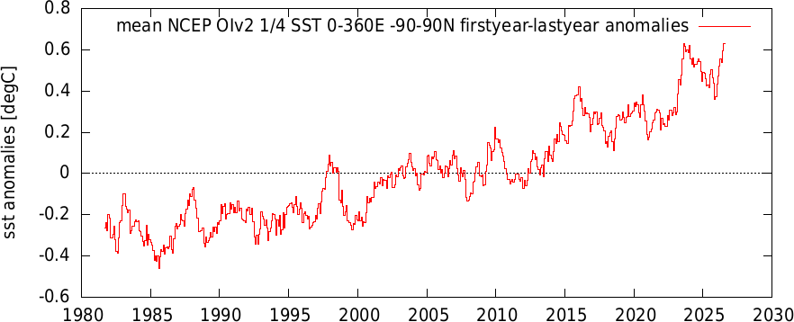
July to-date satellite OiSST has reached the peak anomaly from the 2023-24 nino.
-
 48.3°/46.7°. As @dendritehas pointed out, these temps didn’t used to be uncommon this time of year.
 -
 59° / 53° fallish feel.
 -
Harbor Freight has a 2000 watt inverter for $500 thats decent. Those inverter units can adjust the engine speed to the load so they are crazy efficient. So if your just running a low load device it will run the engine at like 1200 rpm instead of 3600 at full load. All the larger generators run at a fixed 3600 rpm and suck down gas. A 6500 watt generator will go through a ton of gas often 5-10 gallons a day. Those ecoflow and anker solar battery packs are also pretty awesome. I got a 2kw one at Costco that can run pretty much any 120volt device. It will power a fridge for 24 hours and they can be charged from a generator, solar, car, and regular ac outlet. These 2 devices are like less than $1500 as well.
-
 https://mesonet.agron.iastate.edu/ASOS/current.phtml?sortcol=ts&network=CT_ASOS&metar=no&sorder=asc&format=html https://xmacis.rcc-acis.org/
 -
 PrecisionRX: PrecisionRX - PrecisionRX
 -
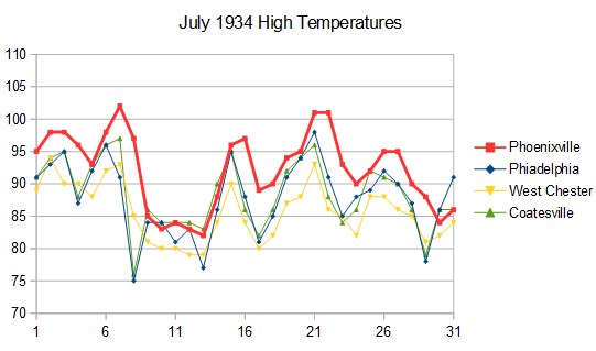
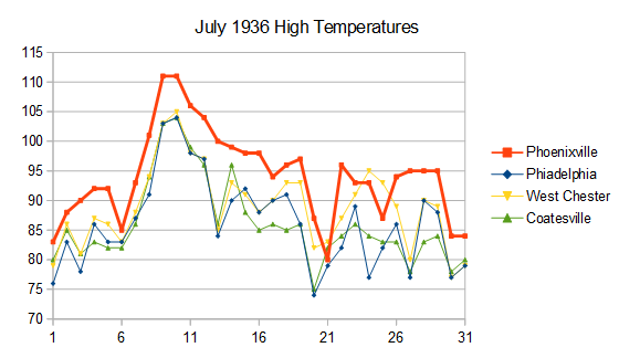
We have a good example in Chester County PA. Here are high temperatures for July 1934 and 1936 for 4 local stations. Phoenixville ran much warmer than the other stations probably due to poor shelter placement. Phoenixville also carried over hot temperatures to the next day when the other stations cooled. This shows that the Phoenixville max/min thermometer was flipped near the time of peak temperature while the other stations were not. Phoenixville completely dominates the # of 95 and 100F days in Chester County in the 1930-40s, but the data is spurious. This is why I don't trust plots of historic max temperatures in the US, unless the data has been scrutinized for bad data. Only takes one or two bad apple stations to create a spurious result.
-
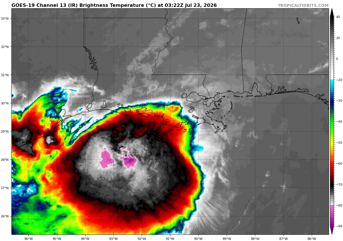
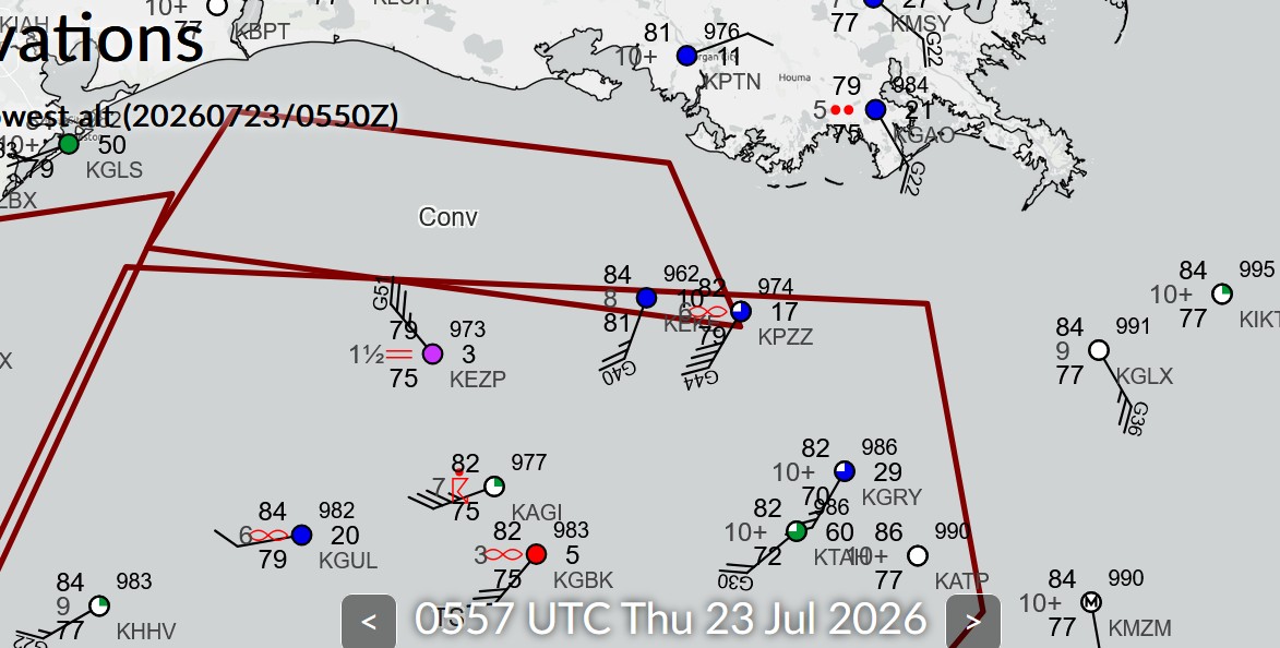
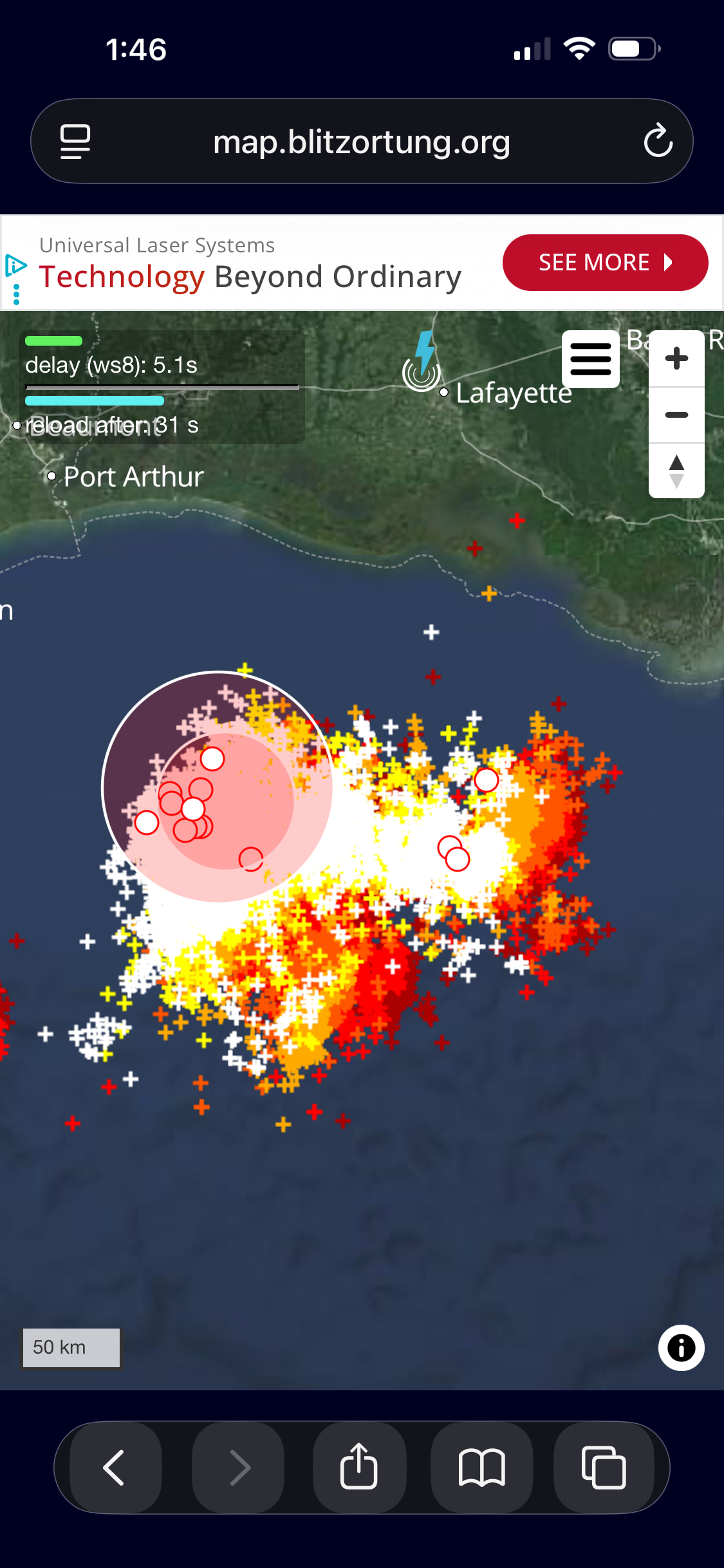
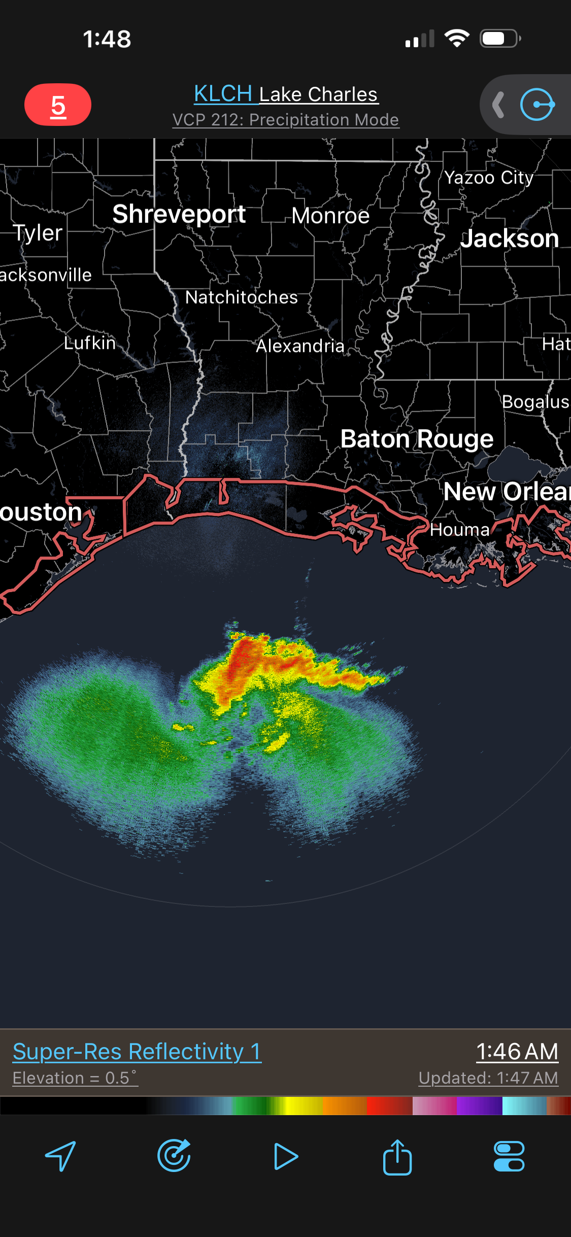
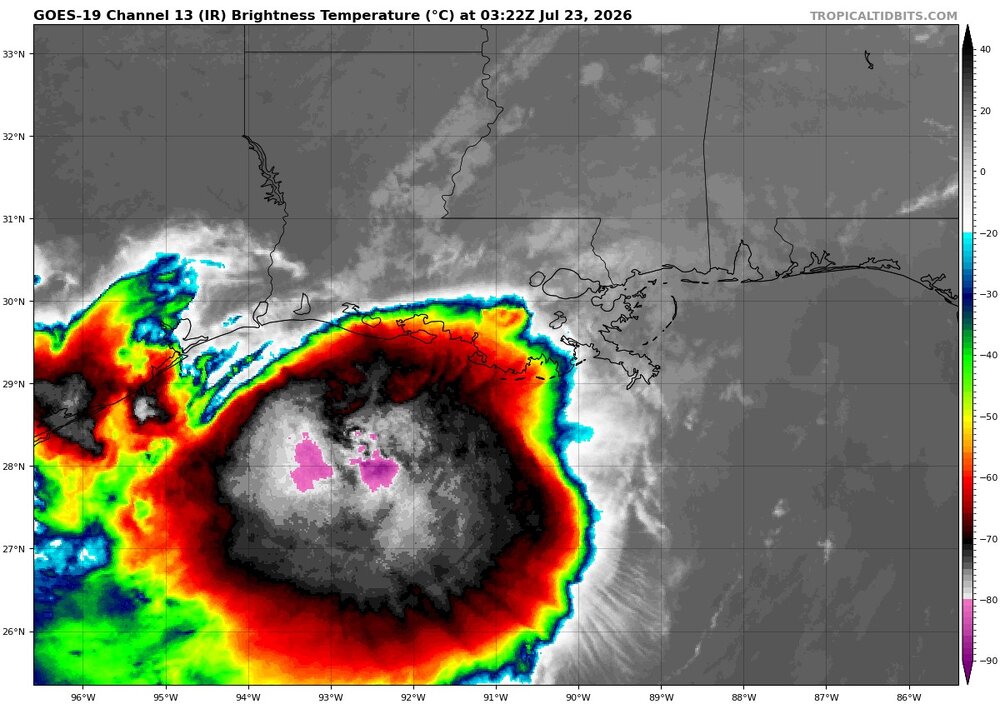
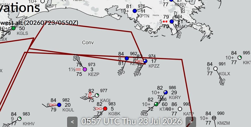
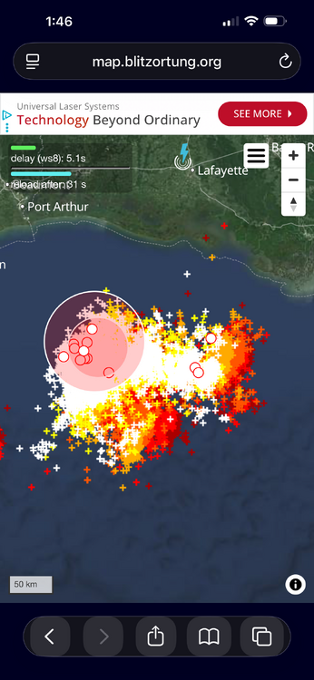
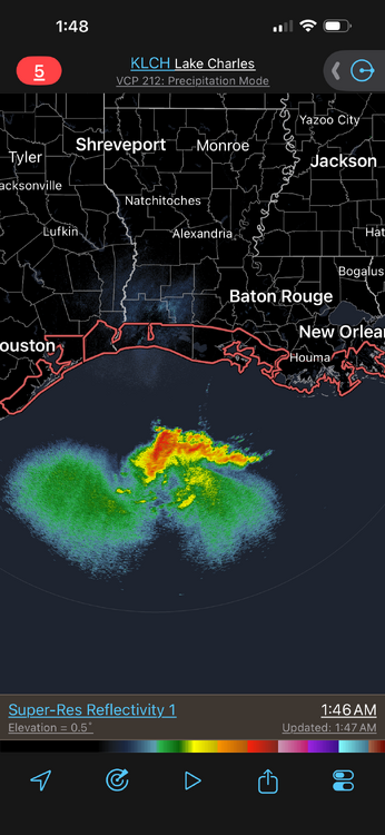
Now this is what I was talking about. Very intense convection b/c of the shear present. Cloud tops as cold as -90 C and an exceptional amount of CGs. Very dense. I attached a zoomed up image of the CG plot and it is still very dense! The strong shear in a tropical environment is promoting this intense convection. Looking at radar and then the EIR, you can see how these huge cold cloud tops are largely thick anvil w/ much small precip areas under it. Basically like a MCC or a supercell complex! Platforms in the Gulf are showing something going on as to a center much farther S and some mesoscale phenomena. KEZP earlier had sustained winds of 65G71KT at a height of 75 ft. This is transitory in squalls (svr tstms basically!). Here are some platform obs from near the possible new center. METAR KEKE 230535Z AUTO 20024G40KT 8SM BKN010 BKN014 OVC028 29/27 A2962 RMK A01 METAR KEKE 230515Z AUTO 22009KT 10SM SCT011 BKN016 OVC027 29/27 A2960 RMK A01 METAR KEKE 230455Z AUTO 18006KT 7SM SCT011 BKN016 OVC023 28/26 A2961 RMK A01 METAR KEKE 230435Z AUTO 36007G12KT 3SM HZ SCT014 BKN022 OVC043 28/26 A2960 RMK A01 METAR KEKE 230415Z AUTO 31018G24KT 10SM SCT011 BKN017 OVC043 29/27 A2959 RMK A01 METAR KEKE 230355Z AUTO 31025KT 1 3/4SM BR BKN011 BKN020 OVC027 29/27 A2958 RMK A01 VIS 3/4V5 METAR KEKE 230335Z AUTO 32024KT 10SM SCT016 BKN026 OVC065 29/27 A2959 RMK A01 METAR KEKE 230315Z AUTO 32033KT 10SM SCT013 BKN019 OVC060 29/26 A2956 RMK A01 METAR KEZP 230535Z AUTO 32035G51KT 1 1/2SM BR BKN003 OVC030 26/24 A2973 RMK A01 METAR KEZP 230510Z AUTO 27033G41KT M1/4SM FG OVC003 26/24 A2972 RMK A01 METAR KEZP 230455Z AUTO 23042G55KT M1/4SM FG OVC003 26/25 A2977 RMK A01 METAR KEZP 230435Z AUTO 21065G71KT M1/4SM FG OVC003 27/25 A2965 RMK A01 METAR KEZP 230415Z AUTO 25040KT 2SM HZ OVC036 29/25 A2972 RMK A01 METAR KEZP 230355Z AUTO 29034G42KT 5SM HZ BKN039 OVC045 29/25 A2968 RMK A01 METAR KEZP 230335Z AUTO 30042KT 7SM BKN043 BKN055 OVC070 30/25 A2966 RMK A01 METAR KEZP 230315Z AUTO 30041KT 8SM BKN046 BKN060 OVC120 30/25 A2967 RMK A01

-
Okay, I negged this front and its radar echoes earlier today in mid/long range thread and it has clearly told me to shove it. 2.5 inches and counting with a training line still going back 75 miles. Drought. Busting. .
-
.thumb.jpg.6a4895b2a43f87359e4e7d04a6fa0d14.jpg)
Central PA Summer 2026 Discussion/Obs Thread
Yardstickgozinya replied to Voyager's topic in Upstate New York/Pennsylvania
Spc mentions severe weather, returning to our area in the day 7 time frame.