All Activity
- Past hour
-
https://youtu.be/cYR4MScOVg4
-
Yep - 11/1 today. Halloween equivalent tomorrow Feb 10
-

Winter 2025-26 Medium/Long Range Discussion
hawkeye_wx replied to michsnowfreak's topic in Lakes/Ohio Valley
Multi-day mid-month blowtorch on tonight's GFS. It's not good to get that kind of stuff in February, so I hope it is overdoing the warmth. -
Feb 9 , 2017
-
These solutions are all over the damn place lol .
-
Awful model
-
And a miss on the GFS
-

-
Probably before many here were born, but today is 57-year anniversary of The Lindsay Storm. In Queens at the time and very difficult to measure. 17.7" was my best attempt. No pictures, but I remember tunneling into back yard where the snow was scoured out in the middle to some bare ground while surrounded by drifts reaching to the second floor.
-
 Wonder how long it'll take before the AIs finally correct themselves? Lol I'd bet on Day 5!
 -
Ukie!

-
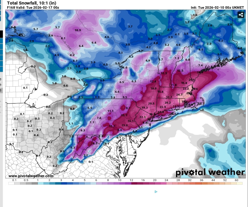
Boston gets smashed on ukie

-
 Almost time to shit the blinds on this threat.
 -

February 2026 Medium/ Long Range Discussion: 150K Salary Needed to Post
bncho replied to Weather Will's topic in Mid Atlantic
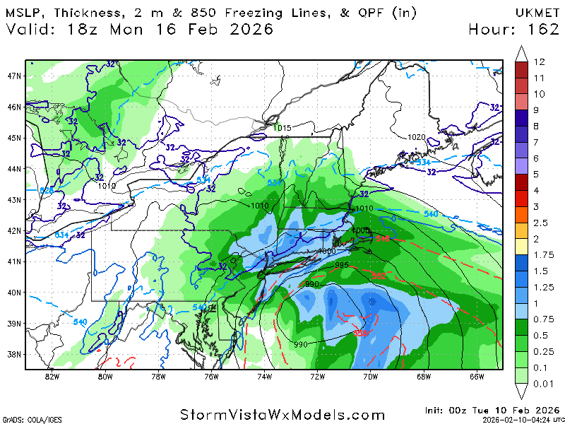
No you're right, the delay in the ejection of the shortwave allows the cold air to escape -
It sounds like the problem here is more of a timing isssue. In the runs that snowed the precip came in earlier. But with the most recent ones...things develop so slow that the cold air is already scoured out by the time the storm gets here. But I could be wrong. @psuhoffman feel free to clarify
-
 Can we please go back to the debate, this is unimportant.
 -
February 2026 Medium/ Long Range Discussion: 150K Salary Needed to Post
bncho replied to Weather Will's topic in Mid Atlantic
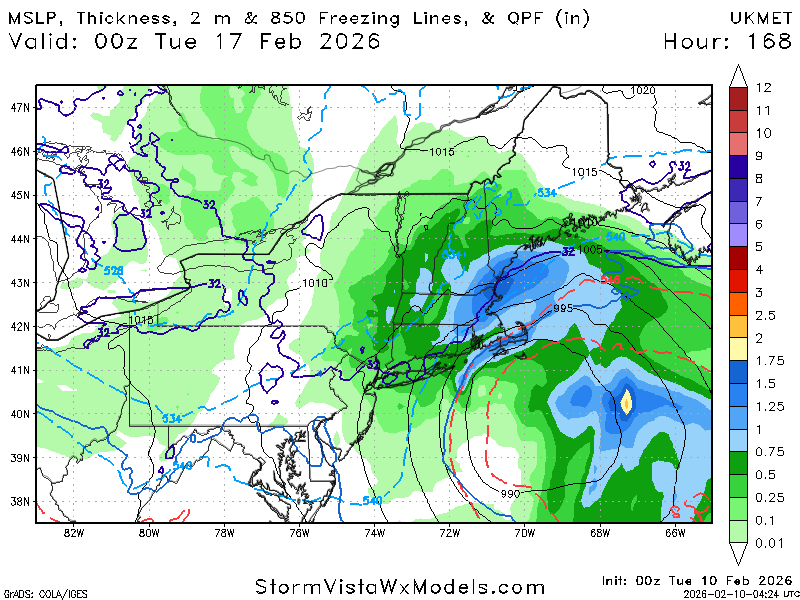
If the GFS verified it'd be a storm with no frozen at all in mid Feb, not even on the northern edge of precip (which extends to NYC), save for a few very tiny ZR pockets that are just 32 degree rain -

February 2026 Medium/ Long Range Discussion: 150K Salary Needed to Post
Amped replied to Weather Will's topic in Mid Atlantic
High over Bermuda, 500mb low tracking over Northern Florida. What more can you ask for from the GFS? -
i was in college at the time. i remember i was doing some school work in my room, and my roommate and his friend starting screaming "holy shit, holy shit" - I ran in and started watching. Just something that we had never seen and will probably never see again.
-
 Sorry to anyone who saw the increase of pages since about 6pm and said WOAH what happened only to see nothing did on the models…just debate club.
 -
malice in the palace!!!!! one of the most epic sports-related things of all time.
-
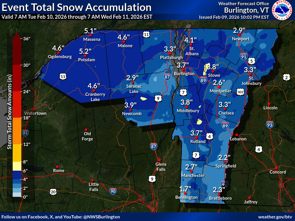
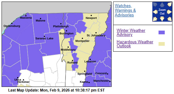
I was surprised this afternoon when I saw a Winter Weather Advisory appear in the alerts on my laptop, but the BTV NWS has them up for parts of the forecast area, including the western slopes of the Northern/Central Greens. On the Event Total Snow Accumulation map I see there’s some yellow 6-8” shading in the Northern Greens around here in the Bolton-Mansfield stretch, and that seems to align reasonably well with the mountain forecasts. Here at our site the numbers come in around 4-8” through Wednesday night, which is a little more aggressive than the general 4-6” shading along the spine, but we’ll have to see how long the snowfall persists – some models keep the upslope snow showers going through Thursday. The modeling also has another system coming through the area on Saturday, and with temperatures finally getting back to more normal values, we could be in line for some excellent days to hit the slopes.

-
Well...at least this is an on-topic back and forth But still though...lol
-
 Too bad we had a Nina STJ this year. It was a nina-stj last winter too. Too bad, the AO was favorable