All Activity
- Past hour
-
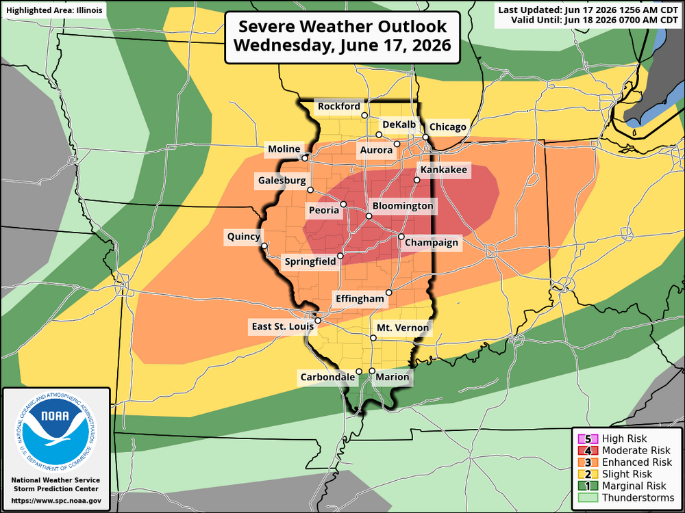
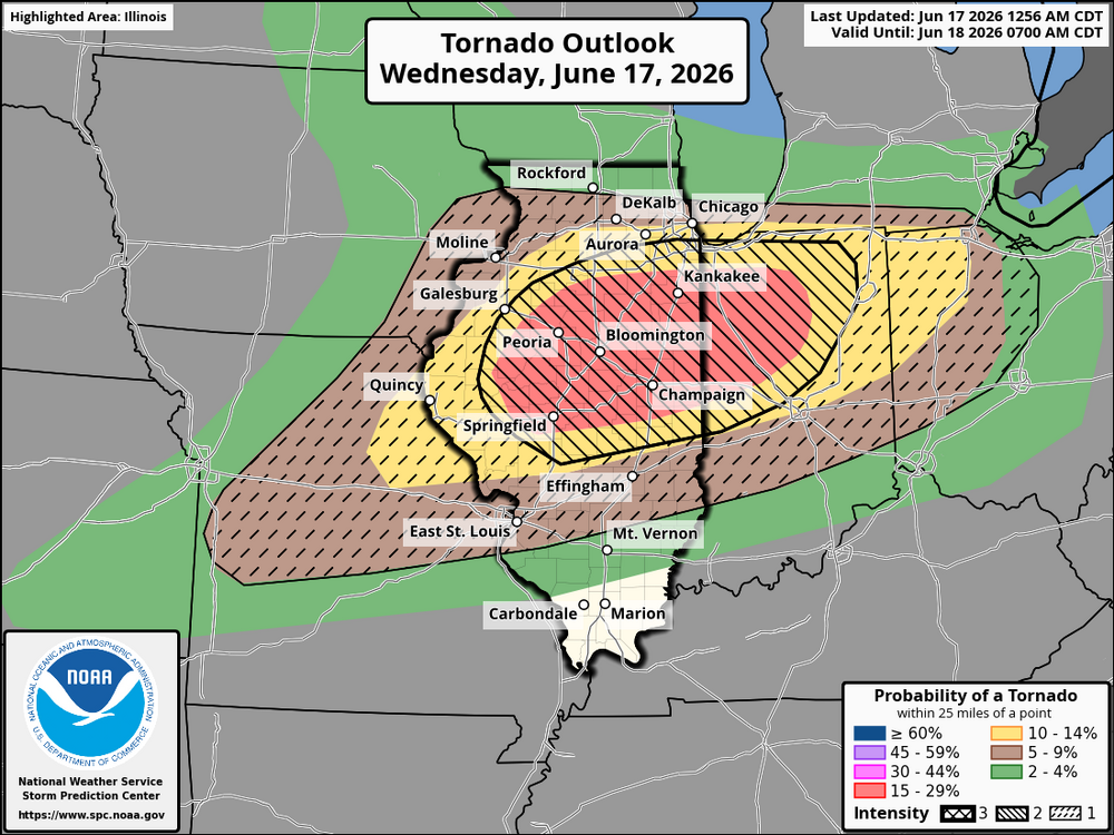
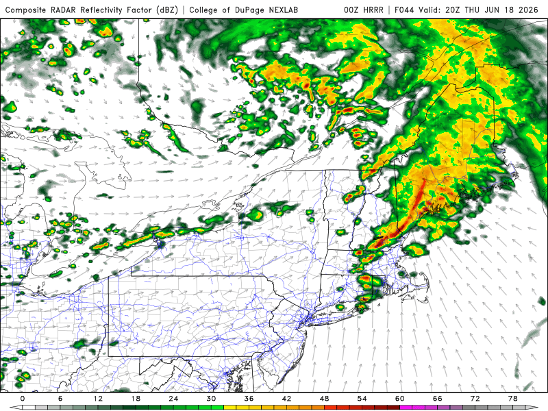
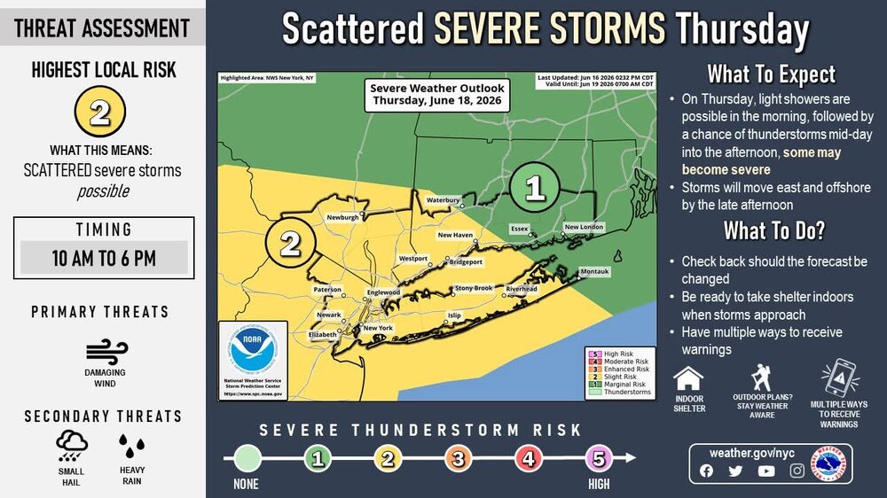
SPC not making many changes to the Day 1 forecast except extending the 10% tornado risk and CIG 2 north. There maybe more small changes but it’s too late to dig into it. A great read below. Day 1 Convective Outlook NWS Storm Prediction Center Norman OK 1256 AM CDT Wed Jun 17 2026 Valid 171200Z - 181200Z ...THERE IS A MODERATE RISK OF SEVERE THUNDERSTORMS OVER ILLINOIS AND INDIANA... ...SUMMARY... An outbreak of severe thunderstorms is expected today, with primary threat centered over Illinois and Indiana. Several intense tornadoes, swaths of damaging gusts over 75 mph and damaging wind-driven hail will all be possible. ...IL...IN...MO...OH... An intense mid and upper level jet will nose southeastward across the Midwest today, with a prominent leading disturbance moving out of IA and into IL through midday. Severe storms are likely to be associated with this early wave as a southwesterly low-level jet increases to 60 kt and rapidly bring instability into the area. This initial activity will bring damaging winds to eastern IA and northern/central IL. This system is expected to weaken later in the afternoon, but some remnants will move across IN. Ahead of this early activity, a warm front will push north across IN and OH. New severe storm development, perhaps transitioning out of the remnant activity and/or forming near the warm front, is possible across northern IN into northwest OH. Shear profiles will be excessive, with tornado risk only conditional on minimal instability being present. The result may be a isolated tornadic supercells. To the west, the air mass across northern MO, IL, and into central IN will easily recover and rapidly destabilize due to strong southwest winds. A 60+ kt low-level jet is forecast, with notably strong winds around 700 mb as well (surface to 3 km shear values may exceed 60 kt). A plume of 65-70 F dewpoints will likely extend from central MO into IL and western IN in the 21-00Z time frame, contributing to 2000-3000 J/kg MLCAPE. A broken line of supercells is likely to develop and mature roughly from northern IN into central IL and MO around 21Z and spreading east/southeast through early evening. Given the clearly supercellular shear profiles, linear storm mode is unlikely for most of the event. Long-tracked supercells producing tornadoes and damaging hail are likely. Finally, the warm frontal position will need to be monitored near the IN/MI border. Even if instability is elevated into MI, extreme shear and lift may still yield damaging winds and even a tornado risk. As such, probabilities have been increased into far southern Lower MI. ...Upper TX Coast into the northern Gulf Coast... The NHC forecast shows Potential TC One moving into southwest LA by 00Z. Wind fields associated with this system will strengthen out of the south ahead of it, resulting in areas of strong low-level shear from TX into southern LA, and possibly into MS. Mid to upper 70 F dewpoints will contribute to modest CAPE values, supporting embedded stronger cells with tornado potential. ..Jewell/Weinman.. 06/17/2026
- Today
-
EML for sig tor outbreak, yes, but it depends what we expect. SPC isn't going big, and I agree w/ how they are approaching it. However, I think the uncertainty is higher than usual due to the setup. When you have high-end anomalies, such as the wind fields here, that can lead to more surprises. I said earlier, I don't have a good analog for this particular setup, so that makes me nervous as to the surprise factor.
-
I wasn't comparing them like that-lol but both seem to be missing steep ml llase rates, and that is usually the one key missing ingredient in sne setups that fail.
-
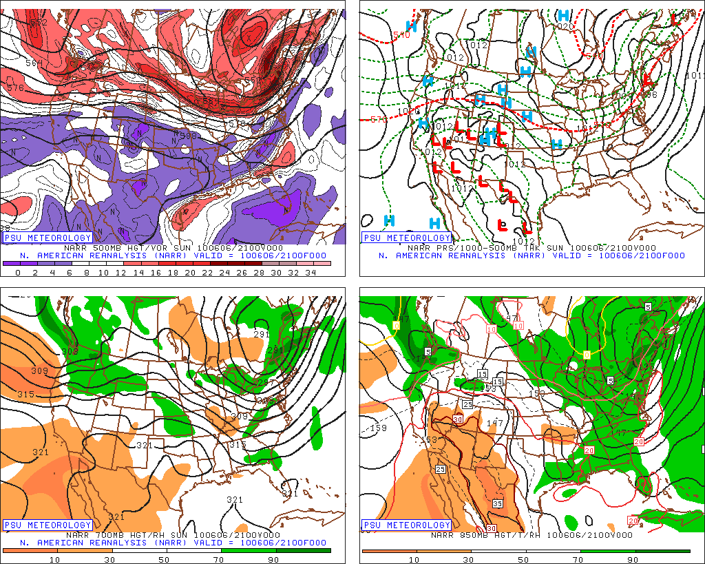
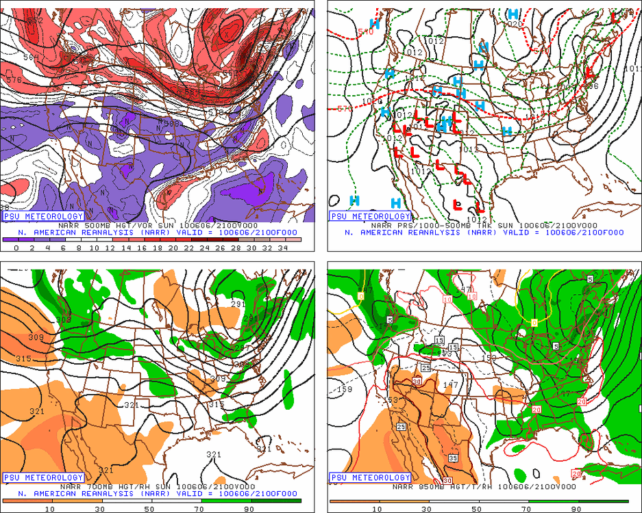
Took a look at it (attached). Not quite the same. Sfc low passed right over SNE rather than over srn Quebec. Also, sfc low Thu deeper than 2010 by 8-10 mb. Too much cloudiness in 2010? Even if this was very similar to 2010, minor differences can be a huge as to sensible wx when it comes to convective potential and the type of svr wx they produce, let alone how intense any given svr wx type may be. Also, I think we may be unimpressed by the SPC DY2 MRGL. Just b/c MRGL says zero about how intense any storm may be and the svr wx it produces. Maybe instead of three well-defined tornadic supercells that occurred on 7/10/89, they may be only one! But for ppl like WxWiz and CoastalWx who are always looking for the absolute max? One honkin' supercell is not enough!
-
I haven't given up on Thursday - 0z mesos look okay wrt potential
-
Yes, one of the most memorable ever, really. tremendous shear - weak/mid cape - terrible ml lapse rates/ml cape. SPC was at least a moderate hatch if not high risk? it was wild. Very little happened
-
I don't recall that day. Big bust?
-
funny because the very next year produced some of the highest end severe we've seen in a century ofc largely EML-driven
-
6/6/2010 ...forever gun-shy
-
Potential Tropical Cyclone One Discussion Number 3 NWS National Hurricane Center Miami FL AL012026 1000 PM CDT Tue Jun 16 2026 The center of the system is beginning to emerge into the northwestern Gulf. Surface observations do not show very strong winds over the area at this time, and the current intensity is held at 25 kt. This is consistent with a Dvorak classification from TAFB. There is significant westerly vertical wind shear over the disturbance, with most of the deep convection displaced well away from the center of the low. Given that there has been no noticeable increase in the deep convective organization of the disturbance, it is being maintained as a potential tropical cyclone for this advisory. Based on the center fixes, the initial motion estimate, 050/5 kt, is similar to that from the previous advisory. There has been little change in the track model guidance. The system is expected to accelerate northeastward in the flow on the southern and southwestern side of a broad mid-level trough over the eastern United States. The official forecast track shows the disturbance or storm moving just offshore of, and parallel to, the Texas coast during the next day or so. Then the system is likely to go back onshore late Wednesday or Wednesday night. No significant change has been made to the track forecast for this advisory, and the official forecast is fairly close to the corrected consensus solution. The center should move far enough offshore on Wednesday for some intensification to occur due to a combination of warm Gulf waters and upper-level divergence. However the SHIPS guidance diagnoses fairly strong shear over the area during the next 24-36 hours which should limit strengthening up to landfall. The NHC forecast continues to indicate the system becoming a tropical storm tomorrow, which is also shown in the IVCN intensity model consensus. Regardless of whether the system becomes a tropical cyclone, heavy rainfall and life-threatening flash flooding will be the primary hazards with this system. KEY MESSAGES: 1. Potentially life-threatening flash and urban flooding is likely through Thursday across Louisiana and southern Mississippi, and is possible near the Upper Texas coast. Flash flooding is also possible across Alabama, Georgia, and the Florida Panhandle through the end of the week. Prolonged rainfall may extend the flood threat into the weekend. 2. Tropical-storm-force winds are expected along the Louisiana coast on Wednesday from Sabine Pass to Morgan City where a Tropical Storm Warning is in effect. 3. Minor to moderate coastal flooding is expected along portions of the Upper Texas and Louisiana coastlines. FORECAST POSITIONS AND MAX WINDS INIT 17/0300Z 27.6N 97.1W 25 KT 30 MPH...POTENTIAL TROP CYCLONE 12H 17/1200Z 28.5N 95.6W 30 KT 35 MPH...TROPICAL CYCLONE 24H 18/0000Z 30.2N 93.3W 35 KT 40 MPH...INLAND 36H 18/1200Z 32.1N 90.9W 20 KT 25 MPH...INLAND 48H 19/0000Z...DISSIPATED $$ Forecaster Pasch/Adams
-
Concerning low CAPE and high shear, look at what happened on 4/1/2023 in DE. WxWiz in disbelief and CoastalWx proby "MEH!" LOL. https://x.com/riotrogerriot/status/1642347623733444609 This is a full-blown tornadic supercell, but it doesn't look like one b/c the CAPE was low and shear very high. The CB is tilted over almost 90 deg! 500-1000 CAPE this day, but want to know what the 0-6 km shear was? 100 kt! This storm produced a long-tracked EF3. Isolated storm all by itself in the Delmarva. https://www.youtube.com/watch?v=4esg-DNoO5s https://www.youtube.com/watch?v=FyVPX7-ZHhw Other cells this day in DC area (not svr - I witnessed personally), they were just like this, so ridiculously titled over, they did not look like CBs, just a TCU cloud line. The rain/hail from these storms was *way* downwind (5+ mi) from the rear updraft base (it was hard to tell these bases existed b/c of the extreme tilt!). One my co-workers who lives near BWI reported he just started getting 1/2" hail and no rain falling, or any idea there was a storm near b/c of the odd storm orientation and no LTG/T. Something you'd more typically see in the Plains or Desert SW. Quite atypical for the East Coast, but it shows it can happen. And what do we have coming up for Thu? Quite atypical. "Hope floats" WxWiz!
-

Potential Tropical Cyclone One
WxWatcher007 replied to WxWatcher007's topic in Tropical Headquarters
Potential Tropical Cyclone One Discussion Number 3 NWS National Hurricane Center Miami FL AL012026 1000 PM CDT Tue Jun 16 2026 The center of the system is beginning to emerge into the northwestern Gulf. Surface observations do not show very strong winds over the area at this time, and the current intensity is held at 25 kt. This is consistent with a Dvorak classification from TAFB. There is significant westerly vertical wind shear over the disturbance, with most of the deep convection displaced well away from the center of the low. Given that there has been no noticeable increase in the deep convective organization of the disturbance, it is being maintained as a potential tropical cyclone for this advisory. Based on the center fixes, the initial motion estimate, 050/5 kt, is similar to that from the previous advisory. There has been little change in the track model guidance. The system is expected to accelerate northeastward in the flow on the southern and southwestern side of a broad mid-level trough over the eastern United States. The official forecast track shows the disturbance or storm moving just offshore of, and parallel to, the Texas coast during the next day or so. Then the system is likely to go back onshore late Wednesday or Wednesday night. No significant change has been made to the track forecast for this advisory, and the official forecast is fairly close to the corrected consensus solution. The center should move far enough offshore on Wednesday for some intensification to occur due to a combination of warm Gulf waters and upper-level divergence. However the SHIPS guidance diagnoses fairly strong shear over the area during the next 24-36 hours which should limit strengthening up to landfall. The NHC forecast continues to indicate the system becoming a tropical storm tomorrow, which is also shown in the IVCN intensity model consensus. Regardless of whether the system becomes a tropical cyclone, heavy rainfall and life-threatening flash flooding will be the primary hazards with this system. KEY MESSAGES: 1. Potentially life-threatening flash and urban flooding is likely through Thursday across Louisiana and southern Mississippi, and is possible near the Upper Texas coast. Flash flooding is also possible across Alabama, Georgia, and the Florida Panhandle through the end of the week. Prolonged rainfall may extend the flood threat into the weekend. 2. Tropical-storm-force winds are expected along the Louisiana coast on Wednesday from Sabine Pass to Morgan City where a Tropical Storm Warning is in effect. 3. Minor to moderate coastal flooding is expected along portions of the Upper Texas and Louisiana coastlines. FORECAST POSITIONS AND MAX WINDS INIT 17/0300Z 27.6N 97.1W 25 KT 30 MPH...POTENTIAL TROP CYCLONE 12H 17/1200Z 28.5N 95.6W 30 KT 35 MPH...TROPICAL CYCLONE 24H 18/0000Z 30.2N 93.3W 35 KT 40 MPH...INLAND 36H 18/1200Z 32.1N 90.9W 20 KT 25 MPH...INLAND 48H 19/0000Z...DISSIPATED $$ Forecaster Pasch/Adams -
Yes, this is a significant concern. Too much shear and not enough instability. You can get "cannonball CU" -- the building CU gets sliced by shear and you get part of the CU horizontally shooting downwind abruptly w/ a small cloud trail back to the other part of the CU! However, this go/no go for any CB here "winning" or "losing" is a fine line. If any CB can get established, the mesocyclone should be intense, and then CAPE does not matter nearly as much. It's why you can have as little as 100-200 CAPE and get sig tors. Most often this is in a TC situation, but it can happen in an ET low situation. CB updrafts are maintained extremely well despite low CAPE due to dynamic pressure perturbations induced by the mesocyclones. It also is why when an intense supercell moves into a stable (no CAPE) air mass, it can still produce tors for a little while longer b/c the intense mesocyclone present just doesn't go "poof!" The ante Thursday here is high here either way. It will definitely be a wicked nowcast situation watching storm development and evolving
-
Loved the sky today, so many storm clouds encircling. Saw multiple anvils, a quick t-storm just 1 flash, then cloudy til 10pm when we got our delayed 1mm of rain. Multi lines in SON today. Heaviest rains in the coming historic days will be during night. 18z Euro has a 984mb low very close to me on Thurs morning, easily the deepest for June. TWN was using David Roth's maps showing the departures.
-
Today's Highs: EWR: 80 New Brnswck: 78 LGA: 78 TEB: 78 PHL: 78 BLM: 77 ACY: 77 NYC: 76 TTN: 76 JFK: 75 ISP: 74
-
I would caution this does not always work well. June 2, 1990 has a big tor outbreak in the Great Lakes/Midwest/OH Valley w/ IN getting absolutely crushed w/ 37 tor in the state (more than the 1974 Superoutbreak). 66 tor in this event w/ 7 F4s, and forecasts were big for NY/PA and New England for June 3, and a complete bust. https://en.wikipedia.org/wiki/June_1990_Lower_Ohio_Valley_tornado_outbreak
-

2026-2027 Super El Nino
forkyfork replied to Stormchaserchuck1's topic in Weather Forecasting and Discussion
our willpower is working -
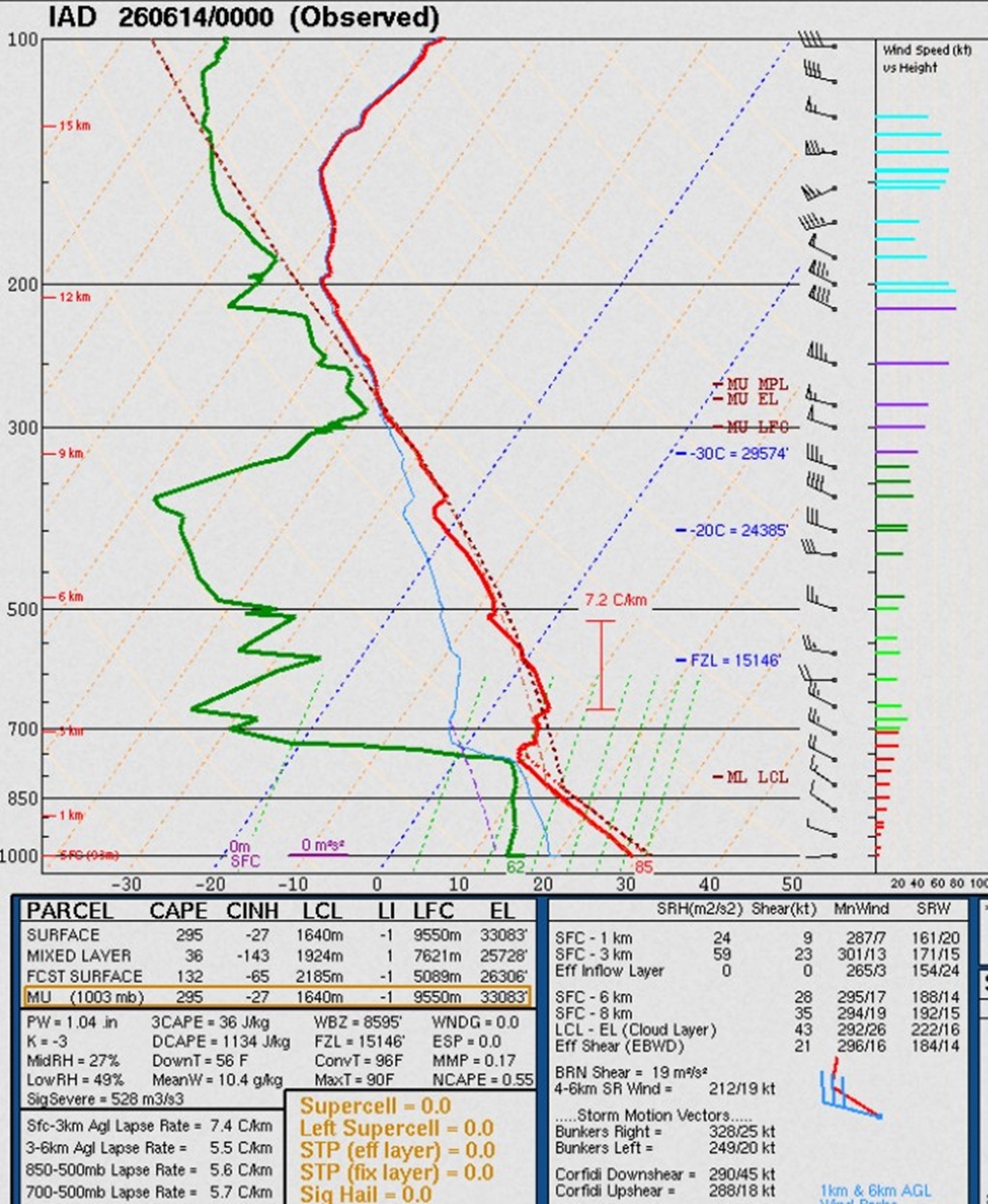
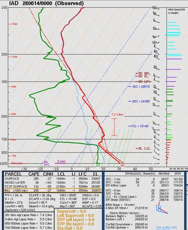
Timing is ideal and HRRR/RRFS show decent cells/lines! CBs in that kind of shear are likely going to do "something." I put it this way, "to have such a deep sfc low move over srn Quebec w/ those kinds of warm sector wind fields in June?, prove it to me something big will not happen!" We do not have set ups like this very often, so the full range of what can happen we really don't know. And this set up odd in itself b/c through the roof shear and low CAPE, but it not during the cool season! One thing about EMLs. 700-500 *only* can be misleading. Take a look at the IAD sounding 00z 6/14 I attached. 700-500 is crappy at 5.7 C/km, but compress that layer just a bit, and the max is 7.2 C/km...EML! I needed to inform CoastalWx about this, and he learned something new today!
-
That would reverse jinx a monster F4 cruising just south of the tower.
-

2026-2027 Super El Nino
Stormchaserchuck1 replied to Stormchaserchuck1's topic in Weather Forecasting and Discussion
^I can never get U of Del Air Temp working on the correlation composite. Is there a secret to it? June will likely be the 5th straight month of -PNA (CPC). I've found that the correlation roll forwards are weak for what happens later in the year, surprisingly. -
That's the issue w/ AI models. They can't handle outlier events or set ups well, so they underdo things. Also, AI overdoing it is possible as you noted above. Not a one-side problem I bet (non-linear factors). I keep hearing, "AI will get better." Well, isn't that the case for all types of modelling w/ time? And the notion that AI is improving so fast acting like it will solve all problems? All the AI advancement in the world is meaningless if you don't have many outlier events/analogs for it to pull from! And since outlier events are rare, progress in AI forecasts should be very slow. I would argue physics-based models will advance faster as in situ/remote observations get better globally for improved model initialization, along w/ better direct simulation of the atmosphere.
- 767 replies
-
- 3
-

-

-
- severe
- thunderstorms
- (and 7 more)
-
In any given situation, the worst-case scenario is the least likely to happen in the mean. The notion, "better safe than sorry" is a weasel line to give an excuse to always go w/ the worst-case scenario. Also, "we are saving lives!" Forecasts and awareness has become so good in recent decades, one can't hide behind that as an excuse anymore. Lives are lost now more IMHO b/c people have become numb and apathetic to the relentless hype. They have no idea what to believe, so many just tune it all out. That ends up costing lives when a truly exceptional event (worst-case) occurs, and it's made even worse b/c the exceptional events are greatest risk to lives. I admit though this is an extremely complex social issue, among other things, and no easy way to figure out what works best. One thing i will stand by solid though. "more [warnings/alerts} is not always better!"
-
-

2026-2027 Super El Nino
raindancewx replied to Stormchaserchuck1's topic in Weather Forecasting and Discussion
For anyone wondering - June is a pretty canonical -PNA pattern so far. Not PDO or ENSO driven. Despite the rumor that +PNA = +ENSO, it's never really been true in the Summer. CPC has the PNA as so weak in the Summer that is just has -- for PNA correlations to ENSO - not 0, not -0.87 or +0.33 actual blanks. https://psl.noaa.gov/data/correlation/table/corr.table_jun.txt -PNA June = Cold NW, Hot SW. Green on the lower map is positive correlation (-PNA = cold, +PNA = warm) while blues are opposite correlation (-PNA = warm, +PNA = cold). You can see the neutral spot over the Southeast shows up as well. -
Snowfall measuring practices were not completely standardized until the mid 1990s, even for long-term climate sites, and NYC is not immune to this issue. I think I have said this before, but generally, snowfall was underestimated prior to the NWS MAR in the 1990s. Some sites would only measure new snow *depth* once the storm was done, and call that the total. Other would melt a column of SOG, and then multiple by 10 for the snow total (blasphemy for the uber weenies!). Of all primary wx measurements we do, snowfall is by far the most inaccurate and variable in our record. Even today, there are fundamental challenges that make it hard at times to get an actual accurate amount.


.thumb.gif.f92b16c631a1d15d405ed77b33f0710d.gif)