All Activity
- Past hour
-
First week of October looks very dry. A frontal passage might bring some rain early in the second week of the month, but a lot can still change by that time.
-

Spooky Season (October Disco Thread)
Damage In Tolland replied to Prismshine Productions's topic in New England
Will be some 90 degree readings -
I live for these imaginary storm warnings.
-

Spooky Season (October Disco Thread)
CoastalWx replied to Prismshine Productions's topic in New England
Yeah fair enough. Looks like early next week is probably the last of the true 80s. -

Spooky Season (October Disco Thread)
40/70 Benchmark replied to Prismshine Productions's topic in New England
Well, that is a flip from 86F...not saying it's gonna snow lol -

2025-2026 ENSO
michsnowfreak replied to 40/70 Benchmark's topic in Weather Forecasting and Discussion
Interesting! Our lows are a bit more elevated due to lots of overcast nights, though we still drop below zero several days annually. -
That was all I commented on...I don't think the series is over or anything.
-
Spooky Season (October Disco Thread)
CoastalWx replied to Prismshine Productions's topic in New England
I think out west and into the Plains may see some decent shots. Maybe some spills east. -

Occasional Thoughts on Climate Change
donsutherland1 replied to donsutherland1's topic in Climate Change
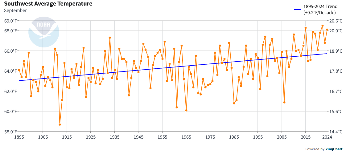
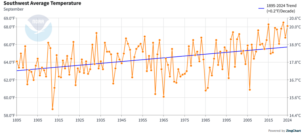
September 2025 in Phoenix marked the fourth consecutive year with a monthly mean temperature at or above 90°, a milestone never before observed in Phoenix's historical climate record which goes back to 1895. This persistent late-summer heat is consistent with the broader impacts of climate change, which is driving rising temperatures, more frequent and intense heatwaves, and shifts in seasonal patterns across the Southwest. Although internal variability influences any single month's weather, the sustained nature of recent September heat underscores a long-term warming trend fueled by anthropogenic greenhouse gas emissions. September also saw an hourly rainfall record set on September 26th. During a severe thunderstorm with large hail and gusts of 56 mph, Phoenix received an hourly rainfall amount of 1.09". Even as the Southwest is undergoing aridification, an increasingly intense hydrological cycle driven by ongoing warming can produce intense rainfall amounts.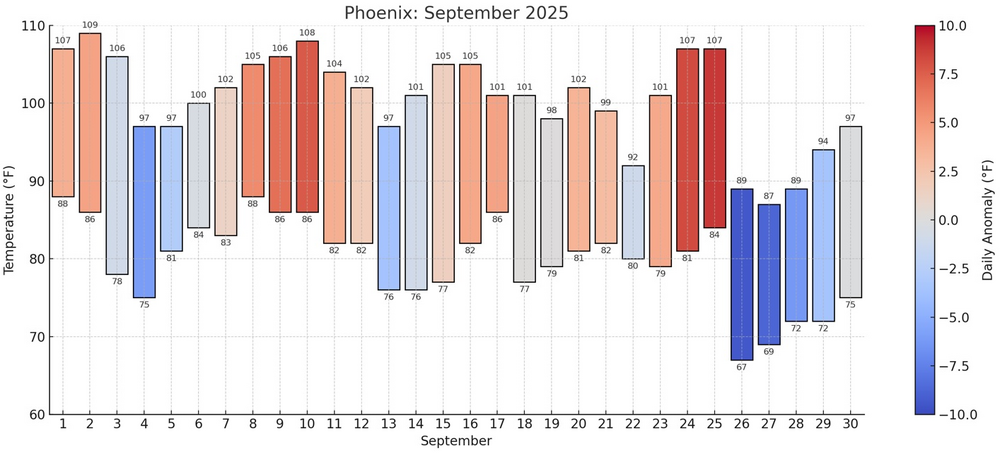
-
I think my sentiment was deserved...you have ripped Chapman from the day they signed him...going on about how he always melts when the lights get bright. Sorry, dude...he shoved it right up your tailpipe when the lights were brightest, and it should go without mention?? BS-
-
Spooky Season (October Disco Thread)
40/70 Benchmark replied to Prismshine Productions's topic in New England
Some signs of a flip in the latter third or so of this month. -
All models were wrong at one point. Most had them either hitting the coast and moving inland or stalling right at the coast.
-
Breath of fresh air outside this morning, quite literally.
-
Not looking like much of anything here rain wise for a week or more.
-
New month, new obs. Welcome to Autumn.
-

Spooky Season (October Disco Thread)
weatherwiz replied to Prismshine Productions's topic in New England
Sunday has a very warm look for the interior...could def see some 85-86F in the typical hot spots. Looks quite warm for the foreseeable future too as a whole (outside of the brief, cool shot) with some big daily departures. -
Min of 32F and decent frost in the valley. Car was frozen. Instant classic baseball game last night. It’s the only thing people are talking about this morning.
-

September 2025 OBS-Discussion centered NYC subforum
bluewave replied to wdrag's topic in New York City Metro
First time since 1982 that New Brunswick had a colder monthly minimum temperature in August than September. Monthly Lowest Min Temperature for New Brunswick Area, NJ (ThreadEx) Click column heading to sort ascending, click again to sort descending. 2025 48 49 48 2024 51 45 45 2023 55 49 49 2022 55 41 41 2021 55 50 50 2020 56 38 38 2019 55 42 42 2018 55 50 50 2017 53 46 46 2016 52 43 43 2015 53 47 47 2014 50 42 42 2013 51 40 40 2012 54 42 42 2011 52 42 42 2010 52 44 44 2009 56 43 43 2008 53 46 46 2007 55 43 43 2006 51 40 40 2005 55 40 40 2004 52 44 44 2003 53 45 45 2002 55 47 47 2001 54 43 43 2000 49 36 36 1999 54 44 44 1998 50 39 39 1997 53 36 36 1996 55 43 43 1995 52 45 45 1994 50 44 44 1993 56 36 36 1992 50 38 38 1991 53 37 37 1990 56 40 40 1989 51 35 35 1988 51 45 45 1987 45 39 39 1986 42 39 39 1985 53 42 42 1984 50 38 38 1983 51 37 37 1982 40 44 40 -

Spooky Season (October Disco Thread)
Typhoon Tip replied to Prismshine Productions's topic in New England
Man, check out MEX machine numbers. They're over +15 ..approaching +20 at a D5 range. It's getting easier to do that now that we're into October ( +15 on July 20th is about 108 F haha), but still... MEX is weighted by climatology the farther out in time. By any D5, there's a significant amount of negative weight there - unless they've changed that product derivative/philosophy... But these numbers in the 00z run are up into the low to mid 80s from BDL to ASH on Sunday. Upper 70s to low 80s beginning Saturday thru mid next week, otherwise. The subtext to this being ... if removing the climate weighting, what's the "real" potential here. I gotta figure it's not a lot higher though - not sure the sun is up to the task this late in the year. What's the ceiling? This reminds me of the November balm that took place in 2020, when for 4 or so days there were 50 F lows followed by 80+F highs. I figure for that + maybe 4 to 6 degrees? -
Spooky Season (October Disco Thread)
Damage In Tolland replied to Prismshine Productions's topic in New England
Maybe I’ll hit 42 tonight -
Well it was somewhat deserved. And you know that . I had several hundred texts awaiting me at the end of that game from my good Sox fan friends
-

Pittsburgh PA Fall 2025 Thread
jwilson replied to TheClimateChanger's topic in Upstate New York/Pennsylvania
I'd had an observational theory for years that summer was lasting longer, but the data is now more-or-less confirming it. It is a relatively small sample size in the grand scheme of things, but we know it is warming, regardless. The next question for me is how does this affect winter long-term. I thought maybe we were moving to a 6-and-6 type split of winter and summer (six months each), but it is possible we see abbreviated winters and then those transition months that still resemble fall and spring. Maybe a 2-2-2 approach. This is decadal or longer in timeframe as the climate (gradually?) shifts. In the short-term, really any outcome remains possible. -
found a pawpaw tree at the local arboretum

-

Central PA Fall Discussions and Obs
pasnownut replied to ChescoWx's topic in Upstate New York/Pennsylvania
Happy hump day. Just parsing over extended, and it looks like a week from today will be a notable step into fall weather. Not looking too deep, but hoping the pattern change being shown holds, as cooler and wetter times are being shown. Wood stove likely gets first burn next week. -
The decreasing mosquitos part of this would be welcome.