All Activity
- Past hour
-
Didn't the EURO AI have several runs run up the coast before caving to the ICON/Canadian?
-
They have certainly earned my respect this season.
-
Eh, I'll be in and out. Doing some work outside so I have an escape when they piss me off lol.
-
Only S Coastal CT has rain .You may have been N cutoff
-
High of 85.1 here at WXW1. Average high is 71 lol. This is legitimate summer like wx.
-
You're still gonna watch, aren't you?
-
80/65 off a high of 81. Awesome weekend with the rain only being overnight last night.
-
Summer just rolling and rolling
-

Spooky Season (October Disco Thread)
CoastalWx replied to Prismshine Productions's topic in New England
Summer keeps rolling. -
The ACE relationship to winter is extremely sketchy at best
-
Likely is active. Remains to be seen how much he plays.
-
The AI models still have a long way to go, but they have been particularly good at predicting tropical cyclone tracks.
-
Keaton Mitchell inactive again. We need a new coach. Harbaugh has brain rot.
-
It’s awesome out. The warmth hits differently with an early to mid March sun angle.
-

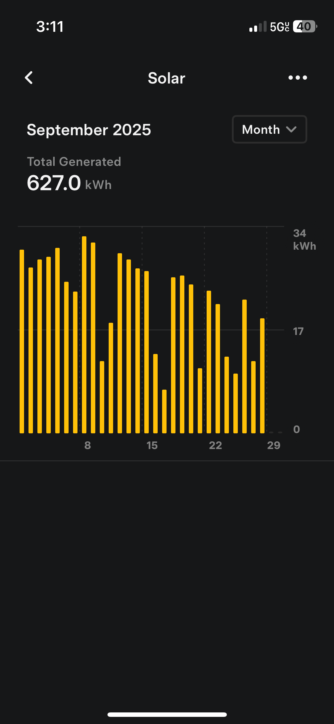
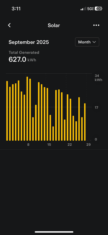
September 2025 OBS-Discussion centered NYC subforum
SACRUS replied to wdrag's topic in New York City Metro
86 / 61 -
Something’s changing even though it’s still 80 damn degrees out
-
It’s a close battle between the chiefs and Steelers as to which team has the biggest Golden Horseshoe up their asses. Difference is for the Steelers, it falls apart in the playoffs.
- Today
-
Backups in at 3 of the 5 OL positions plus Carson Wentz is not a recipe for a winning team.
-
It is absolutely gorgeous outside at 79/54. Probably the best temperature you can get for outside anything ha.
-
Torch day
-

September 2025 OBS-Discussion centered NYC subforum
donsutherland1 replied to wdrag's topic in New York City Metro
Newark has now reached 86°. The last time Newark had at least five days with highs of 86° or above during the second half of September was 2019. In addition, Islip has reached 82°. That breaks the daily record of 80° from 2015. Newark has reached 88°, which breaks the daily mark of 87° from 2014. -
What a torch last week and next 2 days 85 BDL today
-
@mappy https://eos.org/articles/new-usgs-map-offers-an-interactive-look-at-the-rocks-beneath-our-feet I think you might like this
-

E PA/NJ/DE Autumn 2025 Obs/Discussion
RedSky replied to PhiEaglesfan712's topic in Philadelphia Region
Trace yesterday -
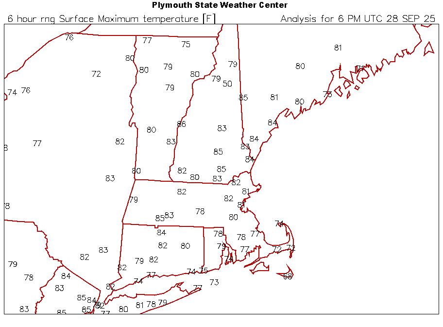
BULLETIN Tropical Storm Imelda Intermediate Advisory Number 8A NWS National Hurricane Center Miami FL AL092025 200 PM EDT Sun Sep 28 2025 ...DEPRESSION BECOMES TROPICAL STORM IMELDA... ...TROPICAL STORM CONDITIONS EXPECTED OVER THE CENTRAL AND NORTHWESTERN BAHAMAS THIS AFTERNOON AND EVENING... SUMMARY OF 200 PM EDT...1800 UTC...INFORMATION ---------------------------------------------- LOCATION...23.9N 77.3W ABOUT 95 MI...155 KM WNW OF THE CENTRAL BAHAMAS ABOUT 370 MI...600 KM SE OF CAPE CANAVERAL FLORIDA MAXIMUM SUSTAINED WINDS...40 MPH...65 KM/H PRESENT MOVEMENT...N OR 355 DEGREES AT 7 MPH...11 KM/H MINIMUM CENTRAL PRESSURE...998 MB...29.47 INCHES @WxWatcher007