All Activity
- Past hour
-
No. LOL!
-

Feb 22nd/23rd "There's no way..." Obs Thread
psuhoffman replied to Maestrobjwa's topic in Mid Atlantic
I was being honest. I never would have even gone 5-10. I was thinking 4-8 and I’d be dropping it right now to 3-7 maybe not increasing it. I honestly want to know what went into their decision. Maybe I’m missing something and I can learn. -

Blizzard of 2026 Storm Thread/OBS
Ralph Wiggum replied to Mikeymac5306's topic in Philadelphia Region
Satellite hallucination warning....loop it an stay focused on the western portion of the low. Looks like its getting tugged west. Probably just the 'eye' expanding but cool loop anyway. -
They have pills for that I think
-
Just 20 minutes since my last post, Snow is picked up and intensity and starting to accumulate more substantially on the grass and starting on the paved surfaces. Trying to nowcast this is still difficult looking at the radar. .
-
.KEY MESSAGE 2... Strengthening E-NE winds today into tonight could produce a surge of 2.5-3.5 ft, producing widespread moderate to locally major coastal flooding along the back bays of western Suffolk and srn Nassau, Peconic Bay, and western Long Island Sound, and widespread minor to locally moderate flooding in NY Harbor and Jamaica Bay, the lower Hudson River, and ern Long Island Sound. The main high tide cycle of concern is Sunday night. Areas of dune erosion are likely, with localized overwashes possible along the ocean beachfront Sunday night into Monday morning. Additional coastal flooding will likely linger into the Monday afternoon high tide cycle, with a strong northerly flow limiting impacts somewhat to minor/locally moderate categories. .KEY MESSAGE 3...
-
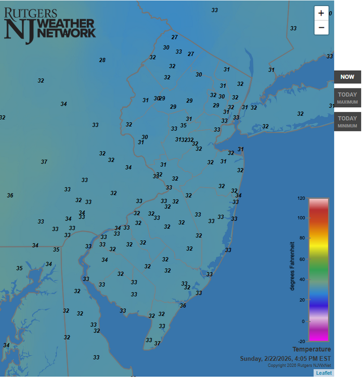
The 32 F isotherm line has rapidly plunged well south into southern New Jersey.
-
Cars, grass starting to see accumulations in Bay Shore, snowing between light and moderate right now I’d say
-
Yah and the shit storm that followed slowly stopped this effort over the years to the point that towns either put pressure on them to scale it way back or stop all together. Three towns near me are so overgrown that i expect at least 40% outage rate, double the normal rate. We haven't had a really good tree clearing storm in a while
-

Feb 22nd/23rd "There's no way..." Obs Thread
Wonderdog replied to Maestrobjwa's topic in Mid Atlantic
Snow sticking in Gainesville. -
Just think how lucky you’ll be tomorrow when you can simply use a broom to brush away your light accumulation while the rest of us are digging out from feet of snow.
-
the storm hasn’t even started yet. come on everyone: get it together.
-

Feb 22nd/23rd "There's no way..." Obs Thread
87storms replied to Maestrobjwa's topic in Mid Atlantic
Thought it was gonna be a full flip here, but once I got below 500’ and then back home it’s still like a 50/50 mix. Very rate and elevation dependent event so far. -

Feb 22nd/23rd "There's no way..." Obs Thread
nw baltimore wx replied to Maestrobjwa's topic in Mid Atlantic
Steady, straight-down, falling snow here. -

Feb 22nd/23rd "There's no way..." Obs Thread
North Balti Zen replied to Maestrobjwa's topic in Mid Atlantic
Sticking to the grass already in fallston -
-
31.1 just need heavier precip and it’s on
-

Feb 22nd/23rd "There's no way..." Obs Thread
NorthArlington101 replied to Maestrobjwa's topic in Mid Atlantic
I’m expecting a 2hr delay with liberal leave -
Coming down nicely here, 35F. A coating plus, even parts of the driveway starting to cave. Nice to get some reinforcements for the snowpack remnant!
.jpg.3d35ba9de4ab1e32baa0ff214288f24a.jpg)
-
-

Feb 22nd/23rd "There's no way..." Obs Thread
MDphotog replied to Maestrobjwa's topic in Mid Atlantic
I know, but the radar edge is getting really close now. It might start back building in. There is some more snow that just popped up pushing west near Chambersburg. We shall see. -

Central PA Winter 25/26 Discussion and Obs
Ruin replied to MAG5035's topic in Upstate New York/Pennsylvania
yes I have just recently in fact the big snow we had this year. -

Central PA Winter 25/26 Discussion and Obs
Blizzard of 93 replied to MAG5035's topic in Upstate New York/Pennsylvania
It is remarkable in all of the wrong ways, lol! -

Feb 22nd/23rd "There's no way..." Obs Thread
DDweatherman replied to Maestrobjwa's topic in Mid Atlantic
I am pretty optimistic that the over will hit now that the initial norlun might set up just west of us. -

Feb 22nd/23rd "There's no way..." Obs Thread
snowmagnet replied to Maestrobjwa's topic in Mid Atlantic
Western Fairfax/Herndon - it's been snowing pretty heavily for the last 30 minutes at least. Deck caving....


