All Activity
- Past hour
-

E PA/NJ/DE Autumn 2026 Obs/Discussion
Hurricane Agnes replied to PhiEaglesfan712's topic in Philadelphia Region
A double hit in 6 years by a storm named Isaias! Got up to 71 after a low of 48. Currently 62 with dp 53. -
I can guarantee that methuen would cease to exist if #15 verified...
-
I bought an extra cord of wood, since I ran out last winter and I refuse to use any oil this winter...bank on a way above average winter this time around. My lack of elevation where I live will pretty much cancel most of the snow this winter, especially if most storms end up borderline temp wise.
-
To get out of Jersey????
-
I’ll say it is certainly increasing and foliage traffic seems to be getting worse and worse. Last weekend and this weekend are Stowe’s busiest of the entire year. Like driving from Exit 10 in Waterbury to Stowe and the general area is almost impossible these weekends. It jacks up even on I-89 just to get off the exits. The Whites and I-93 seem similar from what I’ve seen. People go nuts for it… but there are colorful leaves everywhere. It is interesting to me that there are tons of NNE towns and roads with great foliage, but the people just keep pouring into the same areas. All that said, the mountain vistas are hard to beat with peak foliage. It can seem almost like a religious experience when timed right.
-
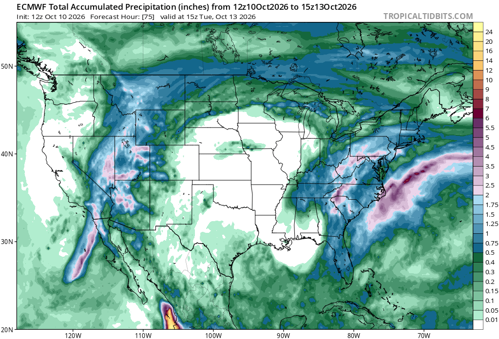
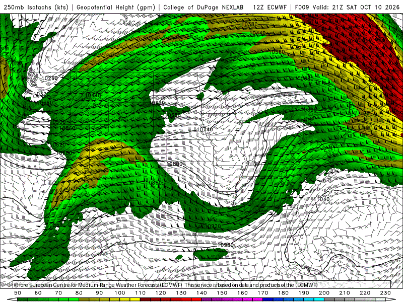
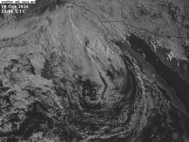
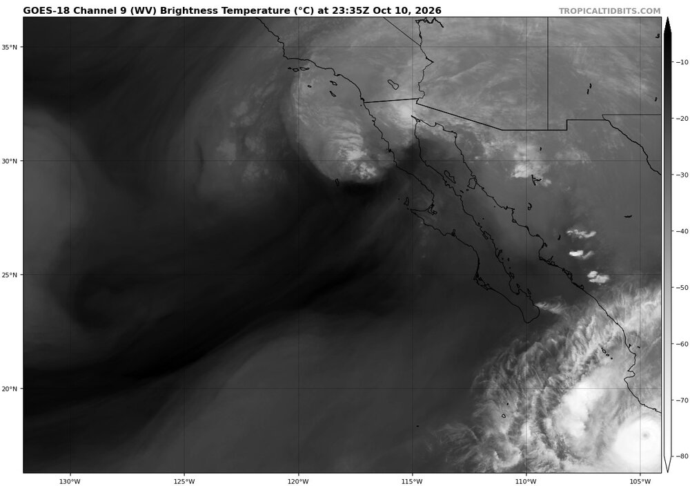
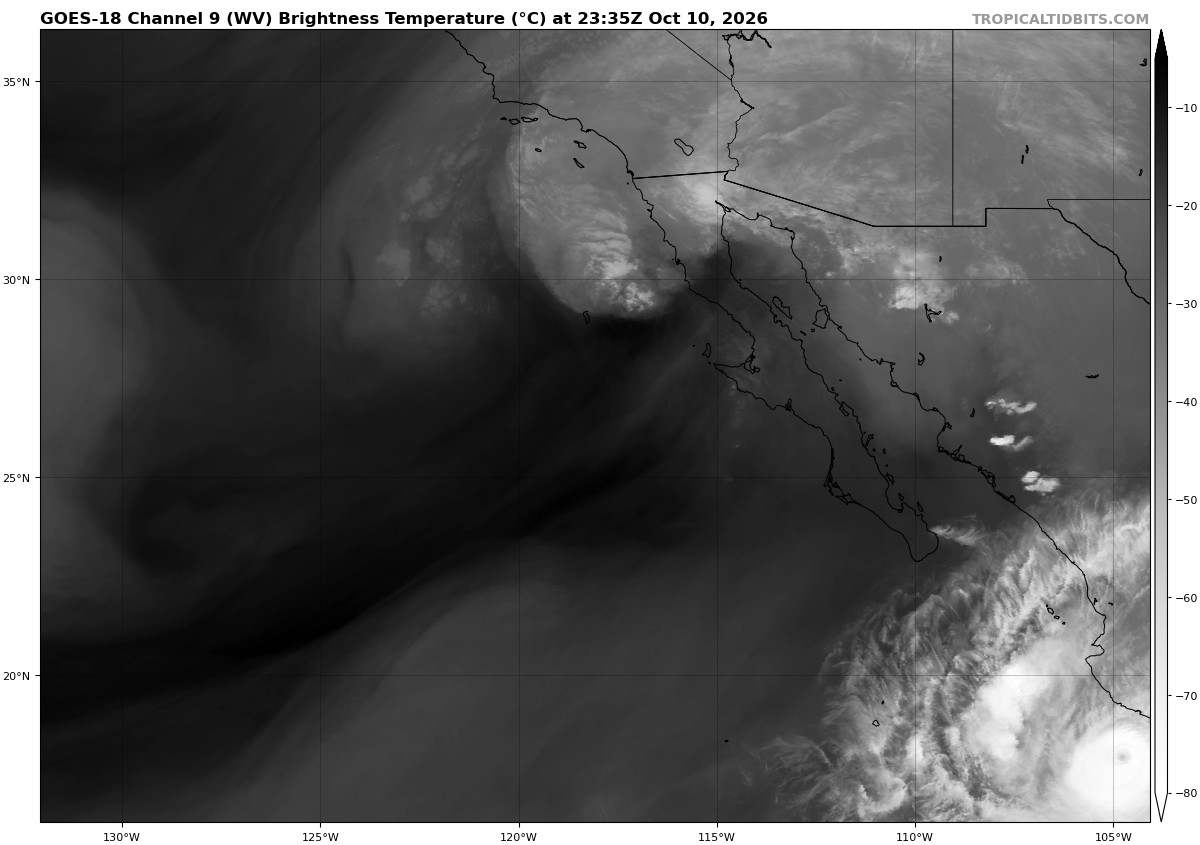
TS Rachel off Baja CA clearly post-tropical. Let me put it this way, if Rachel is still a TC, then Sandy was a TC at landfall. You can't have it both ways from an objective meteorological POV. The fact that rather strong winds and there is a TS watch up for srn CA is irrelevant as to what it is. And there are many winters where srn CA and nrn Baja get gale force winds and a lot more heavy rain than Rachel will produce here, so it not like they are not used to such conditions that are just like a TS. The evidence is solid. The intensity of the system is being driven by fast forward motion, a strong baroclinic trough interaction, and its proximity to the favorable RRQ of a 250 mb jet streak Winds over the system at 250 are 70-80 kt (ECMWF 250 forecast VT 10/21z attached) and the 10/18z SHIPS output diagnosed 700-500 RH of 36%. Frontal structure is apparent SE of the center (VIS image attached). Deep convection is lacking and the moderately cold cloud tops NE of the center are mid or upper level wave cloud ripples typically seen with turbulence from a jet streak (see WV image attached). Unlike Isaias' transition process right near landfall and its much better retention of tropical characteristics, esp. when it came to a large area of very cold cloud tops, Rachel's status now from an objective meteorological standpoint is post-tropical.
-
If you look at model guidance it’s where it’s supposed to be at. The rain shield really develops after 2am
-
Could be an interesting night. I had what I thought was a brief break per radar but no, it was still pouring. That’s what 2” PWATS will do.
-
Probably some torrential downpours to get us to those totals.
-
I’ve always wondered why people feel the need to travel to look at foliage . Most of the travelers get foliage in their areas. It’s never made sense to me. Seems like an excuse to go somewhere that is not really necessary . Like why would someone from NJ or CT need to drive to VT to see trees?
-
Hope the AI guidance is right. Radar and upstream observations certainly aren't encouraging.
-
Yeah I think it’s a fine foliage weekend with the 3-day weekend… there’s plenty of great foliage in New England, you just gotta go to the right places. I know the Lake Placid, Stowe/Mad River Valley and Bretton Woods/MWN/Mt Washington Hotel and neighboring notches are often blasted with social media starting like 2-3 weeks ago. By the time folks see those photos it’s time to go like the next day, not in a couple weeks. I agree there’s a lag there that throws people off. If I was going this time of year maybe the Maine coast to like northern SNE or southern CNE (however you want to call it) would be the latitude band most likely to be peaking. Though to be honest, I have no idea how it is in Lakes Region and Monadnocks over to Berkshires right now. But if you are seeing good pics from a place two weeks before this weekend, it’s too late by now.
-
Eps (top) and Eps Aifs hold strong.
.thumb.png.9c72c93b5b7a5b6620cf8ad006f594dc.png)
.thumb.png.0dc5b97ef68e7caef83bef4738b85eae.png)
-
If they came to NE or NW CT hills they’d have seen much more color this weekend . About 7 days till peak . Thankfully they don’t
-
Heaviest rain of the day, closing in on 2" here. The air has a different feel to it too, has definitely went more tropical the past hour.
-

2026-2027 Record-breaking El Nino
LakePaste25 replied to Stormchaserchuck1's topic in Weather Forecasting and Discussion
Rainfall in the SW from tropical remnants while another system goes up the East coast. Certainly El Niño like regardless of whether the H5 out in the N pacific matches, and the C3S and Euro seasonal hinted at this precip. pattern for the fall.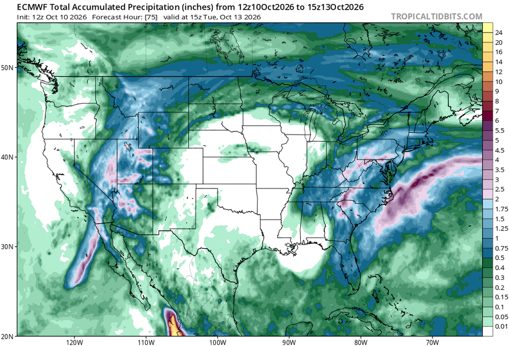
-
People get locked on that weekend for convenience and I feel like it's sometimes marketed that way for business/tourism. Also, the foliage reports tend to run behind real conditions with some of their reporting. Columbus Day is usually more a CNE down to SNE high terrain deal. Even the highest terrain CNE can be past peak.
-
The record was indeed tied today, impressive stuff.
-

2026-2027 Record-breaking El Nino
cmillzz replied to Stormchaserchuck1's topic in Weather Forecasting and Discussion
looks manic tbh -
I’m at the sea coast, in the Pope’s hood, and there is still quite a bit of green.
-
People are sleeping on what could be the first snowfall event of the season for parts of our subforum next weekend! Both the CMC, GFS, GFS AI, and GFS/CMC model ens are on board for accumulating snow for the ridges in WV, though the Euro hasn't bought on yet. The setup makes sense, a strong early season trough will spur upslope snow showers after the front passage with some aid from the Great Lakes. Currently, this is forecasted to take place during the night too which helps with thermals, though the GFS has them bottom out in the mid 20s so there's some room for front timing. Of course, this is still far out in the future and a weaker frontal passage, more progressive trough, or any number of factors could ruin the setup, but it's worth paying attention to for an early snow chase to see both fall foliage in the valleys and snow at the peaks.
-
Yeah, I hit 59° the other day and turned the heat on to 64°
-
It was still a top 10 warmest September for Chicago in spite of that, though obviously aided by the first four days of the month, which were a complete blowtorch.
-
Eastern area posters would retire from this hobby if that verified
-
It’s the same every year. The holiday weekend is always too late. Dont get me wrong, there’s still color in the valleys but even the mountain valleys look like 50% sticks mixed with the left over oranges. Mountains have that past peak burnt orange look, still something but no where near the fire reds, yellows mixed with green from two weeks ago.










.png.8dad82871a889e89a13db7c0cc580489.png)
.png.afca0605a9896baf06fa523b33c72617.png)