All Activity
- Past hour
-
I’ve seen your set . Now them some boobies . Bra em up
-
The Euro has man boobs now…or better known as Bitch-Tits.
-
Thanks! I’m doing much better. The team at Concord Hospital was outstanding
-
Yeah, all-time October warmth up in those areas this last week with highs near 90° close to the Canadian border. Time Series Summary for MALONE, NY - Month of Oct Click column heading to sort ascending, click again to sort descending. 1 2025 88 21 2 2023 85 0 3 2005 81 0 4 2016 80 0 - 2014 80 0 5 2018 79 0 - 2017 79 0 - 2007 79 0 - 1998 79 0
-

The return of the elusive Nor'easter. Drought buster or bust?
CAPE replied to dailylurker's topic in Mid Atlantic
From latest Mount Holly AFD- Latest deterministic model guidance has trended weaker and east with a more elongated low pressure system compared to previous forecasts. What this means is that the QPF forecast has been lowered. Even with this current trend, coastal impacts are still expected to be significant. Also, with these run to run variations of the deterministic guidance, it is important to look at the ensembles guidance which does still have both outcomes of a stronger and more west placement of the low along with the weaker eastward low. Due to this spread and uncertainty, not too many changes were made overall aside from the QPF forecast. Guidance will likely continue to struggle and vary from run to run with this system until it actually forms a well defined low pressure center sometime today or tonight. This is pretty notable on the 0z EPS, resulting in decent precip extending further inland on the mean. -

E PA/NJ/DE Autumn 2025 Obs/Discussion
Kevin Reilly replied to PhiEaglesfan712's topic in Philadelphia Region
Models are really backing off. Weaker storm almost looks like it splits in 2. -
 Nws extended the high wind watches
 -

The return of the elusive Nor'easter. Drought buster or bust?
snowfan replied to dailylurker's topic in Mid Atlantic
I only wanted enough to see the ground white, not enough to shovel -
The return of the elusive Nor'easter. Drought buster or bust?
snowfan replied to dailylurker's topic in Mid Atlantic
6Z HRRR and NAM still drop a general .5 to 1”+ for much of the area east of 15. -
-
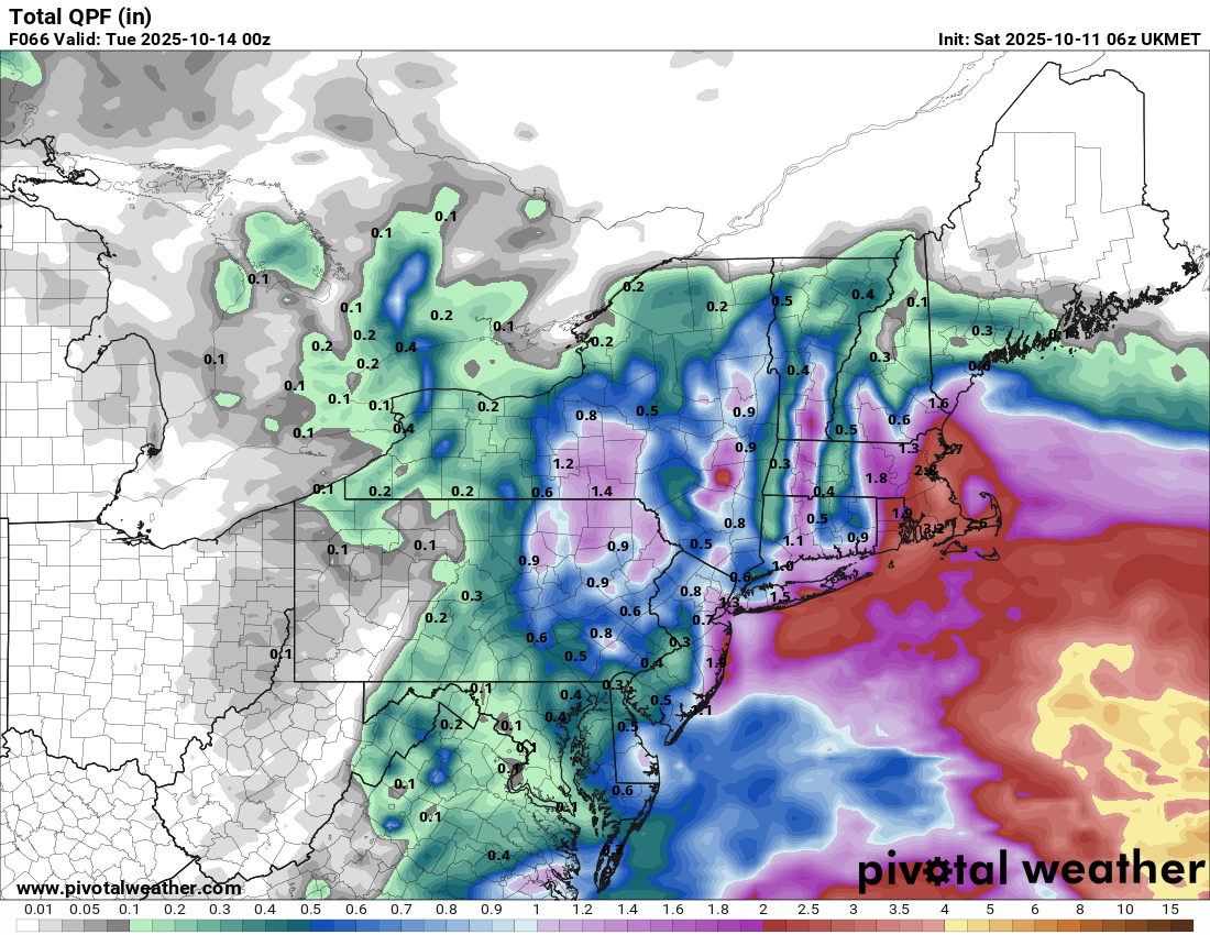
 Pretty decent shift on the 6z UKMET:
-

"Potentially" powerful Nor'easter Sun-Mon 10/12-13/25 with needed rain-especially south of I84, and fairly high impact sct coastal gusts 50+ MPH and possibly moderate or greater coastal flooding at the midday Sun and Monday high tide cycles.
HeadInTheClouds replied to wdrag's topic in New York City Metro
You know winter is coming when you say a potential storm could be significant and get weenied by Snowman. Some things never change.- 237 replies
-
- 1
-

-
- heavy rain
- damaging wind
- (and 2 more)
-
Euro flapping around like Kevin’s boobs on a morning jog.
-
Euro was pretty bad on CT coast.
-

The return of the elusive Nor'easter. Drought buster or bust?
WxUSAF replied to dailylurker's topic in Mid Atlantic
This is the part of the winter storm cycle where we all say we never REALLY thought we were getting 1-2’ and it will be nice just to see the grass turn white. - Today
-

The return of the elusive Nor'easter. Drought buster or bust?
dailylurker replied to dailylurker's topic in Mid Atlantic
Looks like "bust". Shocker lol -
 Good Saturday morning everyone, I've no change to thread headline. Too much guidance argues against softening the implied results. Once our most reliable global models say its gone, then I'll grudgingly accept... but am glad to wake up to a modeled decent nor'easter on the way. I've checked latest SREF/BOM/as well as all global ensembles that we often use and am not buying into the weaker eastward Canadian/ICON/UKMET ensembles...though they are within the realm of possibility. Even today... anyone noticing sprinkles out there on LI or the NJ coast now... see radar. It's going to rain later on today in NJ/EPA (iso 0.1-0.2)...not everywhere but this is the first part of the instability burst aloft as PW increases, drawn northward by the sewd moving Great Lakes closed LOW at 5H/7H. Eventually we get a break tonight or tomorrow morning, then the real deal begins Sunday afternoon with max impact risk, I think Monday. Everything stated on p1 of this thread continues. Modeling wavers but overall... beneficial rain is coming with the mesoscale models later today forward helping focus where iso 4" occurs (for now preferably Ocean/Monmouth but it could be anywhere where persistent moderate rain occurs) with general persistent 850MB ELY inflow of 40-maybe 50KT Sunday-Monday.
- 237 replies
-
- 5
-

-

-
- heavy rain
- damaging wind
- (and 2 more)
-
The return of the elusive Nor'easter. Drought buster or bust?
SLPressure replied to dailylurker's topic in Mid Atlantic
A significant change in the model guidance from yesterday is the lack of rapid phasing of the two mid-level cutoffs. Most guidance now show a gradual phasing of the two vort centers, a process that plays out over a two to three day period. As a result, there could now be two surface lows that develop in tandem along the broad frontal/baroclinic zone that stretches from the Carolinas to well off the southern New England coast. This is important for our area as it will displace the strongest winds to east of the Delmarva and also has led to a big decrease in overall rain totals for the area. As a result, we likely see an initial surge of wind and rain moving into the area Sunday morning as the baroclinic zone takes hold across the Mid-Atlantic. The strongest winds are going to occur Sunday morning, gusting around 25-35 mph and up to 35-40 mph along the immediate Western Shore of the Chesapeake. Lesser, but still breezy at times, west of the Blue Ridge with gusts around 20-25 mph. A steady rain overspread the area early Sunday morning and persists through Sunday night. For those west of the Blue Ridge it likely will be a steady drizzle to light rain, with more light to moderate east of the Blue Ridge. Rainfall totals are around half to three quarters of an inch, with 1.00-1.50" along/east of I-95. The wind forecast is lower than what we had yesterday, so probably will not reach Wind Advisory criteria along the Western Shore on Sunday. Cannot rule out some sporadic gusts around 45-50 mph, but the threat for frequent gusts to that level are much lower. Temps struggle to reach the low to mid 60s Sunday. -
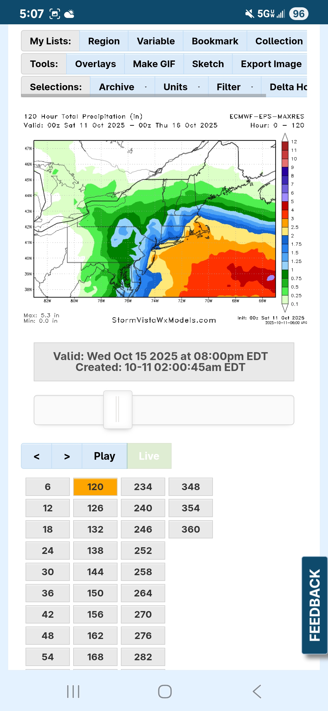
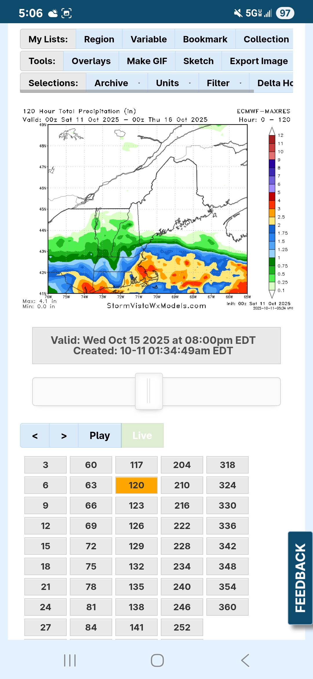
Everything else looks about an inch to an inch and a half?
-
Pretty much the same..
-
How about the other models? I know I could look them up but since you've already been there.
-
6z NAM.and ICON.are pretty robust.. 2 to 3 for many
-
EPS even wetter

-