All Activity
- Past hour
-
It’ll go down faster than Spinks vs Tyson
-
Sleet falling here
-
Warmer more humid air and nights well above freezing. Goodbye.
-
That’s because you’re 98lbs.
-
Here we go….the two monsters are wearing off…and we have this BS from you back. First off, could be record heat next week, then we look to snap back to a full blown winter pattern afterwards…. What’s crappy about that? You’re the only one saying anything like this….par for the course from you.
-
I can stand on top of the pack here. Lots of ice in it. It’ll go next week but it will fight . There’s 13-15” depth depending
-
Maybe by 2030
-
Ice storm warnings?
-
Yes, you can use it.
-

Central PA Winter 25/26 Discussion and Obs
pawatch replied to MAG5035's topic in Upstate New York/Pennsylvania
31 degrees and freezing stuff. Good day to sit inside and drink coffee. -
I’ll give it a D+ here. We received accumulating snow 3x and twice my road was covered for more than a day. The extended cold and snow/sleet cover for nearly two weeks was nice too. Now the negatives… All 3 systems underperformed in my backyard. Though the ice storm thankfully wasn’t ice it was cold enough for an awesome sleet event like the triad and western areas saw but we didn’t even get 1/3 of the predicted QPF and ended up with about 3/4” of sleet. The snow hole was the most brutal radar watching of my entire life, if you didn’t live through that in the triangle area you don’t know the pain we went through. Yes it snowed but we got literally the lowest total in the entire state and it didn’t start till well after dark. Speaking of after dark, not a single event produced accumulating snow or sleet in daylight. The December system was all after dark, the “ice” storm was almost entirely Saturday morning before light, all day was dry without precip until the last band came through after dark, and the Jan 31 was essentially 7 pm-12 am here. Our total snow for the season was 3.6” which is 2” below normal and I think we were the only spot in NC that didn’t hit climo. That in itself could be a failing grade but I’ll give the 3 systems, 2 cold ones, and extended cold “some” credit but it feels like an F given the rest of the region. We were above climo last year at my house. Also, the Christmas torch was brutal as was the first half of January.
-

Pittsburgh/Western PA WINTER ‘25/‘26
EVLINC64 replied to Burghblizz's topic in Upstate New York/Pennsylvania
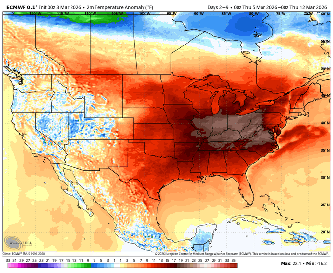
The American Storm @BigJoeBastardi · 12m Weatherbellians and you, if you have watched some of the tweets, have seen me say "beware the ides of March" for another flip to colder. Well models are seeing it. After one of the warmest front 10 days of March, look where we are by the 15th. Do not be surprised as this pattern evolves that the first 10 days or so of April are as cold in the areas that are that warm in the first 10 days of March.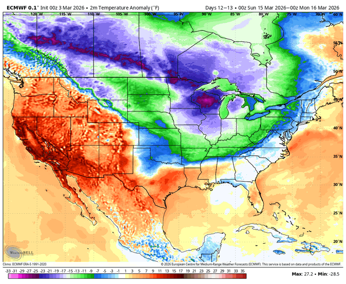
-
Another A+ here. Below normal temps for January and most of February plus an incredible 18" of snow and near blizzard conditions along with possibly the lowest temp I have recorded in decades at 11°. What a winter.
-
here too-we are not geting 1/4 of an inch of ZR lol
-
It’s icy out this way. Sleet/freezing rain mix. Salt trucks are out. 28 degrees. Per my wife’s co-worker (who lives near Ogdensburg) Sussex County has schools closed.
-
Between 7-8 inches here in north facing areas, grass in the south facing hills
-
Kind of a crappy look for the next few weeks. Parade of weak shortwaves with showers every other day
-

Winter 2025-26 Medium/Long Range Discussion
A-L-E-K replied to michsnowfreak's topic in Lakes/Ohio Valley
the cad that follows is gonna really sting huh -
Snow to start maybe a touch or ZR but should rot at 32.5 for awhile
-
3k is probably more realistic
-

Outta gas and Outta Time: Early March Winter Storm finale
Eskimo Joe replied to Ji's topic in Mid Atlantic
M0.5" storm total snowfall, M0.05" storm total zr, Reisterstown. -
Without any advection or lower Td air I doubt we’ll have accretion levels like that.
-
Yeah, we rain
-
We plain rain here
-
May need to sell that here


