All Activity
- Past hour
-
It would’ve been called nor’easter in the yore years. Heavy snow and strong NE winds.
-
Northof78 already opened one a while ago
-
Don can explain in more depth than me but from what i understand they reported 19.7" at 1PM when it was still snowing for a couple hours after that and never updated the snowfall total. Apparently there was an additional 0.15" qpf after the report. This is what i saw on the NYC forums anyway.
-

"Don’t do it" 2026 Blizzard obs, updates and pictures.
Ginx snewx replied to Ginx snewx's topic in New England
Plainfield -
Ya, that(Jan 25th) was a monster SWFE…one for the record books..not a Nor’easter.
-
Don't see any big prolonged torch in the cards with this happening. Even though I'm more than ready for one lol. Luckily, I'm going to the Bahamas on the 11th. So you can probably lock in a March biggie for that week This will probably want to keep the vortex hanging out near Hudson bay. Which has been a preferred locale for it all winter long already. I'm not exactly getting early summer vibes from that idea.
-

2/24 - 2/25 Clipper Obs (1 - 2" for many on forum)
WeatherGeek2025 replied to Northof78's topic in New York City Metro
anyone follow my instagram page? @nycweathernow -
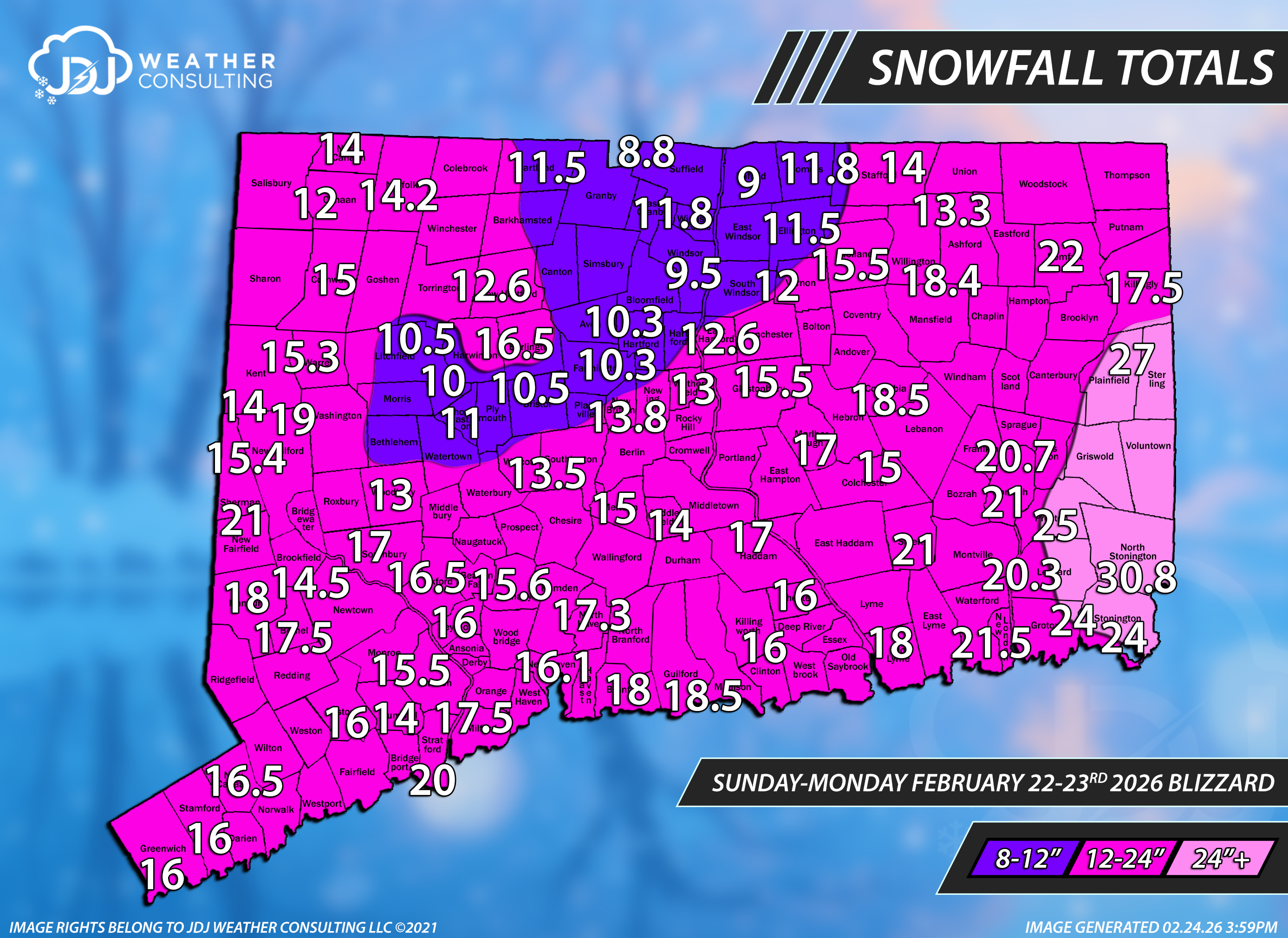
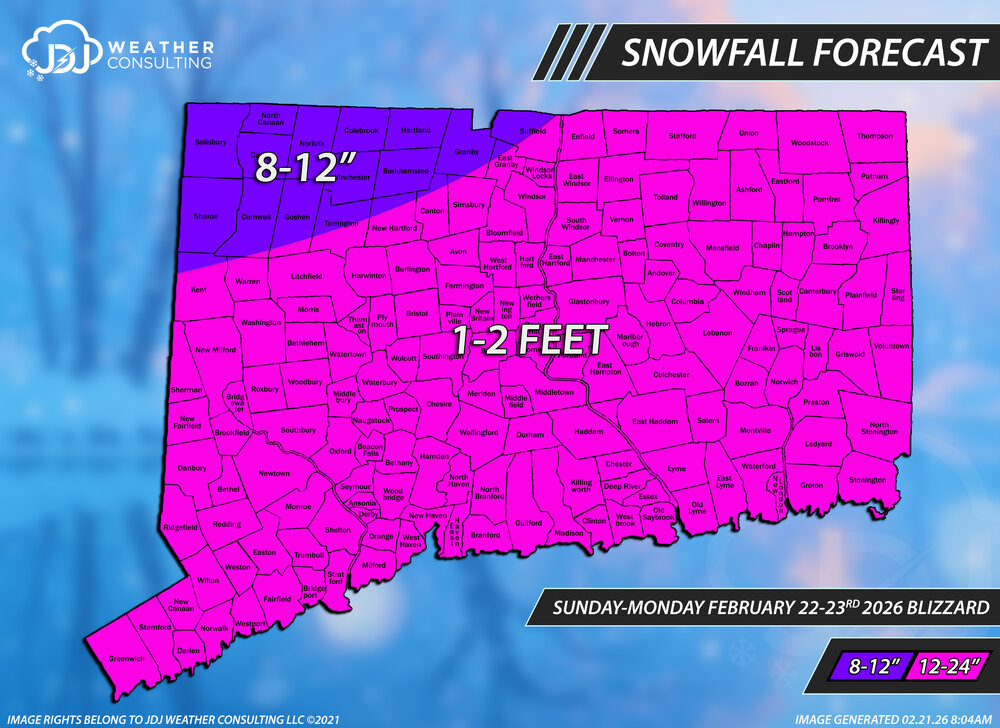
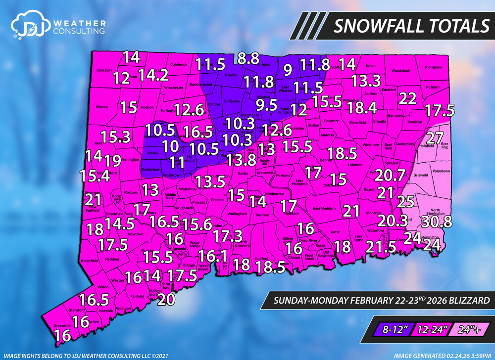
This is a first pass - initial snowfall totals for CT only. Will be working on SNE/Tri-State for the next couple days, it's going to be quite a project to say the least. Thanks to everyone who sent reports, i tried to use most of them if i could fit them in. This CT one will get updated with different ranges but used the original ones for verification purposes. Overall feel very good about the final call forecast, at least for Connecticut. Some higher amounts greater than 2 feet occurred in SE New London and eastern Windham counties. Feeling an A- for the grade for CT.
-

Clipper Fires In Wednesday Feb 25 Disco/ Obs
WinterWolf replied to Damage In Tolland's topic in New England
Already got an email saying be ready for delays, and hopefully not closures. -
Well, Canadian gives you twice mby, Euro gives me 3.3" and you 2.4". It's really the Gfs with the great disparity, and it's fair to say, that ain't holding for 7 days this winter. Could be congrats Chill ultimately.
-
I’m even more speechless than yesterday! For Mar 7th, the mean has plunged from +20 with only 2% reversing around then a mere 5 runs ago to -11 and 100% reversing on today’s!! Again, I’ve never seen anything anywhere close to this before.
-
Clipper Fires In Wednesday Feb 25 Disco/ Obs
WinterWolf replied to Damage In Tolland's topic in New England
You’re a meteorologist …e-mail em and tell them they are wrong. -
What’s the problem with NYC?
-

February 2026 OBS & Discussion
donsutherland1 replied to Stormlover74's topic in New York City Metro
Tomorrow will be somewhat milder with some early snow showers. Parts of the region could see a fresh coating of snow. A period of rain or wet snow is possible late Thursday and Thursday night as a system passes to the south of the region. Friday will be a bit colder before it turns milder on Saturday to start the weekend. Winter 2025-2026 will is on track to join Winters 1960-1961 and 1977-1978 as the only winters with two or more 10" snowstorms, a seasonal mean temperature of 32° or below and seasonal snowfall of 40.0" or above. The ENSO Region 1+2 anomaly was +1.2°C and the Region 3.4 anomaly was -0.1°C for the week centered around February 11. For the past six weeks, the ENSO Region 1+2 anomaly has averaged +0.37°C and the ENSO Region 3.4 anomaly has averaged -0.32°C. Neutral ENSO conditions have now developed. Neutral ENSO conditions will continue through at least mid-spring. The SOI was +7.16 today. The preliminary Arctic Oscillation (AO) was +0.202 today. Based on sensitivity analysis applied to the latest guidance, there is an implied near 100% probability that New York City will have a cooler than normal February (1991-2020 normal). February will likely finish with a mean temperature near 31.3° (4.6° below normal). Supplemental Information: The projected mean would be 4.0° below the 1981-2010 normal monthly value. Overall, Winter 2025-2026 is on track for a seasonal mean temperature of 31.9°. If a 32.0° or below seasonal mean temperature occurs, that would be the lowest winter mean temperature since Winter 2014-2015 when the mean temperature was 31.7°. Winter 2025-2026 would only become the fourth winter of the 21st century with a mean temperature of 32.0° or below. -
While this is true…he is saying that he feels the warmth will happen(NYC as an example), but it will be short lived.
-
I'll take my 11" and cal it a winter.....
-

"Don’t do it" 2026 Blizzard obs, updates and pictures.
Angus replied to Ginx snewx's topic in New England
We got maybe 13" here in Concord MA and that might be generous. But it was a good storm with wind and drifting. I had to go to Norwell today (think Weymouth/ Hanover/Hingham) no power, street clean up poor. Snow depth is thigh high there. What a mess. -

Central PA Winter 25/26 Discussion and Obs
Voyager replied to MAG5035's topic in Upstate New York/Pennsylvania
I just saw a couple posts on Facebook that nearly pushed me over the edge. Both of them talked about another PV split, and that after a bit of a warmup, winter returns and may last into early April. They actually made me hide all weather posts on Facebook from pro and amateur mets. I can't take the depression any more. I just can't... -

"Don’t do it" 2026 Blizzard obs, updates and pictures.
Superstorm replied to Ginx snewx's topic in New England
Im assuming 27” in Brooklyn, CT . 21” in Ocean Township, NJ where I was during the event. . -
2/24 - 2/25 Clipper Obs (1 - 2" for many on forum)
WeatherGeek2025 replied to Northof78's topic in New York City Metro
i'll take a guess central park records 1.3 inches -
2/24 - 2/25 Clipper Obs (1 - 2" for many on forum)
WeatherGeek2025 replied to Northof78's topic in New York City Metro
oh shoot i opened a thread didn't know there already was one -
Thanks. I will do so. Usually, it takes a few days.
-
"Don’t do it" 2026 Blizzard obs, updates and pictures.
Ginx snewx replied to Ginx snewx's topic in New England
27 you? Very sure as 3 reports within 3 miles all the same -
you are correct, they never updated the plot on the interactive map, i assumed it was right since they are very good about that (BOX). Yes 17.1" is the updated amount Let me know when you hear about NYC, very curious
-

"Don’t do it" 2026 Blizzard obs, updates and pictures.
Winging_it replied to Ginx snewx's topic in New England
Anyone notice that PVD recorded only .69 WE? Combined with 37.9 inches snow, that yields a ratio of > 50:1 ! Something seems off ...