All Activity
- Past hour
-
 I think a wind advisory was warranted
 -

Central PA Fall Discussions and Obs
Itstrainingtime replied to ChescoWx's topic in Upstate New York/Pennsylvania
-

2025 Lawns & Gardens Thread. Making Lawns Great Again
Brewbeer replied to Damage In Tolland's topic in New England
put down fertilizer yesterday and winterized the irrigation system last weekend; we've had a couple of solid frosts but no hard freeze yet, hoses and outdoor shower still ready for use and the houseplants are still outside on the patio (covered for frost) -
 Rainfall 1-2" in NJ except Sussex County and a few spots on the coast 3/4-1". NYC around 0.8 so far except about 1.5 Staten Island.
- 117 replies
-
- 1
-

-
- heavy rain
- damaging wind? squalls?
- (and 2 more)
-

E PA/NJ/DE Autumn 2025 Obs/Discussion
Hurricane Agnes replied to PhiEaglesfan712's topic in Philadelphia Region
Back edge has passed through here and the sun is popping in and out (still some dribs and drabs to the west). Finished up, for the most part, with 1.72" (total 1.94" over 2 days). Currently 65 (my high so far for today) with dp 64. Looks like a convective line formed right in Jersey!
-
 1.4" and pretty much over now.
 -

E PA/NJ/DE Autumn 2025 Obs/Discussion
JTA66 replied to PhiEaglesfan712's topic in Philadelphia Region
2.20"! Yeah, it was puking fatties here for awhile. Temp up to 63F. -
 The wind is ferocious in Queens
 -
I will post a general modeling summary after this event is over going back to the original guidance available Sunday and from CPC a week ago. Initial lessons: GFS max wind gusts too light with EC and NAM gusts better. Let's remember for the future on easterly wind events.
-

E PA/NJ/DE Autumn 2025 Obs/Discussion
Birds~69 replied to PhiEaglesfan712's topic in Philadelphia Region
The steady precip appears to be done w/some spotty stuff lingering. Guessing 1.25" or so. Sun may make a guest appearance before sunset... 63F -
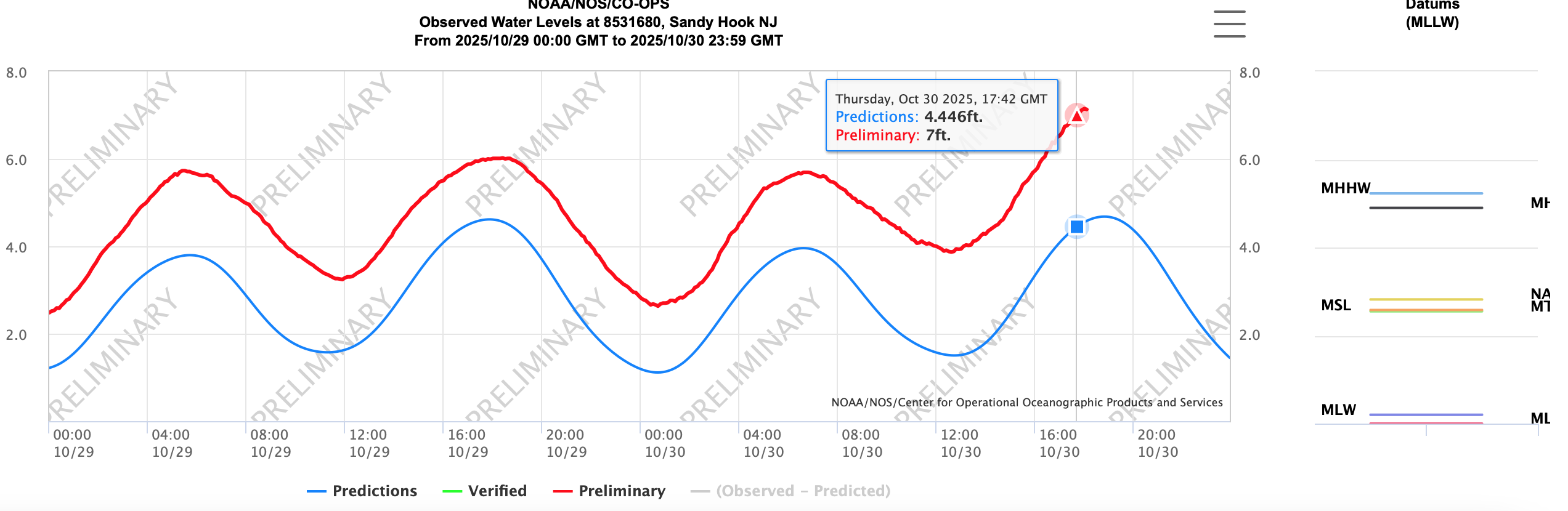
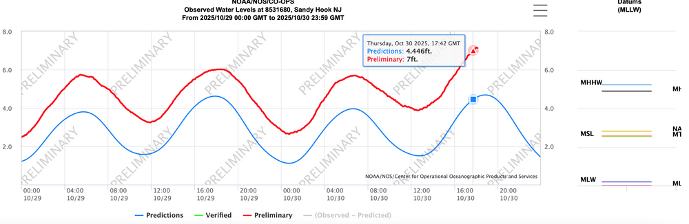
Max gust on NYS mesonet sites about 5-8 MPH less than ASOS max gusts. Officially minor flood at Sandy Hook. FS 6.7". they are at 7.15 bobbing around and may go up and bother 0.3' through there high tide cycle now. Attached... Also 10-13,000 meters without power now in all three states of NJ, NY, PA. Wind related.
-

Spooky Season (October Disco Thread)
WinterWolf replied to Prismshine Productions's topic in New England
First mile brewery. -

Central PA Fall Discussions and Obs
Jns2183 replied to ChescoWx's topic in Upstate New York/Pennsylvania
Someone north of Harrisburg is getting absolutely whacked by this. It blew up fast. Sent from my SM-G970U1 using Tapatalk -
-
 49 mph gust at Great Kills Harbor
 -
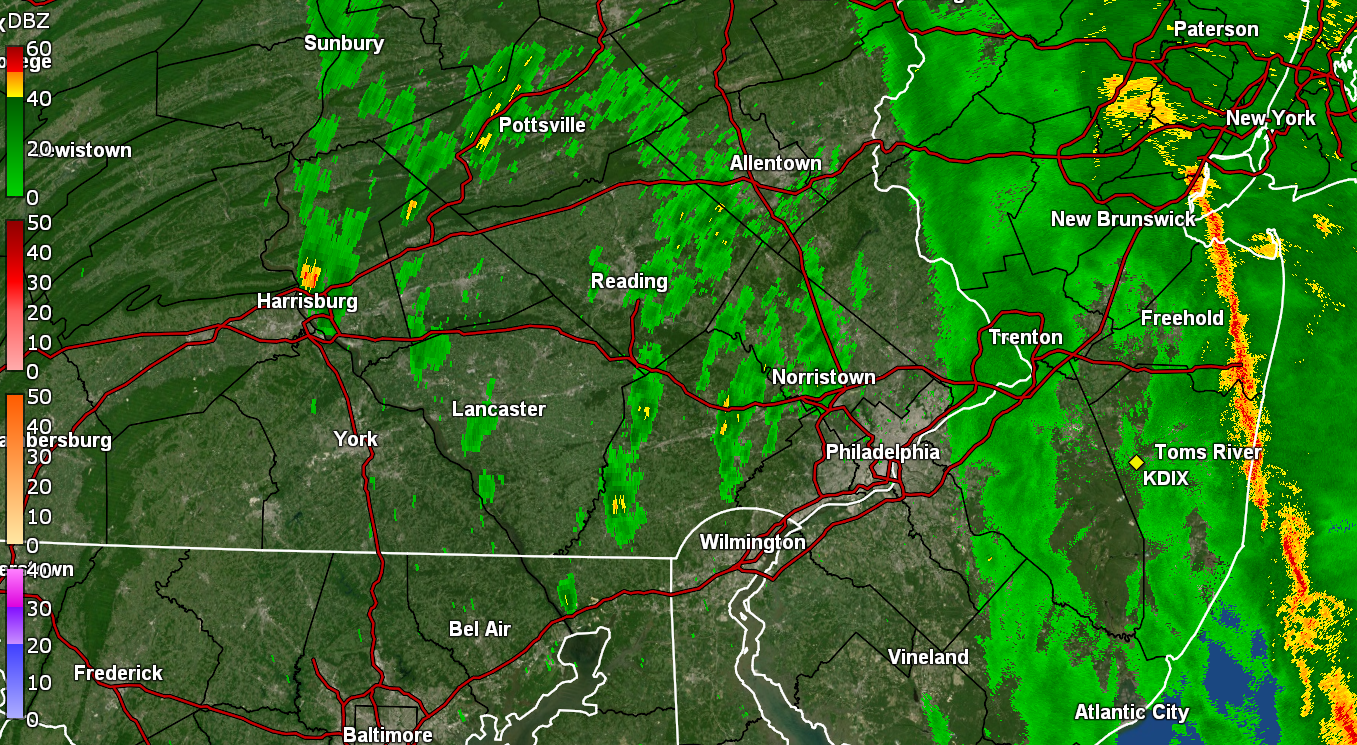
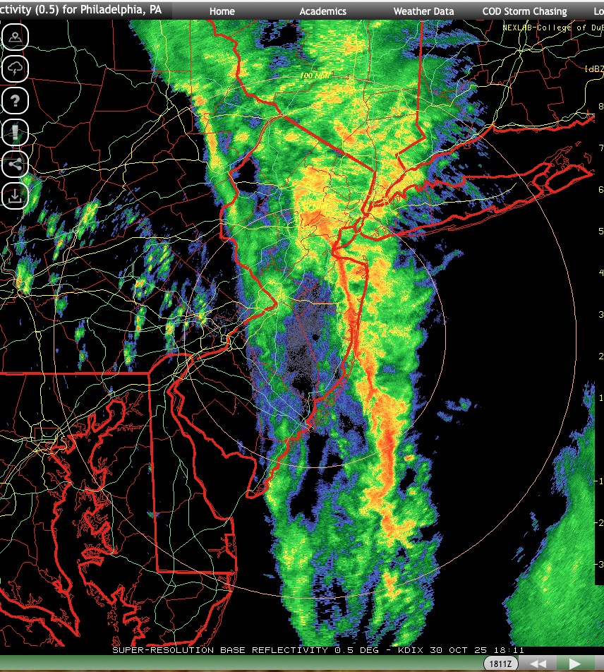
 https://weather.cod.edu/satrad/nexrad/index.php?parms=DIX-N0Q-1-48-100-usa-rad
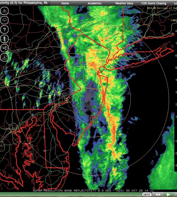
- 117 replies
-
- 1
-
-
- heavy rain
- damaging wind? squalls?
- (and 2 more)
-
 Power just went off then back on. Fairly quickly too weirdly enough
 -
Widespread Gusts on ASOS NYC metro airports 40-46 KT past couple of hours.
- 117 replies
-
- 2
-
-
- heavy rain
- damaging wind? squalls?
- (and 2 more)
-
Cross sound ferry has just suspended all ferry service as of 2 pm
- 117 replies
-
- 1
-

-
- heavy rain
- damaging wind? squalls?
- (and 2 more)
-

E PA/NJ/DE Autumn 2025 Obs/Discussion
BBasile replied to PhiEaglesfan712's topic in Philadelphia Region
Looks like it's gonna be 1.47". Temp is 65F which actually feels kind of warm. -
Central PA Fall Discussions and Obs
Jns2183 replied to ChescoWx's topic in Upstate New York/Pennsylvania
It's dark as hell in midtown. Sent from my SM-G970U1 using Tapatalk -

2025 Lawns & Gardens Thread. Making Lawns Great Again
tamarack replied to Damage In Tolland's topic in New England
Never seen that double notch before. Demos I've watched had the single notch, wrap, and paraffin paint. -
48 mph 155
-
 Absolutely pouring in Mahwah while at store.