All Activity
- Past hour
-
I think the differences are mainly noise on such a forecast product like the weeklies that far out.
-

November 2025 general discussions and probable topic derailings ...
Typhoon Tip replied to Typhoon Tip's topic in New England
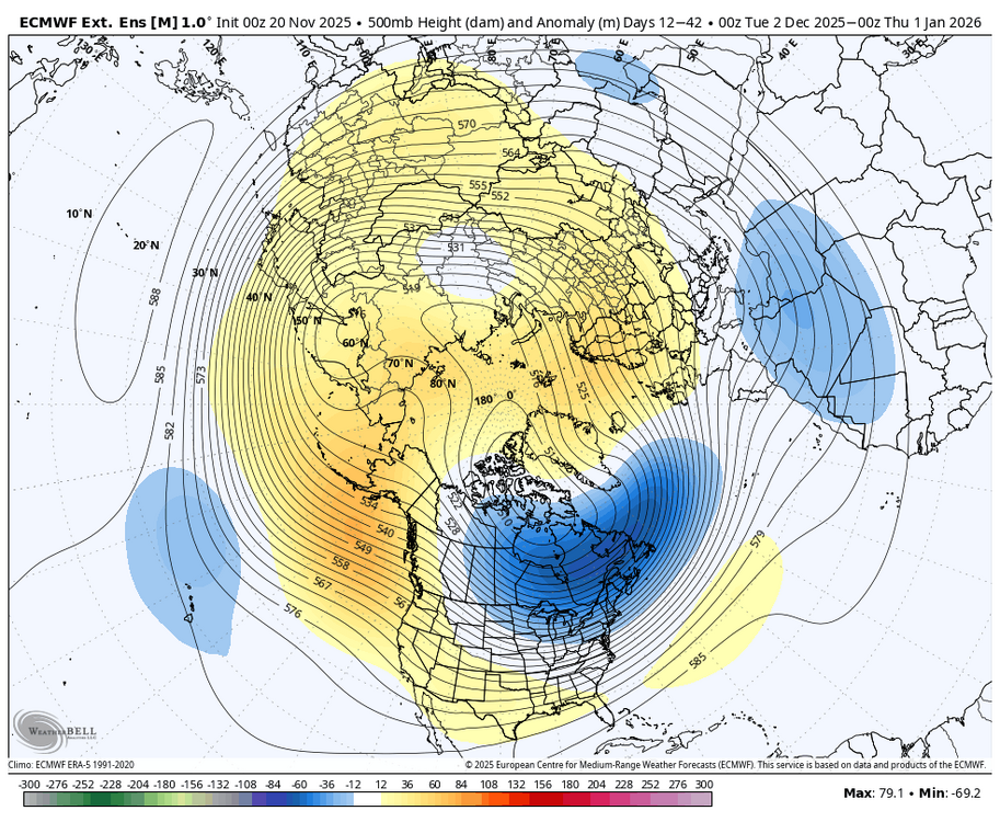
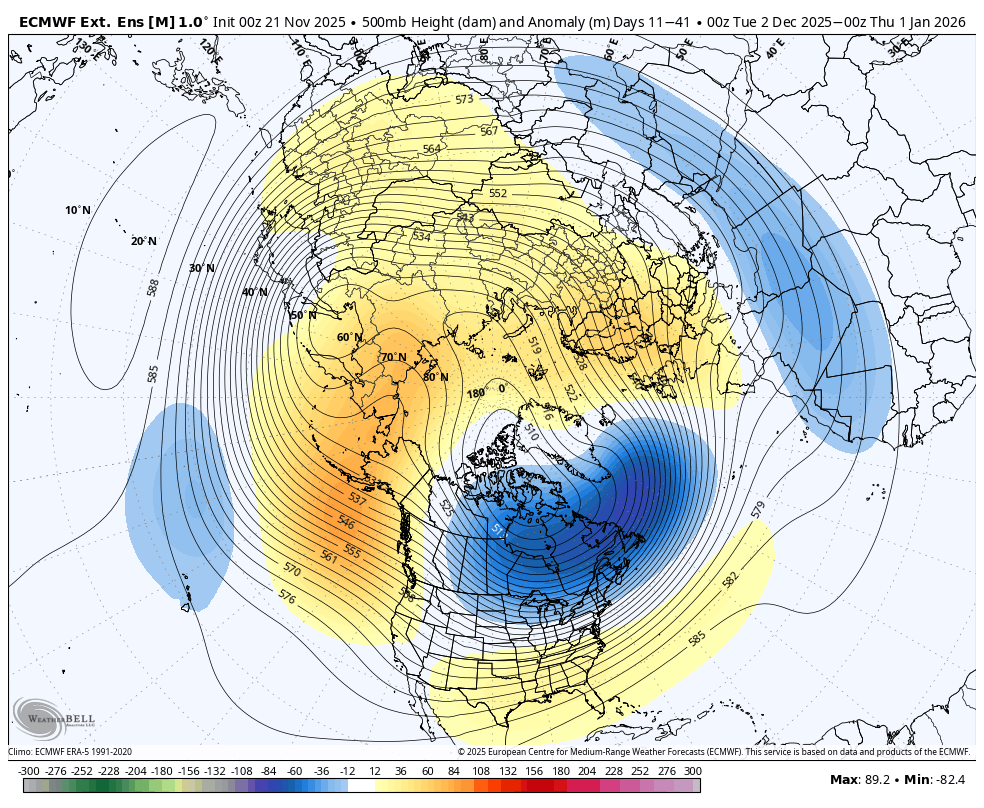
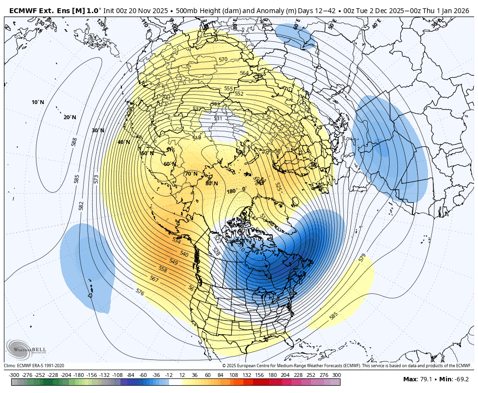
The majority doesn't appear to have this right, anyway. There is no SSW.... there never was yet. There may be one about Dec 7 or so... but antecedent to the -WPO/ -D(EPO) that was not the case. This is a ridging that is emerging from mid to upper troposphere and the tropopausal heights are elevated around the N arc of the ridge at upper levels; that does have an effect on the morphology of the PV. As I explained the other day, it may be splitting hairs? Either way, a -WPO/-EPO arc can arrive into that scenario however it does, when it gets into that mode, we load ... cold air in the winter. The cold you noted in Canada ( 2-meter temp anomalies... and 850...etc), that is a direct result of the activated loading pattern. This is just -WPO/-EPO, nothing else. Not sure why social media can't help itself but go from 0 to sci fi drama with such little excuse to do so - sometimes I suspect it's society dopamine plague since we've become tech zombies. How's that for sci fi. jesus As far as the colder pattern, this is all greater confidence than people are letting on - a lot of which I suspect is not having patience. Part of the problem of visualizing these changes at long leads ... ( over 15 days in some case...), about 5 days in waiting all the doubts start happening ... People expect to see things now. Meanwhile, models will come in and out of the signal ( operational versions). By the way, here's the 360hr 10 hPa GFS prog... this is a warm intrusion - we'll see if it's real.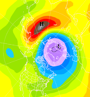
-

2025-2026 ENSO
michsnowfreak replied to 40/70 Benchmark's topic in Weather Forecasting and Discussion
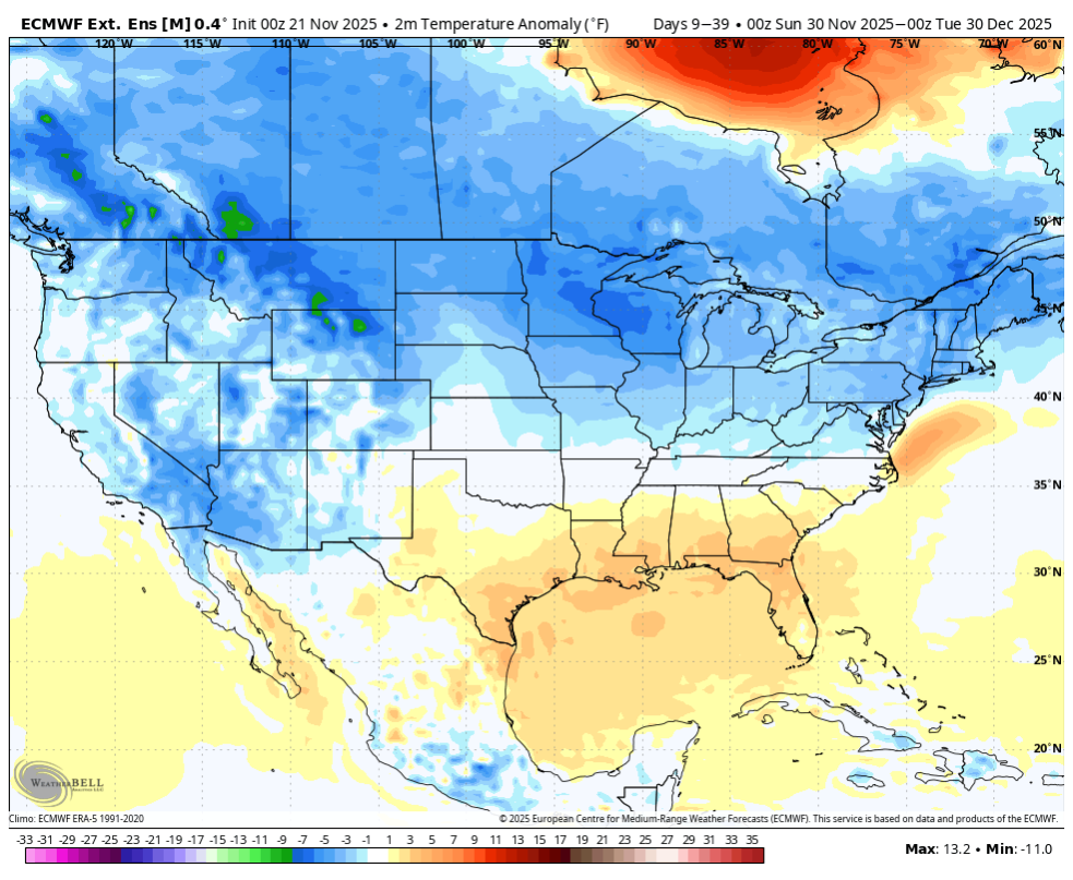
Im sure he was referring to his location. I see no warmth at all in MI in the means. Doesn't mean there won't be a mild day or two. -

November 2025 general discussions and probable topic derailings ...
dendrite replied to Typhoon Tip's topic in New England
-

December 2025 Short/Medium Range Forecast Thread
Carvers Gap replied to John1122's topic in Tennessee Valley
If the Baja/Southwest cutoff is simply feedback, we should start to see the slp slowly creep eastward with each run, especially the first (in a series of 3!). If that is indeed feedback, you can bet the rest of the (previous runs) are probably not correct. Something to watch on this rainy, fall night. -
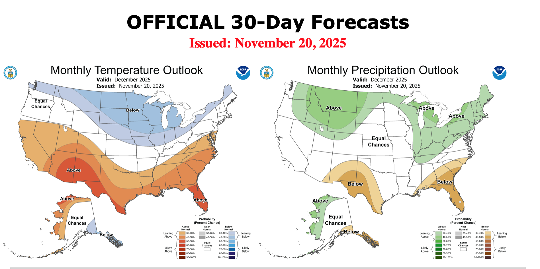
The Weeklies have it mainly mild in the SE first 3 weeks of Dec, not the NE, thanks to a SE ridge. Anthony asked where’s the warmth? The maps he posted had SE warmth.
-
I understand what you're trying to get at, and I agree with you--December isn't looking warm at all, especially for those north of Baltimore. I have no idea where some of those people get that idea from. However, I think it's important to take responsibility, as I thought you had tried to cover up warm trends on the weeklies. Obviously we have our different perspectives as to what happens, but I was just commenting on what I noticed. Winter isn't over at all, because we're still in November, and we have no idea what the end result will be. Nothing is set in stone. So here's to a snowy winter!
-

November 2025 general discussions and probable topic derailings ...
CoastalWx replied to Typhoon Tip's topic in New England
All the whacking to stratospheric wind reverses and weeklies don’t show much NAO ridging. Love it. Gradient flow it is. -
 I was just giving some info from another source... Calm down snappy. ;-)
 -
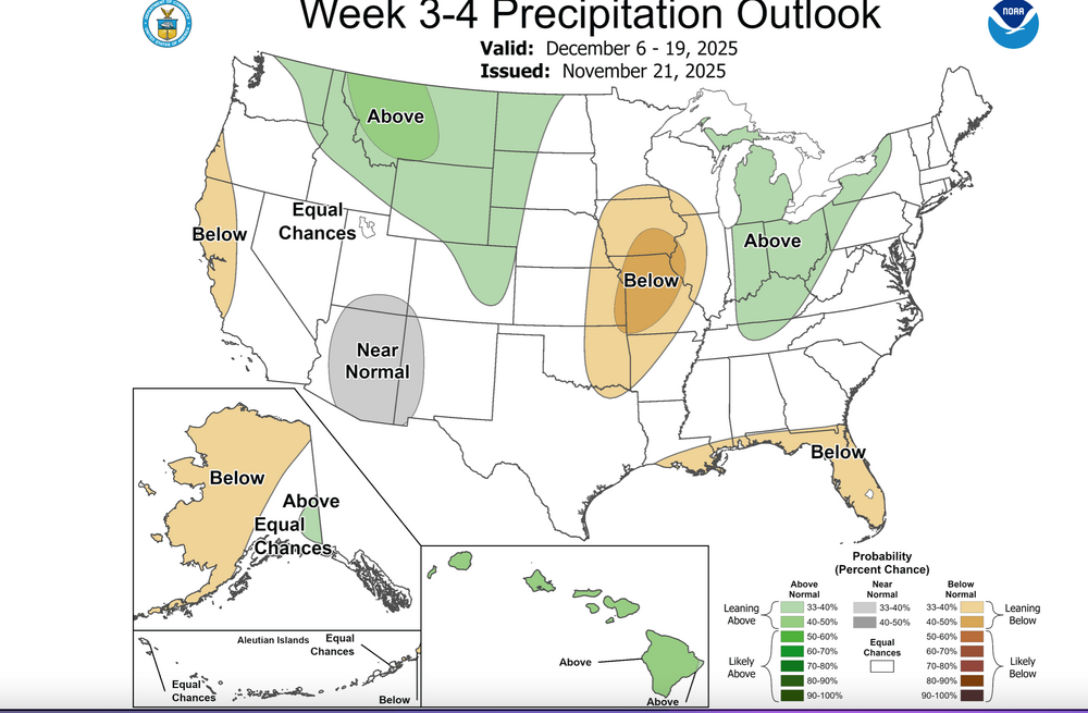
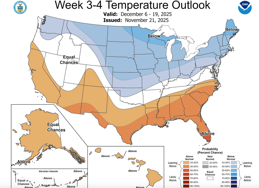
I've appended the week 3-4 CPC Outlook issued 11/21 and the monthly outlook issued 11/20. Click for clarity. There has been discussion of the stratwarm impact on North America In December. I hope I'm very wrong thinking "is that all there is around the NYS subforum?" For now unless the 5H cold core recenters - penetrates significantly further south into Hud Bay (below 60N) or we develop a 'general' +PNA, -NAO in December, its impact here in the northeast may be minimal. I just don't know. Others hereon are more informed. Entire month open to discussion...bring on the snow and lets get off to a good start in CP etc.

- Today
-
The pattern hasn’t even occurred yet and ppl are yelling declaratives
-
I have seen this song and dance many times the past 10 years. 1. Models/weeklies show great pattern weeks away 2. Models/weeklies start delaying or backing off of great pattern 3. Weeks go by and its still at or above average 4. Now its January and the change hasn't really happened. Fab Feb will save us
-
December 2025 Short/Medium Range Forecast Thread
Carvers Gap replied to John1122's topic in Tennessee Valley
The flip has been quick! The trend has not been our friend, but it is only November and we have just begun to fight...or something like that. The pivot away from BN heights over Tenn Valley has voluminous support both in width and depth in the model world. From ensembles to Weeklies....the trend is towards a standing wave SER over the SE. It can be beaten down, but it immediately returns. Outlier models such at the Euro AIFS and GEPS persist. I don't discount those. If cold is coming, the Canadian model will see it first. What we really want to see is the GFS deterministic to start bringing cold eastward OR the Euro control weeklies. That Weeklies Euro control is a nifty tool. With the exception of a few days earlier this week, it simply refused to be cold for December. The repeated troughs into the Southwest are an ominous look if you like snow and cold. I keep asking myself this question, "Have I been burned more by Baja lows which actually formed...OR have I been burned more by modeling which erroneously (due to feedback) put that feature in the Southwest?" I guess we will find out soon! Modeling often performs so poorly over that region. I find it pretty hard to believe that the MJO in phase 8 is going to end up being warm. So, I do think there will be some moderation(from AN heights) back towards seasonal and maybe even BN heights at some point for a 7-10 day period during December. The Euro Weeklies today are cold at the surface, but I now think that is a bad, bad bias(and a new one at that) and an error. Its 500 heights are now pretty much AN for most of December. That would imply cold will push some, but the SER is the base pattern. Again, this is shoulder season, and trends will likely still change - we can hope, right?! However, for me anyway, my hopes that models are delaying the cold diminish with each passing run. The reality is that it might not come to pass for much of December. But it only takes one memorable snowstorm to make folks forget a warm pattern! Besides, we usually don't get a lot of tracking in the valleys until January or Feb. We aren't even gonna talk about the retrograding BN heights(over the HB) into the West to start January! If LR ext modeling was wrong about December cold, it could certainly be wrong about a January pattern at range! I wish I had better news. I will give it a few more days, and then I will almost certainly have to adjust my winter ideas. Have a good weekend, everyone! At least we are getting some much needed rain. -
You have the greatest hits of subjective posters (3 of them) feeding the general pessimism from the others. I mean I get it...typical year on weather forums, lol.
-
Lol not what I would call a SE ridge.. Follow the height lines. One could argue that would produce a more favorable storm track for our area than the previous run, which might tend towards being too far south. The biggest difference is the ridging poking into Greenland, and it isn't really that much different. I pay less attention to the colors on these super LR tools. Look at the height lines and imagine the flow.
-
But its not showing warmth but yet the same people think winter is already over or its going to be warm. No signals at all of warmth for maybe a few days ahead.
-
What are you talking about ? This forum is getting ridiculous. December is below normal on the weeklies.

-
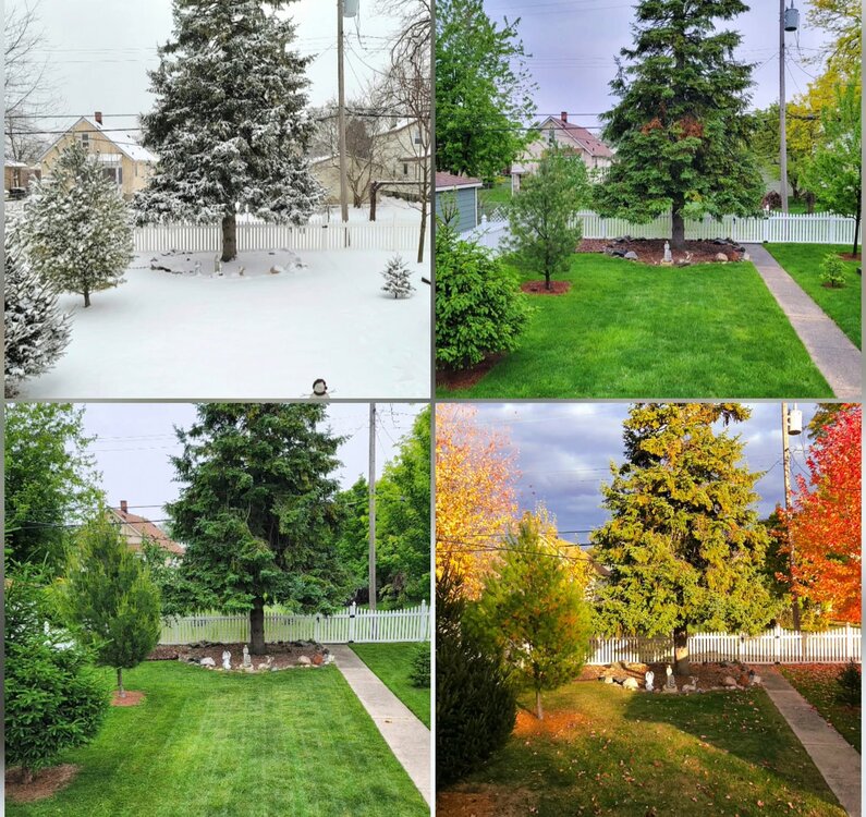
I posted something similar a while ago, but was able to update it with the newest Fall pic. Looking into my backyard. Always feel lucky to have 4 seasons, and it's really neat to see it in a picture form. I didnt have a good spring Pic, had to use one from last May, but now I think I want to do a comparison shot every year.
-
If Simon Lee is correct about 96-97 being a stratospheric analog, then a strengthening SPV into January would fit
-
November 2025 general discussions and probable topic derailings ...
CoastalWx replied to Typhoon Tip's topic in New England
Both progs are really cold in Canada. I see Eduggs is in Jersey so I see why he might be looking for something a little different. I don’t mind being near the battle ground with SE Canada BN in temps. -
December is trending in the wrong direction which is very concerning for an La Niña winter and a big SSWE in November
-
Then I stand corrected on that part of my post. I thought December, 83 was +QBO, my bad on that. But the other aspects I mentioned are definitely correct
-
You are about as objective as a politician answering questions during a press conference.
-

Central PA Fall Discussions and Obs
canderson replied to ChescoWx's topic in Upstate New York/Pennsylvania
My back still hurts from that 2016 event ha -
SER asserts itself in the latest WB weeklies. (Today versus yesterday's run.) Whether a blip or the start of a trend away from a December to remember TBD.