All Activity
- Past hour
-
 Miramichi is inland. It isn’t affected by the sea breeze.
 -
Yeah, that's what's been missing for a while.
-
Tropical cyclones passing through the area
-
it’s was hot up top:
-
I'm also thinking of making a "When is it going to be our turn?" thread to serve as a spiritual successor to the "Is it ever going to snow again" thread, probably in December.
-
Sst changes in the western Pacific starting to raise the PDO some again.
.png.9cc8f38d3a9956c6bdd00531d1fff5f3.png)
.png.88d66545eb9d51798e099a704399e1c9.png)
-
It sucks . I’ll die having my last cane being Gloria . Bob doesn’t count in CT
-
when we built in 2012 we drilled 500' and no water. Hydrofracked and got a whopping 3gpm, but that's pretty close to 700 gallons in the sleeve. Neighbor about 500' away built couple years ago and has a gusher at 50gpm and only 400' or so.
-
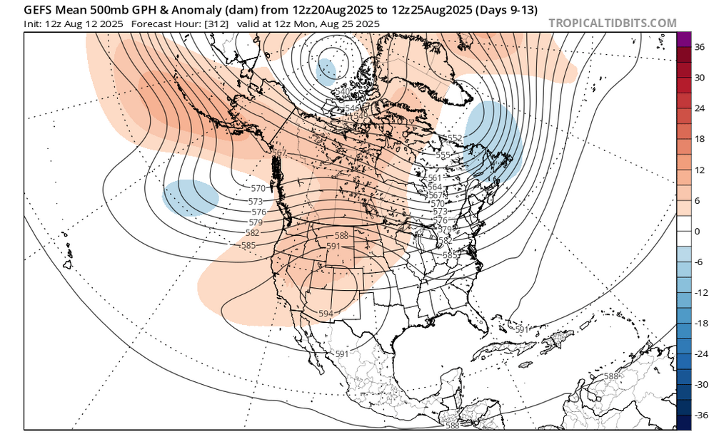
Still lookin good for some nice 'coolish' weather just beyond mid month with h5 ridge out west.
-
 Had a high temp of 93 here today. 91 yesterday and 90 on Sunday. We'll make it a 4 day heat wave tomorrow. We'll see if we can make it a 5 day heat wave on Thursday ... it's gonna be close.
 -
 While we are only 6 summers into the 2020s, it’s been significantly warmer than the Philly to Newark corridor was back in the 1990s. If we continue this level of summer warmth for the next 4 summers, then it will have the highest number of 90° days on record. The previous leader for 90° days was the 2010s. Philly to Newark corridor average annual number of 90° days by decade 2020s….Philly….35…..Hightstown….39…..Newark….36 2010s…. 34….33…32 2000s….23…..21…23 1990s…..31…..20…29 1980s…..26….21….26 1970s……22….14….20 1960s……17…..20….21 1950s…..26……23…25 1940s…..26…..23….25
 -
Beat it once already this summer, haha. But yeah, as we keep getting warmer and warmer, they keep coming further north and up in elevation.
-
Some poppage.
-
 The weird thing is I distinctly remember in 1995 when we had a ton of recurving hurricanes (they could never get past the 70W barrier) and all it did was make it hotter here. August was historically hot and dry and we had so many wildfires that month.
 -
Looks like my 2 yr old niece drew that.
-
Chris, was 1983 the only time that we had 95+ degree high temperatures in all four months (June, July, August, and September)? Maybe 2010 matched that year?
-
They're closing all the beaches at 5 because of the deaths caused by the rip currents from what I have heard.
-
what kind of wind was needed to get New Brunswick to 101 degrees but can't even hit 90 degrees here? The waters are much colder up there!
-
 82/73 at my station now after a high of 87. SE wind off the water.
 -
In the end, this summer will end up only slightly warmer than normal but it will be a fairly dry one.
-
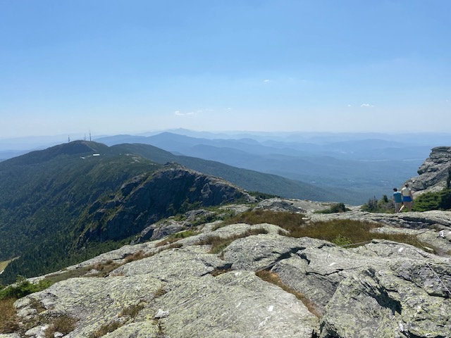
wow yall have amazing views up there in the new england area great photos of scenery
-
that stupid sea breeze (which also makes rip currents worse and caused 2 deaths)
-
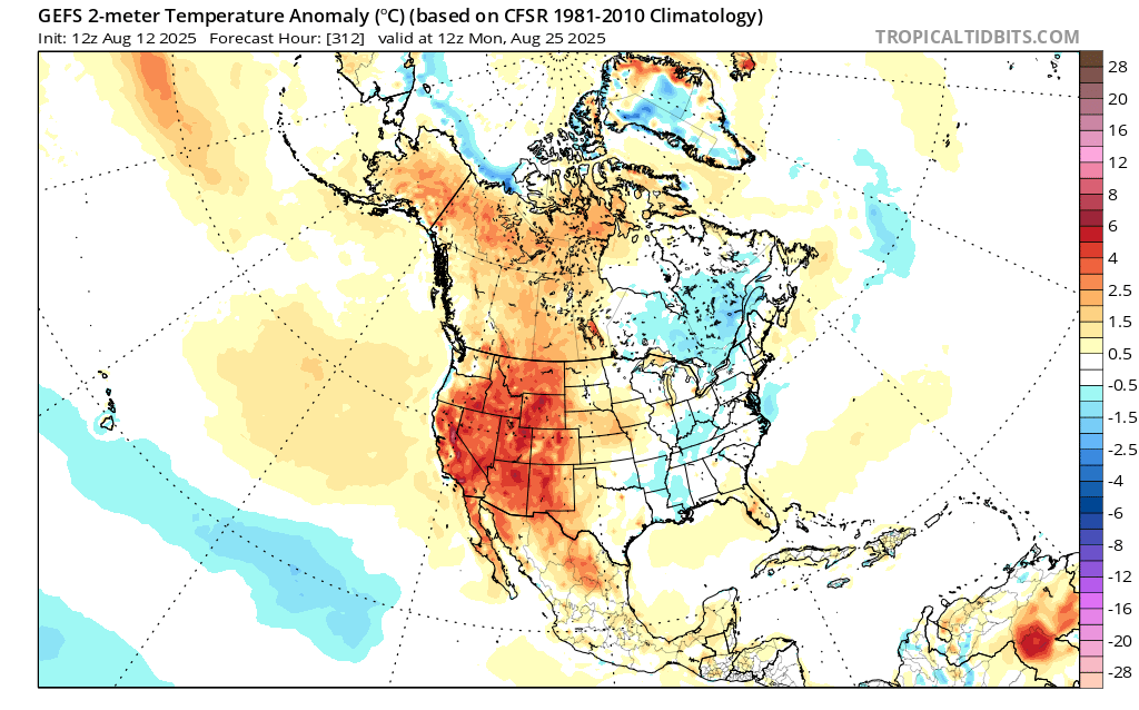
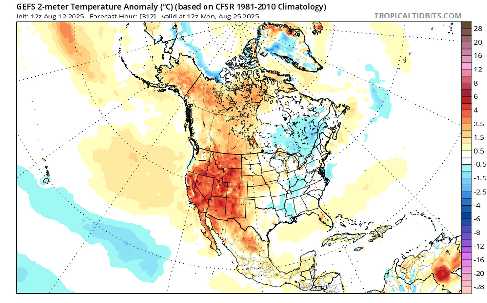
Near record and record heat again covered parts of Upstate New York, northern New England, Ontario, Quebec, New Brunswick, and Nova Scotia. Preliminary highs as of 4 pm: Bangor: 97° Boston: 91° Buffalo: 91° Burlington: 97° (new daily record) Caribou: 93° (tied daily record) Concord: 95° Gaspé, QC: 96° (new August record) Manchester: 94° Miramichi, NB: 101° (new all-time record) Montreal: 94° (new daily record) New York City-Central Park: 91° New York City-LaGuardia Airport: 91° Newark: 92° Ottawa: 95° Plattsburgh: 92° (new daily record) Portland: 90° Tomorrow and Thursday will be very warm days. Temperatures will likely reach or exceed 90° in parts of the area. Aside from some showers or thundershowers Wednesday night into Thursday morning, mainly dry conditions will likely persist through at least the next weekend. The guidance continues to step down toward a cooler period following next weekend. The weekly guidance suggests that the remainder of the months will be close to normal. As a result, of the cooling of the extended guidance, the sensitivity analysis has flipped toward a slightly cooler than normal outcome for the month overall. The ENSO Region 1+2 anomaly was +0.8°C and the Region 3.4 anomaly was -0.3°C for the week centered around August 6. For the past six weeks, the ENSO Region 1+2 anomaly has averaged +0.50°C and the ENSO Region 3.4 anomaly has averaged -0.15°C. Neutral ENSO conditions will likely continue into early autumn. The SOI was -10.80 yesterday. The preliminary Arctic Oscillation (AO) was -0.492 today. Based on sensitivity analysis applied to the latest guidance, there is an implied 53% probability that New York City will have a cooler than normal August (1991-2020 normal). August will likely finish with a mean temperature near 75.9° (0.2° below normal). Supplemental Information: The projected mean would be 0.7° above the 1981-2010 normal monthly value.
-
i just zoomed in super close on this pic and saw no fewer than eleventy billion ticks. Good luck with the Lyme