All Activity
- Past hour
-

December 14th - Snow showers or Plowable snow?
UnitedWx replied to Sey-Mour Snow's topic in New England
LOL exactly. I remember one storm in 1987 where we had 10 inches. We were in such a terrible winter stretch that it seems like 3 feet. CC aside, hopefully the pattern continues to evolve and we get better flow characteristics or just better luck as we move forward. -
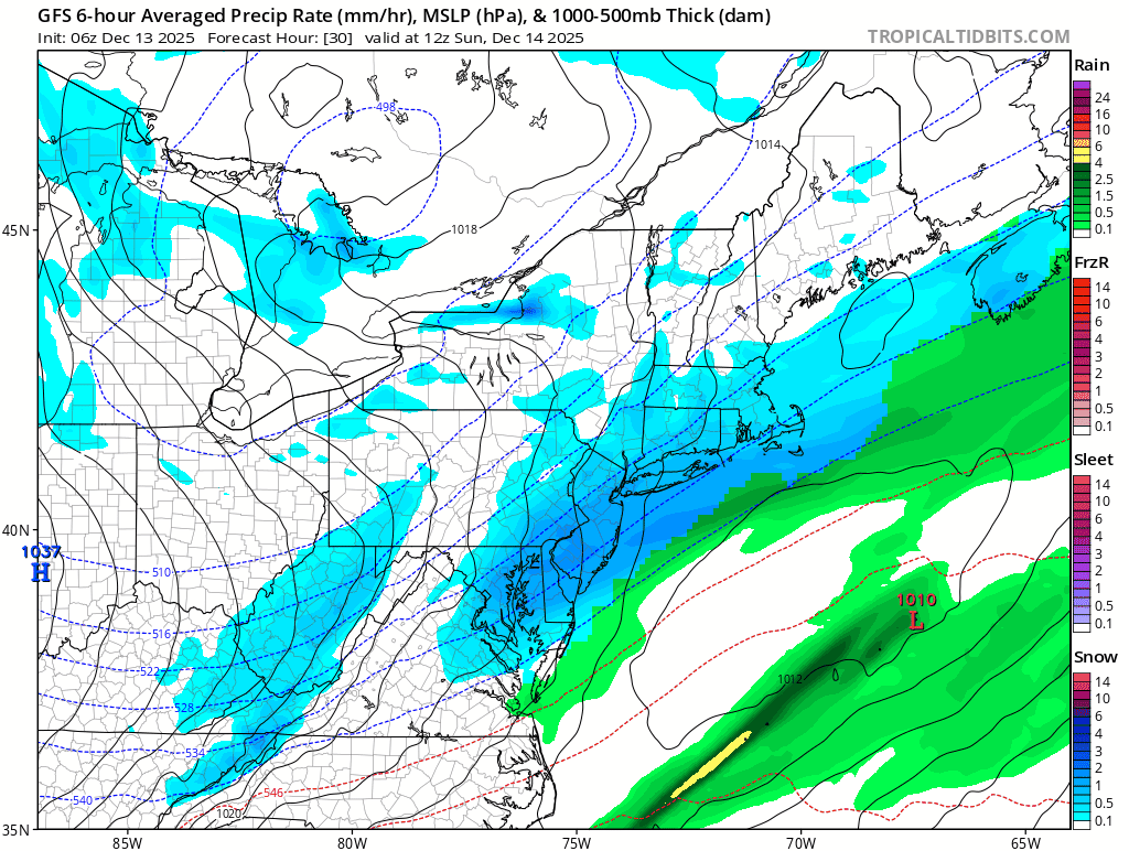
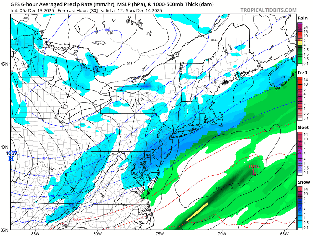
12z GFS now has a surface low off the Jersey coast, which allows precip to fill in better. Looks like 0.5" QPF line bumps back from Delaware to the Harford/Cecil County line.
-

12/14: Sunday funday? Will the south win again?
DDweatherman replied to TSSN+'s topic in Mid Atlantic
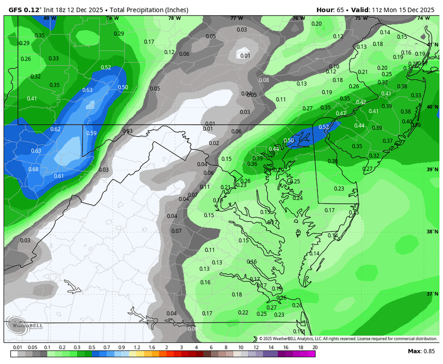
That 4 run loop of the gfs is sweet. Look at the QPF max increasing as well on the east side out towards NJ. In general, slightly slower, more amplified system and some great rates in the main bands. -
Wasn’t talking about 50 miles north haha just meant the whole thing keeps backing up to the nw each run.
-

Saturday night/Sunday 12/13-12/14 Jawn
LVblizzard replied to Ralph Wiggum's topic in Philadelphia Region
Not sure how much globals matter at this point, but the 12z GFS has finally fully caught on and has a nice solid 3-6” storm for this entire subforum. -

Moderate snowfall 12/14/2025 WWA up for most of the area
MJO812 replied to WeatherGeek2025's topic in New York City Metro
Gfs shifted the heavier precip towards the southside of NYC area -
Dude took a hit of snow weenie bump this morning.
-

Moderate snowfall 12/14/2025 WWA up for most of the area
psv88 replied to WeatherGeek2025's topic in New York City Metro
Glad you picked Commack! -
Went from flurries here to 3-5” in 24hrs on the gfs. Solid work
-

12/14: Sunday funday? Will the south win again?
NorthArlington101 replied to TSSN+'s topic in Mid Atlantic
Sorry I was trying to factor in your location. You worrying about more N usually is bad for most of us -
I definitely believe I’m hardwire for snow. My parents didn’t know what to make of it when I was a child. Then as teenager when I witnessed PD I, well, it cemented in me forever.
-

December 11th-14th Double Banger Clippers
Chambana replied to Jackstraw's topic in Lakes/Ohio Valley
Rippin fatties in the paign. Call looking $. -
TSSN’s computer screen is zoomed way in on Hanover, PA and doesn’t look anywhere else.
-
I think he's interpreting it as NW just due to the perspective from his locale, but yeah precip on the whole took a 25+ mile jump due West from 6z. Maybe a slight North lean but more West than anything. Pretty happy that I'm back in McLean for the holidays for this one
-

December 14th - Snow showers or Plowable snow?
WxWatcher007 replied to Sey-Mour Snow's topic in New England
Did look a touch better to me. Liking the trend today. -

12/14: Sunday funday? Will the south win again?
Solution Man replied to TSSN+'s topic in Mid Atlantic
We won’t see that, too far north for us as the last storm was too far south. Maybe we can get something next time -
Last four runs. Precip shield has shifted W into western NVA and N/W into the NW areas in MD.
-
5” dot over @Kay for the jackpot
-
.thumb.jpeg.f5c6ba9d911ec96b3b124f8606aee58e.jpeg)
Moderate snowfall 12/14/2025 WWA up for most of the area
TJW014 replied to WeatherGeek2025's topic in New York City Metro
According to this sub, it has sucked since the moment I joined this AmWx -
Saturday night/Sunday 12/13-12/14 Jawn
simbasad2 replied to Ralph Wiggum's topic in Philadelphia Region
Agreed. Was originally thinking that it was going to be in South Jersey but overnight guidance has lead me to believe it'll be somewhere right along I-95. -
Talking about the main slug and overall precip field. Low closer to coast too.
-
Hi! Was wondering where you went, since it seems like you, qg_omega, and co go mia every time there's a snow or cold threat. Speaking of which, hope you enjoy the snow tomorrow. Seems like you and areas to your south near NYC are game for an appreciable December snowfall.
-

December 11th-14th Double Banger Clippers
cyclone77 replied to Jackstraw's topic in Lakes/Ohio Valley
Had about a 15 min burst of heavy snow that put down a quick half inch. Back to pixies now. -
.thumb.png.4150b06c63a21f61052e47a612bf1818.png)
December 14th - Snow showers or Plowable snow?
HIPPYVALLEY replied to Sey-Mour Snow's topic in New England
Nantucket sleigh ride? -

December 14th - Snow showers or Plowable snow?
CoastalWx replied to Sey-Mour Snow's topic in New England
Subtle but did look better at 500 too. Just keep an eye on that from rt 44 south.