All Activity
- Past hour
-

January 2026 regional war/obs/disco thread
Go Kart Mozart replied to Baroclinic Zone's topic in New England
I'll be pissed if I get only 22" while the Laurel Highlands get 73".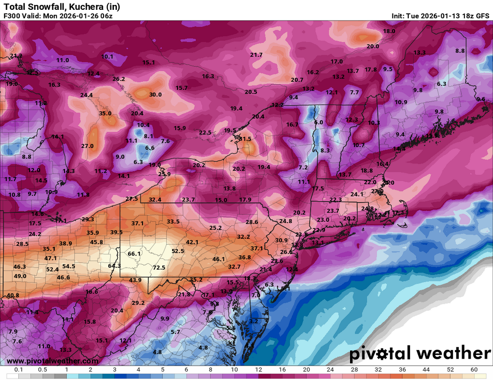
-
As much as I would like to believe this, it's been dry as f here. Every precip chance just fizzles out. I'm just thinking it will be dry
-

Central PA Winter 25/26 Discussion and Obs
AMDEW80 replied to MAG5035's topic in Upstate New York/Pennsylvania
WOW that is impressive, fingers crossed! Just don’t like the snow hole up here, I want over 4 feet as well -

January 2026 regional war/obs/disco thread
The 4 Seasons replied to Baroclinic Zone's topic in New England
Only 88" to go -


-

January 2026 regional war/obs/disco thread
weatherwiz replied to Baroclinic Zone's topic in New England
12z was active…it just wasn’t want people wanted to see lol. But the upcoming stretch should be more on the active side -

January 2026 regional war/obs/disco thread
WinterWolf replied to Baroclinic Zone's topic in New England
They want to see the Euro at 12:30 am. -
Oh those rates were unbelievable once 2 or 3am hit with these huge flakes and several inches/hour for 2+ hours. But being out in the Megalopolis storm in 2/83, pushing my uncle's car out of the snow during the hour when BWI reported 4" of snow with repetitive lightning strikes and claps of thunder was probably better!
-
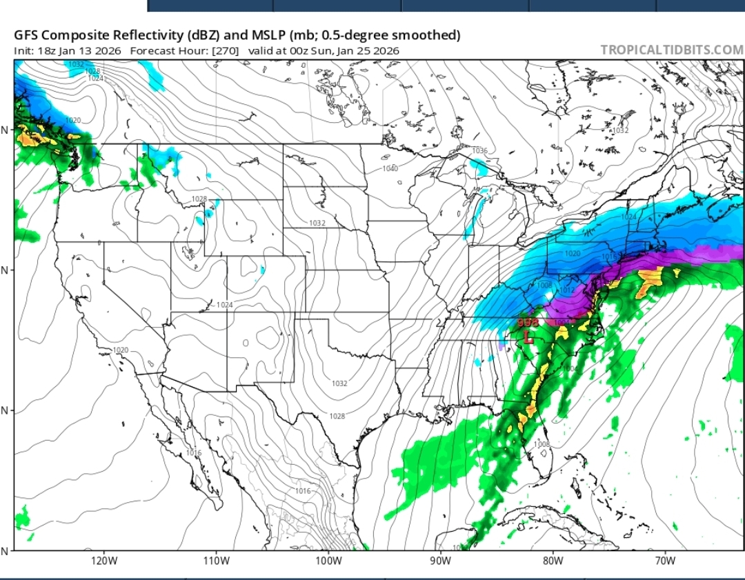
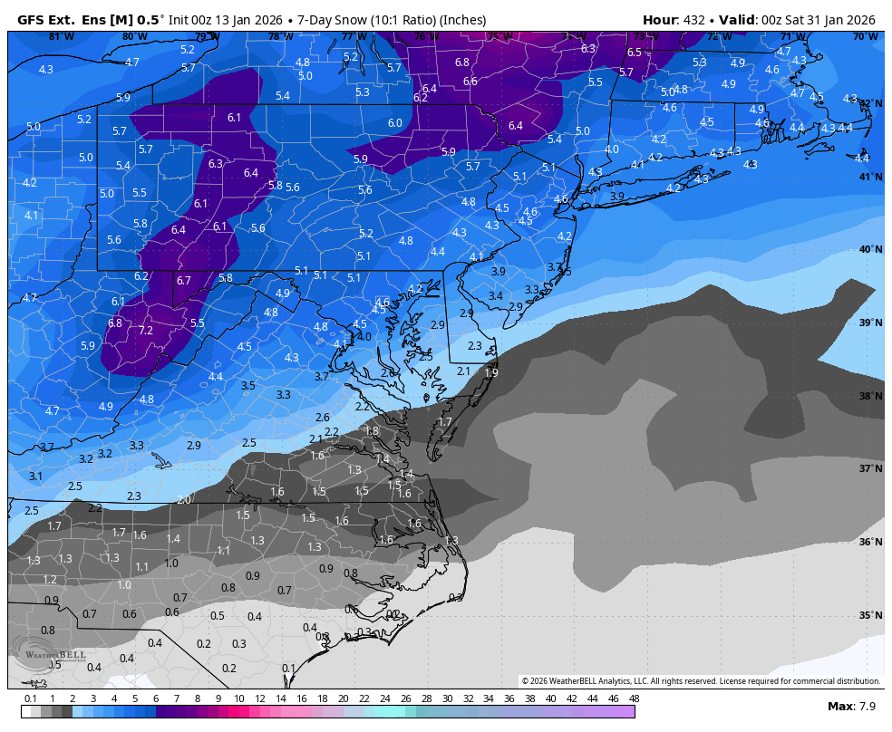
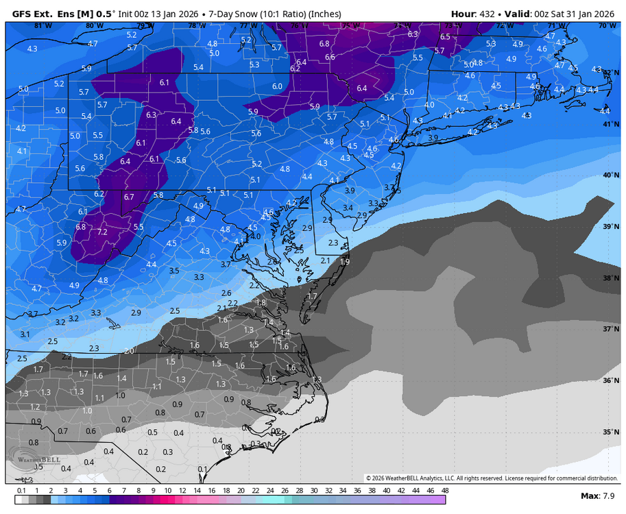
WB latest GEFS extended showing a snowy look for the last week of January.
-
January 2026 regional war/obs/disco thread
WinterWolf replied to Baroclinic Zone's topic in New England
Really? At 12z it was thought to be as dead as dead could be. 8 hrs later and it’s done a 180? -
I've been talking about cold retrogressing to the West with time in 2026. We're finally seeing it show up now. Will be curious to see how the winter finishes up nationally. We're running "only" +6F now for January, big improvement on December since we're already 150% of average for moisture this month. A lot of the NW is running +10-20 above normal winter to date. Its hard to believe some kind of nasty regression to the mean isn't coming with Western Canada still very cold. As the cold moves toward a more-centered West location and moisture picks up as the La Nina weakens/dies, we should slowly move into a regime of different storm tracks and more powerful systems. I fully expect large areas of the lower 48 to see most of their significant snows in Feb-Mar. Activity by NE Asia earlier in the month supported more western storminess very late month January.
-

Central PA Winter 25/26 Discussion and Obs
Blizzard of 93 replied to MAG5035's topic in Upstate New York/Pennsylvania
Great post & reminder of what our seasonal averages are in the LSV. MDT averages 30 inches of snow per season. The monthly breakdown if I recall correctly is 1 inch in November, 5 in December, 9 in January, 10 in February & 5 in March. Currently MDT is sitting at 5 inches for the season to date. By the end of January, MDT needs to score about 11 inches to stay on pace for the seasonal average. -

January 2026 regional war/obs/disco thread
RUNNAWAYICEBERG replied to Baroclinic Zone's topic in New England
They’re probably waiting for the 0z runs just to be sure. -
Funny you say that: the NBM’s footprint is further west tonight than some of the snowier OPs we saw at 18z. It would favor Delmarva southwest through the Virginia/NC piedmonts into western NC.
-
January 2026 regional war/obs/disco thread
weatherwiz replied to Baroclinic Zone's topic in New England
Active times coming up. Details TBD -
It's insane how hostile this region is to snow.
-
.thumb.png.4150b06c63a21f61052e47a612bf1818.png)
January 2026 regional war/obs/disco thread
HIPPYVALLEY replied to Baroclinic Zone's topic in New England
Maybe NWS needs a new category? They could start issuing WSSP‘s. “winter storm speculation” maybe use a weenie color shading on the map, -
AFC championship game. Allen vs Maye for all the marbles.
-
January 2026 regional war/obs/disco thread
The 4 Seasons replied to Baroclinic Zone's topic in New England
Tales from...you know things are bad when... If there was an imminent large storm to track or we were on the eve of one, no one would even mention it. But it's all we got, OP fantasy colors. Def keep an eye on this one, though it's got a shot. 18 GEFS still has a good handful of hits or just near misses- depending on where you live.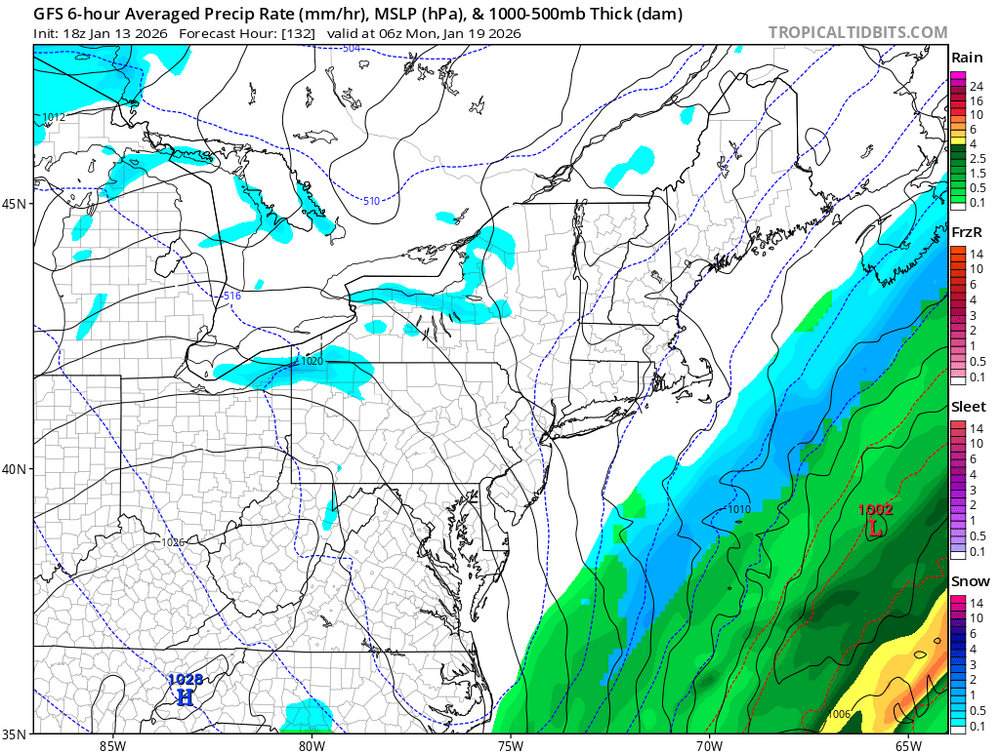
-
This is fantastic, lolol
-
Central PA Winter 25/26 Discussion and Obs
Blizzard of 93 replied to MAG5035's topic in Upstate New York/Pennsylvania
I just recently set up a few folks on the “Ignore” feature on here for the first time in my 12 years of membership. My viewing experience on here is already so much better. If no one replies, I’ll never see certain posts. I highly recommend it! -
Yeah obviously. I mean maybe for the season in the lake effect area sure. But central Ohio? No way.
-

January 2026 regional war/obs/disco thread
ORH_wxman replied to Baroclinic Zone's topic in New England
Yeah I was hoping winter storm watches would be posted tonight. -
-
Central PA Winter 25/26 Discussion and Obs
Blizzard of 93 replied to MAG5035's topic in Upstate New York/Pennsylvania
I’ve looked at a lot of snow maps in my lifetime, but I’m not sure if I’ve ever seen a 16 day map for Central PA that produced these insane amounts. I think most would be thrilled if we approached near 1 foot in the next 16 days…