All Activity
- Past hour
-
Pouring now.. im guessing BOX will issue flood watches at some point for tomorrow and tomorrow night.. this much added rain wasn't forecasted
-
There are several spots that look like could be mesolows on radar… just east of Sterling too now. Like curling echoes like they are wrapping around something.
- Yesterday
-

2025 Lawns & Gardens Thread. Making Lawns Great Again
Damage In Tolland replied to Damage In Tolland's topic in New England
I live in the woods … especially the backyard . That’s kind of the side/back yard. When I post about my hatred of Oaks.. that should give a good visual why . I would not be unhappy at all if a huge blowdown of all of those happened . It’s a slope, below a larger slope on the other side of the big flowerbed to the right partially pictured there.. so it’s always a losing battle that I try to fight and maintain -

Central PA Spring 2025
Mount Joy Snowman replied to canderson's topic in Upstate New York/Pennsylvania
Not particularly, only isolated chances. The real show arrives overnight. With that said, I’m caught in a nice narrow band over here that’s dropping a steady rain and barely moving, a pretty unique radar presentation. -
Looks like the whole thing is spinning.. low forming just east of Belchertown?
-
 Lelorum joined the community
 -

2025 Lawns & Gardens Thread. Making Lawns Great Again
backedgeapproaching replied to Damage In Tolland's topic in New England
That's insane coverage for what looks like pretty dense shade come full leaf out. Definitely looks good, but like you said will be interested to see it towards Aug/Sept. -
Little s/w or something because there’s a good cell over the water popping east of me.
-
yup, @ .91" now
-
that's hilarious
-
Everyone should try to stay as safe as they possibly can
-
Just saw flood warning on tv but its NW of me in western Worc County
-
 Table of Forecasts for May 2025 FORECASTER _____________________ DCA _NYC _BOS __ORD _ATL _IAH __DEN _PHX _SEA wxallannj__________________________+2.5 _+2.5 _+2.5 __ +3.5 _+1.3 _+1.2 __+1.0 _+0.5 _+0.3 BKViking ___________(-2%)_________+2.3 _+2.3 _+2.1 __ +1.4 _+1.0 _+1.0 __+2.0 _+1.3 _+1.3 RJay ________________(-2%)________ +2.0 _+2.5 _+2.5 __+2.0 _+1.0 _+1.0 __+1.5 __ 0.0 _+1.5 wxdude64 ________________________ +1.8 _+1.9 _+1.7 __ +2.1 _+1.4 _ +1.1 __ +1.5 _+0.5 _+0.4 DonSutherland1 ___________________ +1.7 _+1.7 _+1.7 __+1.3 _+0.8 _+0.9 __+0.2 _-0.8 _+0.2 Scotty Lightning __________________ +1.5 _+1.0 _+1.0 __ +1.0 _+2.0 _+2.0 __+1.0 _+1.5 _+0.5 ___ Consensus ___________________+1.5 _+1.6_+1.7 __+1.4 _+1.0 _+1.0 __+1.3 _+0.5 _+0.5 StormchaserChuck _______________ +1.4 _+1.6 _+1.8 __ +2.9 _+0.4 _-0.6 __+1.1 _ +0.1 _+1.0 so_whats_happening ______________+1.4 _ +1.6 _ +1.7 __+1.9 _+0.5 _-0.2 __+1.5 _+0.3 _+0.5 Roger Smith _______________________ +1.3 _+1.4 _+1.5 __+1.2 _+0.7 _+0.5 __+2.7 _+1.0 _+1.5 RodneyS __________________________ +1.0 _+1.0 _+0.4 __ -1.8 _ +0.2 _+0.7 __+1.0 _-0.2 _-0.6 hudsonvalley21 ____________________+0.8 _+0.6 _+0.3 __ +1.4 _+1.7 _+1.2 __+1.8 _+2.1 _-0.2 Tom _______________________________ +0.6 _+0.8 _+0.8 __+1.1 _+0.4 _+0.9 __+0.8 _+0.5 _+0.7 ___ Normal _________________________ 0.0 __ 0.0 __0.0 ___ 0.0 __0.0 __0.0 ___ 0.0 __ 0.0 _ 0.0 ______ Persistence (Apr 2025) _____________+3.5 _+1.6 _+2.2 __+1.1 _+4.5 _+4.6 __+1.7 _+1.4 _+0.8 ================== Normal is lower than all forecasts at DCA, NYC, BOS, ATL, DEN
 -
Another system will affect the region tomorrow into Saturday before drier air returns. Showers and perhaps some heavy thunderstorms are possible. A general 0.50"-1.50" rainfall is likely with some locally higher amounts. Some of those areas with locally higher amounts could pick up in excess of 3" of rain. Following the weekend, it will turn warmer and possibly drier. Some showers will be possible Tuesday night into Wednesday. The ENSO Region 1+2 anomaly was +0.1°C and the Region 3.4 anomaly was -0.1°C for the week centered around April 30. For the past six weeks, the ENSO Region 1+2 anomaly has averaged +0.68°C and the ENSO Region 3.4 anomaly has averaged -0.05°C. Neutral ENSO conditions will likely continue through at least early summer. Early indications are that summer 2025 will be warmer than normal in the New York City and Philadelphia areas. The potential exists for a much warmer than normal summer (more than 1° above normal). The SOI was +0.48 today. The preliminary Arctic Oscillation (AO) was +1.339 today. Based on sensitivity analysis applied to the latest guidance, there is an implied near 79% probability that New York City will have a warmer than normal May (1991-2020 normal). May will likely finish with a mean temperature near 66.2° (3.0° above normal). That would make 2025 the 9th warmest May on record.
-
Dumping and not even under heaviest echos.
-
Paxton, Holden, Lancaster getting smoked
-
Nice 7th grader graffiti in the upper center of that. Lol
-
Sterling smoked
-

E PA/NJ/DE Spring 2025 Obs/Discussion
Birds~69 replied to PhiEaglesfan712's topic in Philadelphia Region
Stuff out by Reading and I can see the dark clouds to my West, winds picked up as well. I'm hoping for the worst... 66F,/gusty -
.63 here in 20 minutes
-
Just drove around the block and went from nothing at my house to flooding rains in a instant.. had to do it twice that was awesome.. almost stationary storm ftw
-
Yeah thunder all around, storm seemed to be a bit SW of us though. Leominster flooded again? Edit: saw coastal already posted that lol
-
Unreal, .71" just dumping, 58F
-
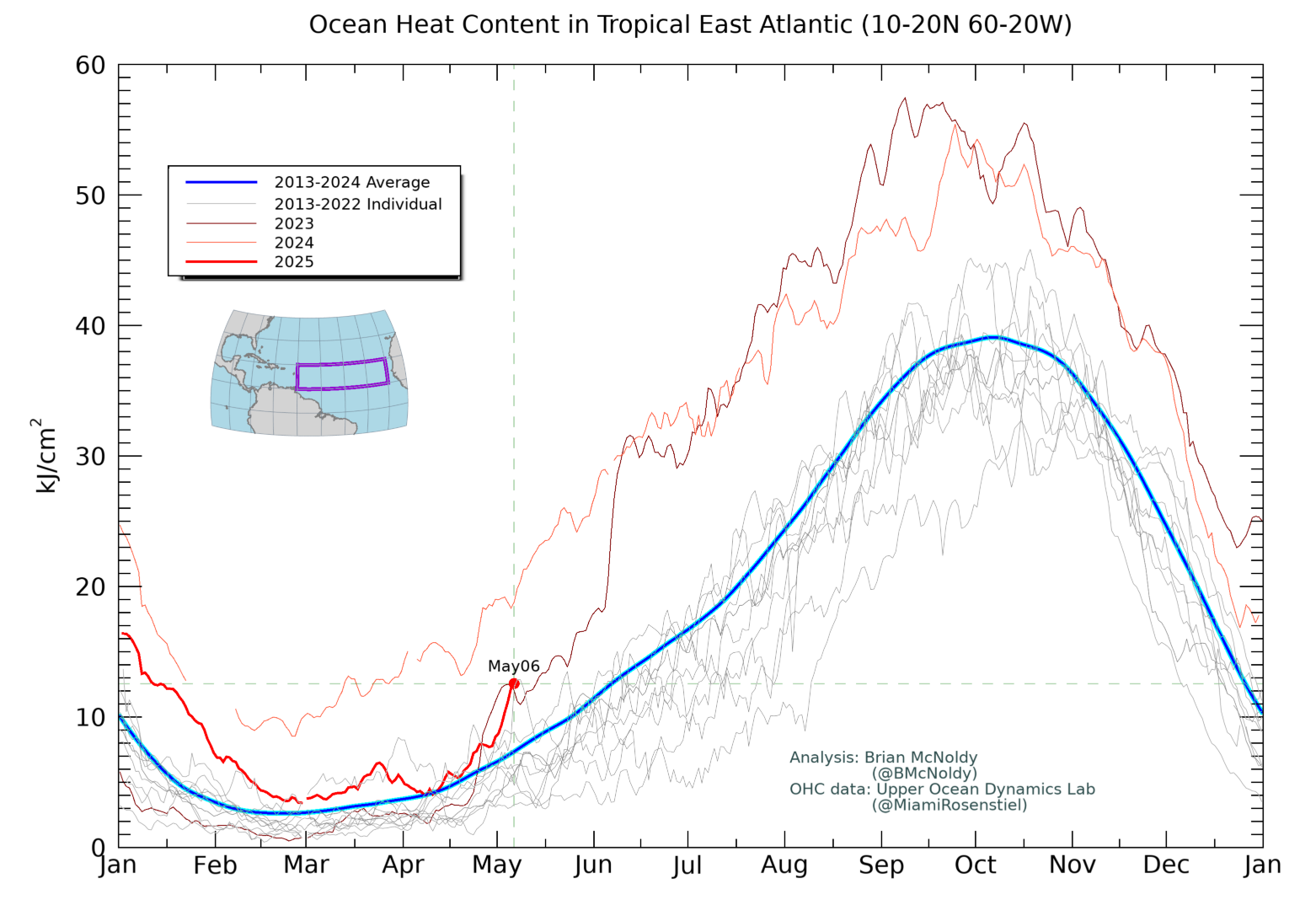
The east tropical Atlantic (20-60W) has warmed rapidly over the last week:
-
Steady rain now.
-
Hopefully some decent flooding!