All Activity
- Past hour
-

2026 Mid-Atlantic Severe Storm General Discussion
AlexD1990 replied to Kmlwx's topic in Mid Atlantic
Confirmed large and dangerous tornado -
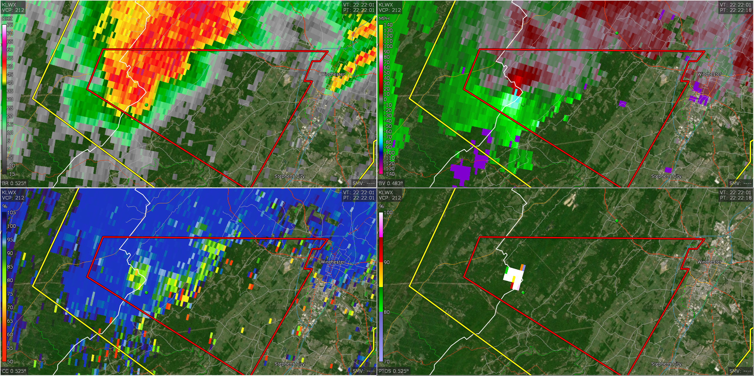
Now a PDS warning Severe Weather Statement National Weather Service Baltimore MD/Washington DC 629 PM EDT Tue Jul 21 2026 VAC069-212245- /O.CON.KLWX.TO.W.0017.000000T0000Z-260721T2245Z/ Frederick VA- 629 PM EDT Tue Jul 21 2026 ...A TORNADO WARNING REMAINS IN EFFECT UNTIL 645 PM EDT FOR SOUTH CENTRAL FREDERICK COUNTY IN NORTHWESTERN VIRGINIA... At 629 PM EDT, a confirmed large and extremely dangerous tornado was located near Star Tannery, or 10 miles west of Winchester, moving east at 20 mph. This is a PARTICULARLY DANGEROUS SITUATION. TAKE COVER NOW! HAZARD...Damaging tornado. SOURCE...Radar confirmed tornado. IMPACT...You are in a life-threatening situation. Flying debris may be deadly to those caught without shelter. Mobile homes will be destroyed. Considerable damage to homes, businesses, and vehicles is likely and complete destruction is possible. Locations impacted include... High View Manor and Wilde Acres. PRECAUTIONARY/PREPAREDNESS ACTIONS... To repeat, a tornado is on the ground. To protect your life, TAKE COVER NOW! Move to a basement or an interior room on the lowest floor of a sturdy building. Avoid windows. If you are outdoors, in a mobile home, or in a vehicle, move to the closest substantial shelter and protect yourself from flying debris. && LAT...LON 3918 7819 3907 7827 3915 7841 3918 7839 TIME...MOT...LOC 2229Z 291DEG 18KT 3915 7837 TORNADO...OBSERVED TORNADO DAMAGE THREAT...CONSIDERABLE MAX HAIL SIZE...<.75 IN $$ DHOF
-

2026 Mid-Atlantic Severe Storm General Discussion
NorthArlington101 replied to Kmlwx's topic in Mid Atlantic
PDS -

2026 Mid-Atlantic Severe Storm General Discussion
SnowenOutThere replied to Kmlwx's topic in Mid Atlantic
Tornado emergency warning issued -

2026 Mid-Atlantic Severe Storm General Discussion
wxmeddler replied to Kmlwx's topic in Mid Atlantic
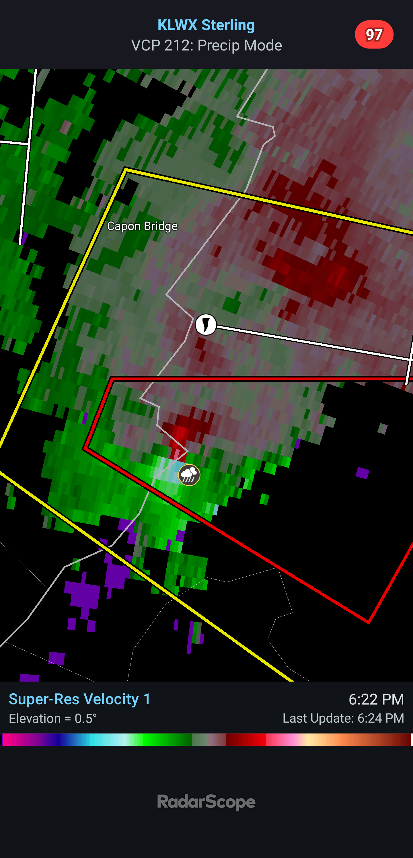
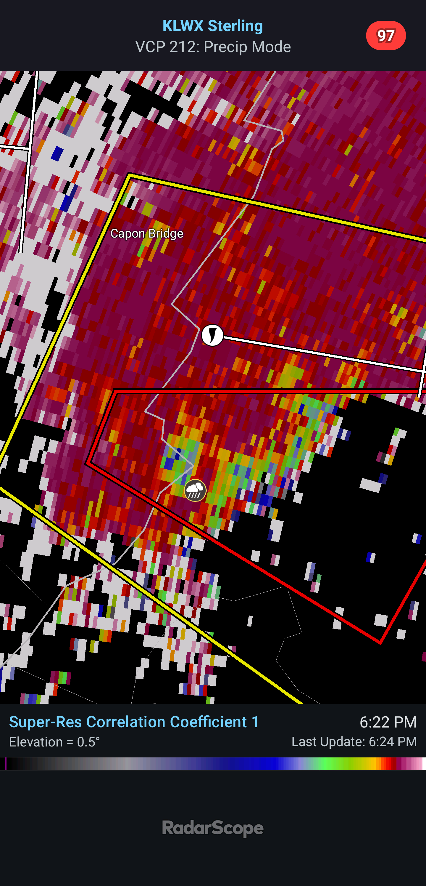
Very obvious TDS west of Winchester. LWX has gone radar confirmed.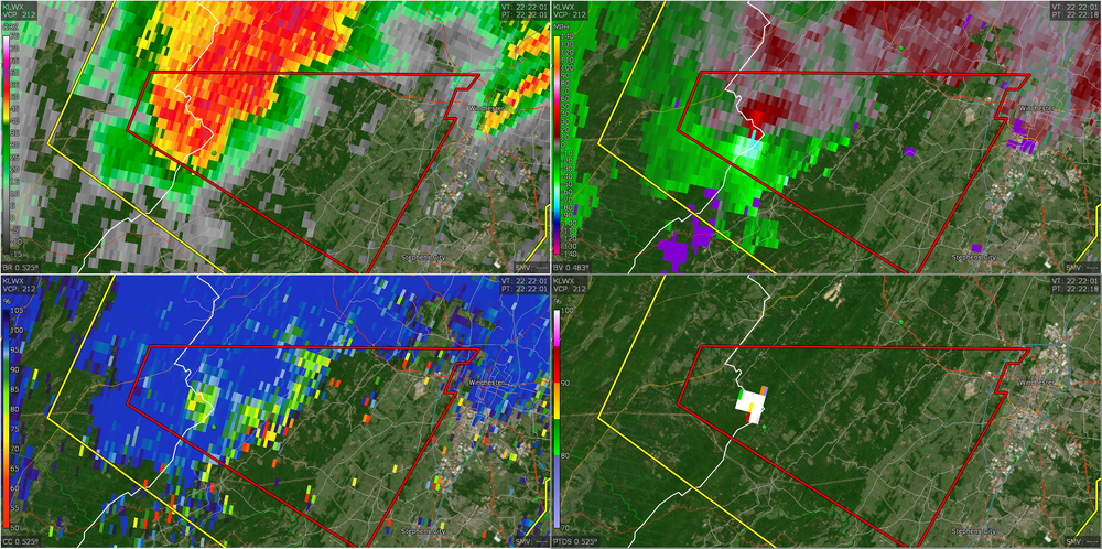
-
Um uh oh Severe Weather Statement National Weather Service Baltimore MD/Washington DC 629 PM EDT Tue Jul 21 2026 VAC069-212245- /O.CON.KLWX.TO.W.0017.000000T0000Z-260721T2245Z/ Frederick VA- 629 PM EDT Tue Jul 21 2026 ...A TORNADO WARNING REMAINS IN EFFECT UNTIL 645 PM EDT FOR SOUTH CENTRAL FREDERICK COUNTY IN NORTHWESTERN VIRGINIA... At 629 PM EDT, a confirmed large and extremely dangerous tornado was located near Star Tannery, or 10 miles west of Winchester, moving east at 20 mph. This is a PARTICULARLY DANGEROUS SITUATION. TAKE COVER NOW! HAZARD...Damaging tornado. SOURCE...Radar confirmed tornado. IMPACT...You are in a life-threatening situation. Flying debris may be deadly to those caught without shelter. Mobile homes will be destroyed. Considerable damage to homes, businesses, and vehicles is likely and complete destruction is possible. Locations impacted include... High View Manor and Wilde Acres. PRECAUTIONARY/PREPAREDNESS ACTIONS... To repeat, a tornado is on the ground. To protect your life, TAKE COVER NOW! Move to a basement or an interior room on the lowest floor of a sturdy building. Avoid windows. If you are outdoors, in a mobile home, or in a vehicle, move to the closest substantial shelter and protect yourself from flying debris. && LAT...LON 3918 7819 3907 7827 3915 7841 3918 7839 TIME...MOT...LOC 2229Z 291DEG 18KT 3915 7837 TORNADO...OBSERVED TORNADO DAMAGE THREAT...CONSIDERABLE MAX HAIL SIZE...<.75 IN
-

2026 Mid-Atlantic Severe Storm General Discussion
canderson replied to Kmlwx's topic in Mid Atlantic
29 right past E City is partially underwater. Ask me how I know. -
I have a gut feeling these storms will be worse than they are thought to be tonight. .
-
2026 Mid-Atlantic Severe Storm General Discussion
AlexD1990 replied to Kmlwx's topic in Mid Atlantic
Over 100kts gtg -

2026 Mid-Atlantic Severe Storm General Discussion
weatherCCB replied to Kmlwx's topic in Mid Atlantic
0.25” with a 10 min storm -
2026 Mid-Atlantic Severe Storm General Discussion
AlexD1990 replied to Kmlwx's topic in Mid Atlantic
Moved out and got a few breaks of sun...but looks like we might be victims of subsidence -
2026 Mid-Atlantic Severe Storm General Discussion
NorthArlington101 replied to Kmlwx's topic in Mid Atlantic
It’s OTG - spotted.- 1,393 replies
-
- 1
-

-
- severe
- thunderstorms
- (and 7 more)
-
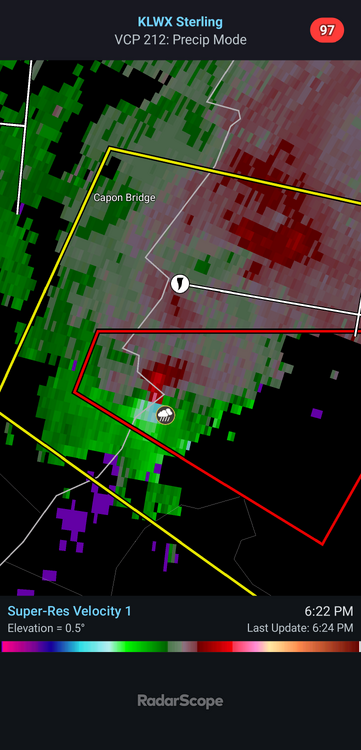
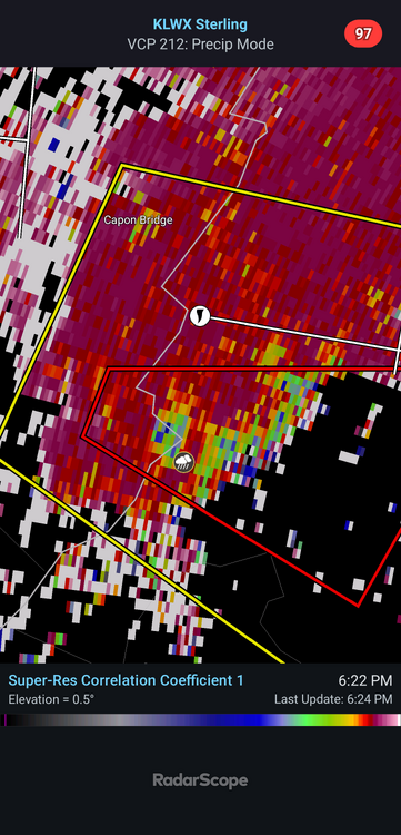
Getting hooky near Purcellville...
-
Severe Weather Statement National Weather Service Baltimore MD/Washington DC 624 PM EDT Tue Jul 21 2026 VAC069-WVC027-212245- /O.CON.KLWX.TO.W.0017.000000T0000Z-260721T2245Z/ Frederick VA-Hampshire WV- 624 PM EDT Tue Jul 21 2026 ...A TORNADO WARNING REMAINS IN EFFECT UNTIL 645 PM EDT FOR SOUTHWESTERN FREDERICK COUNTY IN NORTHWESTERN VIRGINIA AND SOUTHEASTERN HAMPSHIRE COUNTIES IN EASTERN WEST VIRGINIA... At 624 PM EDT, a confirmed tornado was located near Star Tannery, or 11 miles north of Strasburg, moving east at 20 mph. HAZARD...Damaging tornado. SOURCE...Radar confirmed tornado. IMPACT...For those in the direct path of a tornado touchdown, flying debris will be dangerous to those caught without shelter. Damage to roofs, siding, and windows may occur. Mobile homes may be damaged or destroyed. Tree damage is likely. Locations impacted include... Winchester, High View Manor, and Wilde Acres. PRECAUTIONARY/PREPAREDNESS ACTIONS... To repeat, a tornado is on the ground. TAKE COVER NOW! Move to a basement or an interior room on the lowest floor of a sturdy building. Avoid windows. If you are outdoors, in a mobile home, or in a vehicle, move to the closest substantial shelter and protect yourself from flying debris. && LAT...LON 3921 7817 3920 7818 3920 7819 3918 7820 3918 7819 3907 7827 3916 7845 3919 7841 TIME...MOT...LOC 2224Z 290DEG 18KT 3916 7840 TORNADO...OBSERVED MAX HAIL SIZE...<.75 IN $$ DHOF
-
Wow
- 1,393 replies
-
- 2
-
-

-
- severe
- thunderstorms
- (and 7 more)
-
BULLETIN - IMMEDIATE BROADCAST REQUESTED Severe Thunderstorm Warning National Weather Service Baltimore MD/Washington DC 622 PM EDT Tue Jul 21 2026 The National Weather Service in Sterling Virginia has issued a * Severe Thunderstorm Warning for... West central Montgomery County in central Maryland... Northeastern Loudoun County in northern Virginia... * Until 700 PM EDT. * At 622 PM EDT, a severe thunderstorm was located near Purcellville, or near Leesburg, moving east at 15 mph. HAZARD...60 mph wind gusts and quarter size hail. SOURCE...Radar indicated. IMPACT...Damaging winds will cause some trees and large branches to fall. This could injure those outdoors, as well as damage homes and vehicles. Roadways may become blocked by downed trees. Localized power outages are possible. Unsecured light objects may become projectiles. * Locations impacted include... Leesburg, Lansdowne, Poolesville, Countryside, Purcellville, Belmont, Hamilton, Barnesville, Paeonian Springs, Waterford, Lucketts, Dickerson, and Beallsville. PRECAUTIONARY/PREPAREDNESS ACTIONS... Remain alert for a possible tornado! Tornadoes can develop quickly from severe thunderstorms. If you spot a tornado go at once into the basement or small central room in a sturdy structure. For your protection move to an interior room on the lowest floor of a building. && LAT...LON 3924 7737 3905 7741 3914 7771 3922 7768 3923 7747 3922 7746 3924 7742 TIME...MOT...LOC 2222Z 276DEG 15KT 3916 7765 TORNADO...POSSIBLE HAIL THREAT...RADAR INDICATED MAX HAIL SIZE...1.00 IN WIND THREAT...RADAR INDICATED MAX WIND GUST...60 MPH
-
I'll take that lol. Watching places just to the north get 1-2" while I have less than a tenth kinda sucks.
-
Got basically nothing here in New Providence, but I'll take that over tornadoes like 15 miles to my north.
-
Just got home after visiting away and it's dusty and dry so I watered my plants. P&C forecast thru tomorrow night has 0.5 to 0.75; 0.1 to 0.25; 0.1 to 0.25. My formula is take the minimum and divide in half so 0.35 total expected. Won't be surprised at a shutout though.
-
2026 Mid-Atlantic Severe Storm General Discussion
SnowenOutThere replied to Kmlwx's topic in Mid Atlantic
TDS on radar -
Tornado Warning National Weather Service Baltimore MD/Washington DC 619 PM EDT Tue Jul 21 2026 The National Weather Service in Sterling Virginia has issued a * Tornado Warning for... Southwestern Frederick County in northwestern Virginia... Southeastern Hampshire County in eastern West Virginia... * Until 645 PM EDT. * At 619 PM EDT, a severe thunderstorm capable of producing a tornado was located near Star Tannery, or 13 miles north of Strasburg, moving east at 20 mph. HAZARD...Tornado. SOURCE...Radar indicated rotation. IMPACT...For those in the direct path of a tornado touchdown, flying debris will be dangerous to those caught without shelter. Damage to roofs, siding, and windows may occur. Mobile homes may be damaged or destroyed. Tree damage is likely. * This tornadic thunderstorm will remain over mainly rural areas of southwestern Frederick County in northwestern Virginia and southeastern Hampshire Counties in eastern West Virginia, including the following locations... High View Manor, Wilde Acres, and Lehew.
-
last couple weeks have been just what we needed re: drought
-
0.84” now
-
Tornado warning in the Winchester area
-
.05 here so far