All Activity
- Past hour
-
MET from Central IL posted this. Would think this would extend north and east too? https://www.facebook.com/share/17Ay3SJdeN/
-

3/16/26 Severe Weather Event Thread (Day 2 MOD Risk)
NorthArlington101 replied to Kmlwx's topic in Mid Atlantic
Tomorrow is an obvious evening activities canceled for local school systems. Trickier call to early release depending on when the squall line is. I’d guess most schools pull the trigger. -
chicago updated We have opted to upgrade the Winter Storm Watch across our northwest to a Winter Storm Warning from 7 pm this evening through 1 pm Monday. We strongly considered a Blizzard Warning, but have opted to hold off on that at this time, though cannot rule out the need to upgrade as the event unfolds this evening. Either way the combination of falling and accumulating snow with widespread blowing snow and gusty northwest winds (up to 50 mph) will make for near blizzard conditions at times tonight into Monday morning across northwestern IL. Total snowfall amounts in the warned area are expected to be in the 3 to 6 inch range. In addition to the warning, we have also opted to issue a Winter Weather Advisory from 10 pm tonight through 1 pm Monday for areas east-southeast of the Winter Storm Warning. This basically includes areas nearly as far southeast as the I-55 corridor. Snowfall amounts in this region are expected to be lighter, generally in the 1 to 3 inch range. However, the combination of the snow and blowing snow will also make for hazardous conditions outside of the Warning area Monday morning.
-
I would guess LWX will issue a special weather statement later highlighting the risk. They put one out for the line that blew down all the power lines in Westminster in that moderate risk event like 3 years ago.
-
7pm
-

Central PA Spring 2026 Discussion/Obs Thread
anotherman replied to Voyager's topic in Upstate New York/Pennsylvania
I am as well. -
(002).thumb.png.6e3d9d46bca5fe41aab7a74871dd8af8.png)
Central PA Spring 2026 Discussion/Obs Thread
ChescoWx replied to Voyager's topic in Upstate New York/Pennsylvania
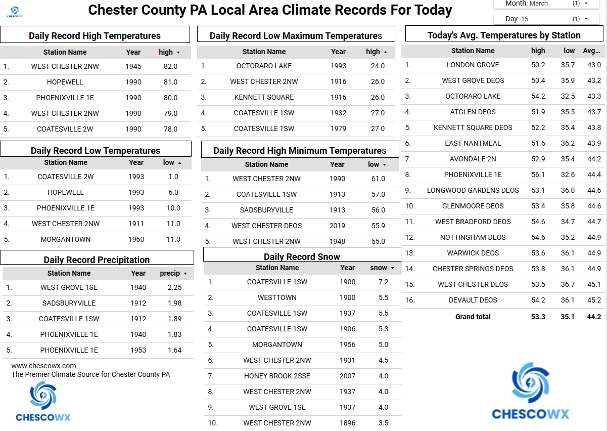
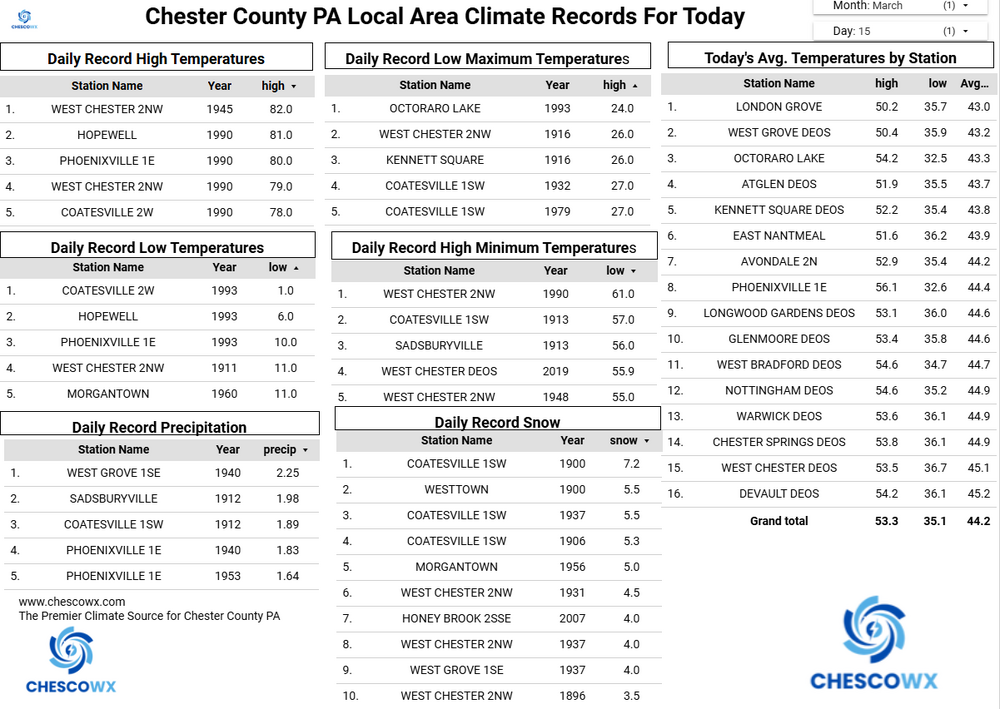
Today should be the calm before the storm. We see temperatures close to normal today in the lower 50's before rain arrives this evening. We have a chance to actually move to above normal precipitation for the year with between 1" to 1.75" of rain possible across the area. There will be a severe weather threat tomorrow especially with a strong cold frontal passage tomorrow evening. We could see temperatures fall by over 25 degrees over just a couple hours after highs well into 60's. Rain will possibly mix with or change to some brief snow before ending by Tuesday morning. We will see well below normal temperatures both Tuesday and Wednesday before we return to slightly below normal temperatures for the rest of the work week.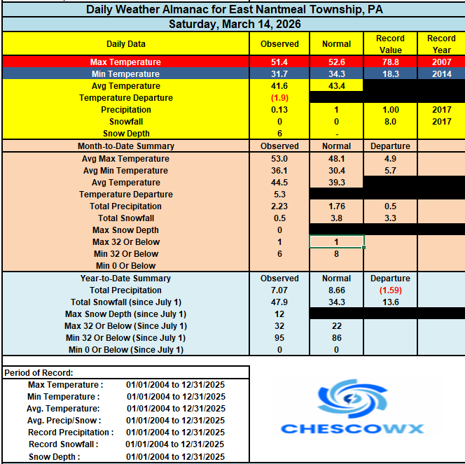
-
E PA/NJ/DE Spring 2026 Obs/Discussion
ChescoWx replied to PhiEaglesfan712's topic in Philadelphia Region
Today should be the calm before the storm. We see temperatures close to normal today in the lower 50's before rain arrives this evening. We have a chance to actually move to above normal precipitation for the year with between 1" to 1.75" of rain possible across the area. There will be a severe weather threat tomorrow especially with a strong cold frontal passage tomorrow evening. We could see temperatures fall by over 25 degrees over just a couple hours after highs well into 60's. Rain will possibly mix with or change to some brief snow before ending by Tuesday morning. We will see well below normal temperatures both Tuesday and Wednesday before we return to slightly below normal temperatures for the rest of the work week.
-
Those forecasts in the Midwest I feel often over do it on a area wide scale. But there will be a narrow band were it's potentially life threatening. A lot of areas will qualify blizzard conditions with much less snow than forecast because of severe winds.
-
H to 3rd did increase some
-
The maps that are vendor generated
.png.98b9d890a81d86ed924b76b644128251.png)
.png.290a82eef87be9a50cbb6630d4ac1c78.png)
-
39/16

-
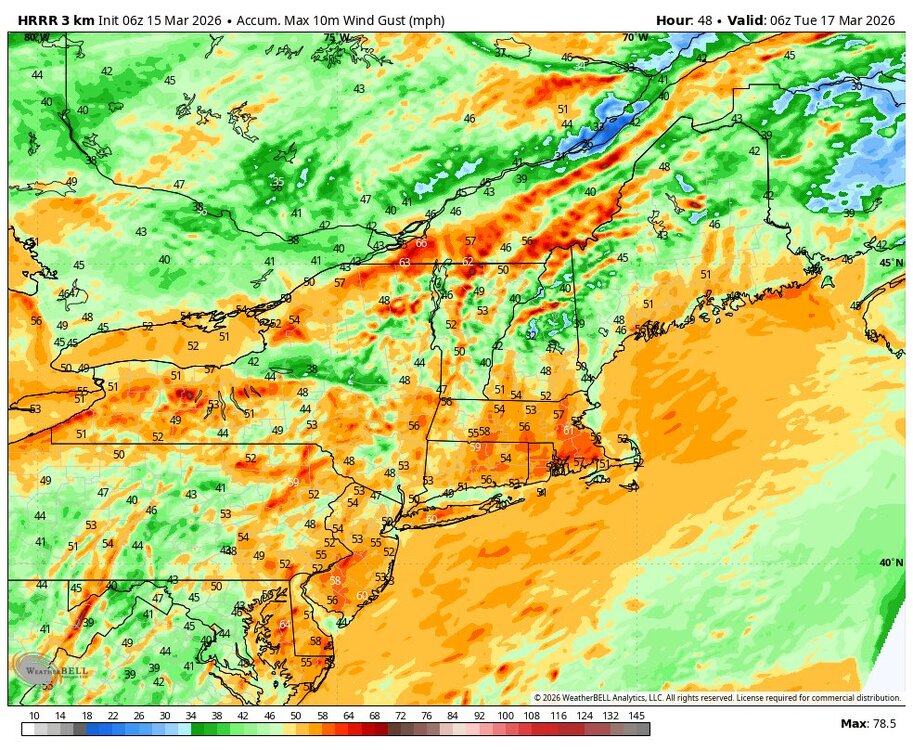
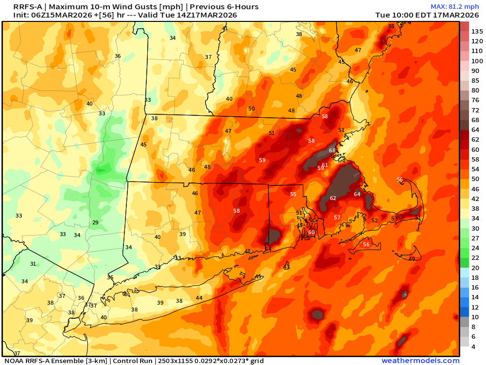
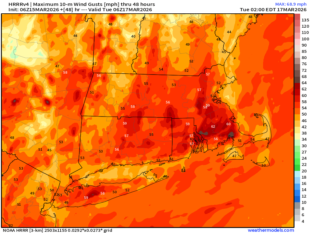
H to 3rd not that far off from NAM but still a big difference in 50-55mph vs 60-70mph in terms of damage potential
-
3/16/26 Severe Weather Event Thread (Day 2 MOD Risk)
Imgoinhungry replied to Kmlwx's topic in Mid Atlantic
What time is this map for? I am concerned about the evening commute and school buses being on the roads! . -
Probably can't rule out some strong thunderstorms during the early afternoon along the edge of higher theta-e air working in
-

Central PA Spring 2026 Discussion/Obs Thread
Itstrainingtime replied to Voyager's topic in Upstate New York/Pennsylvania
I'll go against you on this one. There is nothing exciting about tomorrow to me. I'm very concerned -
Ginxy doesn't make maps.
-

3/16/26 Severe Weather Event Thread (Day 2 MOD Risk)
weatherwiz replied to Kmlwx's topic in Mid Atlantic
Probably one of the most impressive line-embedded tornado potential I think I've seen for these parts tomorrow. Unusually when you're seeing 15% tornado probs, you are either talking about or looking for discrete cells (which of course are very possible tomorrow) but that degree of turning combined with sufficient CAPE in the layer and timing of the forcing...going to see some significant rotation embedded within that line tomorrow. -

2026-2027 El Nino
so_whats_happening replied to Stormchaserchuck1's topic in Weather Forecasting and Discussion
If this were to actually hold we would see quite the KW form and would significantly raise the chances of at least a moderate to strong Nino.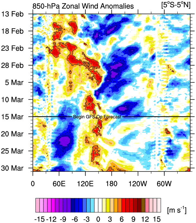
-
Tomorrow is one of the most impressive setups I think I've seen for line-embedded tornadoes in the mid-Atlantic tomorrow. That is some serious turning in the lowest 3km with what looks to be more than sufficient CAPE, not to mention the timing of the strongest forcing seems to coincide quite well with the best ingredients.
-

Central PA Spring 2026 Discussion/Obs Thread
Mount Joy Snowman replied to Voyager's topic in Upstate New York/Pennsylvania
Low of 36. All eyes on tomorrow for what should be an exciting, but hopefully not too destructive, weather day. -
That was a great winter for sure. It feels like a flip has switched during the subsequent three winters but that may or may end up proving true. However, the extent to which warm and snowless records have not just been broken but in many cases obliterated this year is ultimately more noteworthy, I believe, than a very good but not record smashing season four years ago now. That’s my take anyway.
-
8 foot wingspan?!?
-
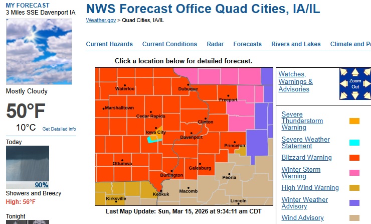
The infamous severe thunderstorm warning box within a blizzard warning.
-
Agree how many times have we been forecasted to get 1-3 from a deformation band and end up with 30 minutes of flurries