All Activity
- Past hour
-

The return of the elusive Nor'easter. Drought buster or bust?
IronTy replied to dailylurker's topic in Mid Atlantic
I woke up to a wet yard, apparently it rained sometimes before dawn. Bummer as I was planning on cutting the grass and doing yardwork before the storm. -

"Potentially" powerful Nor'easter Sun-Mon 10/12-13/25 with needed rain-especially south of I84, and fairly high impact sct coastal gusts 50+ MPH and possibly moderate or greater coastal flooding at the midday Sun and Monday high tide cycles.
Stormlover74 replied to wdrag's topic in New York City Metro
Nam has an initial slug of precip tomorrow then just mostly showery by night and into Monday -
Like anything that governments create, especially for 'emergency' situations. Abuse eventually becomes rampant.
-

E PA/NJ/DE Autumn 2025 Obs/Discussion
LVblizzard replied to PhiEaglesfan712's topic in Philadelphia Region
Euro still wants to tuck it into the coast and make Monday morning very rainy and windy. Most other models give us some showers with a light breeze and that’s it. -

"Potentially" powerful Nor'easter Sun-Mon 10/12-13/25 with needed rain-especially south of I84, and fairly high impact sct coastal gusts 50+ MPH and possibly moderate or greater coastal flooding at the midday Sun and Monday high tide cycles.
Franklin0529 replied to wdrag's topic in New York City Metro
I was pouting also because of the rain lol- 258 replies
-
- 1
-

-
- heavy rain
- damaging wind
- (and 2 more)
-
While I agree with you, it's not necessarily planning and coordination in terms of how to handle, it's about funding. Declaring a State of Emergency opens up additional funds from state and federal levels (mostly federal, though it is a bit complicated at times). So the SOE, while I will agree becomes like crying wolf, is really about opening of resources, most of which are financial.
-

"Potentially" powerful Nor'easter Sun-Mon 10/12-13/25 with needed rain-especially south of I84, and fairly high impact sct coastal gusts 50+ MPH and possibly moderate or greater coastal flooding at the midday Sun and Monday high tide cycles.
nightknights replied to wdrag's topic in New York City Metro
Oops mean Domnican Republic not PR -
"Potentially" powerful Nor'easter Sun-Mon 10/12-13/25 with needed rain-especially south of I84, and fairly high impact sct coastal gusts 50+ MPH and possibly moderate or greater coastal flooding at the midday Sun and Monday high tide cycles.
nightknights replied to wdrag's topic in New York City Metro
Could models be underperforming on this storm. Looking at future radar to 3pm it looks like pulling up big storms from Cuba/PR and pulling in outflow from Jerry -
 I don't think this was ever supposed to be a terribly strong storm but rather the wind is from a pressure gradient between a high to the north and the storm to the South.
 -

The return of the elusive Nor'easter. Drought buster or bust?
Kevin Reilly replied to dailylurker's topic in Mid Atlantic
That looks like I winter storm disappointment map; and so it begins! thinking we are getting 1-2 feet of snow and reality is 3-6" maybe? -

"Potentially" powerful Nor'easter Sun-Mon 10/12-13/25 with needed rain-especially south of I84, and fairly high impact sct coastal gusts 50+ MPH and possibly moderate or greater coastal flooding at the midday Sun and Monday high tide cycles.
Neblizzard replied to wdrag's topic in New York City Metro
Good to see! Might come down to a nowcasting event. Although this storm won’t be the phase bomb the data showed a couple days ago that, it still will be a formidable storm . -
It's still raining a lot by Grand Junction and in Arizona
-
"Potentially" powerful Nor'easter Sun-Mon 10/12-13/25 with needed rain-especially south of I84, and fairly high impact sct coastal gusts 50+ MPH and possibly moderate or greater coastal flooding at the midday Sun and Monday high tide cycles.
Stormlover74 replied to wdrag's topic in New York City Metro
Read your post- 258 replies
-
- 2
-
-
- heavy rain
- damaging wind
- (and 2 more)
-
"Potentially" powerful Nor'easter Sun-Mon 10/12-13/25 with needed rain-especially south of I84, and fairly high impact sct coastal gusts 50+ MPH and possibly moderate or greater coastal flooding at the midday Sun and Monday high tide cycles.
Franklin0529 replied to wdrag's topic in New York City Metro
@Stormlover74what's so funny? -

"Potentially" powerful Nor'easter Sun-Mon 10/12-13/25 with needed rain-especially south of I84, and fairly high impact sct coastal gusts 50+ MPH and possibly moderate or greater coastal flooding at the midday Sun and Monday high tide cycles.
Brasiluvsnow replied to wdrag's topic in New York City Metro
My son is planning on driving early AM Sunday from Charlotte to NYC and these models flipping and the lack of certainty is driving me to drink,,,,,,,,,,,,,,,in other news does anyone have a guesstimate as to how the winds might effect the Monday Nite Football Game in Washington vs Bears ? -
BTW that total is about a -20" departure over the almost 13.5 month period!
-
@Bluewave This may end up being the strongest storm/low in history for the Bering Sea….almost 950mb
-
Records: Highs: EWR: 88 (1949) NYC: 85 (1949) LGA: 86 (1955) JFK: 80 (1960) Lows: EWR: 36 (1979) NYC: 34 (1964) LGA: 36 (1964) JFK: 37 (1979) Historical: 1816: The coldest temperature recorded at Monticello, VA during the summer of 1816 was 51 °F, which occurred repetitively in June, July and August. Jefferson also noted that his icehouse held ice until October 11, 1816, which was about a month longer than normal, despite starting the spring with a relatively small supply of ice and snow. He also noted it was a dry summer was only 5.81 inches of rain fell during June, July and August. (p.34 Washington Weather Book 2002 by Ambrose, Henry, Weiss) 1836: 1836 - For the third straight Wednesday, snow fell in New York State. 35 inches of snow fell at Cornell University in Hamilton NY. (Ref. AccWeather Weather History) 1846: A major hurricane, possibly a Category 5, moved through the Caribbean Sea. This Great Havana Hurricane struck western Cuba on 10 October. It hit the Florida Keys on 11 October, destroying the old Key West Lighthouse and Fort Zachary Taylor. 1906: Extremely cold weather for the all-Chicago World Series between the Cubs and White Sox. The game time temperature on this date was just 43 degrees, but the day before, snow flurries had menaced the fans and players along with freezing temperatures. (Ref. AccWeather Weather History) 1906: Games 1 and 2 of all Chicago World Series were played amid snow flurries. Snow would not happen again in a World Series until 1997. The high temperature for game 3 played on this day was 43 degrees. 1925 - Widespread early season snows fell in the northeastern U.S., with as much as two feet in New Hampshire and Vermont. The heavy snow blocked roads and cancelled football games. (David Ludlum) 1954 - A deluge of 6.72 inches of rain in 48 hours flooded the Chicago River, causing ten million dollars damage in the Chicago area. (9th-11th) (David Ludlum) (The Weather Channel) 1987 - More than thirty cities in the Upper Midwest reported record low temperatures for the date, including Waterloo IA and Scottsbluff NE where the mercury dipped to 16 degrees. Tropical Storm Floyd brought heavy rain to southern Florida, moisture from Hurricane Ramon produced heavy rain in southern California, and heavy snow blanketed the mountains of New York State and Vermont. (The National Weather Summary) 1988 - Low pressure brought gale force winds to the Great Lakes Region, with snow and sleet reported in some areas. Unseasonably warm weather prevailed in the north central U.S. The mercury hit 84 degrees at Cutbank MT and Worland WY. The temperature at Gunnison CO soared from a morning low of 12 degrees to a high of 66 degrees. (The National Weather Summary) 1989 - Much of the nation enjoyed "Indian Summer" type weather. Nine cities in the central U.S. reported record highs for the date as temperatures warmed into the 80s and 90s. Record highs included 90 degrees at Grand Island NE and 97 degrees at Waco TX. Strong winds along a cold front crossing the Northern High Plains Region gusted to 80 mph at Ames Monument WY during the early morning. (The National Weather Summary) 1991: Most people think of Seattle, WA as being consistently cold and rainy, but you may be amazed to know that more rain falls each year in places like New York and Chicago. On this date, Seattle recorded its' 40th straight day without measurable rainfall. (Ref. AccWeather Weather History) 2005: A tropical depression, formerly Hurricane Vince, became the first tropical cyclone on record to make landfall in Spain. (Ref. Wilson Weather History) 2010: When the temperature hit 82 at O'Hare Airport on Columbus Day, it was the 98th time this year that the temperature broke the 80 degree mark in Chicago. The last time the temperature got this warm this late in the season in Chicago was 35 years ago back in 1975 when the high temperature reached 89 degrees on October 14th. In fact going back 121 years this is only the 20th time in Chicago recorded weather history of a temperature this warm being reached this late in the season. Based on historical data this equates to about a 1 in 150 chance of seeing a high temperature this warm on any given day this late in October in Chicago Senenth greatest number of 80 degree days in Chicago's weather history. Here is a list of the years with the most days at or above 80 degrees; 2005 103 - 1953 102 - 2007 102 - 1944 101 - 1963 101 - 1991 100 - 2010 98 - 1955 98 - 1987 98 Chicago temperature records go back to 1871. Chicago had a maximum of 86 degrees today which tied the previous record high for the date.
-
The return of the elusive Nor'easter. Drought buster or bust?
Brasiluvsnow replied to dailylurker's topic in Mid Atlantic
My kid is coming from Charlotte to NYC Sunday,,,driving and leaving early AM so I hope this storm is a bust -
"Potentially" powerful Nor'easter Sun-Mon 10/12-13/25 with needed rain-especially south of I84, and fairly high impact sct coastal gusts 50+ MPH and possibly moderate or greater coastal flooding at the midday Sun and Monday high tide cycles.
Franklin0529 replied to wdrag's topic in New York City Metro
Pouring in northern Monmouth county- 258 replies
-
- 2
-
-
- heavy rain
- damaging wind
- (and 2 more)
-
57 / 53 mainly cloudy N/ENE flow continues. Clouds next 72 - 96 hours. Cutoff / costal much discussed in the separate thread - main 1-3 inches of rain between Sun / Mon night. Clear out with cooler Tue- Thu in the storms departure. Beyond there near / slighty above normal from 10/16 and beyond.
-
"Potentially" powerful Nor'easter Sun-Mon 10/12-13/25 with needed rain-especially south of I84, and fairly high impact sct coastal gusts 50+ MPH and possibly moderate or greater coastal flooding at the midday Sun and Monday high tide cycles.
Stormlover74 replied to wdrag's topic in New York City Metro
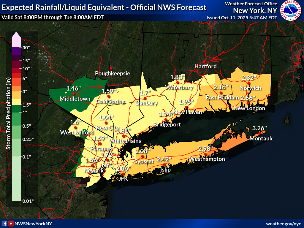
But that map is showing amounts 10x what it showed yesterday for inland places so who knows if its going to shift back the other way again but I agree on the other points -
 That Ocean / Monmouth County area has been targeted for several runs on various models for the heaviest rains. Overall this map does not look out of line and is about what I'm expecting. Maybe boost the totals some for LI? Strong onshore winds always were going to be the main feature of this event along with associated moderate to perhaps major coastal flooding especially NJ coast / bays. Solid beach erosion is going to take place over 3 three high tide cycles. I think inland winds are overdone but would not be shocked to see some gusts to 60 mph+? along the NJ coast. Expecting up to 30 mph up in my neck of the woods.
 - Today
-
 Wild per hourly forecasts gusts start about 11 am Sunday and end about 11 pm Monday. Not often to have that long of a winds even 35+mph gusts.. Tuesday shows gusts in the 30s too so I'll add that onto such a long wind event.
- 258 replies
-
- 1
-

-
- heavy rain
- damaging wind
- (and 2 more)