All Activity
- Past hour
-
Records: Highs: EWR: 86 (1956) NYC: 84 (1956) LGA: 83 (2021) JFK: 82 (1975) Lows: EWR: 32 (1937) NYC: 32 (1876) LGA: 39 (2009) JFK: 37 (1999) Historical: 1608: Evangelista Torricelli, the Italian physicist and mathematician who invented the barometer was born on this date. In 1644, Evangelista Torricelli, built the first barometer with mercury. The aneroid barometer was made first in 1843, the French scientist Lucien Vidie invented the aneroid barometer. (Ref. AccWeather Weather History) 1876: Snow fell on the backside of a coastal storm from Virginia to New England. New York City, NY had its earliest 32° temperature and a half inch of snow. Fall River, MA reported 3.5 inches of snow. (Ref. AccWeather Weather History) 1880: This was the beginning of what was called the Mid West "Snow Winter of 1880-81". People were trapped in their homes and by the end of the winter it was reported snow was around 11 feet deep. 1880 - A violent early season blizzard raked Minnesota and the Dakotas. Winds gusted to 70 mph at Yankton SD, and snow drifts 10 to 15 feet high were reported in northwest Iowa and southeast South Dakota. Saint Paul MN reported a barometric pressure of 28.65 inches on the 16th. Railroads were blocked by drifts of snow which remained throughout the severe winter to follow. Gales did extensive damage to ship on the Great Lakes. (15th-16th) (David Ludlum) (The Weather Channel) 1947: People question attempts to weaken a hurricane by seeding it with dry ice after it made an unexpected turn off the coast making landfall near Savannah, GA with winds of 100 mph. One person was killed. Damage totaled $3 million dollars. (Ref. AccWeather Weather History) 1954 - Hurricane Hazel struck the Carolina coastline. The hurricane demolished every pier along a 170 mile stretch from Myrtle Beach SC to Cedar Island NC, and obliterated entire lines of beach homes. Hurricane Hazel also destroyed 1500 homes as it moved inland with seventeen foot tides. Winds between Myrtle Beach SC and Cape Fear NC gusted to 150 mph. Hurricane Hazel caused 163 million dollars damage, and claimed the lives of 98 persons. (David Ludlum) (The Weather Channel) 1954: By 11 pm on the 15th, Hurricane Hazel had reached and crossed the waters of Lake Ontario, still sporting sustained winds as high as 60 mph. Hazel took direct aim at the heart of Toronto as it roared past at 49 mph. Toronto saw heavy rainfall before Hurricane Hazel on the 14th. The previous storm, in combination with the hurricane, resulted in significant flooding. 1966 - Iowa experienced its worst late season tornado of record. In just one minute a twister tore through the town of Belmond leveling 75 percent of the businesses, and 100 homes, causing more than eleven million dollars damage. (The Weather Channel) 1984: The Monday Night Football game in Denver, Colorado, was played in a raging blizzard. 15 inches of snow fell with up to 34 inches reported in the nearby mountains. The Air Force Academy canceled classes for the first time in its' recorded history. 1987 - Unseasonably cold weather continued in the eastern U.S., with thirteen cities reporting record low temperatures for the date. The low of 34 degrees at Montgomery AL was their coldest reading of record for so early in the season. Lows of 32 degrees at Harrisburg PA and 34 degrees at Parkersburg WV marked their third straight morning of record cold. (The National Weather Summary) 1988 - The cold high pressure system responsible for the record low temperatures in the eastern U.S. began to move out to sea, giving way to a trend toward "Indian Summer". Thunderstorms developing ahead of a cold front produced golf ball size hail at Altamont KS and hail two inches in diameter at Yates City IL. (Storm Data) (The National Weather Summary) 1989 - Hurricane Jerry made landfall at Galveston, TX, at 6 30 PM (CDT). Winds at the Galveston Airport reached 75 mph, with gusts to 100 mph. Tides along the island were six to eight feet, and rainfall totals ranged up to slightly more than six inches north of Beaumont. Three persons were killed when their vehicle was blown off the Galveston seawall into the pounding surf. Total damage along the Upper Texas Coast was estimated at fifteen million dollars. Thunderstorms produced severe weather in Lower Michigan during the late morning. Two persons were injured when a tree fell on their camper at the Traverse City State park. While strong northerly winds ushered much colder air into the central U.S., unseasonably warm weather continued in the south central and eastern U.S. The afternoon high of 82 degrees at Bluefield WV was a record for October. (The National Weather Summary) (Storm Data) 2005: On this date through the 17th, the summit of Mt. Washington, NH reported 34 inches of snow. The 24-hour record for the most snowfall occurred when 25.5 inches fell in 24 hours. (Ref. Wilson Weather History) (Ref. WxDoctor)
-
64 / 47 partly cloudy. Cooler today mid 60s in warmest spots we jump back up to the 70s tomororw (mid 70s max) ahead of the 48 cill this weekend with lowest temps since April 30s and perhaps some 20s inland. ig ridge goes north and west with persistent onshgore flow and cut off low off shore, still overall warmer for the period 10/19 and beyond and the days when flow comes around should see more 70s warmer.
-
We hope and pray, but deep down it sails away.
-

2026-2027 Record-breaking El Nino
bluewave replied to Stormchaserchuck1's topic in Weather Forecasting and Discussion
Multi-year La Ninas prior to 2018-2019 didn’t produce persistent record ridging east of Japan leading to the record upper ocean heat through the 2020s. So are correct this pattern is not being caused by the canonical -PDO of the past which was defined more by cooler SSTs in the EPAC rather than historic warmth east of Japan. It’s a whole new type of pattern outside the typical PDO. This new type of mid-latitude ridging pattern was able to persist through the spring into the present. It’s described in the papers as Pan-Basin warming overshadowing the robust Pacific Decadal oscillation. So it’s the overlapping influence of this new pattern combined with the the super El Niño forcing leading to the ridges being much stronger further to the south than has been in the case during past developing super El Niño springs into the fall. Pan-basin warming now overshadows robust Pacific Decadal Oscillation https://www.nature.com/articles/s41558-025-02482-z Remarkable Changes in the Dominant Modes of North Pacific Sea Surface Temperature https://agupubs.onlinelibrary.wiley.com/doi/full/10.1029/2022GL101078 -
ready 2 WAD
-
EURO had a powerful coastal storm at 0z and legitimately lost the whole thing at 6z
-
So are we gonna have a nor Easter this weekend or is it going to be beautiful? Models have flipped and flopped (besides GFS which has held firm with no storm)
-
I'm never confident we can say it's the last of anything. I mean yeah by Thanksgiving but can still get 70s and high dewpoints for a while
-
The moisture is welcome in whatever form it falls.
-
too soon
-

2026-2027 Record-breaking El Nino
LakePaste25 replied to Stormchaserchuck1's topic in Weather Forecasting and Discussion
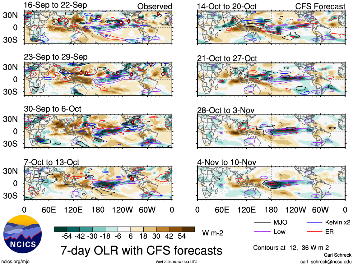
The mean convection will sit where it’s 30C, however the MJO will wobble it around a little. You can see here with the black outline how it can destructively and constructively interfere. MC is pretty much shut down here even with the MJO near it, but once it moves east of the MC, it can fire up areas slightly west or east of the 30C standing wave, or in the case of the 11/4 to 11/10 frame, sit directly on top of it and further enhance the 30C warm pool convection.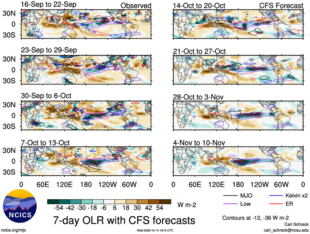
-
 https://cangetrx.shop/# canadian drugstore online
 -
Pretty good call. Looking likely that snow will mix in or change over briefly late overnight into early morning. Could possibly see a trace...?
- Today
-
100% toss…for now. GDM is pretty bullish on a storm developing off the coast, it just doesn’t bring it anywhere close to us.
-
Tomorrow has got to be the last muggy day of the season right? I suspect dew point records to be smashed tomorrow.
-

Mountain West Discussion
mayjawintastawm replied to mayjawintastawm's topic in Central/Western States
0.18" storm total rain, anything more would be good in any form. -

Occasional Thoughts on Climate Change
Typhoon Tip replied to donsutherland1's topic in Climate Change
I didn't shift anything. Nor have I been in your debate, guy - merely made the observation that people have different ideas on the nature of what a existential threat is - time and imminence being a part of that. By the way, you are factually wrong much of the time. "- it has very much *not* been due to global warming; " garbage semantics. Climate-related die-offs are happening now. If you want to dodge acknowledgement by saying they’re not all caused by climate change alone that's elementary anyway, but doesn't work to abase the former. I also said the toxicity ( meaning pollution) plays a roll. Either way, this can and should all be under anthropomorphic activity. That's not 'goal posts', that's intelligence. It is divisive to attempt to do otherwise, that or ignorance, anyway, because the use of fossil fuels for combustion creates toxicity, in conjunction green-housing... But as far as temperature specifically, a clear current example is coral reefs: NOAA reports that the fourth global coral bleaching event affected about 84.4% of the world’s coral reef area with bleaching-level heat stress between January 2023 and September 2025. Plus, I spoke of diasporas in that, too - which is species migrations... which is evidentiary supporting the same notion. There's plenty of others, and I'm not going to do the petty low-brow game of citing them for you - go do the research. More broadly, warming and extreme weather are already affecting wildlife and this is just flat empirical fact. Habitat loss, disease, and other pressures are scienced and heavily papered. -

2026-2027 Record-breaking El Nino
40/70 Benchmark replied to Stormchaserchuck1's topic in Weather Forecasting and Discussion
To be fair, models have also be underestimating that warm pool east of Japan, which is the primary driver of the residual -PDO...so that goes both ways...can be said for both competing forces. -
Occasional Thoughts on Climate Change
Typhoon Tip replied to donsutherland1's topic in Climate Change
...there's also a moral consideration... It's one thing to be a hunter, with a gun or arrow ... traipsing through the bush stalking stock for the winter. Not to sound too 'out there' but to for brevity, "Gaia" set that table of predator-prey relationship since the beginnings of life some billions of years ago. Obliviously swiping ecologies clean from a smoke stack 10,000 miles away ... I'll tell ya, at a minimum that's an interesting philosophy for the process of global Darwinism. you know? strong survive and so forth. It just seems, however, that's an overstep on "evolution's intent" - poetically... who deserves reprisal? How's that for a creepy prelude. haha Anyway, an "existential crisis" should include all species of the planetary system, not just human kind. Particularly considering ... the holistic system ..."Gaia" or whatever you wanna call it, has to be healthy if and when our technology can't keep up if/when our own adaptation rate is being tested. The world is experiencing a mass die off, and it is inextricably connected to CC. Anthropomorphic culpability in that die-off is, in a clinical sense, an incredible achievement by the machinery of Darwinian heh... It smacks of that stuff about how technological feedback creates a paradox, 'Evolution evolves the means to de-evolve the progenitor to the previous state'. Basically, tech makes survival easy; "easy" stops Darwinism; traits dissolve away because nature never holds onto attributes - entropy ensures decay. That's at least one plausible explanation for Fermi's Paradox right there. I'm sure there's more direct means ...like, species A can't survive their technological infancy before blowing themselves to kingdom come ... If we survive the dad's gun scenario, we have this slow cook Law of Lessening Returns. CC and the perils in store ... it reminds me of that "Star Trek: Next Generation" episode, "The Ensigns of Command". In that episode, a kind of xenophobic alien antagonist species known as "Sheliak" claim rights to a planetary system where several generations of colonist had adapted and were surviving - naturally ... not wanting to yield to the Sheliak's demand. Meanwhile, the Sheliak make it clear they would be willing to exterminate the "infestation", apparently having no compunctions in doing so... The colonist have technology, but they are vastly inferior, as well, had been completely closed off from the Federation for over a hundred years, and therefore, had sort of devolved to this incredulous state ... Implicit in the plot is that they can't see the Sheliak threat so they don't believe it to be what it is purported to be in lieu of the majesty they can see, which is their proud achievement as a surviving colony. The episode is a Sci Fi story exploring sociological aspects - really quite fascinating. "Data" ( Brent Spiner), essentially a cyborg life form, was the only crew member that could withstand the "hyperonic" ( whatever that is/means) radiation the colonists themselves learned to adapt to, so he, being the less human of lot is naturally charged with the responsibility of exposing and convincing these people, first hand, of the existential threat the Sheliak impose... Things aren't going so well. He is even violently opposed to for his typical ingratiating uber polite methodical approach and efforts... But the true hero is a sympathizer and realist member of the colony that restores him from a 'shut off' state, just in time! He rises to demo the Sheliak's ability, first hand, by destroying the aqueduct that feeds the colony by use of his modified phaser. Heh, everything in Start Trek is always solved by phasers or triquarters. Stunned by the power of what the phaser did, Data seizes the moment and tells them that the Sheliak will obliterate them from space, 'Without you ever having seen the faces of your annihilators'. In other words, tell a human they are in danger, they'll look around and float trial balloons. If they see it happening, they get out of the way. At last, the colonists acquiesce. I find all that strikingly metaphoric where, just because humanity cannot real see, feel or sense the danger of CC directly, they are more than willing to deny the peril of it as being real. -
2026-2027 Record-breaking El Nino
40/70 Benchmark replied to Stormchaserchuck1's topic in Weather Forecasting and Discussion
Yea, we'll just have to see. I understand that....this is why it wouldn't be wise to hedge towards an outcome as severe as 1965, in addition to CC, of course. -
39 degrees and rain. Reminds me of many a Maryland winter when it's puking snow 10 miles to my west.
-
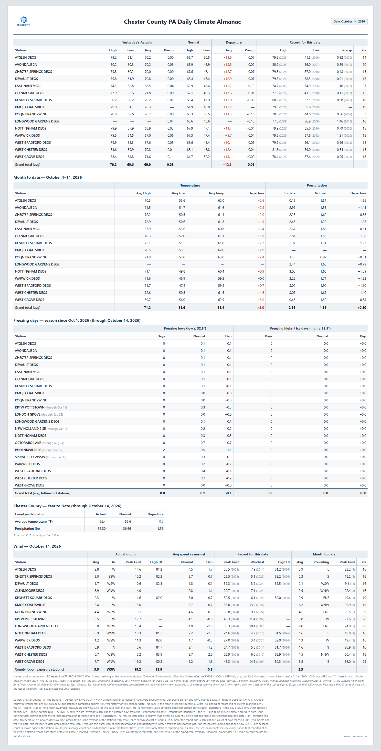
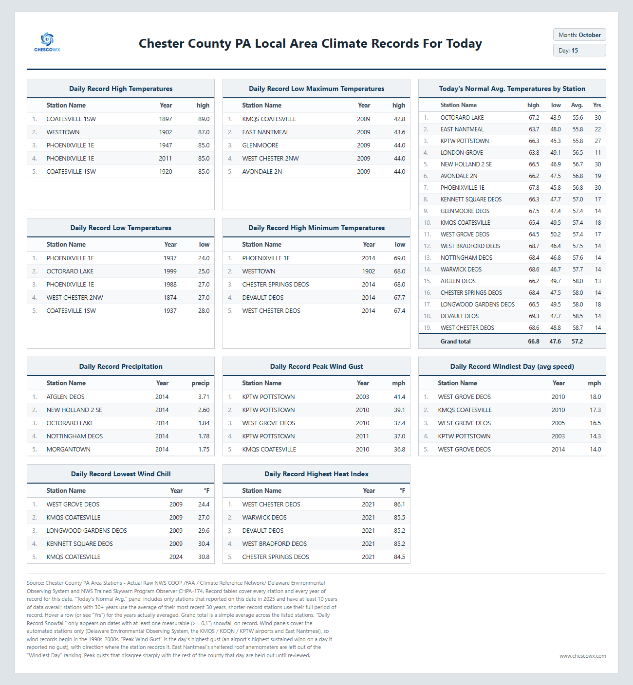
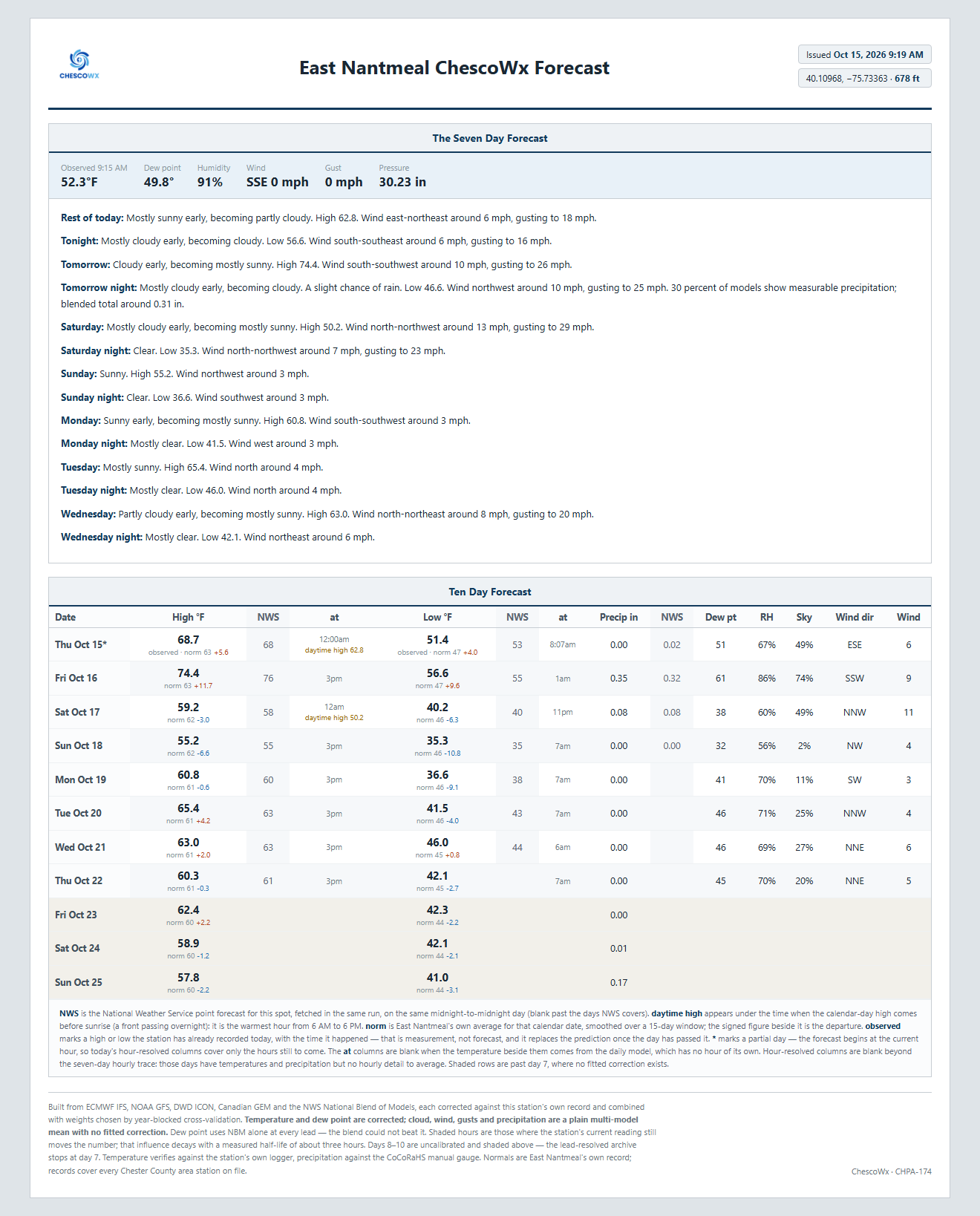
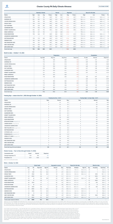
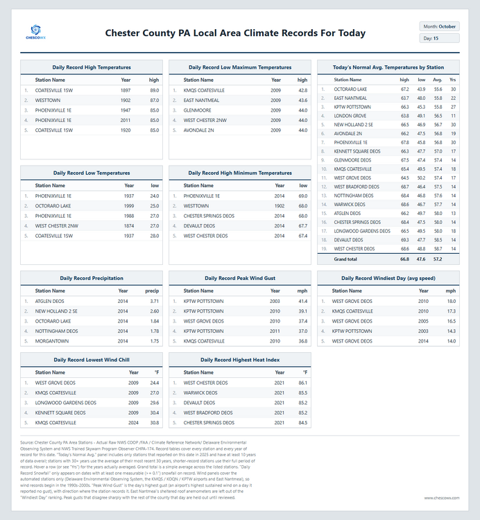
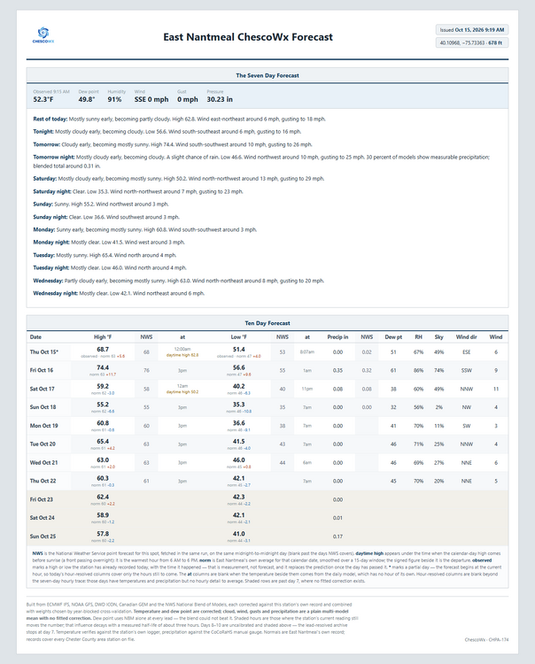
Of note 72 years ago today back in 1954 Chester County was on the last day of a 2 day storm that left as much as 1.60" of rain at Coatesville 1SW. This was the remnants of Hurricane Hazel which tracked within about 80 miles of the county. Today we should see highs in the upper 60's to near 70 which is about 5 degrees above normal with lows tonight in the 50's. Temperatures will run about 11 degrees above normal Friday but by Saturday we drop to 4 to 9 degrees below normal, before we return to near normal by Tuesday. By Sunday morning lows will be in the low to mid 30's with a freeze possible in the colder valleys! Our best chance of rain is Friday with around 0.30" according to the ChescoWx model.
-
(002).thumb.png.6e3d9d46bca5fe41aab7a74871dd8af8.png)
E PA/NJ/DE Autumn 2026 Obs/Discussion
ChescoWx replied to PhiEaglesfan712's topic in Philadelphia Region
Of note 72 years ago today back in 1954 Chester County was on the last day of a 2 day storm that left as much as 1.60" of rain at Coatesville 1SW. This was the remnants of Hurricane Hazel which tracked within about 80 miles of the county. Today we should see highs in the upper 60's to near 70 which is about 5 degrees above normal with lows tonight in the 50's. Temperatures will run about 11 degrees above normal Friday but by Saturday we drop to 4 to 9 degrees below normal, before we return to near normal by Tuesday. By Sunday morning lows will be in the low to mid 30's with a freeze possible in the colder valleys! Our best chance of rain is Friday with around 0.30" according to the ChescoWx model.
-
100% correct. The hockey stick chart and average lifespan chart, if laid on top of one another, nearly match, but yeah, we are going to die off because of C02 and all that came from the industrial revolution is going to kill us all.
-
2026-2027 Record-breaking El Nino
bluewave replied to Stormchaserchuck1's topic in Weather Forecasting and Discussion
I also agree with Snowman that the forcing could be stronger further east than the models are showing since this is such an extreme event.