All Activity
- Past hour
-
Made it to 90 for the second day in a row. Car was reading 94 as I was driving through Philly to the Mets game
-
It's happened a lot here at the coast after hitting 100 around 12 noon or 1 pm. Around here we're used to peaking around that time, usually we outpace the city and even Newark sometimes by several degrees. Then the temperature starts to drop around 4 pm and then it levels out in the early evening and sometimes even starts to rise again after that.
-
Yeah the warm spots will still be above 90 at 10pm Tuesday
-
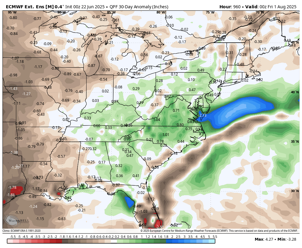
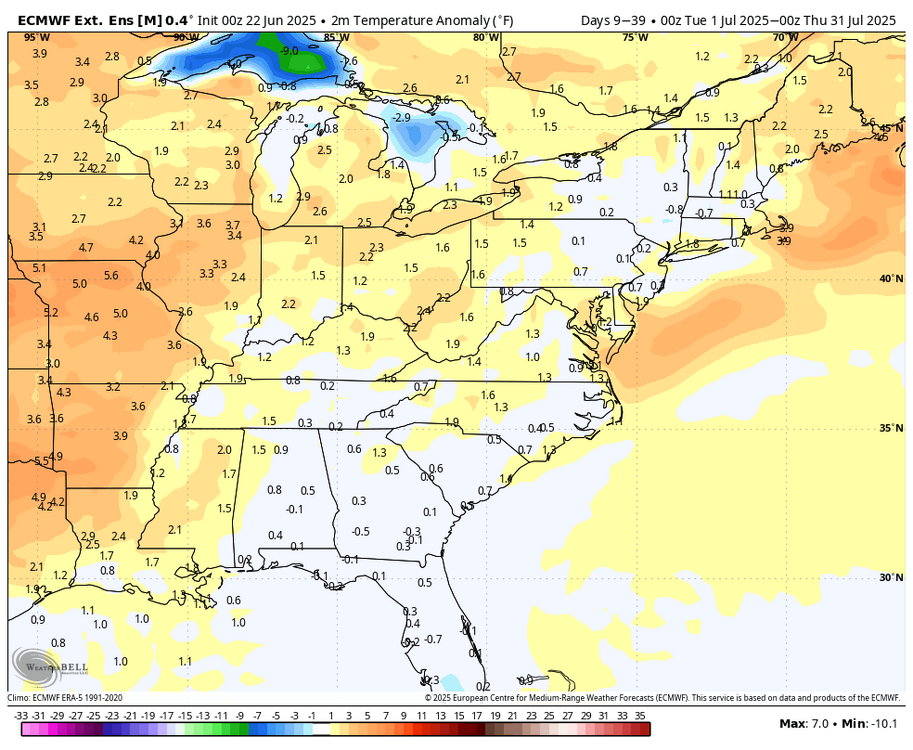
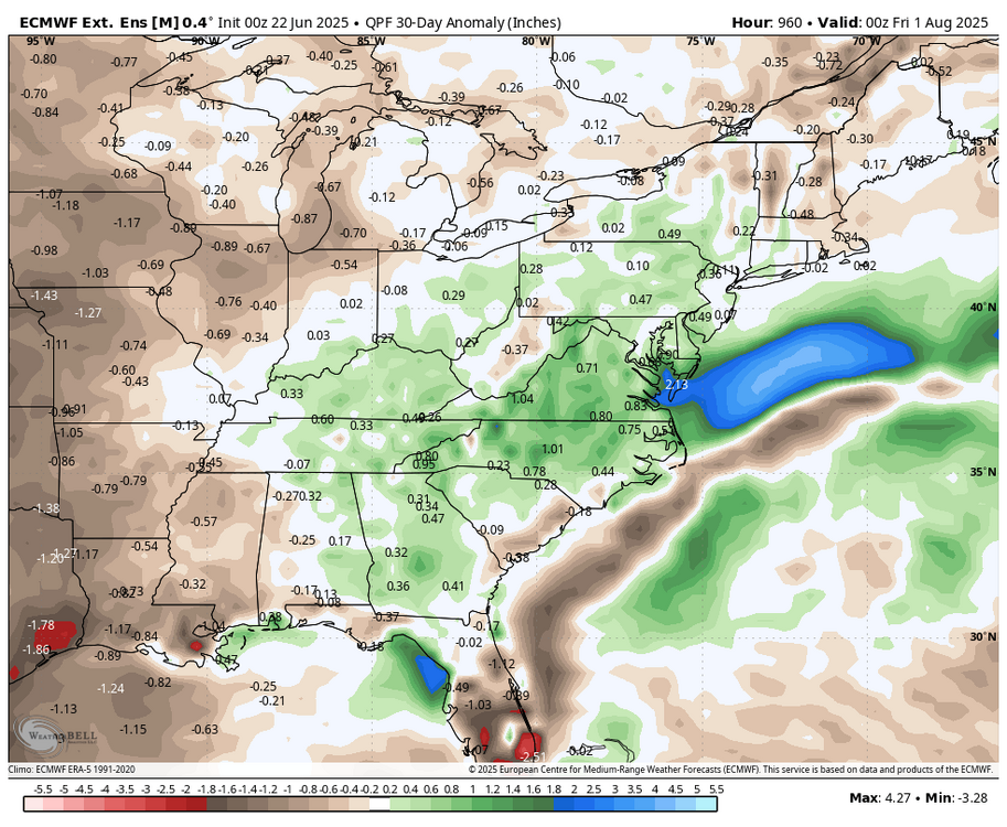
WB latest weeklies for 30 day period (July).
-
When you're 95 to 100 you don't expect to be in the mid 80s by 5PM. A couple models have 70s. One of the worst parts of heatwaves in the city is the temps staying at absurdly high levels deep into the night. Being 80 degrees at 5PM is actually quite comfortable lol I wouldn't call that normal for a "major heatwave"
-
90/DP76 at 5:44 PM cloudy HI 102 Fun times! And this is the 'cool' day. Hello, D.C. summer!
-
Late high here 88/74 as of 5:30 pm, heat index up to 97.
-
High of 91 today
-
I hope we have this westerly wind for Tuesday so JFK can hit 100 in June!!
-
These folk love heat and high dews so much that many of them have spent the day posting from inside of their air conditioned homes...
-
lets just hope we dont get any clouds Tuesday afternoon
-
This is kind of normal, it will be in the 80s by Monday evening and stay at 80 or above all night. Nice launching pad for Tuesday.
-
so they hit 90 today? strange, yesterday I hit 90 and they did not. today they hit 90 and I didn't (89 here)
-
90.4 degrees, second 90 of the season
-
I asked myself if I should go back and change that as I posted it lol. Most people are in the 80s by Monday evening.
-
89 unofficially here at CBP.
-
87 here. Looks as if we're not gonna make it to 90. Never would've thought that yesterday would be hotter than today, but of course the models missed the fact that the rain/clouds would make it this far south today. So that messed up what should have been a 5 day heat wave here.
-
Car says 100. House says 98.
-
Following this morning's showers and thundershowers, heat began surging into the region. Through 5 pm, highs at JFK Airport and Newark had reached 91°. Extreme heat is likely tomorrow, Tuesday, and possibly Wednesday Temperatures will likely top out in the middle and upper 90s in the New York City area and upper 90s to lower 100s in the hot spots in New Jersey during the height of the heat on Tuesday. The ECMWF and GFS continue to show potential June monthly record heat for parts of the region. June Monthly Records: Bridgeport: 97°, June 9, 2008 Islip: 96°, June 24, 1966 and June 19, 1994 New York City-Central Park: 101°, June 29, 1934 and June 27, 1966 New York City-JFK Airport: 99°, June 29, 1949, June 26, 1952, June 30, 1964 New York City-LaGuardia Airport: 101°, June 26, 1952 and June 13, 2017 Newark: 103°, June 27, 1952 June 26, 1952 is currently the hottest June day on record in and around the New York City area. Out of the five stations from the above list that were operating in 1952, three reached or exceeded 100° on June 26, 1952 (Central Park: 100°, LaGuardia Airport: 101°, and Newark: 102°). All five reached 95° or above. Two stations also saw 80° or above lows: Central Park: 81° and LaGuardia Airport: 84°. Both the number of 100° highs and 80° lows is the highest on record for June for this five-station area. For June 26, 1952, the five-station average high was 99.4°, the average low was 78.2°, and the mean was 88.4°. The average high and mean are the highest on record for June. The average low is the second highest on record for June. June 21, 2012 was the second hottest day, overall, in this region. Its average high was 96.8°. Its average low was 78.4°. Its mean was 87.6°. That average low was the highest on record for June. The average high and mean were the second highest for June. The ENSO Region 1+2 anomaly was +0.5°C and the Region 3.4 anomaly was 0.0°C for the week centered around June 11. For the past six weeks, the ENSO Region 1+2 anomaly has averaged +0.30°C and the ENSO Region 3.4 anomaly has averaged -0.05°C. Neutral ENSO conditions will likely continue through at least late summer. The SOI was +8.58 yesterday. The preliminary Arctic Oscillation (AO) was +0.777 today. Based on sensitivity analysis applied to the latest guidance, there is an implied 79% probability that New York City will have a warmer than normal June (1991-2020 normal). June will likely finish with a mean temperature near 73.4° (1.4° above normal).
-
Hit 92 here and then the clouds capped things but the dews came up nicely. Was at my niece's graduation party and in the shade with the breeze it was hot but tolerable.
-
Steady temp at 90 dew 73
-
In South Philly for tonight's game - drove through a monsoon on Rt. 41 in Cochranville and saw a ton or tree damage in Chatham.
-
This post by you amarshall, is by far one of the finest and most classiest I have ever read on any forum, anywhere, in the past 20 years. It's on my new phpBB3 SciWx Forum and on my new MediaWiki wiki. I am doing a lifewide review of everything in the past 60 years that I can remember and this post of yours is most assuredly top shelf. SNE/NNE Posters have got some of the most incredible stories of all time and I am archiving many of what I think are THE BEST in the past 20 years. Especially in the Skiing Thread here.
-
 Preliminary scoring for June 2025 based on latest posted estimates of final anomalies in previous post. FORECASTER ______________ DCA_NYC_BOS_east_ORD_ATL_IAH_cent_c/e_DEN_PHX_SEA_west__TOTAL Roger Smith ________________ 80 _ 80 _ 90 __ 250 __ 90 _ 90 _100 _280_ 530__90 _70 _ 90 __250 __ 780 RJay ________________________ 90 _ 90 _100 __ 280 __100_ 80 _ 80 _260_ 540__80 _60 _100 __240 __ 780 hudsonvalley21 _____________ 92 _ 92 _ 90 __ 274 __ 78 _ 74 _ 60 _ 212_ 486 __74 _90 _ 84 __248 __ 734 wxallannj ___________________ 96 _ 94 _ 98 __ 288 __ 60 _ 92 _ 66 _ 218_ 506 __74 _76 _ 94 __244 __ 750 BKViking ___________________ 98 _ 96 _ 92 __ 286 __ 88 _ 56 _ 50 _ 194 _ 480 __96 _60 _ 82 __238 __ 718 Tom ________________________ 96 _ 92 _ 84 __ 272 __ 72 _ 84 _ 58 _ 214 _ 486 __70 _82 _ 96 __248 __ 734 ___ Consensus ______________96 _100 _ 92 __ 288 __ 76 _ 72 _ 60 _ 208 _ 496__74 _68 _100__ 242 __ 738 so_whats_happening _______ 94 _ 92 _ 92 __ 278 __ 78 _ 72 _ 60 _ 210 _ 488 __98 _66 _ 78 __242 __ 730 DonSutherland1 _____________92 _ 96 _ 96 __ 284 __ 98 _ 54 _ 56 _ 208 _ 492 __68 _66 _ 90 __224 __ 716 Stormchaserchuck1 ________ 92 _ 96 _ 90 __ 278 __ 66 _ 62 _ 54 _ 182 _ 460 __ 90 _94 _100 __284 __ 744 Scotty Lightning ____________80 _ 80 _ 60 __ 220 __ 60 _ 70 _ 70 _ 200 _ 420 __ 70 _80 _ 90 __240 __ 660 wxdude64 __________________76 _ 84 _ 78 __ 238 __ 58 _ 66 _ 50 _ 174 _ 412 __ 52 _ 48 _ 98 __198 __ 610 ___ Normal __________________60 _ 60 _ 50 __ 170 __ 50 _ 50 _ 40 _ 140 _ 310 __ 60 _ 40 _ 80 __180 __ 490 RodneyS ____________________50 _ 82 _ 70 __ 202 __ 14 _ 36 _ 64 _ 114 _ 316 __ 62 _ 42 _ 98 __202 __ 518 _________________ Persistence (May 2025) ____ 56 _ 42 _ 66 __ 164 __ 00 _ 56 _ 96 _ 152 _ 316 __ 66 _ 68 _ 70 __204 __ 520 ==================== EXTREME FORECAST report DCA, NYC, BOS, ORD all narrowly outside win-loss situation as third warmest forecasts have high scores. ATL at +2.5 would be a win for wxallannj (+2.1) and a loss for Roger Smith (+3.0) IAH at +3.0 would be a win for highest forecast Roger Smith DEN at +2.0 would be a win for so_whats_happening (+2.1) and a loss for StormchaserChuck (+2.5) PHX at +3.0 would be a win for highest forecast StormchaserChuck (+2.7) SEA is not close to an extreme forecast at present, estimate close to consensus.
 -
87 today...just a 7 degree miss on a 12 hour forecast.