All Activity
- Past hour
-
Bottom 3 most likely
-
https://www.meteonetwork.it/models/mjo/ I recommend Paul Roundy's site as well. You can look at the MJO in different portions of each month based off research. Both phases 7 & 8 have their best responses in weeks 3&4 of DEC https://www.atmos.albany.edu/facstaff/roundy/waves/rmmcyc/index200reg.html
-
What is the website for these ENSO based MJO plot composites. Thanks in advance
-
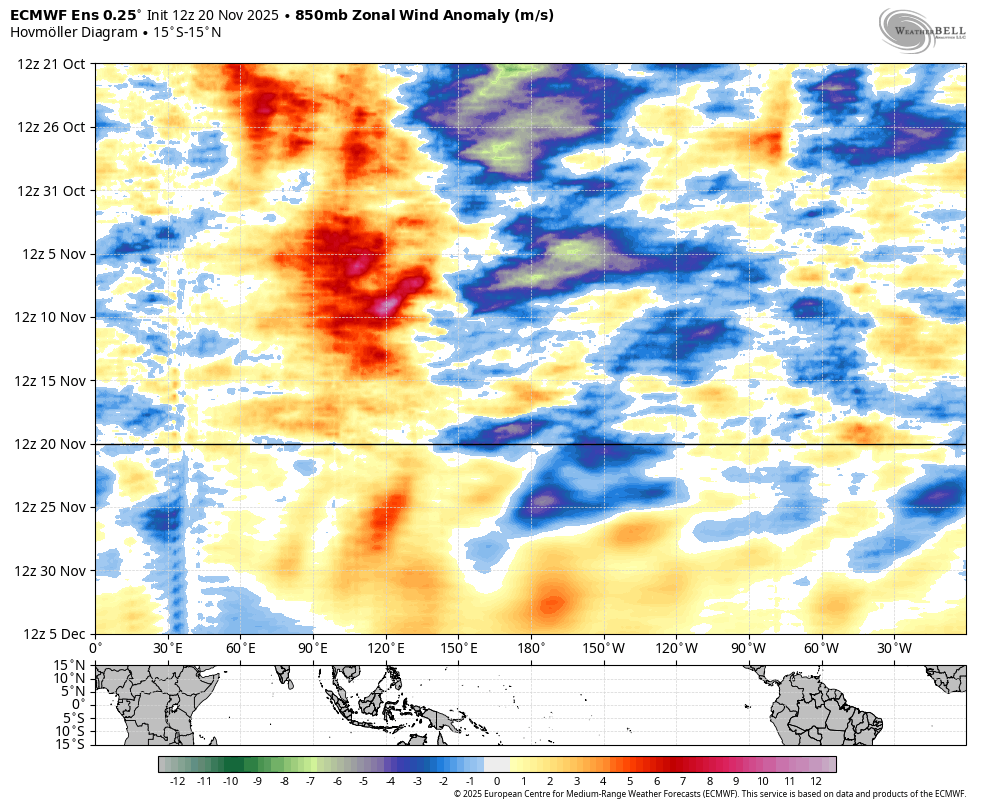
You are getting a MJO phase 8 with a SSW. Thats a cold wintry signal. December is going to be cold and to think we didn't need a volcano for that to happen. Many people are cautious which is fine but there are signals out there that the MJO will be going into 8.
-
BOM agrees...almost identical
-

November 2025 general discussions and probable topic derailings ...
Lava Rock replied to Typhoon Tip's topic in New England
doesn't work for me either, but could be our company firewall -
Getting a clean phase 8 pattern during December is going to be a challenge with any convection lingering near the Maritime Continent.
-

December 2025 Short/Medium Range Forecast Thread
Carvers Gap replied to John1122's topic in Tennessee Valley
The Euro Weeklies look like they have for the past 3-4 weeks which is cold weeks 3-6 w a warm up at the very end. They were prob a bit quick with the pattern change. They are about two weeks delayed from the original cold looks of a few weeks ago. For now, I think Dec 10 to just a few days after NYs looks BN for temps. For snow lovers, the concern would be cold and dry. The good thing about a +NAO is that the Gulf would likely be open for business. Could be warm up and rain…just have to time it with some of those inevitable highs coming from the prairies of MT. With a potential for SSW…we could see the cold hit 2-3 weeks after which would be an extension of cold into Jan. Model chaos on the horizon indeed. -
My goals before Christmas: Outstanding: multiple snow events, whether all advisory/warning/combination of these Great: One warning level snowfall event. Good: One advisory level snowfall event Bad: No snow Shut the Blinds: patterns fails and we get back to zonal puke
-
December 2025 Short/Medium Range Forecast Thread
Carvers Gap replied to John1122's topic in Tennessee Valley
IMHI, it really isn’t a Texas Blue Norther. That Euro cutoff partially pumps a ridge which locks all but the northern tier out of the cold during the first week of Dec. It is the Four Corners cutoff which drifts southwest into Baja and slowly runs out of steam…that is the pattern issue in my book. I am fine with a SW cutoff which eventually kicks out - pay me now or pay me later set up. The slow stall and drift into Baja is the thorn. The good thing is most ensembles get to the same EPO/PNA ridge setup by ~d14. The NAO(chuck mentions this in the MA) has gone poof, and that doesn’t push BN heights(over Canada) as far south as originally prognosticated. The Weeklies are only half completed as I type. I see Jeff has posted. Gonna hit enter and read it. -
Ok but if current ens guidance has the right idea, the combo of a +PNA/-EPO and a southward stretched TPV will begin to provide a mechanism for cold air transport southeastward for the first week to 10 days in Dec.. Beyond that there are hints of Scand ridging expanding into the NAO space- if that does happen and we end up with a -NAO, the cold will be in place underneath.
-

December 2025 Short/Medium Range Forecast Thread
nrgjeff replied to John1122's topic in Tennessee Valley
Deterministic models are pure chaos. Ensembles are flopping around but one can at least find some reasoning for that. After the Thanking cold a brief warmer episode is likely because of a little -PNA. However the Alaska ridge persists, so warmth probably won't. In fact by day 15 the EPS and somewhat GEFS hint at cross polar flow. Some support for return to cold mid-December, and perhaps lasting, comes from a retrograding Rossby wave. Since that's a 500mb feature we don't need to debate the SSW. Strato heights are well AN and want to reflect at 500mb. While I don't believe SSW wrecks cold patterns, it doesn't always favor North America. SSW signal is best for Eurasia. Things like the Rossby wave can turn odds for North America. The weekly charts may be picking up on all this. They go with the warmer week before settling into a colder regime with less back and forth. We'll see. Stuff changes every day. Who knows if all the background forecasts verify? At least the results make some sense this afternoon. -
The SE Ridge is kinda like SEC Football. You hate to see it coming, and you know its probably going to win in the end.
-

November 2025 general discussions and probable topic derailings ...
Cold Miser replied to Typhoon Tip's topic in New England
Looks good.
-
Till we actually don’t crap the bed, I expect us to crap the bed lol
-
It's always seemed to me looking at the extended that we would cool down briefly after Thankgiving and then warm back up the first week of December then potentially turn much colder by the second week of December. There are some good signals. We shall see...
-
Hey maybe the PDO is tilting towards our favor?
-
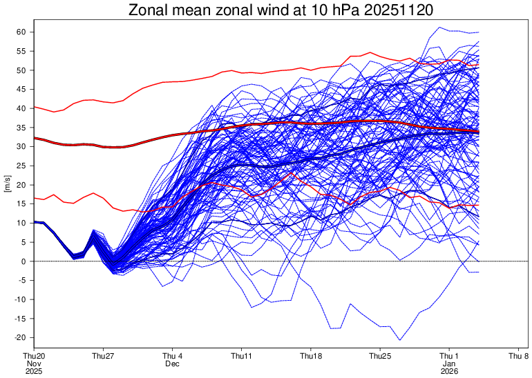
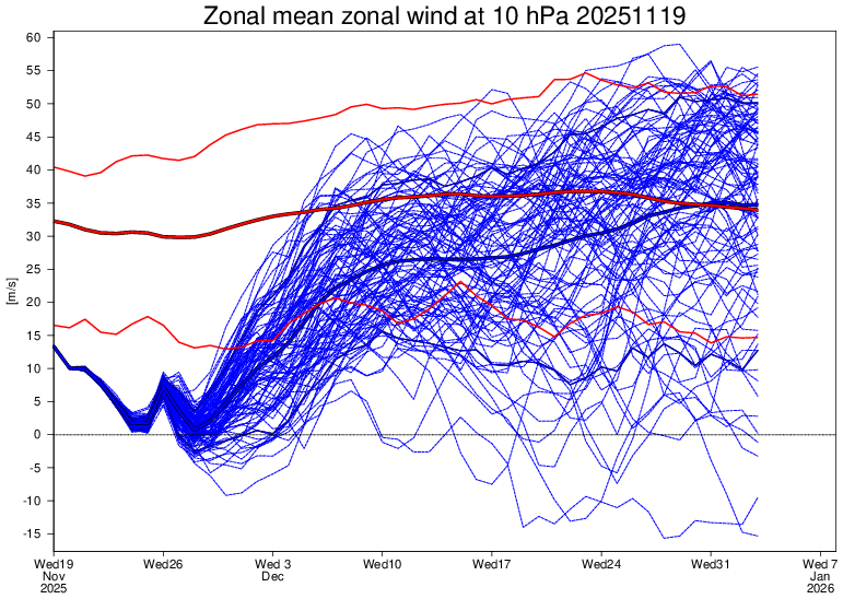
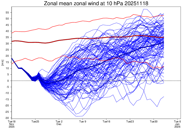
Today’s Euro Weeklies 10 mb zonal wind mean is slightly weaker early and allows most to reverse unlike yesterday. However, afterwards it looks like yesterday’s significantly stronger run: Today’s: Yesterday’s: Two days ago: significantly weaker
-

November 2025 general discussions and probable topic derailings ...
alex replied to Typhoon Tip's topic in New England
For those who complained... our new webcam is finally up! We moved it, now you can see the ice skating rink and my house, with West Mountain in the background. https://www.brettonwoodsvacations.com/webcam/ -
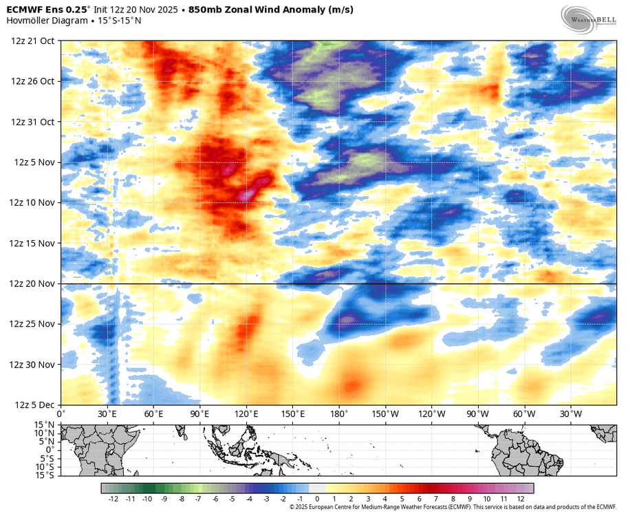
It is probably just picking up a weak signal from the Indo-pacific warm pool. I would be more worried about it if p8 was not propagating as a strong KW. Note the WWB associated with the P8 pass through, which is what we typically see with weakening Nina’s.
-
The fly in the ointment right now for the holidays is a lack of a -NAO. It's tough to get a big snowstorm without that feature to hold a storm closer to the coast. I'm not unhappy by any stretch of the imagination though...it beats Pacific Puke with 580dm heights across the entire CONUS!
-

December 2025 Short/Medium Range Forecast Thread
Daniel Boone replied to John1122's topic in Tennessee Valley
The one bias we hope turns out to be the case here is the Euro holding energy back in the SW. -
December 2025 Short/Medium Range Forecast Thread
Daniel Boone replied to John1122's topic in Tennessee Valley
That was my worry when I alluded to SW Trough yesterday. -

Central PA Fall Discussions and Obs
Voyager replied to ChescoWx's topic in Upstate New York/Pennsylvania
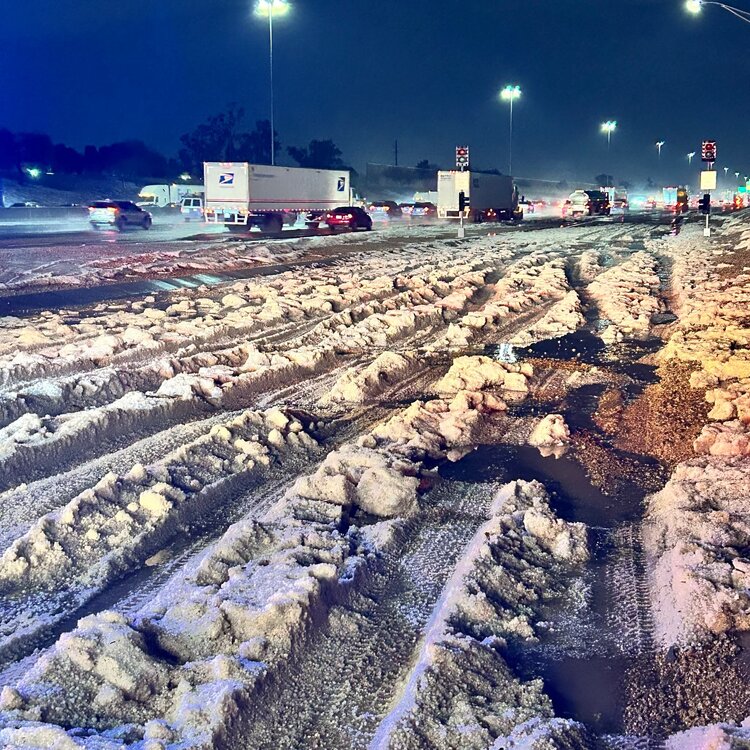
This may look like snow, but it's actually hail from a wild severe thunderstorm that hit West Phoenix in Arizona yesterday. This is the entrance ramp to I-10 from 83rd Ave.