All Activity
- Past hour
-

Friday February 6 FROPA / WINDEX small event
wxeyeNH replied to HoarfrostHubb's topic in New England
About 2.5" here. Winds are very light at the moment. Almost calm. We have had very little wind with this system. Boy, some impressive wind and cold to our southwest. -
And this will to change again and again. I find it hilarious ( and this is not directed at you at all ) that there are posts from people within the same day where in one sense they're freaking out, and then a post about 4 hours later they are cheering on what the models are showing. Point is, as we've seen all winter long, things are going to change within the course of 2 or 3 days before an event. People need to take a chill pill and relax.
-
yeah D11-15 is still later February and even then, those cold shots are modifying and models will notoriously bias them too cold
-
Hopefully it jumps right to summer, 1 week of spring misery and then right to HHH and speedos on the boat. Everybody wants this.
-
11.3with light snow
-

February 2026 OBS & Discussion
donsutherland1 replied to Stormlover74's topic in New York City Metro
Here's how things stand: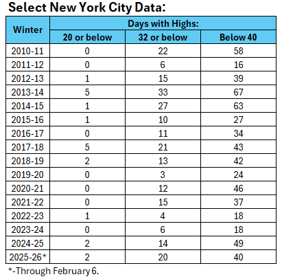
-
 Snippet from the LWX disco…. A stronger storm system may impact the area late next week (in particularly during the Thursday through Saturday timeframe). The cold front from Wednesday will stall down around the Gulf Coast states with several waves of low pressure set to caravan along it late next week into next weekend. The track and intensity of these low pressure systems remain uncertain as deterministic and ensemble guidance continue the "windshield wiper effect" of advertising a winter/rain storm or no storm across the region. Latest guidance suggest a system that passes just to the south and toward the coast with uncertainty in regards to temperatures, precipitation types, and amounts this far out. Continue to closely monitor the forecast as it will continue to change heading toward the Valentine`s Day holiday.
 -

Is we back? February discussion thread
Damage In Tolland replied to mahk_webstah's topic in New England
Two days ago it had a screamer.Tossed Use the machines -

Friday February 6 FROPA / WINDEX small event
Baroclinic Zone replied to HoarfrostHubb's topic in New England
Intensity down , looks like just lighter stuff left to go through. -

Winter Storm Threat *Technical* Discussion. No Op Run PBP or Snow maps
TSSN+ replied to CAPE's topic in Mid Atlantic
What’s the salary requirement for this thread? -
This cracked me up. Sometimes we all feel that way.
-

Friday February 6 FROPA / WINDEX small event
dendrite replied to HoarfrostHubb's topic in New England
Final was 3.5”/0.22” 16:1 with no clearings -
I would say A for cold definitely. For snow, meh. 2014, 2015, 2018, 2021 all had more. If we don't snow anymore rest of season, we're still below average. I doubt that would be the case but for me it's all about snowfall. If it's not going to snow, I'll take deep cold so at least it feels like winter. But ideally, 2021 was a great season. No crazy cold, but consistently snowy. That's the perfect winter
-

Is we back? February discussion thread
CT Valley Snowman replied to mahk_webstah's topic in New England
12z Euro Op is a Stein for SNE. Midweek is north and mainly light, next weekend gets squashed, then we cut and bleed towards the 18th and 19th. Another storm misses just south out in clown range towards the 21st. -
30 to 1 ratio! Light to occasionally moderate snow remains across the Twin Forks of Long Island as a vort max continues to rotate through the region as a negatively tilted upper trough moves slowly eastward. This upper trough along with a low level trough from offshore low pressure has combined to produce heavier snowfall earlier in the day. And with the cold airmass in place snow ratios have been running up to near 30 to 1, also contributing to the high snowfall totals. Between 18Z and 19Z radar reflectivities have been weakening. A Winter Weather Advisory remains in effect until 500 PM. CAMS and HRRR have been showing light snow lingering into early this evening. With the strong gusty winds and in areas with the higher snow totals, blowing snow will be possible, quickly reducing visibilities.
-

Friday February 6 FROPA / WINDEX small event
SouthCoastMA replied to HoarfrostHubb's topic in New England
Coming down pretty good..finally. Maybe I'll scrounge and inch or two -

Friday February 6 FROPA / WINDEX small event
40/70 Benchmark replied to HoarfrostHubb's topic in New England
Nah, I've been measuring regularly...just clear in 6 hour intervals. It's NBD...just an inch. -

February 2026 OBS & Discussion
[email protected] replied to Stormlover74's topic in New York City Metro
So far I would give this winter an A for cold and a B for snow. If it goes to 0 or below in Central Park this grade goes up to A+! I would consider 1993-94 the only A or A+ cold winter in my lifetime! -
2025-2026 ENSO
donsutherland1 replied to 40/70 Benchmark's topic in Weather Forecasting and Discussion
It continues into the start of March. The Southeast could have the lowest chance of seeing a return to cold conditions. The Middle Atlantic could be a battleground. -
Friday February 6 FROPA / WINDEX small event
Baroclinic Zone replied to HoarfrostHubb's topic in New England
I’m right on the western edge of that band.
-
Friday February 6 FROPA / WINDEX small event
40/70 Benchmark replied to HoarfrostHubb's topic in New England
I was down 8" in two weeks..most spots the same, I imagine...maybe inch or two less loss in the hills. -
Friday February 6 FROPA / WINDEX small event
Baroclinic Zone replied to HoarfrostHubb's topic in New England
Can’t guarantee I was not seen. -
February 2026 OBS & Discussion
[email protected] replied to Stormlover74's topic in New York City Metro
We are having a phenomenal winter in both of these departments! -
I had 1" before the wind. It snowed steadily from 8pm until around 9am. The town plow actually came by twice, once to slush things up and then a while later to scrape the shit into my driveway at 25mph. Fuggers...


