All Activity
- Past hour
-

2026-2027 Super El Nino
snowman19 replied to Stormchaserchuck1's topic in Weather Forecasting and Discussion
You almost forgot 57-58 and 65-66 lol Every time there’s an El Niño, no mater what, the weenie’s analogs are: 57-58, 65-66, 76-77, 77-78, 02-03, 04-05, 09-10 and 14-15!!! -
My backyard is covered in sticks
-

2026-2027 Super El Nino
Stormchaserchuck1 replied to Stormchaserchuck1's topic in Weather Forecasting and Discussion
I would say 72-73 and 23-24, although we risk the AO going more negative than those analogs. 15-16 would probably be my number 3 -

2026-2027 Super El Nino
LakePaste25 replied to Stormchaserchuck1's topic in Weather Forecasting and Discussion
What are the top analogs for this event? Let me guess: 09-10, 14-15, 04-05, 02-03, 76-77, and 77-78 -

2026-2027 Super El Nino
mitchnick replied to Stormchaserchuck1's topic in Weather Forecasting and Discussion
The fact that you would put in writing the last sentence is what you live for says it all about you. Just sayin'. And to think you denied it before last winter when I accused you of just that. -

2026-2027 Super El Nino
Cobalt replied to Stormchaserchuck1's topic in Weather Forecasting and Discussion
You’re really bold predicting that a Super El Niño in 2026 will be warmer than normal. I’m almost in shock, it takes a lot of guts to forecast something like that. -
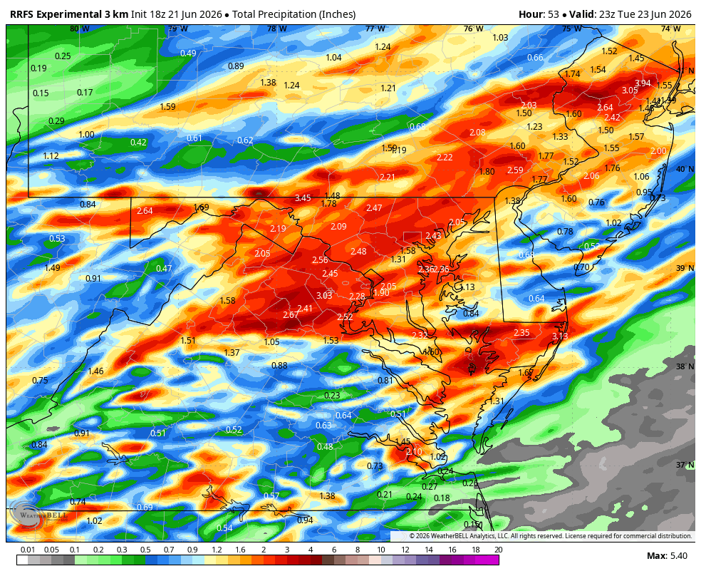
WB 18Z RRFS-Sold!

-
2026-2027 Super El Nino
mitchnick replied to Stormchaserchuck1's topic in Weather Forecasting and Discussion
Yep. So far, there are no seasonal forecasts that are undeniable furnace forecasts in the east, save maybe for NNE. But NNE can still get lots of snow with AN+ temps. -
Plant corn, get corn. Congrats
-
2026-2027 Super El Nino
snowman19 replied to Stormchaserchuck1's topic in Weather Forecasting and Discussion
Leave it to the usual cold and snow obsessed weenies on here and on twitter (i.e. Mark Margavage) to be wishcasting that 2009-10 is an analog for this winter with a raging super El Niño. Twilight zone. I’m literally in awe that people are actually suggesting that this is going to be a very cold winter. Talk about delusional and in deep denial This winter is going to be absolutely comical once the weenie meltdowns start Lmfaooooo -
Slight adjustments with slight and marginal Risks for today and tomorrow today marginal and slight moved more south westward to accommodate more of north and northwestern parts of Tennessee tomorrow the majority of Tennessee is under a marginal risk with a slight risk for Cumberland plateau and also (parts of?) East Tennessee .
-
Newton IL has a tornado, maybe in town
-
WPC has a slight risk of excessive rainfall and seems to indicate some areas could see 2+ inches of rain. "Current probs off the latest ensembles and National Blend indicate a large zone of 30-50% probs for >2" across the aforementioned area above with deterministic outputs closer to 2-3.5" into parts of Southern New England. The 00z HREF (only covers through 00Z 6/23) and 00Z REFS indicate 30-60% neighborhood probabilities for at least 2" per 6-hrs from D.C. to NYC and would be enough for some urban flash flooding concerns."
-
Why can't it just rain lol
-
These storms are just scraping by to my north and offshore..the season of haves and have nots has just begun. Maybe we can squeak out another quick pop up downpour or two like yesterday!
-
2 tornado reports in Illinois
-
-
What time frame we looking at the rain starting?
-
2026-2027 Super El Nino
Stormchaserchuck1 replied to Stormchaserchuck1's topic in Weather Forecasting and Discussion
How did the JMA initialize the current Nino (I know it has a west or central-based configuration in the Winter)? -
Shirtless, pantless and many packs of dude wipes on standby!
-
18z NAM looks like shit.
-

2026-2027 Super El Nino
michsnowfreak replied to Stormchaserchuck1's topic in Weather Forecasting and Discussion
Looks 2009-10ish. Interesting both jamstec and cansips are far from a warm winter. -
2026-2027 Super El Nino
Stormchaserchuck1 replied to Stormchaserchuck1's topic in Weather Forecasting and Discussion
Just letting you guys know, this was a >+1 PDO. The new thought in the weather community is that global warming is skewing PDO negative, etc, the warm pool near Japan isn't going away. While SSTAs are warmer, the PDO is a 50/50 index, and the big warmth along the west coast of North America was responsible for strong +PDO in 15-16. -
Very lucky that I will make it to July with hardly any heat this year!
-
Depending on instability there's a definite tornado threat here


.thumb.gif.f92b16c631a1d15d405ed77b33f0710d.gif)


