
All Activity
- Past hour
-
It’s happened every year. Just layer up, have another drink and vibe.
-

2026-2027 Record-breaking El Nino
jaxjagman replied to Stormchaserchuck1's topic in Weather Forecasting and Discussion
Those strong EWB'S the CFS shows into the IO is probably a sign where the MJO is at as we get further into Oct.This would cause a spike in the +IOD from MJO/ DWKW in which the IOD during boreal autumn peaks into fall sorta speaking,in a strong NINO.Only the strong NINO OF 97 ever saw the +IOD above +1,yet alone +1.39 that year -

October Comes Early: Late September Multi-Hazard Hybrid Storm
DirtySnowDen replied to WxWatcher007's topic in New England
It will shift north about 50-100 miles if every global is correct, take the blend and since the “trend is your friend”, this will rival the blizzard of 1978, minus the cold. Usually, anomalously cold temps and a kiss of tropical air are not forecasted well. -

October Comes Early: Late September Multi-Hazard Hybrid Storm
OrangeCTWX replied to WxWatcher007's topic in New England
ICON/RGEM both south of 6z, neither “land falling” info Long Island anymore. But RGEM was stronger than its previous run. -

Strong Nor'Easter/Hybrid Storm Late September 2026
pazzo83 replied to Rjay's topic in New York City Metro
Sandy had been a Cat 3 hurricane at one point and had a pressure around 940mb. This is not Sandy. -

Fall 2026 Medium/Long Range Pattern Thread
dwagner88 replied to John1122's topic in Tennessee Valley
We had a crazy gully washer on Wednesday. My PWS peaked out a 8.12"/hr. That is the highest rate I've ever recorded. It rained 2.18 inches in just over 20 minutes. Every detention pond in our subdivision was using the emergency spillways. -

October Comes Early: Late September Multi-Hazard Hybrid Storm
WxWatcher007 replied to WxWatcher007's topic in New England
Paging @Ginx snewx -
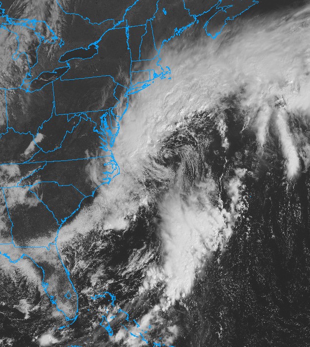
Looking pretty impressive on the latest Vis Sat image
-

October Comes Early: Late September Multi-Hazard Hybrid Storm
Typhoon Tip replied to WxWatcher007's topic in New England
You know ...there are certain things the NAM is good at - though they seldom if ever opportune to showcase for this forum. Namely, 'convective initiation' Another thing, I really like looking at the FOUS grid before winter storms. I know it's error and idiosyncratics. I apply those second nature on the fly and find those numerical aspects to be hugely useful for interpolating weather aspects. So it will be missed. I'm not trying to defend it's synoptic horror show ...particularly beyond 48 hours, no. But when this model goes away, there will be no FOUS gridded product from these other models to be acquainted with. -
Tropical storm condtions expected. Sounds like fun.
-

October Comes Early: Late September Multi-Hazard Hybrid Storm
MegaMike replied to WxWatcher007's topic in New England
What app/website is this from? I'm impressed that it has estimates from most major modeling systems. My only issue with it: mean(53.7+23.4+42.1+20.2+51.2+23.5+58.4+27.4+43.2+20.4+41.2+21.7+41.8+23.5) == 35.1mph I'm not sure where they're getting 17.8mph from. -
Septorcher 2026 Discussion - Endless Summer
dryslot replied to Damage In Tolland's topic in New England
I think the proper term was September ends summer........... -
October Comes Early: Late September Multi-Hazard Hybrid Storm
DirtySnowDen replied to WxWatcher007's topic in New England
The perfect storm. -

Strong Nor'Easter/Hybrid Storm Late September 2026
Stormlover74 replied to Rjay's topic in New York City Metro
Yeah the gusts are already approaching 40 mph -

Strong Nor'Easter/Hybrid Storm Late September 2026
jconsor replied to Rjay's topic in New York City Metro
WPC analyzed the low as 995 mb at 15z: https://www.wpc.ncep.noaa.gov/#page=sfc -

October Comes Early: Late September Multi-Hazard Hybrid Storm
tiger_deF replied to WxWatcher007's topic in New England
Definitely looks to be intensifying at a decent clip, core looks way healthier than even a few hours ago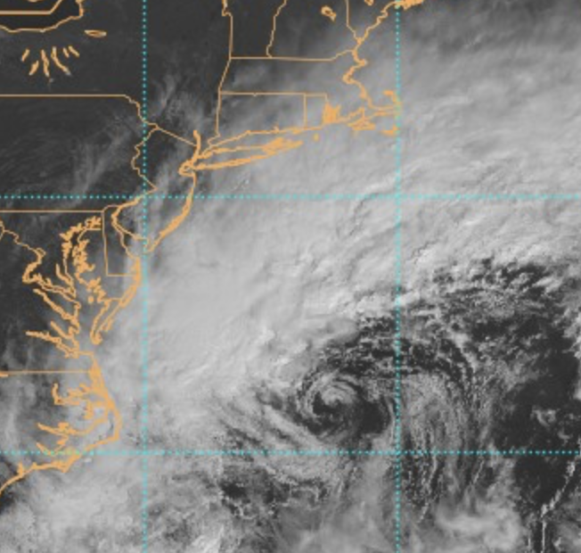
-
Strong Nor'Easter/Hybrid Storm Late September 2026
Stormlover74 replied to Rjay's topic in New York City Metro
Nam keeps going through Monday -

Strong Nor'Easter/Hybrid Storm Late September 2026
2112wxgrl replied to Rjay's topic in New York City Metro
It just became quite gusty outside and I’m way up in Wantage. My daughter and her college friends are headed to OC MD this evening. They’re supposed to go to Oceans Calling tomorrow. Today’s lineup was canceled. I highly doubt tomorrow’s show will happen. The high tides have been beating up the beach there for days now. -
Leaving Bethany now and headed to Rehoboth We shall see! who knows lol they’re busy setting up stages per beach cams
-
Should have recon data in an hour or so, NOAA2 took off a little while ago
-
October Comes Early: Late September Multi-Hazard Hybrid Storm
Typhoon Tip replied to WxWatcher007's topic in New England
Correct did that at 06 z too. Looks like there's a low out there ~ 995 mb, replete with a bent back warm front and dangling cold boundary, yet the NAM-aramadingdong thinks it's a 985 Cat 1 hurricane. -
October Comes Early: Late September Multi-Hazard Hybrid Storm
WxWatcher007 replied to WxWatcher007's topic in New England
995mb at 12z per WPC -
37 degrees at 7 am. .56" total rain last 5 days.
-

October Comes Early: Late September Multi-Hazard Hybrid Storm
dendrite replied to WxWatcher007's topic in New England
3k has 3” PWATS and saturated 0C at 500mb near the center. -
October Comes Early: Late September Multi-Hazard Hybrid Storm
OrangeCTWX replied to WxWatcher007's topic in New England
Did the NAMS initialize way too strong or am I making things up? I doubt this is currently a 988mb storm.






