All Activity
- Past hour
-

Jan 24-26 Weekend Snow and Sleetfest Model Thread Part Tres
WVclimo replied to H2O's topic in Mid Atlantic
4° with a DP of -11 wind chill of -9 -

Jan 24-26 Weekend Snow and Sleetfest Model Thread Part Tres
mitchnick replied to H2O's topic in Mid Atlantic
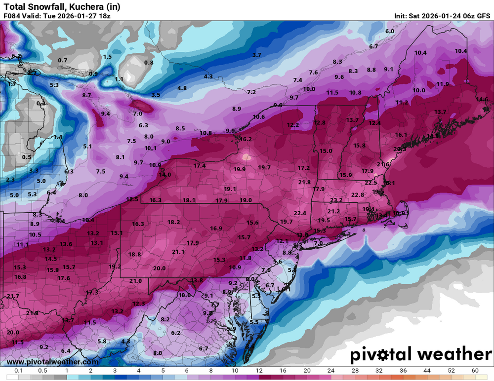
Just a reminder that the map is 10:1, so you would think Kuchera would increase it some. -
Vanishing act except for the gfs ai
-

Pittsburgh/Western PA WINTER ‘25/‘26
colonel717 replied to Burghblizz's topic in Upstate New York/Pennsylvania
-

Jan 24-26 Weekend Snow and Sleetfest Model Thread Part Tres
aldie 22 replied to H2O's topic in Mid Atlantic

-
Jan 24-26 Weekend Snow and Sleetfest Model Thread Part Tres
mitchnick replied to H2O's topic in Mid Atlantic
Actually, I was trying to convey that I didn't have the scientific answer myself with the emoji, but I would certainly think sleet comes in different shapes and sizes to effect accumulations some. But since sleet is generally 3:1, you probably wouldn't notice a big difference between 2.5:1 and 3.5:1. -

Extreme Cold, Snow & Sleet: SECS 1/25 - 1/26
WeatherGeek2025 replied to TriPol's topic in New York City Metro
where can i find this models radar composite? -

Extreme Cold, Snow & Sleet: SECS 1/25 - 1/26
nycsnow replied to TriPol's topic in New York City Metro
Really all depends on how fast the transition happens. If models are to fast even by a couple hours nyc Long Island can achieve 10-12 I have to imagine -
Jan 24-26 Weekend Snow and Sleetfest Model Thread Part Tres
aldie 22 replied to H2O's topic in Mid Atlantic
Thanks Mr. mix -

January 2026 regional war/obs/disco thread
codfishsnowman replied to Baroclinic Zone's topic in New England
Good. Clippers are good. You usually do pretty well with your predictions on them. -
Jan 24-26 Weekend Snow and Sleetfest Model Thread Part Tres
mitchnick replied to H2O's topic in Mid Atlantic
Not when you're selling the truth. Here's a link to the 6z GGEM. Also very close to 0z. https://meteocentre.com/numerical-weather-prediction/precipitation-accumulation.php?lang=en&map=qc&run=06&mod=cmc_gdps&hi=000&hf=120&type=SN&mode=latest&yyyy=latest&mm=latest&dd=latest&capa_verif=off -

“Cory’s in LA! Let’s MECS!” Jan. 24-26 Disco
Roger Smith replied to TheSnowman's topic in New England
-32F in parts of eastern Ontario and -36F in n WI, this high is going to feed extreme cold into the storm until the coastal bombs (to some extent, not that robust) ... I am thinking 20-25 inch potential in parts of e MA and 15-20 across n half of CT. Think there will be some reductions by sleet near Long Island Sound and across se MA south of Plymouth to New Bedford. Even so, 10-12" before the change there. Remember that storm (think it was Dec 2020) when Binghamton NY had 40" -- I wonder if there will be a location that gets that sort of outcome with this one? I would think New England rather than upstate NY if so (probably not 40" but perhaps one local 30"). Not too far from ORH would be my guess as to where that might happen. -

Southern Crippler - Get well soon Jimbo Storm Obs
WXNewton replied to BooneWX's topic in Southeastern States
IMBY-31.8/17 -
Jan 24-26 Weekend Snow and Sleetfest Model Thread Part Tres
aldie 22 replied to H2O's topic in Mid Atlantic
Come on man Im a milk man not a weather man -
January 2026 regional war/obs/disco thread
codfishsnowman replied to Baroclinic Zone's topic in New England
4 and Windy I'll take that calm wind fake cold any day! -

Extreme Cold, Snow & Sleet: SECS 1/25 - 1/26
jm1220 replied to TriPol's topic in New York City Metro
Yeah.... much as I would love that it's not going to happen. I think something like the RGEM is the high end for this. I'm not sure if these maps show sleet as snow so the 10-1 snow maps that are lame in general for us, you can probably add up to 2" of sleet on top so if it shows 6" for you, sleet could end up with 8" total. -
Pittsburgh/Western PA WINTER ‘25/‘26
colonel717 replied to Burghblizz's topic in Upstate New York/Pennsylvania
-

Southern Crippler - Get well soon Jimbo Storm Obs
Coach McGuirk replied to BooneWX's topic in Southeastern States
Make sure you have your flashlights and a radio ready. -

Jan 24-26 Weekend Snow and Sleetfest Model Thread Part Tres
Ji replied to H2O's topic in Mid Atlantic
-

Central PA Winter 25/26 Discussion and Obs
pawatch replied to MAG5035's topic in Upstate New York/Pennsylvania
Just my thoughts: I think the GFS and Euro has been pretty steadfast. Nam in the past has had a way of sniffing out the warm nose. But it’s kind of all over so far with this storm. So it wouldn’t be my choice. Most everyone is going to get a foot of snow so enjoy! I’m getting my tractor around for this storm and my big Ariens blower. Pace yourself cleaning the snow up. We don’t need any heart attacks. -
Jan 24-26 Weekend Snow and Sleetfest Model Thread Part Tres
Ji replied to H2O's topic in Mid Atlantic
Starting with the words rgem lost is bad marketing -
Some of you are going to wake up to a wonderful surprise. .
-
Extreme Cold, Snow & Sleet: SECS 1/25 - 1/26
nycsnow replied to TriPol's topic in New York City Metro
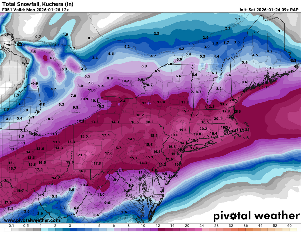
How do we get the RAP to verify? Lol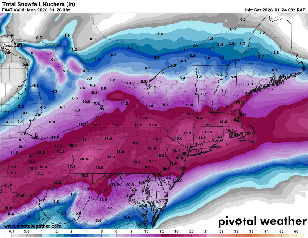
-
Jan 24-26 Weekend Snow and Sleetfest Model Thread Part Tres
Ji replied to H2O's topic in Mid Atlantic
Since you are at 4 degrees I I think you will have a 14:1 sleet ratio -

Extreme Cold, Snow & Sleet: SECS 1/25 - 1/26
Brasiluvsnow replied to TriPol's topic in New York City Metro
6 degrees in New City Rockland County right now. That said what indications will there be about how far North the midlevels will be warming without now casting and live reports is there anything else to look at ? As far as the radar and the position of the 2 lows right now at this moment which model appears to of had depicted what is taking place right now accurately = has there been any one model that has done a good job at predicting what things would be looking like along the coast right now as far as the the path and location of these 2 lows ?