All Activity
- Past hour
-
You can still get some cooler air, even with above normal temps in Canada
-
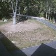
Nice day to head out on the Charles for some hunting.

-

2026-2027 Record-breaking El Nino
40/70 Benchmark replied to Stormchaserchuck1's topic in Weather Forecasting and Discussion
We have talked about this and it's the recent why I am employing the "reversal" terminology moving forward, rather than SSW to avoid these scientific inconsistencies. -
Where is this cold air coming from with Canada so hot ?
-
2026-2027 Record-breaking El Nino
40/70 Benchmark replied to Stormchaserchuck1's topic in Weather Forecasting and Discussion
On a national level, of course given the background warming in conjunction with how much OHC as built up to trigger this unprecedented El Niño, but I'm not concerned with that....no one in their right mind is disputing the notion of a very mild season in the DJFM seasonal mean. I don't think the folks like biking, who laugh at each one of my insights, have really wrapped their minds around what I am saying. What I am focused on is that the prospects for a large east coast winter storm should be heightened relative to 2023 and probably even 2015 given the absence of MC convective forcing. Yes, this season is more east-based than 2015....but it's also less MC-based, as well. You can't obsess over the background warming and neglect the implications of having absolutely no convection in the MC.....I feel as though you are playing with fire if you disregard the prospects for any major winter weather along the east coast....the reality is that ALL THREE of this seasons produced snowfalls of over a foot on the CP of SNE, and 2/3 had substantial MC contribution, so I think folks need to cool it with the group think philosophy and pry open their minds a bit. -
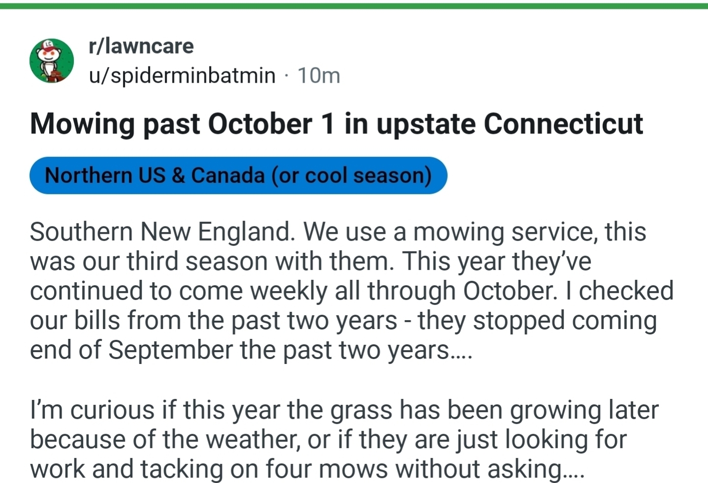
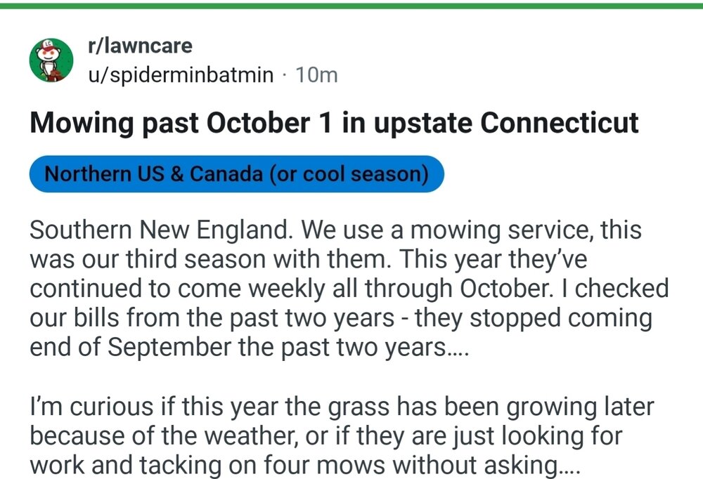
Seems Sus stopping mowing end of September.
-
Preety big brush fire few miles from here. Forest service heli scooping water from Coffee Pond Sent from my SM-S921U using Tapatalk
-
Interesting! My wife and I yesterday said it’s a muted color season around HBG.
-
"Upstate CT"??? LOL
-
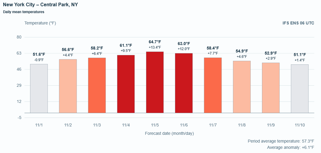
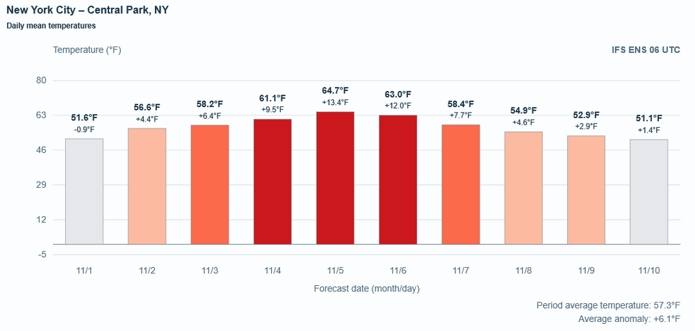
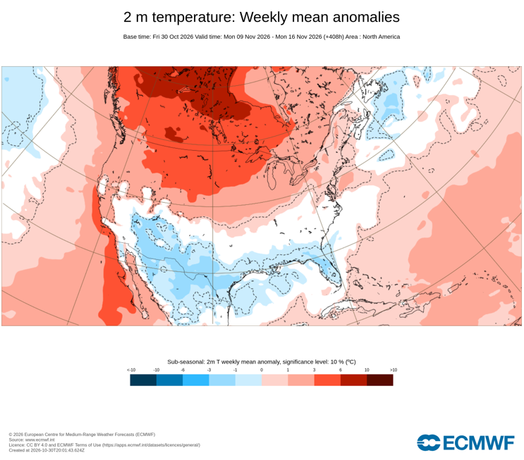
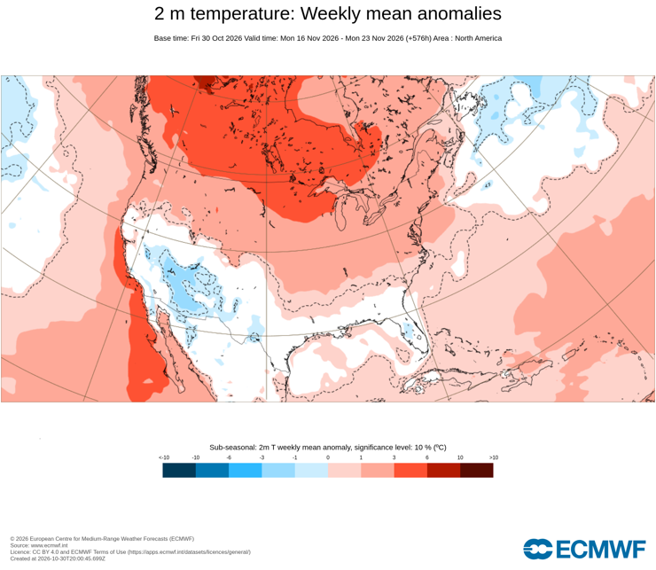
November is poised to get off to a balmy start in the New York City area. However, around November 10th +/- few days it could turn briefly cooler. That shows up on the latest ECMWF ensembles. It is also consistent with the weekly guidance. The biggest uncertainty concerns the forecast weakening/possible split of the polar vortex toward mid-November. However, the ensembles favor a rapid recovery suggesting that the effects could be short-lived. Meanwhile a historically strong El Niño continues to strengthen. It will likely peak in November or possibly December.
-

2026-2027 Record-breaking El Nino
Typhoon Tip replied to Stormchaserchuck1's topic in Weather Forecasting and Discussion
Not directed at you Don, just in general.. I wish the scientific ambit would elect to place a "P" on SSW as a suffix, for/if/when an intrusion of warming into the PV/stratospheric pressure coordinates is proven ( crucially ) to be a downward "P"ropagating event. There is a life cycle to the SSW --> -AO, that requires some 20 to 30 days to complete. Whether this is that, or just an intrusion that quickly disappears ... still remains to be seen. This needs to be factored into this "suspected" intrusion event and I'm not reading anywhere, in or outside this social media ... like that is in the gears of reasoning. First of all, the AO is progged currently at CPC to go ~ -.75 SD over this next week. There is no antecedent SSW/propagating downward phenomenon prior to that occurring. Should this 10 mb warm node and any vortex collapse become resonate ( downward radiating through the vortex) .... your looking at the end of November before any AO mode response - when considering the proven total SSW phenology. I just suspect that SSW is being blurred in the proper usage of why Sudden Stratospheric Warming was originally identified. Since there are intrusion events that don't down well, yeah... technically it's a warming in the stratosphere that is/was rather expedient in how it manifested. But semantically... and really machine wise, if you want an SSW to correlate to winter at mid latitude, it has to go thru 20+ day downward evolution, then the -AO happens. And I still don't see that very convincingly modeled in the GFS. What I do see occurring is both aft of present and continuing in the models, a warmer than normal static 70 to 100 hPa level state. I'm willing to hunch pretty heavily that it's CC related... This looks more like a pan-dimensional aspect than an intrusion - aside from the fact that it's emerging from the bottom up. As well, it is/has vastly predated(s) the canonical 'disruption season'.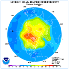
-
2026-2027 Record-breaking El Nino
40/70 Benchmark replied to Stormchaserchuck1's topic in Weather Forecasting and Discussion
I assume this is a typo..... -
 mexican pharmacy online medications or cheapest mexican prescription drugs mexican rx https://maps.google.com.do/url?sa=t&url=https://fronteracaredirect.shop mexican pharmacy prices and https://cyl-sp.com/home.php?mod=space&uid=201848 mexican online pharmacy buy medicine [url=https://54.inspiranius.com/index/d1?diff=0&source=og&campaign=9931&content=&clickid=vphvzfqwlhfhdcgu&aurl=https://fronteracaredirect.shop]mexican online pharmacy buy medicine[/url] purple pharmacy online and [url=http://ussher.org.uk/user/kvbpbcsrpd/?um_action=edit]mexican medicine[/url] cheapest mexican pharmacy online
-
mexican pharmacy online medications or cheapest mexican prescription drugs mexican rx https://maps.google.com.do/url?sa=t&url=https://fronteracaredirect.shop mexican pharmacy prices and https://cyl-sp.com/home.php?mod=space&uid=201848 mexican online pharmacy buy medicine [url=https://54.inspiranius.com/index/d1?diff=0&source=og&campaign=9931&content=&clickid=vphvzfqwlhfhdcgu&aurl=https://fronteracaredirect.shop]mexican online pharmacy buy medicine[/url] purple pharmacy online and [url=http://ussher.org.uk/user/kvbpbcsrpd/?um_action=edit]mexican medicine[/url] cheapest mexican pharmacy online
-
37.5 this morning. Beautiful afternoon
-
Some angry people in Northern CT already complaining about mowing into Mowvember.
-
mexican pharmacy online medications or cheapest mexican prescription drugs mexican rx https://maps.google.com.do/url?sa=t&url=https://fronteracaredirect.shop mexican pharmacy prices and https://cyl-sp.com/home.php?mod=space&uid=201848 mexican online pharmacy buy medicine [url=https://54.inspiranius.com/index/d1?diff=0&source=og&campaign=9931&content=&clickid=vphvzfqwlhfhdcgu&aurl=https://fronteracaredirect.shop]mexican online pharmacy buy medicine[/url] purple pharmacy online and [url=http://ussher.org.uk/user/kvbpbcsrpd/?um_action=edit]mexican medicine[/url] cheapest mexican pharmacy online
-
Grass is still green but not growing. I did my last cut for the season on Monday and it was more for snow prep, I like it a little shorter for winter, than actually growth which wasn't much the last ten days.
-
Yesterday's wind really took down a lot of those colorful leaves. This year's fall foliage was imo the most colorful i had in my area in years.
- Today
-

2026-2027 Record-breaking El Nino
donsutherland1 replied to Stormchaserchuck1's topic in Weather Forecasting and Discussion
I suspect that this is how things will play out. Historic experience with strong El Niño events, flood of Pacific air into North America, seasonal timing of the SSW (anecdotally, it seems that the polar vortex is able to recover more quickly with earlier SSW events, possibly due to the seasonal transition; during mid-winter one is dealing with a more stable regime). Moreover, the El Niño event continues to strengthen. -
I have a few strawberry plants me and my kids potted in the spring and they have flowered again and have berries ripening. And I have been below freezing twice and had frost for a week straight. It's odd.
-
Some stats Looks like Pittsburgh had its sunniest period : Pittsburgh just experienced its "clearest" and sunniest period on record, according to data shared by Weather World PSU in : https://x.com/WeatherMatrix/status/2116156806841893217 ) Record for rainless period: Today is 15 for most some are at 16 or 17 days pending if you had any measurable rain on Oct 16th() NYC — Central Park Rank Days Start Date End Date 1 36 Oct. 9, 1924 Nov. 13, 1924 2 29 Sep. 30, 2024 Oct. 28, 2024 3 28 Sep. 5, 1941 Oct. 2, 1941 4 27 Sep. 10, 1910 Oct. 6, 1910 4 27 Sep. 1, 1884 Sep. 27, 1884 EWR — Newark Liberty International Airport Rank Days Start Date End Date 1 41 Sep. 30, 2024 Nov. 9, 2024 2 26 May 30, 1949 Jun. 24, 1949 3 25 Nov. 6, 1939 Nov. 30, 1939 4 24 Aug. 16, 1995 Sep. 8, 1995 4 24 Jan. 23, 1980 Feb. 15, 1980 Additional 24-day ties occurred in 1963, 1959 and 1942. PHL — Philadelphia International Airport Rank Days Start Date End Date 1 42 Sep. 29, 2024 Nov. 9, 2024 2 29 Oct. 11, 1874 Nov. 8, 1874
-
I have a feeling December could suprise everyone. We are in uncharted territory.
-
Records: Highs: EWR: 83 (2024) NYC: 81 (1946/2024) LGA: 83 (2024) JFK: 78 (2024) Lows: EWR: 29 (1975) NYC: 29 (1925) LGA: 33 (1975) JFK: 30 (1966) Historical: 1846 - Eighty-seven pioneers were trapped by early snows in the Sierra Nevada Mountains that piled five feet deep, with 30 to 40 foot drifts. Just 47 persons survived the "Donner Pass Tragedy". (The Weather Channel) 1884: Brownsville, TX reported 15.71 inches of rain for the month, nearly five times normal. (Ref. AccWeather Weather History) 1887: Weather records have been kept at Charlotte, NC since 1878. The only snow ever to occur there in October happened on this date. (Ref. AccWeather Weather History) 1899: A Caribbean hurricane crossed Cuba then moved north and made landfall at the North Carolina/South Carolina border. The hurricane became extra-tropical in Virginia, then curved across southeast Pennsylvania and moved into New England and the Canadian Maritimes. The highest wind gusts were measured to 84 mph at Cape Henry, VA, 82 mph at the Delaware Breakwater, DE and 60 mph at Norfolk, VA. (Ref. Wilson Weather History) Richmond had 1.71 inches of rain on this date in 1899. (Ref. Richmond Weather Records - KRIC) 1925: Record low October temperature readings were set from northern New England down to the Mid-Atlantic to the Ohio Valley. Record lows included: Van Buren, ME: 1°, Garfield, VT: 2°, Pittsburg, NH: 4°, Houghton Lake, MI: 7, International Falls, MN: 12, Peoria, IL: 14, Rockford, IL: 14, Madison, WI: 16, Alpena, MI: 17, Burlington, VT: 17°, Syracuse, NY: 20°, Flint, MI: 20, South Bend, IN: 20-Tied, Dubuque, IA: 25-Tied, Allentown, PA: 22°, Avoca, PA: 22°, Springfield, IL: 22, Rochester, NY: 23°, Fort Wayne, IN: 23, Indianapolis, IN: 24, Buffalo, NY: 25°, Grand Rapids, MI: 25, Wilmington, DE: 25°-Tied and New York (Central Park), NY: 29°-Tied. (Ref. Wilson Weather History) (Ref. AccWeather Weather History) 1950 - Unseasonably warm weather prevailed in the central U.S. for Halloween. The temperature soared to 83 degrees at Minneapolis MN, their warmest reading of record for so late in the season. Other record highs included: Charlotte, NC: 85°, Raleigh, NC: 85°, Richmond, VA: 85°, Washington, DC: 85°, Chicago, IL: 84°, Rockford, IL: 84°, Greenville-Spartanburg, SC: 84°, Greensboro, NC: 84°, Athens, GA: 84°-Tied, Omaha, NE: 83°, Springfield, MO: 83°, South Bend, IN: 83°, Columbus, OH: 83°, Beckley, WV: 83°, Roanoke, VA: 83°, Cleveland, OH: 82°, Lexington, KY: 82°-Tied, Allentown, PA: 81°, Harrisburg, PA: 81°, Cincinnati, OH: 81°, New York (LaGuardia Airport), NY: 80°, Dayton, OH: 80°, Bristol, TN: 79°, Asheville, NC: 79°, Elkins, WV: 77°-Tied, New York (Central Park), NY: 76°-Tied, Bridgeport, CT: 73° and Buffalo, NY: 72°. (Ref. Wilson Weather History) (The Weather Channel) 1963: The 28-day dry streak came to an end at Philadelphia, PA. The streak still stands as the longest in their history. (Ref. AccWeather Weather History) 1965 - Fort Lauderdale, FL, was deluged with 13.81 inches of rain, which brought their rainfall total for the month of October to an all-time record of 42.43 inches. (30th-31st) (David Ludlum) (The Weather Channel) 1971: Snowstorm with 8 inches in Caribou, MN. (Ref. AccWeather Weather History) 1987 - Halloween was a wet one in the southwestern U.S. Heavy rain in southern California resulted in numerous mudslides. Weather-related auto accidents resulted in three deaths and twenty-five injuries. Mount Wilson CA received 3.14 inches of rain in 24 hours. Yakima WA reported measurable rainfall for the first time since the 18th of July. The 103 day long dry spell was their longest of record. (The National Weather Summary) (Storm Data) 1988 - Twenty-two cities in the northeastern U.S. reported record low temperatures for the date. The low of 19 degrees at Cleveland OH was a record for October, and morning lows of 21 degrees at Allentown PA and Bridgeport CT tied October records. Nine cities in the southwestern U.S. reported record high temperatures for the date, including Phoenix AZ with a reading of 96 degrees. Showers made Halloween a soggy one in the southeastern U.S. (The National Weather Summary) 1989 - Halloween night was a soggy one in New England. Showers in the northeastern U.S. produced more than an inch and a half of rain in six hours at some locations. An invasion of cold arctic air brought an abrupt end to a week of "Indian Summer" type weather in the Great Lakes Region, and brought snow and subzero wind chill readings to the Northern Plains. In Colorado, Alamosa was the cold spot in the nation with a record low of two degrees above zero, and a Halloween night storm brought 3 to 6 inches of snow to the Front Range, and 5 to 10 inches to the nearby foothills. Icy streets around Denver the next morning made for a rather spooky commute. (The National Weather Summary) (Storm Data) 1991: Pueblo CO reported 16.5 inches of snow during the month to set a record for October. (Ref. AccWeather Weather History) 1991: A severe winter storm, dubbed the Great Halloween Mega Storm, struck the upper Midwest. Minnesota bore the brunt of this storm. Blizzard conditions occurred with winds gusting frequently to 40 and 50 mph. By the time it was all over on November 2nd, Duluth recorded 37 inches, Minneapolis 28 inches, International Falls 18 inches and 11.2 inches in 24-hours at Sioux Falls, SD, their earliest heavy snowfall of 6 inches or more and snowiest October on record. For Duluth and Minneapolis, the snow amounts set new all-time records for the greatest amount of snow in a single storm. The storm gave these two cities nearly half of their average seasonal snowfall. 1993: Southern Plains cold wave continues. 43 record lows set. 28 degrees in Corpus Christi Texas was the coldest ever in October or November at that location. Brownsville recorded 35 degrees to also set a monthly record. (Ref. AccWeather Weather History) 1994: A commuter airliner crashed near Roselawn, IL, killing all 68 people on-board. The National Transportation Safety Board concluded that icing on the aircraft's control surfaces led to the crash. The board found that ice on the ailerons disrupted the air flow around them and caused the plane to roll upside down. The crash led to research that has led to more accurate icing forecasts for aviation, leading to safer flying. (Ref. Wilson Weather History) 2000: October is third driest since 1870. The month ended as the third-driest October in Baltimore, and the second driest ever in Washington, since record keeping began. (Washington Weather Records - KDCA) October is normally the driest month in Baltimore, averaging just 2.98 inches of rain. But Baltimore-Washington International Airport has seen only three days of measurable rain since Sept. 26. and two of those days delivered only 0.01 of an inch each. All told, only 0.08 of an inch of rain has fallen at BWI since Sept. 26. That was 32 days ago. The only Octobers that were drier were in 1924, when barely 0.05 of an inch fell and October 1963, when only a trace of rain was detected at the airport. Baltimore's records go back to 1870. Washington, DC, has had just 0.02 inches of rain since Sept. 26. Only October 1963 was drier, with just a trace of rain. Early relief is not likely. October is third driest since 1870. (Source: Baltimore Sun) Richmond, Virginia had the driest October and also the driest of any month on record with only 0.01 inches precipitation. (Ref. Richmond Weather Records) An F2 tornado destroyed the Oconto, NE, community center while 19 children/4 adults were sheltered in the basement. Every building along main street was destroyed/damaged. (Ref. Weather Guide Calendar with Phenomenal Weather Events 2011 Accord Pub. 2010, USA) 2014: Snow began falling early Halloween morning in the northwest suburbs. People in the city saw some flakes. It hasn't snowed on Halloween since 1993, and it was only a trace amount of snow that year. But .10 inches of snow was recorded at O'Hare just before 9 a.m. Friday, marking the first measurable snowfall on Halloween in Chicago history. The average date of the first measurable snowfall in Chicago is Nov. 16. (Ref.NBC Channel 7News CHICAGO(WLS)
-
If JB was worried about a blown forecast, he shouldn't limit it to just December as the cause. Lol