All Activity
- Past hour
-

January 2026 regional war/obs/disco thread
40/70 Benchmark replied to Baroclinic Zone's topic in New England
Cold, icy and windy has characterized this winter so far. -

January 2026 regional war/obs/disco thread
CoastalWx replied to Baroclinic Zone's topic in New England
Yeah icy again this morning. Black ice of yore. -

Occasional Thoughts on Climate Change
Typhoon Tip replied to donsutherland1's topic in Climate Change
https://phys.org/news/2026-01-ocean-temperatures-high.html -
January 2026 regional war/obs/disco thread
40/70 Benchmark replied to Baroclinic Zone's topic in New England
There will be something of significance this month...we aren't making it to February in single-digits. -

Winter 2025-26 Medium/Long Range Discussion
Cary67 replied to michsnowfreak's topic in Lakes/Ohio Valley
Some areas over 3" downtown. ORD at 1.9" -
January 2026 regional war/obs/disco thread
40/70 Benchmark replied to Baroclinic Zone's topic in New England
I like that period better......beyond mid-month. -
January 2026 regional war/obs/disco thread
40/70 Benchmark replied to Baroclinic Zone's topic in New England
Well said. I think CC is playing a part in the absence of winter weather over the past several years, but it's not "the new norm"....it's just accentuating and protracting these oscillations. Just my take...I think it also played a role in the snow-blitz of 2015. -
Beautiful color thos morning. Sent from my SM-G998U using Tapatalk


-

Winter 2025-26 Medium/Long Range Discussion
A-L-E-K replied to michsnowfreak's topic in Lakes/Ohio Valley
yeah that was cool -
this is the final PNS from BOX on Feb 13th


-

January 2026 regional war/obs/disco thread
Damage In Tolland replied to Baroclinic Zone's topic in New England
The ice this winter has been tough. Roads everyday this week just ice everywhere -

January 2026 Medium/Long Range Discussion
RevWarReenactor replied to snowfan's topic in Mid Atlantic
You can't seriously be taking anything the GFS says at hr 233 as gospel can you? Last week Chicago went from a Blizzard at hour 141 to a rainstorm one run later. -
I'll have to try to dig out my old notes wherever the hell they are lol. If I'm remembering correctly East Windsor had a hair more than Simsbury although maybe I'm of the information backwards. I know the Simsbury measurement is correct
-

Central PA Winter 25/26 Discussion and Obs
WmsptWx replied to MAG5035's topic in Upstate New York/Pennsylvania
Oh look... Giant ass hole right where it always seems to be. -
Some of their maps are LOL

-
Winter 2025-26 Medium/Long Range Discussion
Cary67 replied to michsnowfreak's topic in Lakes/Ohio Valley
Met your precip quota for the rest of the winter last night. -
Sea level rise is accelerating along the Gulf and Atlantic coasts. Here are Savannah and Cape May for instance. Data available at link below. https://psmsl.org/data/obtaining/stations/395.php Savannah Cape May


-
January 2026 regional war/obs/disco thread
CoastalWx replied to Baroclinic Zone's topic in New England
It’s just good to see that the deterministic models finally trying to show something out of this pattern. But yeah, I’m with Will, if we can sneak in something a week from now that would be a pretty awesome bonus. -
January 2026 regional war/obs/disco thread
CoastalWx replied to Baroclinic Zone's topic in New England
yeah, it’s fairly mild until like Thursday night lol. He can enjoy jogging on the bare ground again. -
.5" at the stake but there's large patches of grass visible. I'm positive the stake will be 0" before the end of the day.
-
34 in East Windsor? Every town surrounding it had reports of 22-25" including BDL. I didn't see anything like that looking through all the available data. that map includes every possible report i could find from cocorahs, COOP and the PNS which is what i go off of and i think is far more realistic and accurate than the NESIS map which has none of CT above 30" which is ridiculous.

-

January 2026 regional war/obs/disco thread
ORH_wxman replied to Baroclinic Zone's topic in New England
MLK weekend itself looks like there is potential. -

January 2026 regional war/obs/disco thread
Sey-Mour Snow replied to Baroclinic Zone's topic in New England
Solid look for overrunning still .. very cold in canada especially EPS -
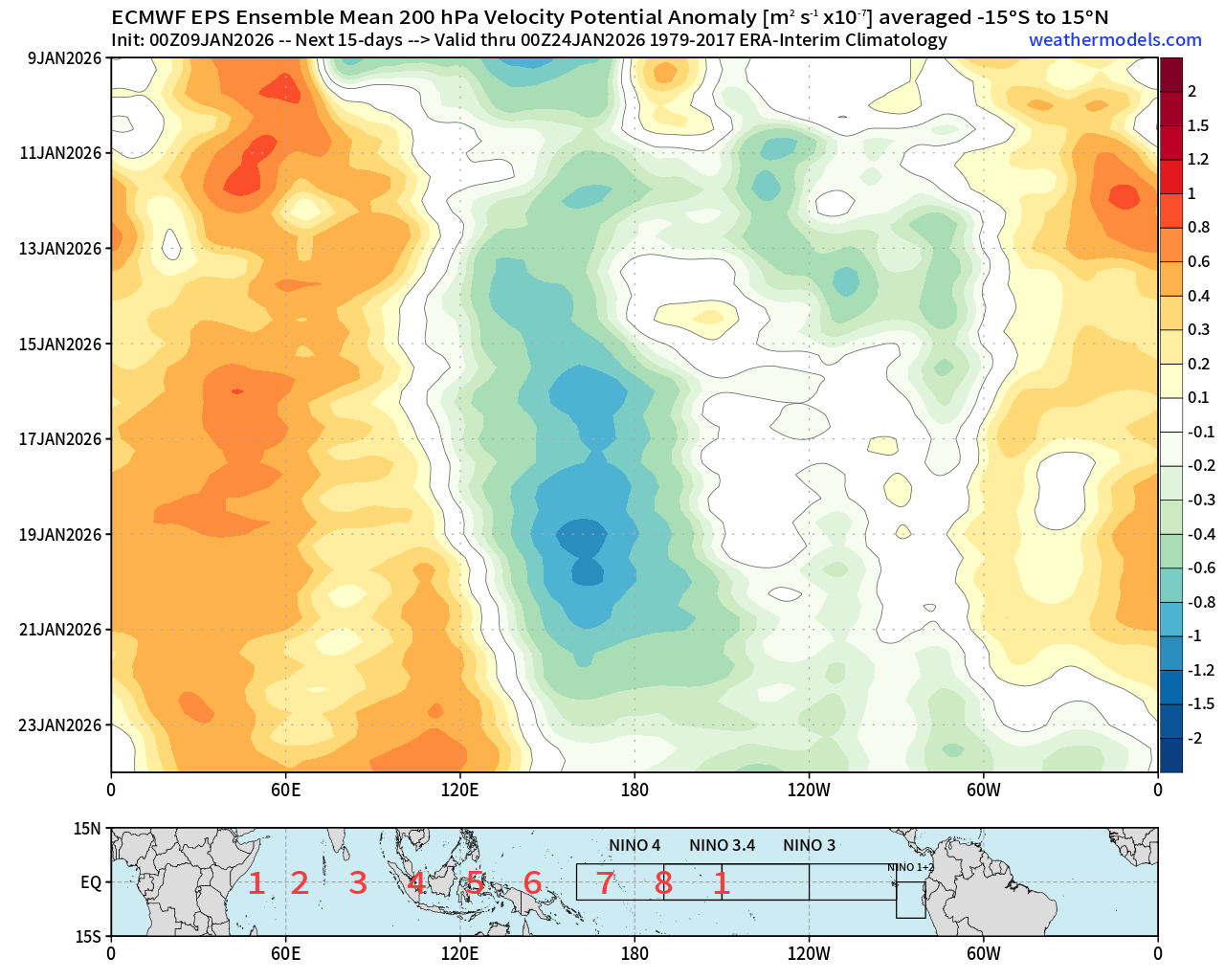
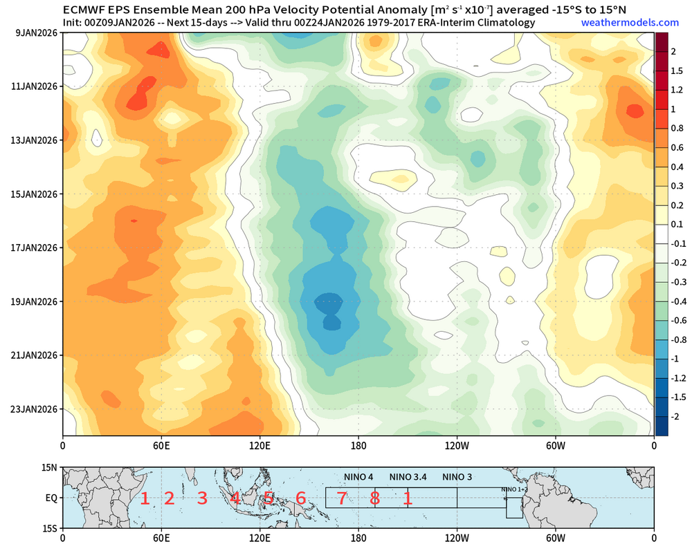
Now, it does actually appear that the MJO is looking to get active once again. Initiating in the west Pacific as per the possibility mentioned by the CPC. This is a pretty good look at a phase 6 then 7 firing off on the EPS. GEFS doesn't disagree either. We may have another attempt at a phase 8 pass on our hands beyond this. Perhaps a better chance this time with the warm pool a bit further east this time. To me, the key to pulling that off successfully is to see the strong subsidence push fully into 120E. Along with the propagation of convection into the western hemisphere. Which guidance is hinting at may actually happen towards the end of these runs lately. That's promising IMHO. That did not occur last time.
-
http://www.ocean.iap.ac.cn/pages/dataService/dataService.html?languageType=en&navAnchor=dataService