All Activity
- Past hour
-
Snip of the 434 LWX AFD... Forecast details: Precipitation is expected to break out from west to east across the region late tonight into early tomorrow morning as large scale ascent ahead of the approaching upper trough gradually overspreads the area. Precipitation should begin as a mixture of light rain and snow for most, with all snow above around 1500 feet. Surface temperatures will initially be in the mid to upper 30s at lower elevations, and should hold in the mid 30s through mid-afternoon. As a result, much of the region will experience several hours of mixed rain and snow that won`t accumulate and will largely be unimpactful other than making the roads wet. However, snow will accumulate across the higher elevations above 1500 feet throughout the day. As we move into the late afternoon and evening, a combination of factors will enable temperatures to start to fall. First, we will start to lose solar insolation as the sun angle drops and the sun eventually sets. Second, low-level cold advection will increase as the upper trough approaches from the west and the coastal low intensifies offshore, drawing colder air into the region within northerly flow. Finally, increasing large scale lift ahead of the upper trough and to northwest of the developing coastal will act to dynamically cool the column. This will result in a gradual changeover to all snow from higher to lower elevations through the late afternoon and evening hours as temperatures fall from the middle to lower 30s. The heaviest precipitation locally is expected Sunday evening through the first half of Sunday night as the coastal low tracks off the Delmarva and the upper axis trough moves overhead. Two locally enhanced areas of precipitation are expected within a much broader precipitation shield that will encompass most of the forecast area. The first area of enhanced snowfall rates will be close to Chesapeake Bay, where mid- level frontogenetic forcing to northwest of the coastal low will be strongest. There is a bit of uncertainty about how just far west this area of heavier snow gets, but most solutions show it only impacting the counties immediately adjacent to Chesapeake Bay in our forecast area (St. Mary`s northward through Cecil). Snowfall rates could approach an inch per hour at times in this area between roughly 6 PM and 2 AM. The second area of enhanced snowfall rates will be along an inverted trough axis (sometimes referred to as a Norlun trough) that will extend north to south through north-central portions of the forecast area. Dynamically, this will occur along a low- level trough axis (in the 900-700 hPa layer) where northeasterly winds in response to the developing coastal low offshore converge with northwesterly winds advancing beneath the upper trough. Model guidance is in very good agreement that such a feature will occur, but there is still some uncertainty with respect to the positioning. Such features typically are very, very narrow in width (likely only 10-20 miles from west to east), and are notorious for producing very heavy snowfall rates. Most guidance shows hourly QPF values of around 0.1-0.2 inches, which would translate to 1-2 inches per hour of snow. This feature will likely be either stationary or very slow moving over several hours tomorrow evening into early tomorrow night. A narrow band of 6-12 inches could occur as a result. Due to position uncertainty, we spread this enhancement in precipitation out over a slightly wider location than will likely occur in reality. American model guidance (GFS, NAM, HRRR, 3 km NAM, WRF-ARW, FV3, WRF-NSSL) have this feature occurring roughly from Hancock, MD southward through Winchester toward Front Royal, while most other guidance (Euro, Canadian, ICON, most EPS members) have it occurring from near Hagerstown southward into Loudoun County. Our current forecast hedges the placement slightly more toward the eastern solution (Hagerstown to Loudoun County), but has an enhancement over that broader region. This is also why the Winter Storm Warning extends southward and wraps around the DC Metro area. The immediate DC Metro will likely fall within a relative min between these two areas of precipitation enhancement, but will still experience several hours of accumulating snow tomorrow evening into tomorrow night. Another localized minimum will be between the inverted trough and the Allegheny Front. Very little in the way of snow may end up falling in the shadow of the mountains just to the east of the Allegheny Front and also in the Central Shenandoah Valley. Across the entire forecast area, snow totals will be heavily elevation and snow rate dependent. With such marginal temperatures in place, a lot of the snow will be lost to melting at lower elevations with surface temperatures above freezing, while higher elevations have lower temperatures and accumulate more efficiently. The aforementioned heavier snowfall rate areas (closer to the low and near the inverted trough) will help to drive dynamic cooling through strong lifting in the column, thereby bringing cooler temperatures down to lower elevations, and making snowfall accumulate more efficiently. In terms of specific accumulation amounts, a general 2-4 inches is expected in the DC Metro, although there could be locally lower totals at the lowest elevations if warmer temperatures and lighter precipitation rates verify. 4-6 inches is expected along the Bay shore from St. Mary`s northward through Baltimore City, with higher totals of 6-12" from Carroll eastward toward Cecil. Higher totals of 8-16 inches are expected in the Catoctins, where snow will accumulate more efficiently throughout the event. Snow will also accumulate efficiently southward along the Blue Ridge, where a general 6-10 inches of snow is expected. To the west of the Blue Ridge, snow totals will be heavily elevation dependent, with 3-6 inches expected at higher elevations between the Allegheny Front and Blue Ridge, while lower elevations in the Central Shenandoah Valley and Potomac Highlands see little in the way of accumulation. A general 1-3 inches is expected at lower elevations along the I-70 corridor to the west of the Blue Ridge, with the exception of near Hagerstown, where they could receive significantly more snow under the inverted trough. For now, that inverted trough area which extends southward from near Hagerstown into Frederick and Loudoun is forecast to receive around 3-6", but as mentioned before, the gradient will likely be tighter than depicted, and the max there will likely be between 6 and 12 inches. In the Alleghenies Winter Storm Warnings are in effect. Snow will linger much longer there through the day Monday within upslope flow behind the departing low. Snowfall accumulations there are expected to reach 6-12 inches by Monday evening. Elsewhere, snow should wind down late tomorrow night through mid-morning Monday.
-
seen it here in nj too....2/6/10, 12/09, feb 2013, jan 2015, mar 2017.....and the winner of all time, march 2011....even march 93 was a bit of a letdown....
-
GFS to 12
-

“Cory’s in NYC! Let’s HECS!” Feb. 22-24 Disco
ineedsnow replied to TheSnowman's topic in New England
that's so awesome -
Question for mets and model gurus. When data gets fed into a model (i.e., GFS), I understand in the satellite era how it's pretty easy to get temp data and precip/humidity. But how do they capture atmospheric dynamics like the various vortices? Clearly just utilizing weather station data and weather balloons wouldn't be near a high enough resolution to initialize a model accurately. Do they do something fancy with satellites and refraction to measure Eddy currents in the atmosphere?
-
If this pans out, Heisy won’t have far to go to chase.
-
do you think we will have thundersnow tomorrow evening?
-
It’s the ICON. Model hasn’t gotten a clue for days
-

“Cory’s in NYC! Let’s HECS!” Feb. 22-24 Disco
weathafella replied to TheSnowman's topic in New England
Just past midnight tonight. Had to go through ATL with a 2 hour layover. NAM is amazing and 3k even better! -

The February 22-23 Late Season Miracle: JV Disco/Banter Thread
stormy replied to bncho's topic in Mid Atlantic
Can the energy over Indiana phase with se energy????? The big question and placement of the coastal...... This will be an historical event, for many reasons. -
So Mt. Holly updated their CWA map, but not the better map showing neighboring areas - anyone seen that yet (not on FB/Twitter/NWS pages)...
-
“Cory’s in NYC! Let’s HECS!” Feb. 22-24 Disco
ineedsnow replied to TheSnowman's topic in New England
no just winter storm watches -
the 96 storm to me is still the best for the huge area wide totals i remember watching the weather channel in the afternoon and dave schwartz mentioned laguardia had 4 inches of snow in the past hour..
-
I don't think we'll know for sure until we're in it.
-
Lets hope this is a storm that trends better and better up until go time unlike the last one that got further and further suppressed south.
-

Blizzard of 2026 Storm Thread/OBS
bringmesnow1 replied to Mikeymac5306's topic in Philadelphia Region
Lmaooo I'll suffer through it bro -
Shameless bump. I ran an analysis simulation w/WRF for the 78' blizzard that evaluated well
-

“Cory’s in NYC! Let’s HECS!” Feb. 22-24 Disco
40/70 Benchmark replied to TheSnowman's topic in New England
Often guidance n ever really catches up to the later maturation. -

“Cory’s in NYC! Let’s HECS!” Feb. 22-24 Disco
Henry's Weather replied to TheSnowman's topic in New England
Blizzard watches are still a thing? -
This is very safe and an accurate forecast. They should leave it alone and let it rock
-

“Cory’s in NYC! Let’s HECS!” Feb. 22-24 Disco
Baroclinic Zone replied to TheSnowman's topic in New England
Oh hell yeah!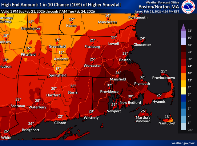
-
Yep, the Boxer Day storm for most of Long Island was an experience of looking at the radar and seeing the mega band over Jersey just sit and dump snow as we experienced light to moderate... 24+ in those parts while we got 12-15"... Those are hard to sit through ... Sent from my motorola edge 2024 using Tapatalk
-

Pittsburgh/Western PA WINTER ‘25/‘26
EVLINC64 replied to Burghblizz's topic in Upstate New York/Pennsylvania
I had 93 as well, but I enjoy a heavy snowfall more without the high winds. 94 is still my all time favorite as I lived in Westmoreland County at the time and ended up with 27 inches. Moderate to heavy snow most of the day. Was a senior in High School and was off school all week. Good times. PFFFFFT walked to school in winter of 77-78 & some asshat stole my winter coat & my Dad was between jobs as he always called it ! Not Unemployed & told me You aren't getting a new coat had snow on ground all winter & the Yough Had a massive incejame in Sutersville & Boston Pa. & the river froze so solid I walked across it to get to school quicker -

“Cory’s in NYC! Let’s HECS!” Feb. 22-24 Disco
ORH_wxman replied to TheSnowman's topic in New England
Reminds me of the hesitancy prior to October 2011 storm. That one ramped up close too and it had the added stigma of being so early which caused a lot of procrastination on the warnings. This is nuts on the models…people should be warned for this one. -
The second this storm ends he'll be back in the La Nina thread. That or forecasting a Super El Nino next year. Book it


