All Activity
- Past hour
-
-
I keep seeing 2013-14 as an analog. Saw a story a couple days ago that said the North Pacific especially behaving very similarly.
-
jumping the gun a bit to early..
-
Ai models won big with Erin track days before everyone jumped on board... . Icon took a big win imo on that storm as well, which is crazy to say lol
-

Potential Tropical Cyclone Nine
Coach McGuirk replied to WxWatcher007's topic in Tropical Headquarters
What's the A.I. modelz? -

September 2025 OBS-Discussion centered NYC subforum
Cfa replied to wdrag's topic in New York City Metro
Made it up to 87 here, I wish this happened tomorrow (Saturday) instead. This year has really been a snoozefest on all fronts, the only exception being the 100+ degree heat in June and July. -
Even with this half scan, Humberto is an absolute beast.
-
AI ftw?
-

Potential Tropical Cyclone Nine
NC US Geological Survice replied to WxWatcher007's topic in Tropical Headquarters
Doesn't have its act together. I'm buying all the shares of OTS. All hail the A.I. modelz. (AND Icon/Ukie) Edit: i know there're a lot of solutions on the table. Just following the evening hype train right now. Til tmrw folks. -

September 2025 OBS-Discussion centered NYC subforum
anthonymm replied to wdrag's topic in New York City Metro
Wasted the cold air in august and first half of September. I guess it made what is usually the worst part of summer more tolerable but now we have typical late august temps happening in late september-early oct. Fall's taking a break for the foreseeable future. -
September 2025 OBS-Discussion centered NYC subforum
anthonymm replied to wdrag's topic in New York City Metro
What is causing the ridiculously consistent +8 F temps above normal literally every single day? Is it just the EPO? It's a january 2023 torch-like pattern. -

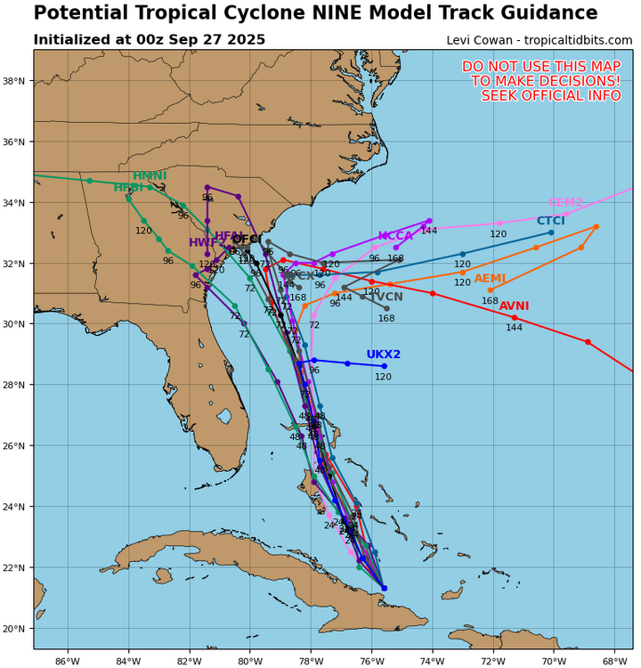
Potential Tropical Cyclone Nine
Wannabehippie replied to WxWatcher007's topic in Tropical Headquarters
https://www.tropicaltidbits.com/recon/recon_NOAA2-0909A-PTC09.png -
Huge win for all of us if the trends this evening are correct. Seems like the slower organization of PTC9 and the rapid ramp up for Humberto are starting to get sniffed out. Hopefully it feels that influence more than the ULL. I’ll never forget everyone thinking the ULL last year would tug Helene from Tallahassee to Chattanooga and we saw that model bias get exposed in an unfortunate manner but maybe this time “fortunately” is the word??
-
High of 94 after a low of 72. Felt like summer once again.
- Today
-

2025-2026 ENSO
Daniel Boone replied to 40/70 Benchmark's topic in Weather Forecasting and Discussion
Yeah, it's basically if the end is above in aerial coverage is what it boils down to. -

The "is it ever going to rain again?" discussion.
Eskimo Joe replied to JenkinsJinkies's topic in Mid Atlantic
Mid January...get a cold front with a juiced wave along it that signals a flip to a workable winter pattern. -
Yeah, 2010-11 was an oddity. Every Forecast was for a mild to very mild Winter due to the moderate to strong Nina. Blocking was the big surprise and culprit for the non characteristic Nina Pattern. Same can be said for 95-96, although it was a weak Nina.
-
Potential Tropical Cyclone Nine
Coach McGuirk replied to WxWatcher007's topic in Tropical Headquarters
That could be true too. Nobody knows. -
Potential Tropical Cyclone Nine
Coach McGuirk replied to WxWatcher007's topic in Tropical Headquarters
I said it could be the next Charlie. -
0z hurricane models. More showing the stall and turn east motion now.
-
This maybe a big sike storm.......
-
Potential Tropical Cyclone Nine
NC US Geological Survice replied to WxWatcher007's topic in Tropical Headquarters
I've been telling people at work, "This could be South Carolina's Florence". Do you think that will verify? -
Potential Tropical Cyclone Nine
Coach McGuirk replied to WxWatcher007's topic in Tropical Headquarters
NWS put up a cone for potential 9 nhc.noaa.gov/refresh/graphics_at4+shtml/262347.shtml?cone#contents -
Hiked Red Hill in Moultonborough this afternoon. Easy hike with good views of Winnipauskee, Squam and Southern Whites. Tomorrow plan is to hike Willard in Crawford Notch. Swam for 20 min in lake in the morning - still pretty comfortable. You can tell the foliage is suffering from drought. Very, very dry.
-
So many objectives to play with this winter.I keep seeing social media seemingly saying this is a slam dunk of 2010-2011,why? I mean you do have the early Siberian snowfall going into Oct which is a plus,BUT at the same time in 2010,had seemingly a strong westerly +QBO,in which would keep possibly the PV strong its what we seen last winter In California which is even more unusual during a Nina had record rainfall in Dec of 2010.Even the -NAO,wemt on record of being the strongest ever recorded since 1825 ?Not sure how records were recorded back then,im not that old..lol


