All Activity
- Past hour
-
5.21" for the month o June so far following 7.62" for May. 12.83" since May 1st.
-
 a excessive heat warning is when temps and humidity are basically guaranteed to reach a certain criteria while a extreme watch is not as confident the criteria will be met..
 -
Yep, I'll have at least a 'T' to report, light rain falling. ONE shower on radar, right over me ATM. Temp down to 74.3/59.0.
-
so it's made it to 81 F here same next door at KFIT.. It's a weird combination getting these canopy leaner wind gusts at that warm of a temperature. ...just anecdotally.
-
Good friend lives out that way. Just sent me this about an hour ago. I love the West.

-
Same page ... This has evolution room, tho. It's really almost ideal. So we'll see, but for now. If it's 98/72 ... it's not going to make any difference if it's 101/72 save posterity perhaps. Also, many times I've seen big heat, for 3 hours in the afternoon the 72 DPs slip to 66ies while the temperatures are at apex.
-
LOL, clouds have moved in, and it looks like a shower could fall any minute, dropped temp to 77.6/58.5. High was about 30 minutes ago at 81.1. Although warm, I'm definitely liking the lower dew points!
-
Enjoy! One of my favorite places. Doesn't look like you'll get a thunderstorm today. That's a rarity.
-

Occasional Thoughts on Climate Change
Typhoon Tip replied to donsutherland1's topic in Climate Change
no shit ( bold ) I've started bringing this observation up about 15+ years ago actually ... long before it even showed up in papers, that the HC was appearing to be enlarged(ing). I have been relating it to winter gradient steepening and the observed increase in basal geostrophic wind velocities - also the jet cores them selves have quickened. Lot of air-land speed record on west --> east flying commercial air craft over the Pac and Atlantic flight routes in the last 20 years. Anyway, it's effecting storm morphology... and precipitation distribution as well as frequency in the winter. But the cloud aspect ... yeah that's interesting too. -

Occasional Thoughts on Climate Change
LibertyBell replied to donsutherland1's topic in Climate Change
I'm thinking cloud cover is actually increasing in the northeast though, just going by how much wetter our climate has been getting. -
Imagine this forecast on the Summer Solstice... Glacier National Park. We can't even get that in January. Also, yes it is at elevation, but they are going to see snow levels down to like 5,000ft. It's not *that* high up (this point and click is like 6,000ft). Would be like Mount Washington getting plastered on the solstice. Saturday... Snow. The snow could be heavy at times. High near 31. West southwest wind 15 to 18 mph, with gusts as high as 25 mph. Chance of precipitation is 100%. New snow accumulation of 14 to 20 inches possible. Saturday Night... Snow. The snow could be heavy at times. Low around 28. West wind 11 to 14 mph becoming north northwest after midnight. Winds could gust as high as 20 mph. Chance of precipitation is 100%. New snow accumulation of 4 to 8 inches possible.
-
 https://www.weather.gov/news/250310-heat-hazard NWS is renaming its Heat Watch and Heat Warning products to improve messaging. On March 4, 2025, the NWS will implement the following changes: Excessive Heat Watches will be renamed to Extreme Heat Watches. Excessive Heat Warnings will be renamed to Extreme Heat Warnings.
 -
If dew points are overdone, that could feasible let the temps rise a little higher, though I’d still say it tops at 94 max.
-
Not sure…there’s a seabreeze threat Monday, but that shouldn’t affect the interior much. I’m still on the 97-99 with 70s dews train unless I see more widespread 850s around 24C. MEX has been consistently 95-98 in the hot spots Tue. I want to see something more exotic aloft. I’ve seen these 2m shenanigans before.
-
Yeah me too in spots. Can never get them all up . It’s infuriating
-
DTW is located in Romulus, MI. Areas near the airport range from suburban to even semi-rural. Though I currently work from home, from 2015-2021 I had a job where my commute involved passing the airport daily. I became WELL versed in how the temps work (I would pass just south of the airport and then get on the freeway which would drive right past then north of the airport). Temps just south of the airport are an Ann Arbor like bowl of extreme radiational cooling. Talking a quarter mile south of where the airport ends (intersection of Eureka & Middlebelt Rd). I saw this on a daily basis, often passing by at 730am, and the most extreme example I saw was on Feb 20, 2015 when my car read -22F at this spot but the official DTW low was -13F. For whatever reason, the temp always reads lower on the south side of the airport than the north side (where ASOS is). The temps at DTW would consistently come up on the high end of what was reported nearby, but certainly within range. UHI is certainly a factor in big cities, but I feel its more of an "airport heat island effect" at many of the big airports. DTW has grown into a huge airport with numerous runway additions and expansions, the most recent being 2019-20. Even though the ASOS is in a well protected area, theres almost certainly a slight impact from all the nearby concrete runways, especially since the more rural and wooded areas less than a mile outside the airport property run slightly cooler 24/7. I dont feel its a major issue as long as the NWS keeps the thermometer properly calibrated, nor do I feel they should be taking temps in the microclimate of cold readings just south of the airport (as thats not representative). I simply want temps to be representative of what the nearby area is, and with most major sites being at airports its just how it goes. Snow is measured just off site at a park area...would be interesting if there was a thermometer there to compare. Once we get away from DTW to the north and west, there are big elevation difference and some more alternating of bustling areas mixed with rural mixing bowls of raditaional cooling. And then to the northeast is a marine influence. So there are so many variables at play. As long as readings are accurate, thats all I ask for. For instance, with this heat coming, id rather set a record high of 100F with dews in the 60s rather than have it be 93 with a dew of 75. But mother nature makes the call.
-
I've turned a few on to those up here and they love them.
- Today
-

Central PA Summer 2025
Mount Joy Snowman replied to Voyager's topic in Upstate New York/Pennsylvania
Haha tell me about it. Normally we wouldn’t go out on a day like that but we had some friends in town from Alaska who really wanted to go on the boat. What’s nice about that long stretch of river is if you have RadarScope and a weather nerd on board you can pretty easily outrun any storms. But generally speaking, we wouldn’t typically be messing around in such conditions. -
Euro's been having increased run to run variability on details with this week. still, the ens are about at the ceiling for the means. I'm wondering if this doesn't have an extra special sauce with it and the models might or might not even see it - Oper Euro looks lagged/too cool on Monday - may be a mixing issue
-
 Upton issued Extreme Heat Watch issued for most of the area, eastern Suffolk is left out. Is that different for an Excessive Heat Watch/Warning? Or did they just change the terminology? NWS has 100 forecasted for Mon and Tues. At least point and click in the Bx, a lot of Queens
 -
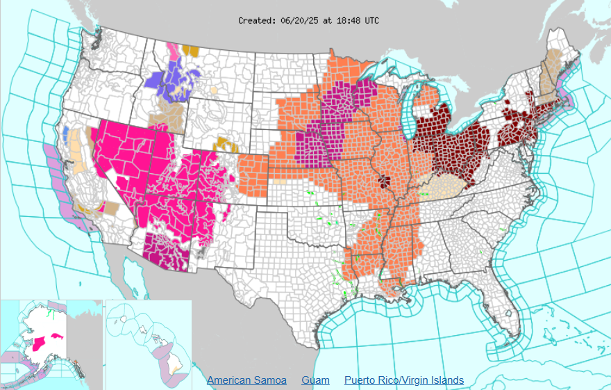
All these advisories for heat and here you have winter advisories in Montana and Idaho
-
-
 Tiko joined the community
 -
Still out but they say somewhere between 4-11 it will be restored. Kemp Mill and Takoma Park got hit really hard
-
https://nutwizard.com
-
MCS exiting Maine is classic backdoor scenario. Heat in jeopardy?


