All Activity
- Past hour
-
For 4 months at least... Sent from my SM-S156V using Tapatalk
-
My call that the snowfall peaked in 17-18 from Philly to Boston and we were at the beginning of a snowfall decline is based on 60 years of snowfall data. I first raised this possibility back around the 2020 winter after only 2 years. I can remember getting plenty of pushback when I raised this possibility just after 2 seasons. But it’s a bit like that old game show Name That Tune. I only needed a few notes to recognize the pattern. In the following years we got more data to confirm my idea. When there was a much colder climate from the early 1960s to the early 1990s, there wasn’t an all or nothing snowfall pattern. Most of the seasons were in a narrow range focused near the long term average mid-range. There were few seasons with very high or very low snowfall. This all began to change in 93-94 as nearly all our snowfall seasons were well below or well below with almost none in the mid range which was a staple of our colder climate. We were cold enough back then to have a bunch of small to moderate events in a season without a KU NESIS storm to reach average. In contrast, none of the seasons since 93-94 reached average or above without some NESIS event contributing to a the seasonal snowfall total. So as we warmed our snowfall became all or nothing. The record 2010s featured mostly all or well above normal seasons. This period indeed was warming while the heavy snowfall was occurring. But even in the warmer winters the snowstorm tracks were still cold. As the Northern Stream of the Pacific Jet was weaker and didn’t disrupt benchmark storm track formations. These days the winter storm tracks have significantly warmed with the storm tracks shifting through the Great Lakes. This lead to an average temperature of 41° degrees this past winter in the I-95 corridor in the days the precipitation over .25 fell. so it negated the overall 34.8° colder average. The dominant storm tracks since the increase of the Northern Stream of the Pacific Jet speeds in 18-19 have been Great Lakes cutter, I-95 , I-78, I-80, and I-84 huggers, and suppressed Southern Stream storms. This makes it very difficult to get to average to above average snowfall. This is why the last 7 years have seen snowfal amounts near all-time lows for a 7 year interval. So we had to rely completely on one type of storm track to reach average to above average snowfall over the past 30 years. But having to rely exclusively on the benchmark storm track in a warming climate has pitfalls. Before 93-94 we would regularly have snowy seasons with hugger and weaker coastal storm tracks since it was still cold enough with those tracks to reach average. These days this type of storm tracks has become much warmer with mostly rain. There was a wider number of ways to get to average when it was colder. The 2010s featured a record number of benchmark storm tracks. This level of benchmark snowstorms was somewhere in the range of a 50 to perhaps 100 year event. So it’s unlikely that amount of benchmark tracks will repeat anytime soon. So we are left with a few scenarios going forward over the next 7 seasons and beyond. One is just a continuation of the last 7 years with well below average snowfall continuing. Another possibility is that we could see a bit of an uptick in benchmark tracks and some improvement over the past 7 seasons. Though any increase would probably come in well below the 2010s levels. My guess is that this would be transient before a lower snowfall regime returns in the 2030s and beyond. The obvious caveat would be some time of super volcanic or cosmic event which would completely shift the climate in a sudden and dramatic way. Absent something like this, increasing emissions will continue to reduce our snowfall over time.
-
Man summer is here. Feels good.
-
I think he was drunk because we were warm sectored all day.
-
Sort range guidance says what rain today. We get a line of scattered showers tonight and that's it for the weekend lol. The drought ain't going anywhere this week.
-
High end of my NWS forecast gives me over 3 inches of rain by Monday night.
-
You playing Schedule 1 with that kind of logic? Sent from my SM-S156V using Tapatalk
-
Idk Hippy... I hit 5 feet with a QPF deficit and feel really content, can't imagine how much we would get with the opposite scenario where our stretch of the valley gets a winter bullseye in this fast flow world Sent from my SM-S156V using Tapatalk
-
This all feels familiar
-
Late next week looks warm and sunny with 70’s right into Mothers Day weekend. Maybe 60’s Friday
- Today
-
...Parts of the East... The greatest relative severe threat within the broad prefrontal region across the East is currently expected from the Carolina Piedmont into parts of the Mid Atlantic and southern New England, where somewhat stronger diurnal heating/destabilization is currently expected. A belt of moderate midlevel southwesterly flow in advance of the slow-moving mid/upper trough will provide sufficient deep-layer shear for some storm organization within a moderately buoyant environment. Organized cells/clusters may develop during the afternoon from the northern Mid Atlantic into southern New England, as a frontal wave and modestly enhanced low-level jet move northeastward across the region. These storms will pose a threat of damaging winds and isolated hail, and perhaps some localized tornado potential.
-
late season flakes for some next week?
-
.gif.a8d0e31513d53ce441fb0ba676044e4d.gif)
-
Hazardous Weather Outlook National Weather Service State College PA 344 AM EDT Sat May 3 2025 PAZ035-036-052-053-056>059-063>066-040745- Fulton-Franklin-Northumberland-Columbia-Perry-Dauphin-Schuylkill- Lebanon-Cumberland-Adams-York-Lancaster- 344 AM EDT Sat May 3 2025 This Hazardous Weather Outlook is for central Pennsylvania. .DAY ONE...Today and tonight. Scattered severe thunderstorms with damaging winds 60 mph or greater and large hail exceeding 1 inch in diameter are possible this afternoon and evening. An isolated weak, short-lived tornado is also possible. Rainfall of 0.5 to 1.0 inch is expected in many areas today, with locally higher amounts possible in places that receive more than one thunderstorm. .DAYS TWO THROUGH SEVEN...Sunday through Friday. Additional, significant, multi-day rainfall totals of 1 to 2 inches with locally higher amounts are forecast for the Sunday through Tuesday period. The long duration rainfall will be initially beneficial, but repeated rounds of heavy rain could produce localized flooding particularly in urban and poor drainage areas. .SPOTTER INFORMATION STATEMENT... Spotters are encouraged to report significant hazardous weather
-
Euro showing storms entering the area early afternoon and then multiple guidance showing storms as we head into the late evening. For tomorrow, it appears there’s a chance the afternoon is more dry than wet so might be able to salvage some time outdoors.
-
.thumb.jpg.6a4895b2a43f87359e4e7d04a6fa0d14.jpg)
Central PA Spring 2025
Yardstickgozinya replied to canderson's topic in Upstate New York/Pennsylvania
I think I see some drought busting possibility down stream on the radar this morning . -
Looks like Saturday is mostly dry here in 21057. Just like all the others. As we get closer it dries up
-
Central PA Spring 2025
Yardstickgozinya replied to canderson's topic in Upstate New York/Pennsylvania
Today https://www.spc.noaa.gov/products/outlook/day1otlk.html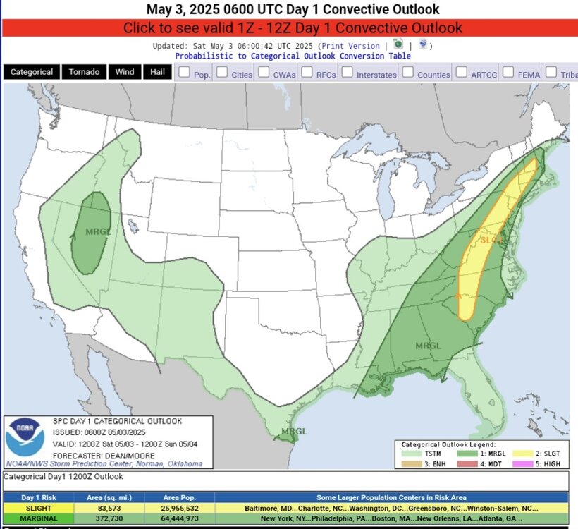
-
While someone someday probably in the not too distant yearly future is snowed in for weeks with feet and feet of snow in the zone of suck. Can't have it all.
-
Ineed was posting daily rainfall maps now we have spider talk, does it mean the heaviest rains the next few days have shifted west?
-
Yep, weekend's gonna suck for sure.
-
this is neat https://www.flydenver.com/press-release/den-celebrates-inaugural-flight-of-the-airbus-a380-by-lufthansa-german-airlines/
-
Marine layer! Cape cod is the king of that. It drives me nuts every year. Fog bank drizzle and 10-20 degrees cooler Until may or June depending on the pattern.
-
Had a couple of decent hits. One as I was leaving Fogelville and one at the yard when I parked the truck. .18" in my backyard.
-

E PA/NJ/DE Spring 2025 Obs/Discussion
RedSky replied to PhiEaglesfan712's topic in Philadelphia Region
87 rain drops for making pollen paste


