All Activity
- Past hour
-
Can't believe drought monitor only shows D0: https://droughtmonitor.unl.edu/ Seems a few days behind though.
-
I think it is both, but cooler nights with warm days (sorta like doing maple syrup in spring!) is supposed to make better color. I've had lows in the 40's for 8 mornings in a row now, that breaks the 7 nights in 40's for 8/18-8/24 of 1981. A couple times I've had 4 days in a row in August into early Sept in 2008, 1998 and 1983.
-

September 2025 OBS-Discussion centered NYC subforum
the_other_guy replied to wdrag's topic in New York City Metro
If we are doing opinions, I think its great. The drier summers and the somewhat normal sept temps last year (and so far this year) are a nice change from Florida humidity and Septembers of +5 -

September 2025 OBS-Discussion centered NYC subforum
Roger Smith replied to wdrag's topic in New York City Metro
Don, as you were saying a few days ago, records are tumbling in the western interior regions and I think it's close to certain that in Canada we would break the monthly record of 38+ C you mentioned (from Ontario in 1881) ... where I live it feels very close to 40 C today, waiting to see what records were broken when they do the weather segment on our local news (they are pretty diligent at reporting records). I will post any that I see although I know you have sources for them. It was hot like this at the opening of Sept 2016 also, and eventually I think that spread east. -
This pattern reminds me of living in San Diego. Blessed the weather has been so perfect and comfortable, but damn it I’m getting bored with the lack of variety too lol
-
It’s crazy how the dry air really allows temps to take off during the day and of course, drop off just as fast in the evening when the sun sets. Reminds me of the first half of April.
-
-
pretty good storm for ACK, and that's about it. The overall pattern isn't terrible and hopefully something develops, and is more trackable than the Erin crap
-
Without a doubt! I was reading a couple postings recently that mentioned how the females actually leave first, then the males and finally the juveniles. But I’m still seeing a good number of all types so maybe they’ve yet to make the journey south. Either way, I’m leaving mine up until the last stragglers head on out, especially if this month is mostly mild.
- Today
-

2025 Atlantic Hurricane Season
BarryStantonGBP replied to BarryStantonGBP's topic in Tropical Headquarters
-
2025 Atlantic Hurricane Season
BarryStantonGBP replied to BarryStantonGBP's topic in Tropical Headquarters
-
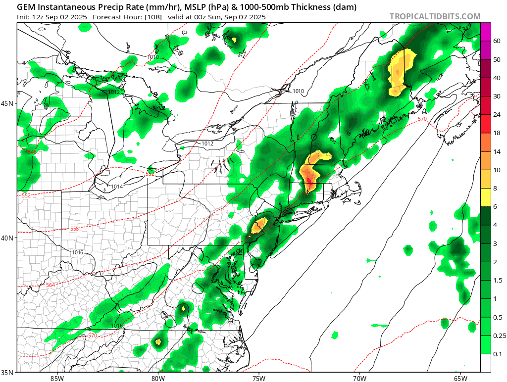
18z GFS tried to be fun
-
Thursday night rain better come true. If not I might got 6 weeks with .1” total.
-
100 degrees in British Columbia
-
That's all we got. Steintember
-
We PHX
-
Yeah I was looking at Euro AI, op looks like crap besides NW. Hopefully WNE/CNE/NNE gets something.
- Yesterday
-
Not in SNE . Forcing and dynamics all north. Pattern has flipped to wetter NNE
-

September 2025 OBS-Discussion centered NYC subforum
Sundog replied to wdrag's topic in New York City Metro
I went to Bear Mountain last year and drove on 7 Lakes Drive and it looked like crap -
I do like that Canada is cold. That killed our 23-24 Nino
-
The colors on the usual suspects (sugar maples, etc) are beginning to show. It’s quite noticeable and several weeks ahead of normal. It’s been right at 40 last few mornings. Do leaves respond more to reduced sunlight or temp?
-
gfs/ggem more W/NW timing for Saturday, Euro op timing is really good for most though. I'm interested. Hodos look more straight than a few days ago, though...was hoping for a few sups with the better dynamics and wind field

-
60kt microburst with .06" rain. ha
-
More NNE. Let’s end Brian’s drought with his roof blown off.
-
Wispy Steinrrus


.thumb.JPG.418e8a9a2902ae687ec35ff4bc0e038e.JPG)