All Activity
- Past hour
-

2026-2027 Record-breaking El Nino
bluewave replied to Stormchaserchuck1's topic in Weather Forecasting and Discussion
It feels like we have started to see non-linear shifts following these major heat releases to the atmosphere from the accumulated excess heat stored in the oceans. If you think about it we had a very similar climate from the late 1800s through about 1982. Sure there was some warming from 1885 to 1982, but nothing all that dramatic. Since the coldest winters of that era occurred in the late 1970s. Then the 1982-1983 super El Niño gave a slight bump to temperatures which remained about steady until 1997-1998. Following the 1997-1998 heat release, the greatest warming occurred in the Arctic several years later from 2005 to 2012. So the state of the Arctic sea ice shifted to much younger around 2007 and continues to this day in the same range. Then the next major heat release in 2015-2016 dramatically warmed our winters to the point that places like NYC only saw their next long term colder winter after 2014-2015 a full 11 years later in 2025-2026. The major climatic shift following 2015-2016 was the rapid warming and ridge expansion east of Japan beginning around 2018-2019 which has lead to this persistent record -PDO run. The heat release in 2023-2024 lead to the warmest CONUS winter to that point. 2025-2026 finished close to the warmest also but our little corner of the world finally got a cold winter after 11 years but the geographic footprint relative to the rest of the CONUS was very small. But that didn’t take away from the fact that it was an enjoyable winter for many here. Nino 1+2 never fully cooled off following 2023-2024 and gave us the Nino-like December 2024 with the record +PNA for a La Niña. Now this is the first time 2 El Niños this strong have occurred only 3 years apart. It feels like the big shift following 2023-2024 was a warming of the EPAC which had been the one region of the planet that had resisted the warming through 2022-2023. Many papers were written about the famous EPAC cold tongue. Now this current warming there has exceeded anything that has occurred in the past. This event into 2027 is going to be the greatest heat release to a higher baseline than all the previous events. So we don’t fully understand the shifts that will occur following this jump to a much warmer climate as we head into the late 2020s and then early 2030s. This EPAC warming since 2023-2024 has been unprecedented.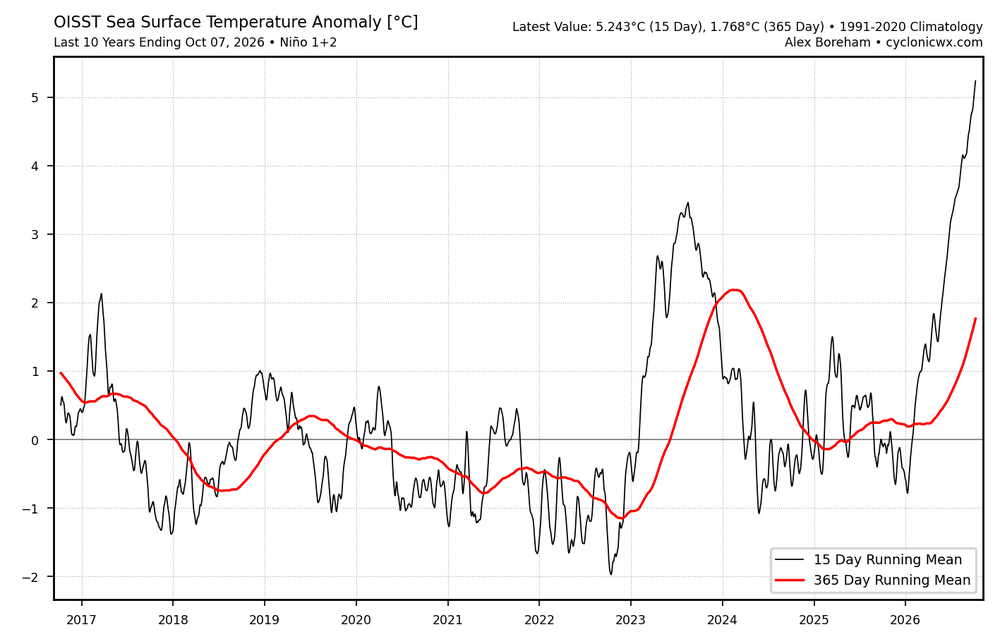
-
What a tough forecast. You have an intensifying likely major hurricane on final approach and are banking on a decapitation to occur in next 12 hours while the system is still intensifying at the moment. Wouldn’t want to be the one sending that messaging. NHC is doing a fantastic job with it. I still think this weakens to cat 1 by landfalll but NHC noted explicitly they are expecting a high end cat 2 when it crosses the coast now
-
37 this morning, didn't think it would get that cold overnight.
-

2026-2027 Record-breaking El Nino
PhiEaglesfan712 replied to Stormchaserchuck1's topic in Weather Forecasting and Discussion
I was originally going to Vermont in late January, but the first Nor'easter happened. I ended up going the weekend of March 7-9, and that point, the winter was just about over. I got temps in the mid-50s/lower 60s each day. I stayed in Manchester, and had to drive up to Weston on the last morning to see some frozen weather. -
-
Eye coming into radar view of KEVX and KMOB now snd it looks very strong
-
 https://sierramedsrx.shop/# best mexican pharmacy for prescriptions
 -
Matt east just posted this on FB. Enhancement for the win around here .
-
We need it. Our reservoirs are dry.
-
Good luck. I know exactly what you are and will be going through. It's a tough road, but definitely worth it.
-
The current price spike may be a turning point for oil demand. Global EV sales have surged, mainly outside of China and US. This is the first oil crisis where an alternative was widely available. https://oilprice.com/Energy/Energy-General/Fuel-Price-Shock-Pushes-Global-Gas-Car-Sales-Below-50-for-First-Time.html
-
41
-
Oh, awesome more weekend rain
-
I know this is banter... but why, because of this? This is the weather for Atlanta.

-
Duke-GT (and any game in the pathway of the storm) shouldn't be played as scheduled either. Human lives are more important than a football game being played at its scheduled time. You can play the game on Sunday or Monday (or even move it to later in the season, if the teams' schedule allows it). Not ideal, but if it saves lives, it's all worth it.
-
antibiotics over the counter and antibiotics п»їbuy antibiotics http://cse.google.com.jm/url?sa=t&url=http://antibiodirect.com prescription antibiotic and https://cyl-sp.com/home.php?mod=space&uid=187953 cheapest antibiotics [url=http://dir.curezone.com/c.asp?http://antibiodirect.com]get antibiotics quickly[/url] buy antibiotics online for tooth infection or [url=http://jonnywalker.net/user/aqdwgzwwtc/]generic antibiotics online pharmacy[/url] generic antibiotics online cheap
-
Interestingly, the side that will be sheared apart, the south side, is much healthier than the north side right now.
-
110mph Cat 2 as of 5am. Close to a major
- Today
-
https://www.cnn.com/2026/10/08/weather/hurricane-isaias-ai-models-google
-
-

2026-2027 Record-breaking El Nino
Jebman replied to Stormchaserchuck1's topic in Weather Forecasting and Discussion
That's a good point, forky. I'd forgotten about the 30 years of warming on top of what is a very strong Nino event. -
Down to 39F this am, off a low of 51F yesterday and 32F the day before…
-
Is se Ridge even a thing in Nino?
-
.thumb.jpg.6a4895b2a43f87359e4e7d04a6fa0d14.jpg)
Central PA Autumn 2026
Yardstickgozinya replied to canderson's topic in Upstate New York/Pennsylvania
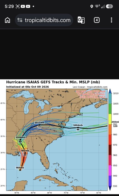
Rainfall timing continues to focus during the day on Sunday before tapering off Sunday night into early Monday/Columbus Day. Total rainfall amounts are generally forecast in the 0.50-1.50 inch range over a 24-36hr duration with a low risk of potential flooding impacts. Wind gusts 35-40 mph are possible over the ridgetops in the Laurel Highlands on Sunday. && Taken from NHC tropical discussion. Based on 0000 UTC surface analysis and satellite imagery through 0430 UTC. ...SPECIAL FEATURES... Hurricane Isaias is centered near 25.4N 88.4W at 09/0300 UTC or 260 nm NNE of Progreso Mexico, moving NE at 12 kt. Estimated minimum central pressure is 969 mb. Maximum sustained wind speed is 90 kt with gusts to 110 kt. Scattered moderate to strong convection is across the eastern Gulf between 83W-90W. Seas up to 32 ft are expected in the area of strongest winds. On the forecast track, Isaias is expected to approach the U.S. northern Gulf Coast on Friday and make landfall within the warning area late Friday or early Saturday. Swells from Isaias are affecting the western and northern portions of the Yucatan Peninsula and will spread northward toward the Gulf Coast on Friday. These swells are likely to cause life- threatening surf and rip current conditions. Please consult products from your local weather office.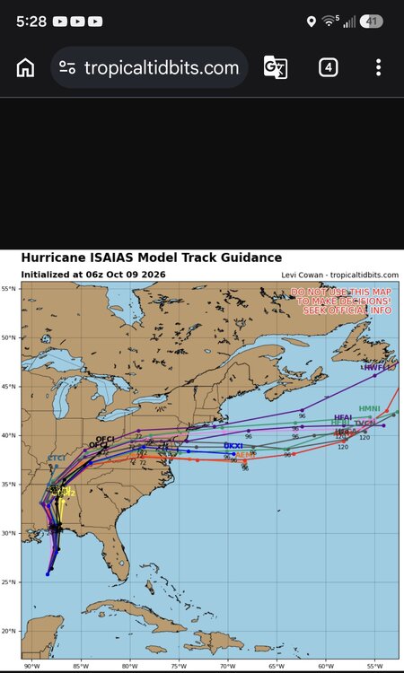
-
36 degrees this morning. Canderson how's the shoulder? Let the therapist torture you now.. Hope you have a speedy recovery.