All Activity
- Past hour
-
 56 out this way; bonfire in the works for tonight. Kids are pumped for smores.
 -
I'm sure these lower temps this morning will start to activate Blizz to soon release a premature snow map in 6 weeks.
-
Hush....not yet, although I have noticed the later sunrises already.
-
Euro monthlies come on the 5th of every month.
-
 58 and chilly morning in Paramus. WOW did that feel good.
 -
51F here.
-
 LB, the heat wave in 1933 ran from July 30 to Aug 2, 98 _ 102 _ 100 _ 98. June 8 and 9 of 1933 also set record highs (95, 97). In 1955 there were also two very hot days in July, 100F on 22nd and 99F on 23rd. Those were records at the time broken later (1957, then 2011). The max on Aug 20, 1983 at NYC was 96F, one below the 1955 date record. 1944 and 1948 were getting quite warm by late July but there were no additional 100F readings to add to those set in August.
 -
Yeah I think we gonna cane.
-
51 here, been awhile since it was this low. I guess were headed toward that dreaded season of winter.
-
COC!
- Today
-
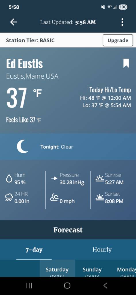
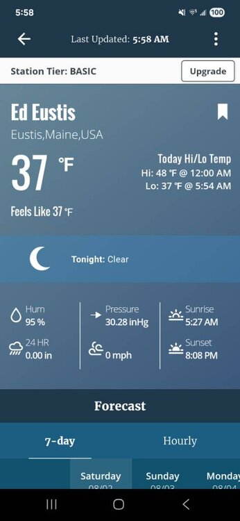
49.1° so far Looks like a warm week but not overly dewy…may have to wait until after next weekend for that.
-
Friends camp Sent from my SM-S921U using Tapatalk
-
Holy crap we mounted up last night. MVL 41/37 METAR KMVL 020940Z AUTO 21003KT 10SM BKN001 05/03 A3030 Local station 41/41.
-
Super refreshing morning 61/60
-
53 this morning here.
-
48.9 woo hoo!!
-
GEFS gone wild! Eps looks good also!

-

Texas 2025 Discussion/Observations
Stx_Thunder replied to Stx_Thunder's topic in Central/Western States
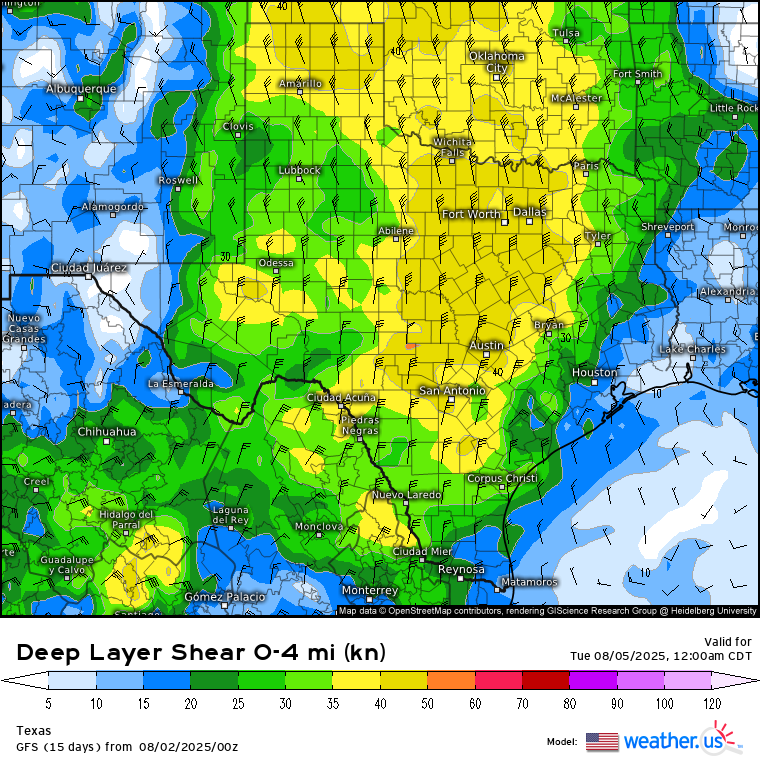
Sunday - Monday looks to be the most convectively interesting the next few days with a potential MCS or at least a few MCCs. Both Euro & GFS holding fairly strong on a formidable mid-upper northerly flow and some unusually decent DL shear this time of year (possibly over 40 knots) over a good chunk of the state on the eastern side of the furnace High moving off to the west. Steering some stout mid-level shortwave energy south through the state. Especially on Monday. Euro has been a bit sketchy on shear value trends in most recent runs. But GFS has been staying mostly consistent the past few days.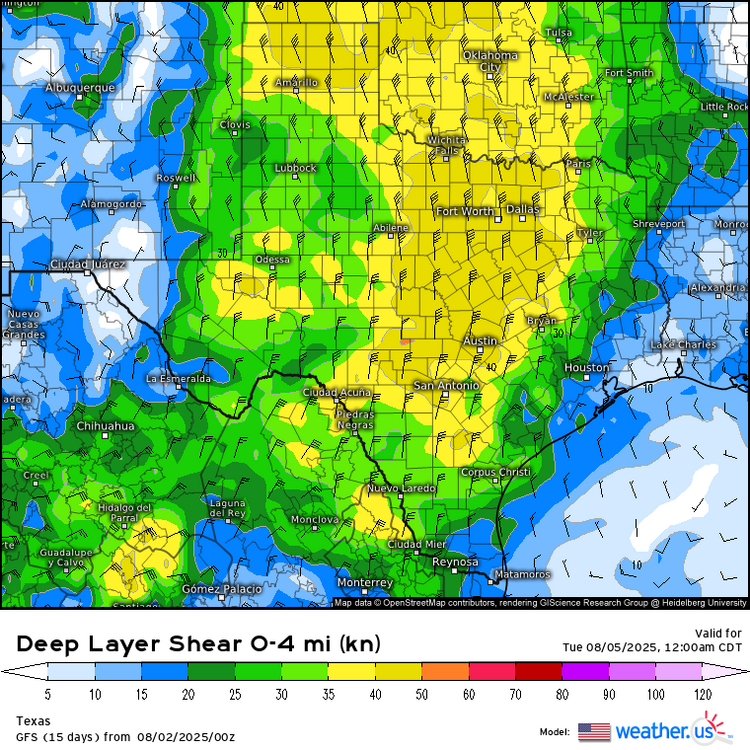
-
WB OZ GFS and EURO now both dry for the week ahead.

-

2025 Atlantic Hurricane Season
WxWatcher007 replied to BarryStantonGBP's topic in Tropical Headquarters
I still think 1-2 TCs before August 20, but I’m increasingly bullish for my peak season forecast (again). -
He’s not wrong about the general steering potential. A US landfall pattern has been there much of the summer, just haven’t had the activity. Don’t need Webb to see it. Once tropical waves start surviving the trek across the more stable tropical Atlantic and reach the SW Atlantic, there will be landfalls.
-
 Totally forgot DCA _ NYC _ BOS ___ ORD _ ATL _ IAH ___ DEN _ PHX _ SEA +1 +.8 +1 +.9 +.6 +.5 +1.5 +1.8 +1.6
 -
Cerro Castor ski resort is still getting heavy snow and it is blowing around. It's deep winter down in deep southern South America and the skiers there are happy. It's gonnabe the scene in the Mid Atlantic come December 2025 on into the first three months of 2026. Remember you heard it first from The Jebman!
-
0Z UKMET NEW TROPICAL CYCLONE FORECAST TO DEVELOP AFTER 156 HOURS FORECAST POSITION AT T+156 : 16.9N 48.9W LEAD CENTRAL MAXIMUM WIND VERIFYING TIME TIME POSITION PRESSURE (MB) SPEED (KNOTS) -------------- ---- -------- ------------- ------------- 1200UTC 08.08.2025 156 16.9N 48.9W 1012 25 0000UTC 09.08.2025 168 18.4N 51.5W 1012 26
-
The CANSIPS busted horribly on its July forecast from a 0.0 month lead, in terms of US temperatures. The Euro is a much better performing seasonal model, but I don't know when its monthly forecasts update. The Euro though performed really badly for last DJF, I'm surprised seasonal models don't do better.. they seem to heavily weight ENSO. The year before (23-24) the Euro kept showing cold H5 over the Mid-Atlantic for the Winter mean. We got almost no snow that Winter, and it was the warmest Winter on record for the CONUS. The -PDO/east-based El Nino analog composite for 23-24 worked very well, though.