All Activity
- Past hour
-
see...I think it's really just whether the sun is shining for a lot of return engagement in this social media. I've come to find over the years there's a coherent increase in the complaint rate based on whether that is the case. Less about temperature and more about sun. Cloudy and dry.... 'top ranked shit day' this and that. I have a stretch of cedar fencing coming in tomorrow ...I had to go out and prep the property line; pretty nasty job toiling in contaminated dirt and old human detritus. This is kitty corner to an urban setting so it's not like toiling in nature's regolith and bucolic Earth. Pretty sure I was turnin dirt and exhuming plastic fragments from 1972 back there. Gross. But I can say...dry and cloudy at 52 F? It was a helluva bargain over having to do that toily task if were 80 F and humid. ho man. it's all relative I guess
-

2026-2027 Strong/Super El Nino
PhiEaglesfan712 replied to Stormchaserchuck1's topic in Weather Forecasting and Discussion
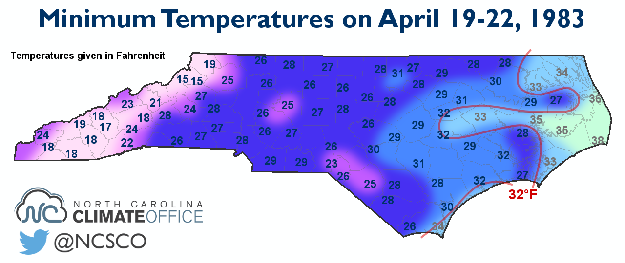
Also, a late widespread freeze/snow event in the Eastern US, as far south as North Carolina on April 19-22:
-

2026-2027 Strong/Super El Nino
GaWx replied to Stormchaserchuck1's topic in Weather Forecasting and Discussion
There was a historic very heavy snowstorm in the SE US on 3/24/1983. ATL got 7.9” of very wet snow, their heaviest snowstorm since Jan of 1940. That even gave Savannah a trace of sleet! ATL also had its snowiest winter (10.3”) since 1939-40 (another El Niño by the way). -

2026-2027 Strong/Super El Nino
Maestrobjwa replied to Stormchaserchuck1's topic in Weather Forecasting and Discussion
I have a Mid-Atl bias--ninas are no good here, so yeah, lol -
Euro is now generally on board, too, though its snow maps look kind of goofy around the Palmer Divide
-

2026-2027 Strong/Super El Nino
40/70 Benchmark replied to Stormchaserchuck1's topic in Weather Forecasting and Discussion
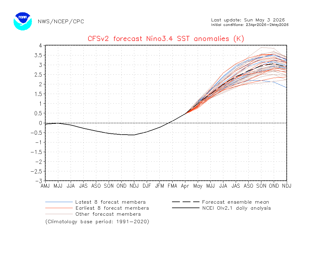
I expect to do a pretty deep-dive on the RONI/ONI relationship in my outlook this year because I feel that is going to be even more crucial than modoki index to be perfectly honest. I don't care if the SST pattern looks modokiish if the west Pacific is a hot tub and we can't pop an appreciable Aleutian low. -
Broke into some solid sun now. What a difference
-
2026-2027 Strong/Super El Nino
40/70 Benchmark replied to Stormchaserchuck1's topic in Weather Forecasting and Discussion
We'll see what happens. I think 1982-1983 is a best case scenario assuming El Niño gets as powerful as some are suggesting. Looking back at the local climo data....winter was even better than I thought. Three storms over a foot in my area. December/January/March were slightly above normal temps and February slightly below normal. Snow pack peaked at 26" on February 11th....bit more than last year. -
Cod fishy
-
2026-2027 Strong/Super El Nino
GaWx replied to Stormchaserchuck1's topic in Weather Forecasting and Discussion
But this CFS run is still showing a RONI-ONI gap of 0.5C (+2.5 vs +3.0). That narrowing is <0.1 vs the JFM gap of 0.56. -
ineeddonuts
-
2026-2027 Strong/Super El Nino
40/70 Benchmark replied to Stormchaserchuck1's topic in Weather Forecasting and Discussion
Not necessarily. -
2026-2027 Strong/Super El Nino
40/70 Benchmark replied to Stormchaserchuck1's topic in Weather Forecasting and Discussion
I like that we seem to be closing the gap between RONI and ONI....I bet we see more of an Aleutian low/SE ridge response if that is the case. 82-83 had decent NE snowfall even though it was warm in the mean. -
We can only hope. The promise of better weather this spring is reminiscent of the promise of a snow storm only 5 days away that never materializes.
- Today
-
this may have been the last winter day in the city until this fall..
-
Was gonna go out and do more yard work today. Too cold and biting with the wind, so I guess it's painting inside instead.
-
Officially I see only 0.05” at RDU for May 1-2: https://kamala.cod.edu/nc/latest.cdus42.RDU.KRAH.html Also, I see only 0.63” at FAY vs 0.91” on the map: https://kamala.cod.edu/nc/latest.cdus42.FAY.KRAH.html It’s as if they put in the wrong map. Maybe that was a forecast map?? But it has GSO right with nothing. Here’s a link to the last 7 days rainfall, which shows 0.44” at RDU, 0.77” at FAY, and 0.16” at GSO: https://kamala.cod.edu/offs/KRAH/2605031100.sxus52.html
-
Only 54 degrees here with the gusty winds. Nasty for early May. Looking forward to mid 70s tomorrow.
-
(002).thumb.png.6e3d9d46bca5fe41aab7a74871dd8af8.png)
Central PA Spring 2026 Discussion/Obs Thread
ChescoWx replied to Voyager's topic in Upstate New York/Pennsylvania
Below is from Mount Holly - Is there one from State College? Thanks! -

2026-2027 Strong/Super El Nino
snowman19 replied to Stormchaserchuck1's topic in Weather Forecasting and Discussion
Despite the wishcasting by a select few weenies on twitter trying their best to wishcast a super El Niño away by saying there is no atmospheric coupling, the actual facts and reality tell a completely different story….there is actually strong ocean-atmosphere coupling (Bjerknes feedback) and it is projected to stay that way: -
E PA/NJ/DE Spring 2026 Obs/Discussion
ChescoWx replied to PhiEaglesfan712's topic in Philadelphia Region
Final seasonal NWS reported snowfall maps -
Next 2 weeks don’t look great. May have to wait until mid June for summer weather
-
This is too much for Raleigh. I got 0.15” there is no way downtown got that much more. Also the farm in Louisburg had less than 0.20” and its SE of Louisburg on that map. So that is likely too high as well. Honestly cut these totals in half
-
NGL if the models still support some snow falling in WV I'll be taking a nice hike out there
-
2026-2027 Strong/Super El Nino
GaWx replied to Stormchaserchuck1's topic in Weather Forecasting and Discussion
Thanks, snowman. Indeed, it’s forecasting a 1982-3 redux as of now. The corresponding latest CFSv2 ONI forecast is at +3.0C, which is maintaining the recent ~0.5C difference between ONI and RONI: