All Activity
- Past hour
-
You’re a solid 8”-10” ahead of me now. But I think that sort of what you thought in your long range, right?
-
Wish folks had more respect for the index methodology - it's correct the vast majority of times...not sure why or if there is reticence to either understand it, or implement ... but Monday was never signaled from that source and I painstakingly applied that logic and analytic content to the discussion over the last week... It's also this group frankly. In the face of presumptive/prohibitive limitation that is there, in place, the model run that defies those mitigations is immediately pimped out. Oh well.
-
Are boobie lows considered “weather porn”? Inquiring minds and all that
-

Feb 10-11 Mid Week Minor Event - Ride the hot hand?
WxWatcher007 replied to HoarfrostHubb's topic in New England
Worst forecast of the season for me. -
Just another 150 years for another Worcester or Springfield
-
It's telling when you see that a thread has had no posts in almost an hour. And the last post is about no one posting. lol
-
dreams of SLGT risks
-
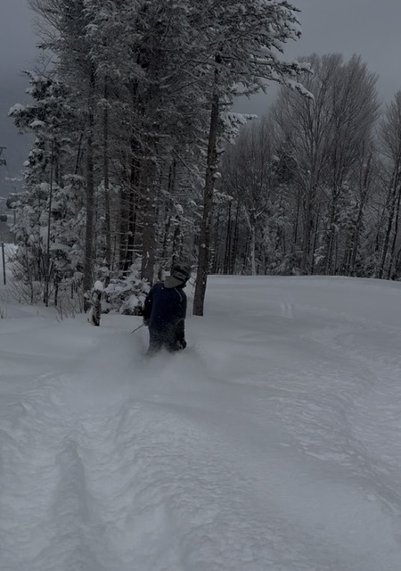
The skiing is out of this world. And this is not some woods in the middle of nowhere, this is chair served terrain
-
Ensembles work by creating multiple perturbations to the initialization. They have a way of knowing where the largest errors are likely to occur and run from there. But perturbations are technically introduced error at initialization. So if you’re overall trending toward fewer “hits” as we approach the short range that’s a bad sign.
-
I like the color blue
-
this. can't fish, can't garden.
-
The back of winter appears to be broken on those maps. With normals climbing that's probably 40-45 degrees here
-

Feb 10-11 Mid Week Minor Event - Ride the hot hand?
The 4 Seasons replied to HoarfrostHubb's topic in New England
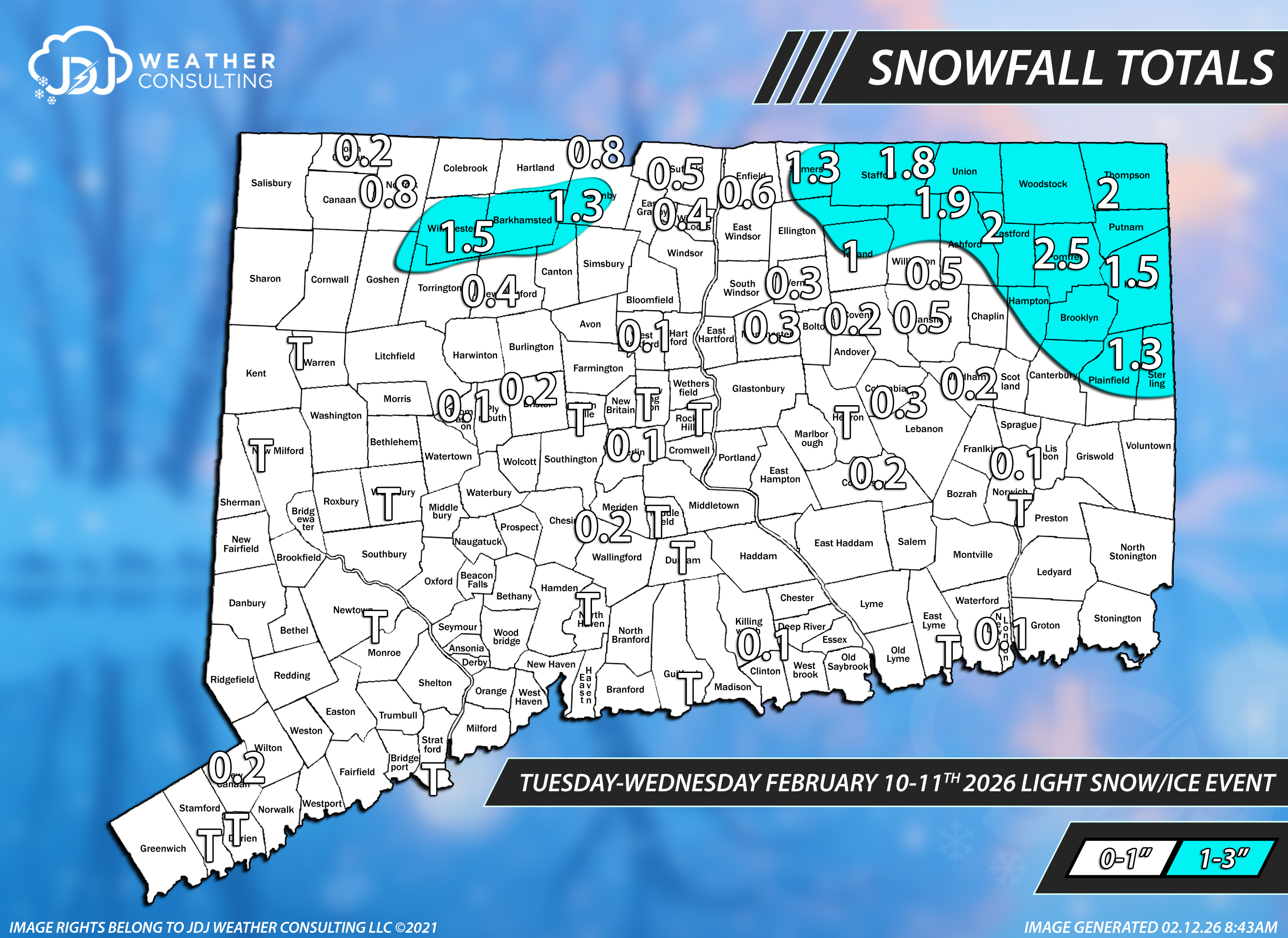
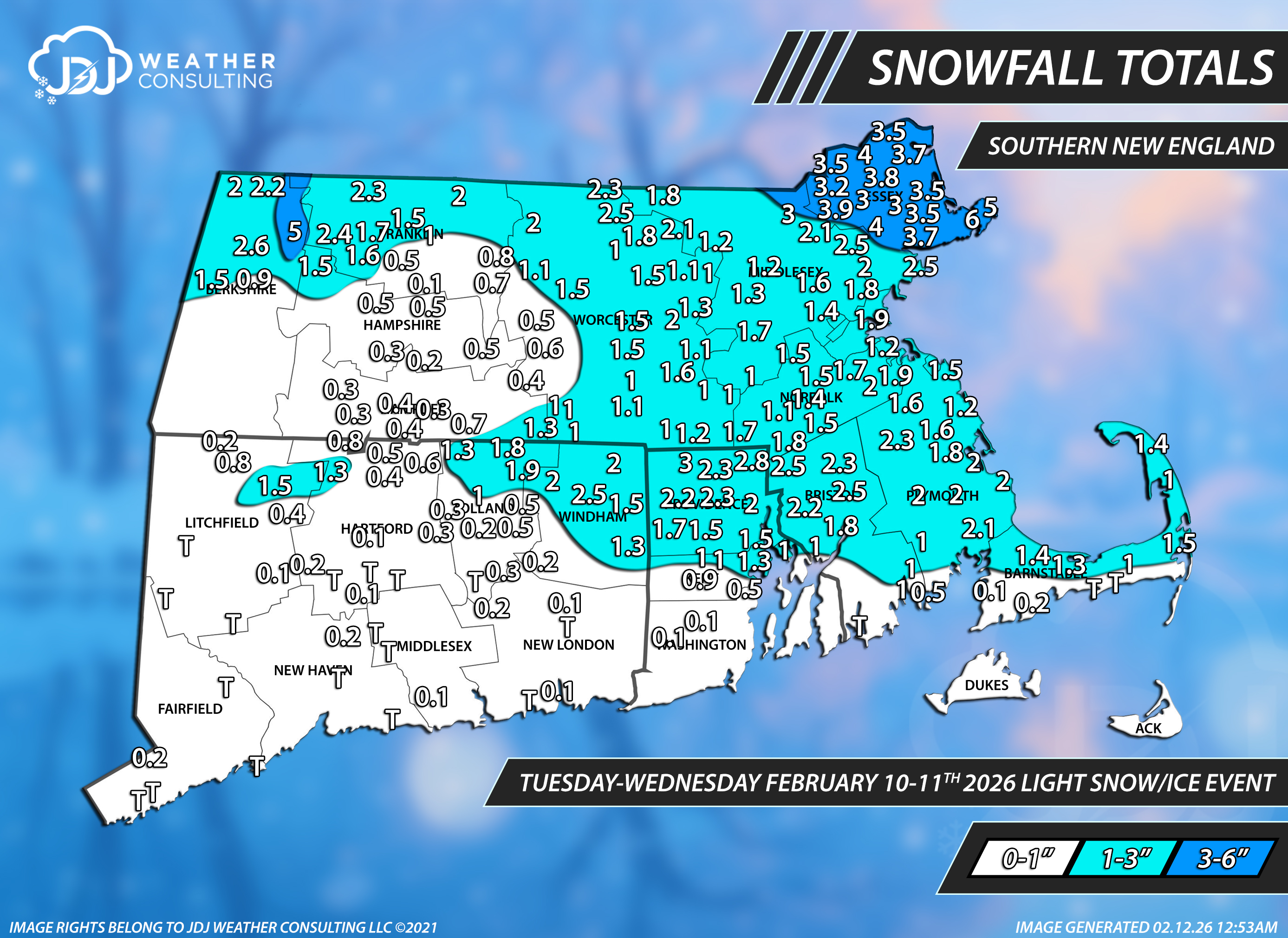
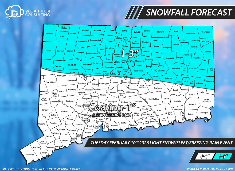
Snowfall totals from this light mixed event. Definitely a little on the under in the 1-3 in nrn CT and the C-1 was mostly a light coating of snow/sleet to nothing near the shore, overall it wasn't terrible. C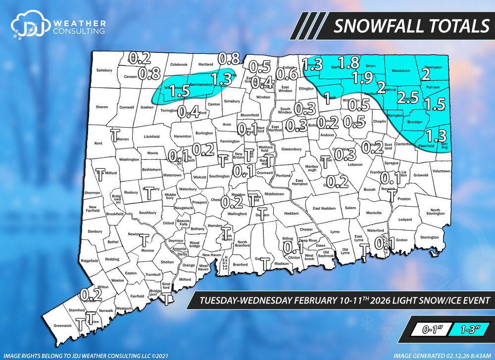

-

Is we back? February discussion thread
40/70 Benchmark replied to mahk_webstah's topic in New England
MAY COUNTDOWN TO SNE SEVERE BLUE BALLS!! -
 *Looks for that Lucy Charlie Brown gif where she pulls the football away at the last second*
 -

Winter cancelled/uncancelled banter 25/26
donsutherland1 replied to Rjay's topic in New York City Metro
Some further commentary in the wake of the ECMWF-AIFS now consistently outperforming the ECMWF and Google DeepMind's rapid improvement in hurricane track forecasting on how I expect AI to transform the meteorological space over the next decade or two. My thoughts follow with the caveat that I do not possess a crystal ball. This is based largely on how AI has evolved very recently and the assumption that further improvements and integration with other technologies will occur. Prompt libraries executed by agentic AI would interpret/translate modeled outcomes at a local and even hyper-local street-by-street level, generate basic and customized maps/visualizations by tapping into Python and other programming libraries, disseminate a wide range of personalized information through Apps, etc. This will radically change existing value propositions. It would shift substantial value to the public and consumers/users of weather information. It would also upend business models based on charging for maps and graphics that are often based on freely available raw data simply due to the public's lack of access to the ability to generate such graphics on their own (programming knowledge to software). The evolution of AI would also dramatically change the nature of the meteorology profession from routine forecasting to communication of risk/uncertainty, mesoscale/microscale specialist, emergency response consulting, etc. I suspect that fairly routine things like 7-day forecasts, marine forecasts, hourly forecasts will be largely automated in a decade or two. Humans will focus more on communicating risk, identifying rare outcomes that could lie outside the AIs' training, advising proactive responses (evacuations, school closures/delays, etc.), and providing judgment in complex situations. AI would largely devalue the hype-based business models that have proliferated on social media to the detriment of professional credibility and public well-being, as the AI-driven outcomes available at little or no cost would be vastly superior to the hypecasters' products, services, and click-bait. Moreover, the AIs will allow users to verify the accuracy of the AI-driven forecasts enhancing credibility for the AI products/services. AI will also integrate large amounts of additional information to provide impacts assessments. AI will translate weather data into information concerning supply chain disruptions, energy demand, insurance exposure, traffic patterns, effects on crops, etc. These AI-driven impact models will likely be offered by major AI companies (Google, etc.) at much lower cost than under today's business models. That will also shift value to the AI companies who will be providing the service and the users of such information who will benefit from discounted pricing. Second order effects could also be unlocked for consumers of products/services (grocery prices, energy prices, etc.). In the end, this won't be the first time that technological change led to broad transformation. Almost certainly, it won't be the last time, either. -
Kevin is right...there could be some snow showers (even some squalls tomorrow night) but a dry boundary layer might be an issue. That's a pretty potent shortwave diving southeast with very steep mid-level lapse rates
-
Is we back? February discussion thread
40/70 Benchmark replied to mahk_webstah's topic in New England
I think through the third week of March would work for me, but once we hit the last week of March climo nosedives and 95% of threats are elevation dependent. -
Do you two need a cig?
-
I couldn’t agree More. And let’s throw all our chips on the table and gamble with riding the line. If it fails…so be it, and let’s get spring in here by late March(although that’s probably a pipe dream lol). But you know what I mean.
-
Is we back? February discussion thread
40/70 Benchmark replied to mahk_webstah's topic in New England
I'm not a pro, but thanks. I can hold my own, but there are certain aspects where Will and Scoot really distinguish themselves in terms of avenues to success with respect to phasing potential and overall pattern progression. Sounding interpretation is one area that I am really deficient relative to them. -
From what I heard, a shift towards colder weather in March I guess mid March is the target… It’s gonna be more MJO driven. So we’ll see how that goes. Maybe in the meantime, we can ride the lightning until then. Personally I hope it’s earlier.
-
I think we're gonna see some more teases before it's eventually over. It just won't die completely on ensembles. Even the 6Z GEFS has a couple big hits on it when 00Z had zero. EPS and AIEPS have several. I'd give it a <10% chance but it's worth keeping one eye half opened. lmao, i saw that, MJOs favorite model now that the NAVGEM is gone
-
Will ORD get above 0.9” this month? .
-
It’s all good. Just remember too, that most of us are hobbyists, and are not pros. We do things that are gonna probably annoy folks like you and Will at times…I think we all get that. And I think I speak for a lot of guys in here(along with myself), when I say that we’ve learned a ton from professionals such as yourself, Will, FXWX, and Ray, and Steve too, that we can’t put a price on. Sometimes we get excited, and may post or say things that may be laughable…but it’s mostly only because of enthusiasm. Anyway, I agree with what you laid out a few posts back about the long wave pattern that may be coming later in the month, and early March. Thanks for the explanation and insight too.
.thumb.png.4150b06c63a21f61052e47a612bf1818.png)