All Activity
- Past hour
-
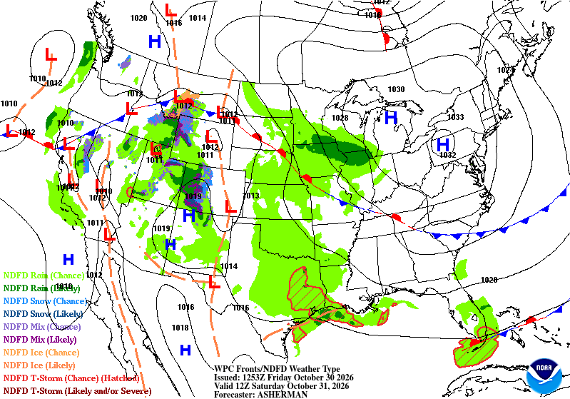
Decent call here. Wet wx possible in the W sub.
-
maybe because soaking rains are so common around here..........
-
-
trying to forecast one blockbuster snowstorm prior to winter is the same as trying to predict you will win the million dollar lottery - did anyone predict the blockbuster snowstorms prior to last winter ?
-

2026-2027 Record-breaking El Nino
WinterWolf replied to Stormchaserchuck1's topic in Weather Forecasting and Discussion
Past performance, doesn’t guarantee anything. -

2026-2027 Record-breaking El Nino
stadiumwave replied to Stormchaserchuck1's topic in Weather Forecasting and Discussion
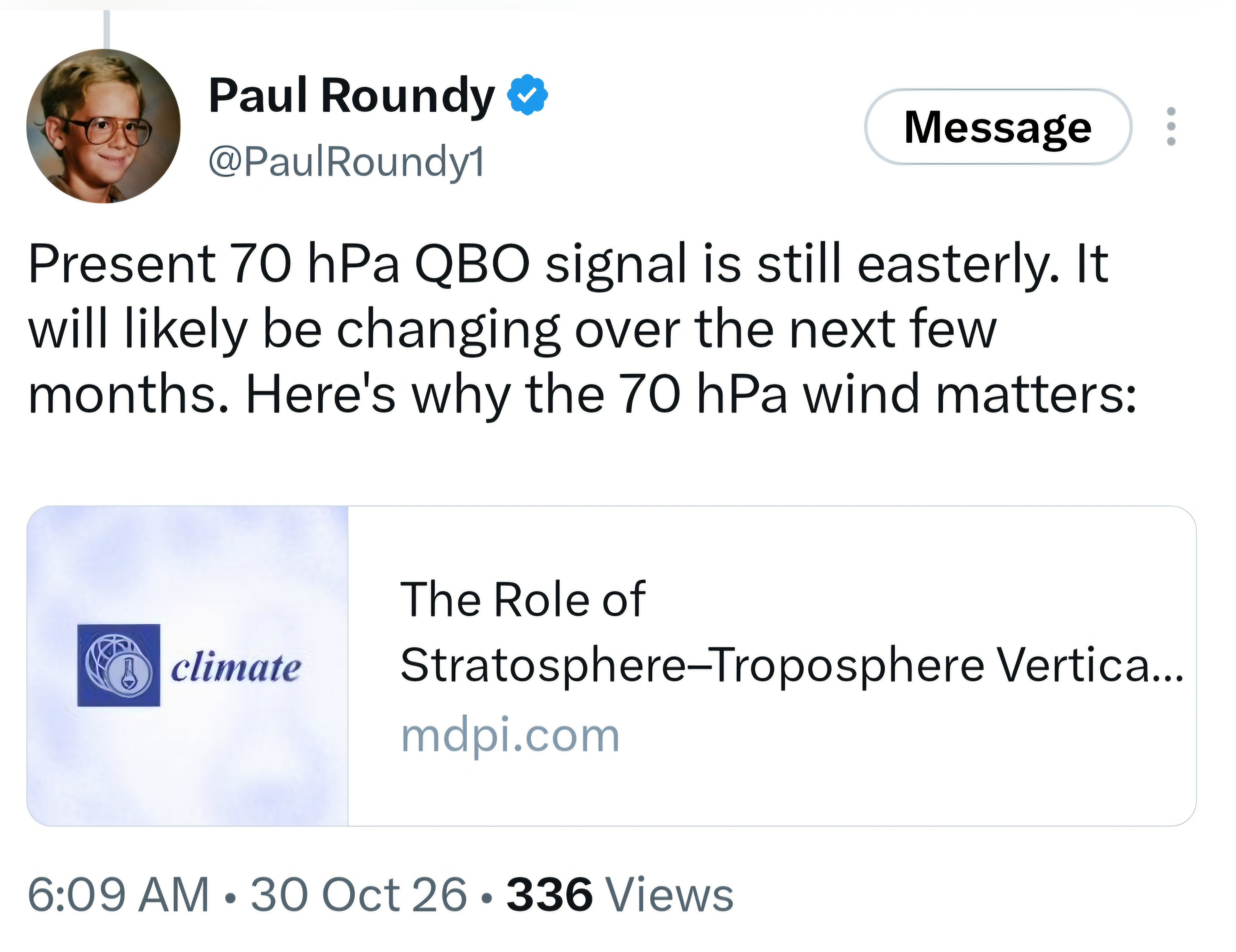
Great thread on SSW research & I screenshot Paul's reply in case someone misses it. Found interesting. He links a paper. https://x.com/Recretos/status/2115980492876984698?a=SxXaM4VN5NxdefH8xsg&s=19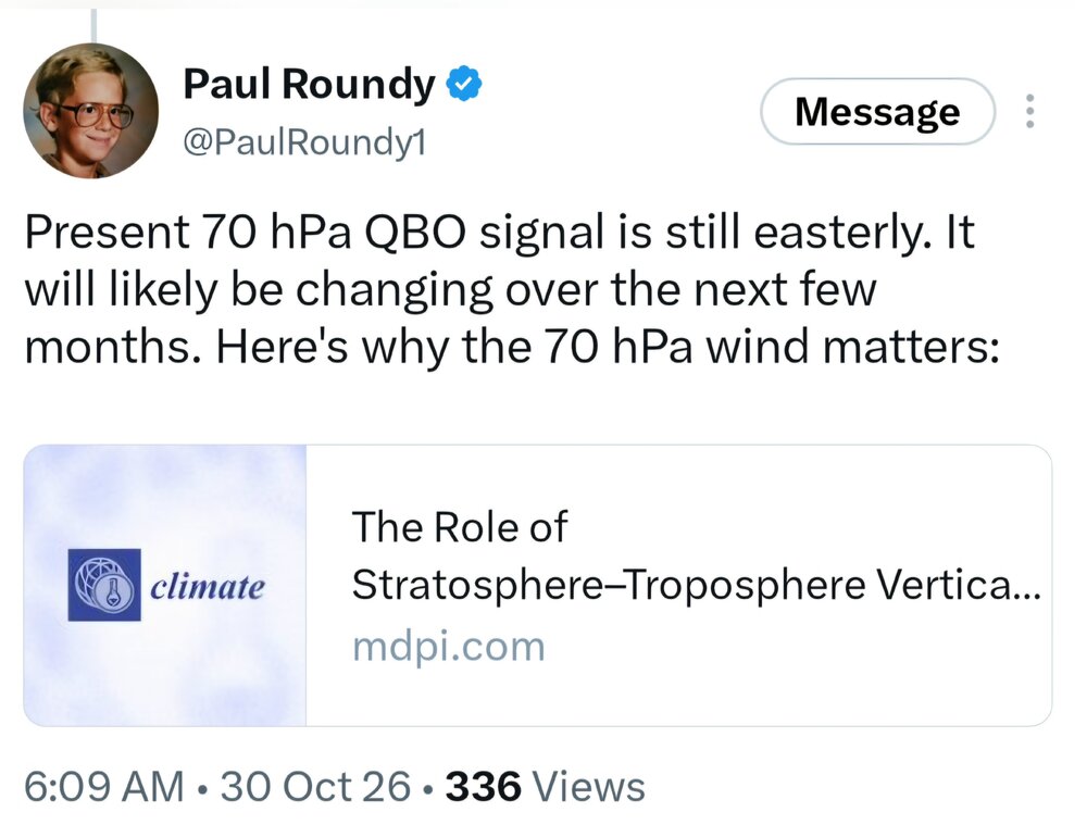
-
October 30 1951: An early snow storm drops as much as 8 inches of snowfall in north central Minnesota. Mora had 8 inches, while Long Prairie received 6 inches. Glenwood, Little Falls, Morris, and New London all had 5 inches of new snow. Meanwhile, surrounding areas received a couple of inches. 1936: An intense dust storm causes damage in Central Minnesota. Heavy wind damage is reported in Stearns County. For Friday, October 30, 2026 1925 - Nashville, TN, was blanketed with an inch of snow, their earliest measurable snow of record. (The Weather Channel) 1947 - The Donora, PA, smog disaster finally came to an end. For five days an inversion trapped impurities in the lower atmosphere over the Monongahela Valley killing 20 persons, and leaving more than 2000 others sick. (26th-30th) (David Ludlum) (The Weather Channel) 1987 - Severe thunderstorms in Oklahoma produced golf ball size hail and wind gusts to 74 mph near the town of Gould. Unseasonably warm weather prevailed across the central U.S. Temperatures warmed into the 80s form Texas to the Lower Missouri Valley. (Storm Data) (The National Weather Summary) 1988 - Ten cities in the Upper Midwest reported record low temperatures for the date. The morning low of 20 degrees at South Bend IND was a record for October, and lows of 18 degrees at Grand Rapids MI and 20 degrees at Fort Wayne IND equaled records for October. The low of 2 degrees at International Falls MN smashed their previous record for the date by 11 degrees. Syracuse NY received 2.9 inches of snow to establish a record for October with 5.7 inches for the month. (The National Weather Summary) (Storm Data) 1989 - Temperatures soared into the 70s in the northeastern U.S. The record high of 73 degrees at Alpena MI marked their sixth straight day of record warmth. In the western U.S., Klamath Falls OR reported a record low of 19 degrees. (The National Weather Summary) Observances: 30 Fri National Text Your Ex Day 30 Fri National Checklist Day 30 Fri National Candy Corn Day 30 Fri Nevada Day 30 Fri National Breadstick Day 30 Fri Create a Great Funeral Day 30 Fri Mischief Night 30 Fri National Publicist Day 30 Fri National Speak Up For Service Day 30 Fri National Treat Your Pet Day 30 Fri Haunted Refrigerator Night
-
Surprised no chatter on here about the chances for a soaking rain later next week. About 6 days out but has been varying model support for a few days now. Details to be determined but decent chances our prolonged dry and pleasant weather will be coming to an end before next week is over. Would bring an end to the 2026 foliage season for the N&W crew as well. Opening bid from WPC has 1.5-2.5" subform wide.
-
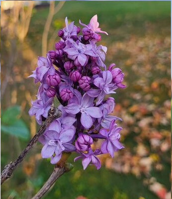
Off note/op ed: Relatives currently across southern Michigan are experiencing a Lilac bloom here nearing November ... and the photos/evidence I've seen, these are robust bouquets ... Not a mere floret or two. I began noticed this here in New England beginning ~ 7 years ago, and since it's been sporadic... year to year.. Small bud swells with a few cracked open, a small flower here and there- I've actually even witnessed seasonally dumbfounded bumble bee sniffin' around. Not the bigger bouquets you get in May...but definitely "silently alarming" for climate aware types like myself - and definitely not enough of total population awareness... Nothing like this though, Point being, the phenomenon is increasing in frequency and production - one among a vast compendium of different climate change ramifications that are ongoing. I was just reading about thermokarst phenomenon ... permafrost detachment landslides, and glacial thrust events, all of which have both increased, but at an accelerated occurrence rates over the past 30 years. The shit over in Tibet was civility being in the wrong place in the wrong Millennium when a detachment took place...etc. I know that global climate change is fake and that profligate exploitation of fossil fuels is part of human kind's divine right and provenance of all Earth kingdom come ... has nothing to do with acceleration/adding to it. And that science is fake... But, I guess somewhere between the enormity of whole villages and their occupants being swept away, and the acrid stench of incarcerating poly-aromatic hydrocarbons ...there exists an incredible beauty like bouquet that has no right to exist at this time of year. Feels a bit like a forbidden fruit though ... definitely a guilty pleasure. First cousin can be just too hot to leave alone I suppose...
-
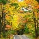
Yep, maples are at peak in my nhood, some are dropping leaves. Oaks are finally showing orange/brown/yellow and not all green. Overall, color is great! Peak here will be around Nov 5th, which is roughly average for my neck of the woods. Will be excellent color for a spooky halloween eve.
-
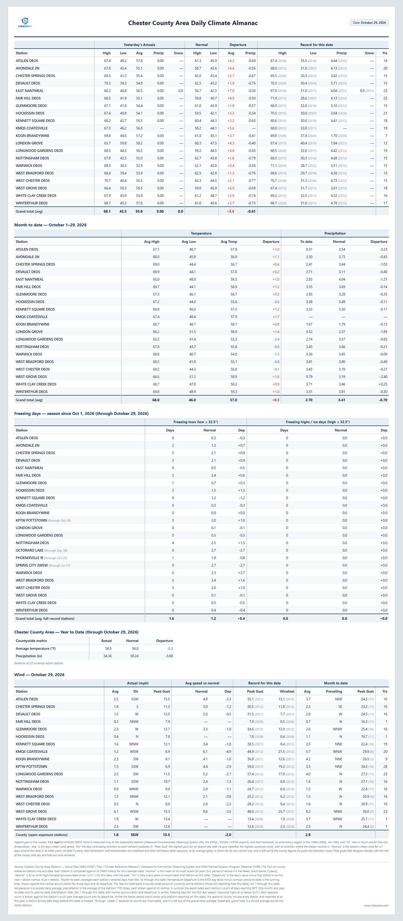
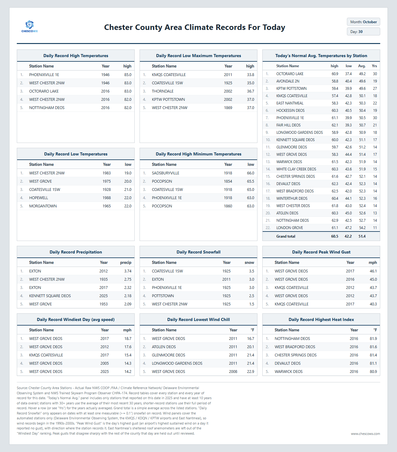
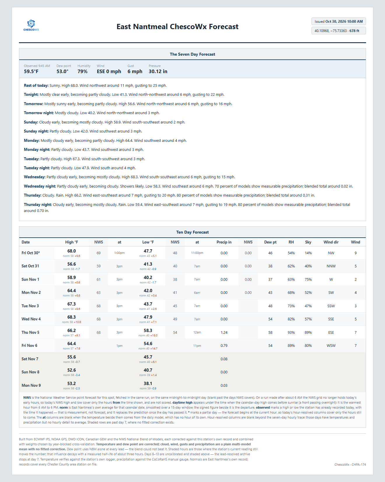
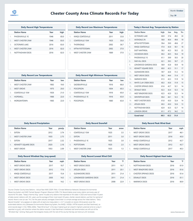
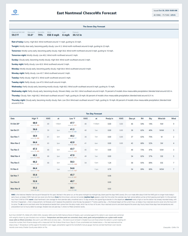
Of note on this date back in 1946 Phoenixville 1E hit 85 degrees and the county as a whole averaged 83.3 for a high...making it our warmest October 30th since records began in 1890. Nothing like that today but it will be very mild for the end of October with highs from upper 60's in ridge locations to the low 70's in valley spots. This is about 7 degrees above normal with lows tonight in the upper 30's to near 40. By Sunday morning we should see lows in the mid 30's to low 40's, not far from freezing in the colder valleys! Temperatures will be near normal this weekend but by Monday we warm to the upper 60's which is 3 to 8 degrees above normal. It has been a while since our last rain but our next soaking rain looks to arrive Thursday with around 1.2" possible according to the ChescoWx model.
-
It’s a very solid forecast. One blockbuster is the difference between an above normal season or struggling to get to 10”. We saw this in both 82/83 and 15/16 and on the opposite side 72/73 and 97/98. It’s an eggs all in one basket situation. .
-

E PA/NJ/DE Autumn 2026 Obs/Discussion
ChescoWx replied to PhiEaglesfan712's topic in Philadelphia Region
Of note on this date back in 1946 Phoenixville 1E hit 85 degrees and the county as a whole averaged 83.3 for a high...making it our warmest October 30th since records began in 1890. Nothing like that today but it will be very mild for the end of October with highs from upper 60's in ridge locations to the low 70's in valley spots. This is about 7 degrees above normal with lows tonight in the upper 30's to near 40. By Sunday morning we should see lows in the mid 30's to low 40's, not far from freezing in the colder valleys! Temperatures will be near normal this weekend but by Monday we warm to the upper 60's which is 3 to 8 degrees above normal. It has been a while since our last rain but our next soaking rain looks to arrive Thursday with around 1.2" possible according to the ChescoWx model.
-
 canadian pharmacy service and canadian pharmacy rx online canadian drugstore http://www.margaron.ru/bitrix/redirect.php?event1=&event2=&event3=&goto=http://canpointerx.shop cipa canada online pharmacy or https://bold-kw.com/user/abssmmwjkd/?um_action=edit best rated canadian pharmacy [url=https://www.google.co.uz/url?sa=t&url=https://canpointerx.shop]canadian pharmacy ltd[/url] online pharmacy canada and [url=https://www.liveviolet.net/user/wznrlvyfvv/videos]best canadian pharmacy[/url] canadian pharmacy meds
-
 Agreed, maintaining cold anamolies for two months will be extremely difficult. Especially based on the performance of March recently. .
-
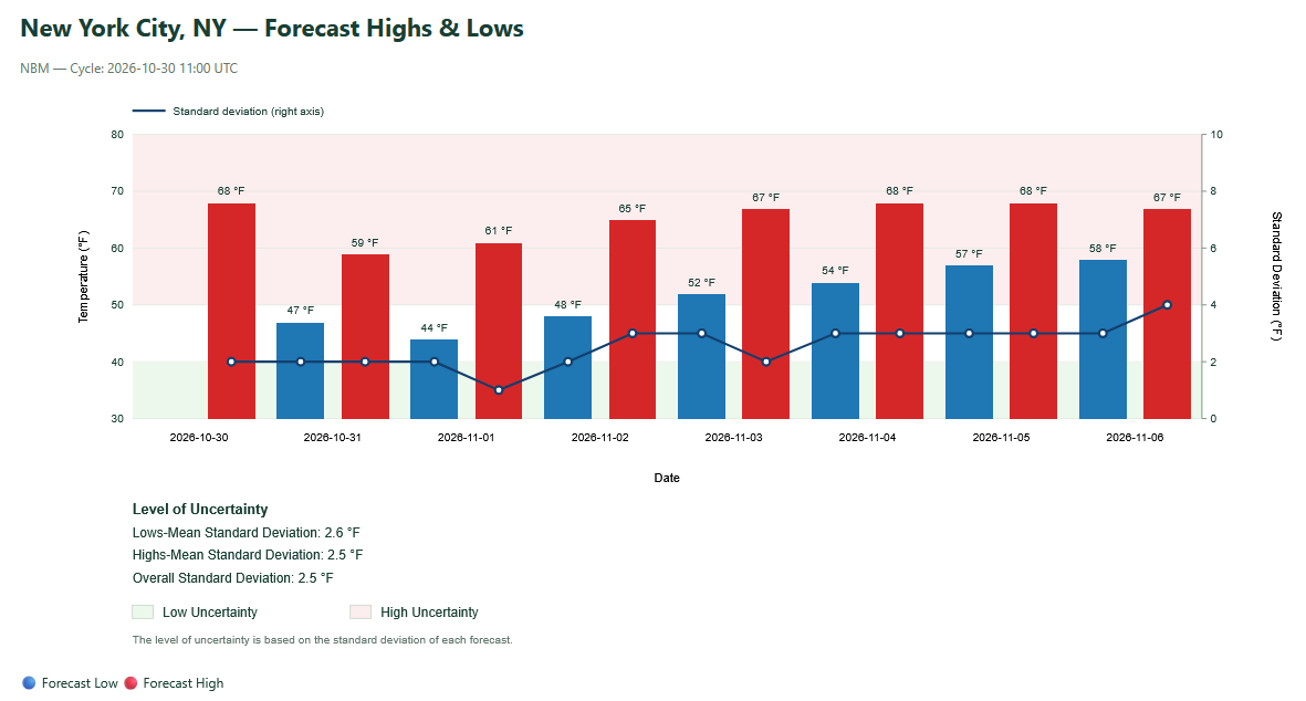
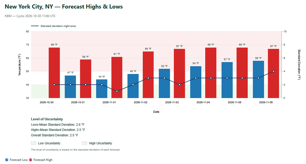
The latest NBM continues to show a mild start to November for the New York City area.
-
61.3/49 Tooooorch
-
Most of these winter outlooks are just guesses. Last year who had below normal temps for DEC-Feb and 50-60 inches of snow for us?!?!
-
It has been a near perfect foliage season. Even without any rain the ground isn't really drying out and, strangely, a few light freezes hasn't ended the growing season. I'm amazed at how healthy and deep green my front "lawn" is.
-
62 currently…gonna be gorgeous.
-
It really is ridiculous. That's literally 80% of our winters the past decade
-
temp over 60 now, where's the wind ?
- Today
-
Nonsense - he is predicting 10 - 40 inches total snowfall for Zone 4 ???? Why doesn't he just say he has no idea..................plus he seems so sure the early polar vortex disruption will be a short one and December will be a mild basically snowless month. He is one of the very few reputable METS online taking that chance before the vortex disruption even started........
-

E PA/NJ/DE Autumn 2026 Obs/Discussion
The Iceman replied to PhiEaglesfan712's topic in Philadelphia Region
I wouldn't be so sure of that, GFS has a cold bias in the long range. Several times it's show huge cold shots at the end of the run and so far it's just been can kicking. -
K3M7 - Lafayette TN KK61 - Beloit KS KHSR - Hot Springs SD KLIU - Littlefield TX KN66 - Oneonta NY PAAE - Ouzinkie AK PANO - Nondalton AK PFKK - Kokhanok AK