All Activity
- Past hour
-
And the low to the east of the main low
-

The “I bring the mojo” Jan 30-Feb 1 potential winter storm
GaWx replied to lilj4425's topic in Southeastern States
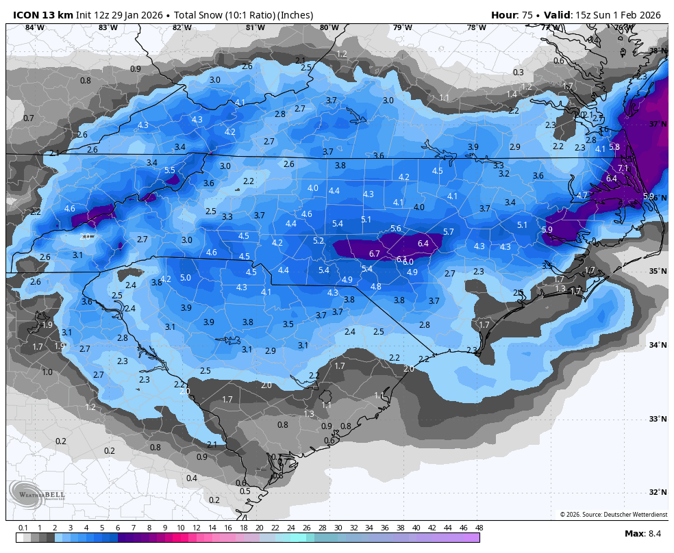
Icon heaviest snow in NC just N of Fayetteville and NE: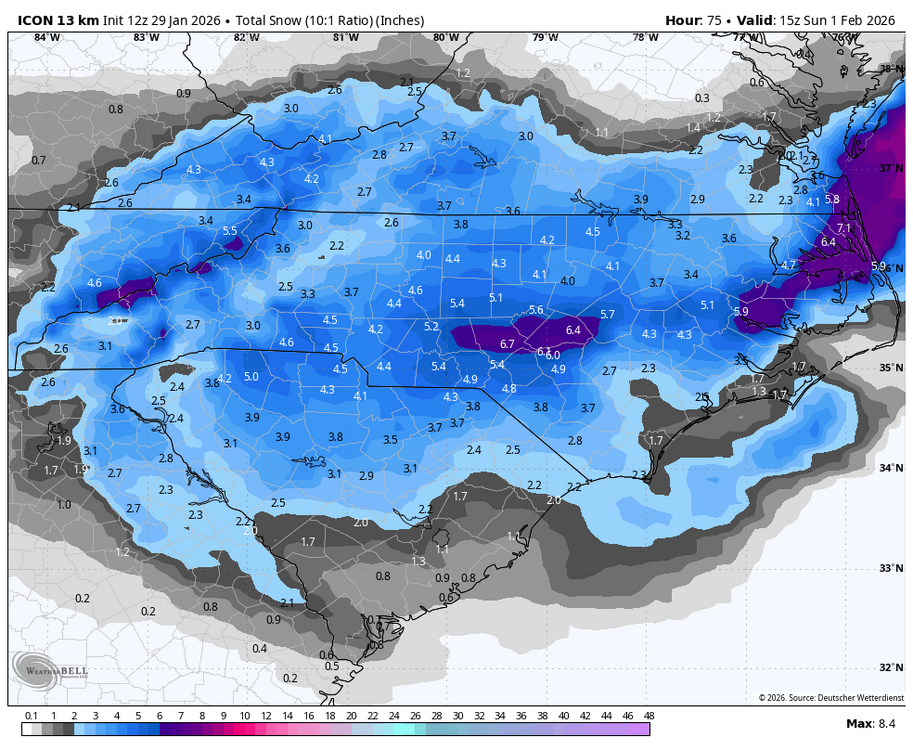
-

Possible coastal storm centered on Feb 1 2026.
JKEisMan replied to Typhoon Tip's topic in New England
On the other hand the Rufus ticked west, I call it a wash. Haha -

The “I bring the mojo” Jan 30-Feb 1 potential winter storm
Buddy1987 replied to lilj4425's topic in Southeastern States
Wonder what type of verification scores it has.. looks very much like FV3/GFS -
We would of had a big snowstorm on our hands if H5 low would have been further north instead of near the Southern Mid Atlantic. They will be seeing a nice snowstorm with strong winds ( wouldnt be shocked to see blizzard warnings)
-

The “I bring the mojo” Jan 30-Feb 1 potential winter storm
ADB83 replied to lilj4425's topic in Southeastern States
What’s interesting about this run is it’s the polar opposite of what that model has been doing. Nobody has been quoting it in a thread because it’s been the worst case scenario for days. Until now apparently. . -

Possible coastal storm centered on Feb 1 2026.
RUNNAWAYICEBERG replied to Typhoon Tip's topic in New England
Reggie ticked east. Life support alert activated… -

The “I bring the mojo” Jan 30-Feb 1 potential winter storm
ncforecaster89 replied to lilj4425's topic in Southeastern States
Gotta get back to work, myself, but wishing ALL of us the best outcome, possible. -
The RGEM run isn't encouraging. Worst run in several cycles. And the excellent run-to-run consistency dating back a few days further decreases the chances of last minute positive changes.
-

Pittsburgh/Western PA WINTER ‘25/‘26
TimB replied to Burghblizz's topic in Upstate New York/Pennsylvania
Interested to see if we get better radiational cooling conditions tonight and/or tomorrow night and see how cold we can go, or if it’ll just be kinda meh like the last few nights. -

The “I bring the mojo” Jan 30-Feb 1 potential winter storm
wncsnow replied to lilj4425's topic in Southeastern States
The RRFS (Nams replacement) is looking better for a lot of us.thumb.png.92c5afe894eda75a03ffc4240c24072b.png)
-
The piles and banks are huge and I atribute that to the higher than expeced water content in the snow. Something to keep in mind as we move towards spring.
-
I personally think it gets better from here. ICON has a perfect low placement, just not alot of moisture
-

Richmond Metro/Hampton Roads Area Discussion
wasnow215 replied to RIC Airport's topic in Mid Atlantic
Same as 6z -
The “I bring the mojo” Jan 30-Feb 1 potential winter storm
ncforecaster89 replied to lilj4425's topic in Southeastern States
Agree. Given it’s track dependent on the coastal low and we still have a ways to go on nailing that down, it’s difficult to pinpoint where that’ll be. -
Richmond Metro/Hampton Roads Area Discussion
wasnow215 replied to RIC Airport's topic in Mid Atlantic
This is what I was saying about the early morning models 6Z… Nothing had snow literally or very little snow that I saw except for the European. Let's see what the GFS does this time. It would be the European against the world for RVA unless the Canadian has something -
 ICON with a nice bump NW, coastal areas back in play. Maybe we can back into some light snow at least?
 -
The “I bring the mojo” Jan 30-Feb 1 potential winter storm
wncsnow replied to lilj4425's topic in Southeastern States
There's a reason the old saying goes- "upper level low, weathermans woe" -
I haven't looked closely but it seemed to be incorporating very high liquid to snow ratios. The QPF forecast map doesn't look that unreasonable, especially considering the lag. NWS offices also have to account for the small possibility that this shifts back NW at the last minute. They don't want forecast whiplash.
-

The “I bring the mojo” Jan 30-Feb 1 potential winter storm
BooneWX replied to lilj4425's topic in Southeastern States
The RDPS tilts just a tick too late. A game of inches. -

February 2026 Medium/ Long Range Discussion: Buckle Up!
stormtracker replied to Weather Will's topic in Mid Atlantic
I have no optimism regarding the next ten days. By the time the next system it’s gonna be warm. Prove me wrong. Just bitter af over here. -
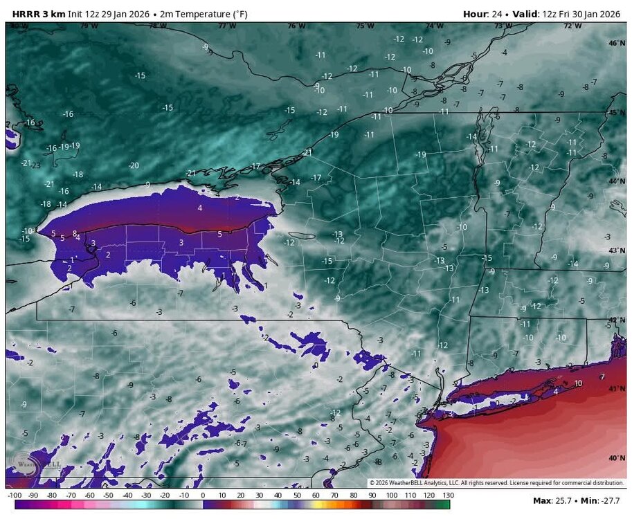
Record lows tonight ?
-

The “I bring the mojo” Jan 30-Feb 1 potential winter storm
wxdawg10 replied to lilj4425's topic in Southeastern States
like an extremely twisted game of weather russian roullette. Someone in this area will be lucky to get 2 inches -
Guys business is about to pick up in here. Not that it should be any surprise [emoji1787] .
-

The Jan 31 Potential: Stormtracker Failure or 'Tracker Trouncing
hsq replied to stormtracker's topic in Mid Atlantic
966mb low 200 nmi SE off the coast of cape cod at the end of the run! i'd wish sailors enjoyment but that certainly would not be fun to get stuck in


.png.622ee78cd6b3e3e3a65ad084bae98246.png)


