All Activity
- Past hour
-

Septorcher 2026 Discussion - Endless Summer
Brewbeer replied to Damage In Tolland's topic in New England
I have a couple of low spots than need filling from stumps that have been rotting away over the decades, have been holding off until we get some rain -
Still to see where the ridge forms mid month for a warmer period - 9/14 - 9/18th tendency has been more SW and we ride the periphery, but there have been several runs between and back and forth from the gfs and eur on a more expansive EC ridge. Whatever warmup we realize the period beyond the 18th looks to have a brief but crisp cooldown in the period till the equinox.
-

2026-2027 Record-breaking El Nino
forkyfork replied to Stormchaserchuck1's topic in Weather Forecasting and Discussion
how many struggling independent ski resorts is this nino going to put out of business? -
Records: Highs: EWR: 98 (2015) NYC: 97 (2015) LGA: 95 (2015) JFK: 92 (2010) Lows: EWR: 50 (1940) NYC: 52 (1871) LGA: 54 (1984) JFK: 50 (1962) Historical: 1900 - The greatest weather disaster in U.S. records occurred when a hurricane struck Galveston TX. A tide fifteen feet high washed over the island demolishing or carrying away buildings, and drowning more than 6000 persons. The hurricane destroyed more than 3600 houses, and total damage was more than thirty million dollars. Winds to 120 mph, and a twenty foot storm surge accompanied the hurricane. Following the storm, the surf was three hundred feet inland from the former water line. The hurricane claimed another 1200 lives outside of the Galveston area. (8th-9th) (David Ludlum) (The Weather Channel) 1900: A Category 4 storm made landfall in Galveston, Texas on this day in 1900. This hurricane killed between 6,000 and 12,000 individuals, making it the deadliest US Atlantic hurricane on record. The highest point in the city of Galveston was less than nine feet above sea level. The hurricane brought a storm surge of over 15 feet, which overwhelmed the entire island. 1925: In September 1925, South Carolina was in the middle of one of the most widespread and disastrous droughts in the state's history. The NWS Co-op station in Calhoun Falls reported 11 days above 100°F with a maximum temperature of 111°F on this day. 1987 - A tropical depression off the coast of South Carolina brought another round of heavy rain to the Middle Atlantic Coast Region and the Upper Ohio Valley. Showers and thunderstorms produced extremely heavy rain in eastern Pennsylvania, where flooding caused more than 55 million dollars across a seven county area. The afternoon high of 97 degrees at Miami FL was a record for the month of September. (The National Weather Summary) 1988 - Eighteen cities in the south central and eastern U.S. reported record low temperatures for the date, including Roanoke VA with a reading of 42 degrees. (The National Weather Summary) 1989 - Thunderstorms developing along a stationary front produced very heavy rain in the central U.S. Thunderstorms during the late morning and afternoon produced five to nine inches of rain around Lincoln NE, with an unofficial total of eleven inches near Holmes Park. Up to six and a half inches of rain soaked northern and western Iowa. Eighty to ninety percent of the homes in Shenandoah IA, where 5.89 inches of rain was received, reported basement flooding. (The National Weather Summary) (Storm Data) 1998: A severe thunderstorm developed over the southern end of the Las Vegas Valley in Nevada. The storm moved north bringing damaging winds and heavy rain mainly across the eastern half of the metro area. Henderson Executive Airport recorded wind gusts of 80 mph. Air traffic control personnel temporarily evacuated the airport tower. Approximately 15 homes and trailers in Moapa were severely damaged by thunderstorm winds estimated at 80 to 90 mph. 2012: Severe storms impacted the New York City area, forcing a delay of the United States Open. A tornado hit a beach club in Queens, and another brought damage to Canarsie, Brooklyn, New York.
-

Septorcher 2026 Discussion - Endless Summer
SouthCoastMA replied to Damage In Tolland's topic in New England
I overseeded, but thanks to Stein I need to lug a bunch of sprinklers around for at least 5-7 days -
68 / 57 another gorgeous day on tap Warmer the next 48 hours mid - upper 80s maybe a stray 90 in the hot locations inland, ahead of a front that could bring some showers, storms or scattered rain / clouds on thursd. A period of near normal this upcoming weekend before ridge comes east and where it builds will be key in how much warmth can push into the northeast from mid month (next week). Overall warmer in the period beyond Sunday.
-

Septorcher 2026 Discussion - Endless Summer
Damage In Tolland replied to Damage In Tolland's topic in New England
Well 70’s and 80’s all of Sept and into Oct is summer . -
JB says 97-98 is the best match for this winter.
-

Septorcher 2026 Discussion - Endless Summer
Brian5671 replied to Damage In Tolland's topic in New England
with hurricane season canceled it's going to be a dry month -

Septorcher 2026 Discussion - Endless Summer
PhiEaglesfan712 replied to Damage In Tolland's topic in New England
Yep, I was up there Saturday and Sunday, and it was cool and crisp. Looks like all sub-75 days except for one outlier. -

2026-2027 Fall/Winter Mountain Thread
Maggie Valley Steve replied to BlueRidgeFolklore's topic in Southeastern States
My low this morning was 54. -

Septorcher 2026 Discussion - Endless Summer
Lava Rock replied to Damage In Tolland's topic in New England
I've been planning on reseeding a couple areas for the last 3 yrs and I don't trust using the well to do it, so looks like another pass this year on doing it. -
-
Nice morning out.
-

Septorcher 2026 Discussion - Endless Summer
CoastalWx replied to Damage In Tolland's topic in New England
It’s not even summer. Just boredom. -
 buy cytotec online fast delivery: CytoCarePharma ~ buy cytotec online
 -

Central PA Summer 2026 Discussion/Obs Thread
pawatch replied to Voyager's topic in Upstate New York/Pennsylvania
50 degrees this morning. I think my hummingbirds are gone for the year. Haven’t seen them in a couple days. - Today
-

Central PA Summer 2026 Discussion/Obs Thread
Blizzard of 93 replied to Voyager's topic in Upstate New York/Pennsylvania
Low of 53 in Marysville. -
Septorcher 2026 Discussion - Endless Summer
Damage In Tolland replied to Damage In Tolland's topic in New England
Endless summer is upon us -

2026-2027 Record-breaking El Nino
bluewave replied to Stormchaserchuck1's topic in Weather Forecasting and Discussion
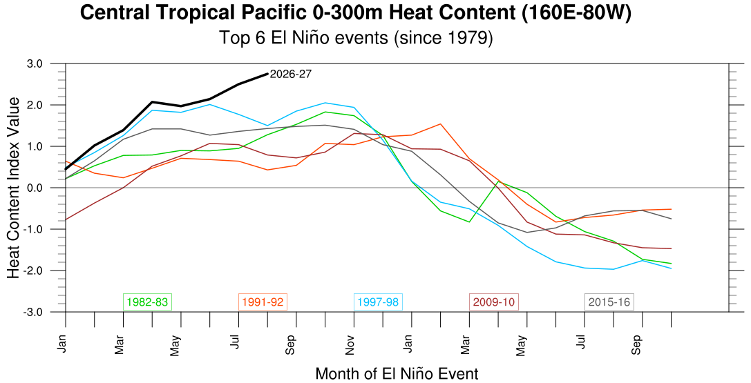
The 0-300m ocean heat content is really off the charts.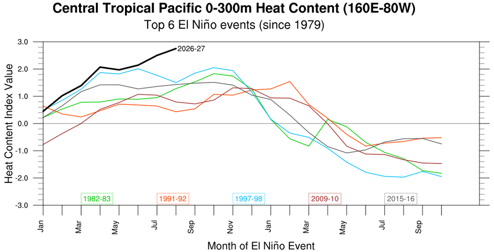
-
https://nolvacare.com/# tamoxifen for sale
-
Mike Masco THE EARLY WINTER MODEL SIGNALS ARE GETTING VERY INTERESTING... I know, I know... WAY too early! But we've reached the point in the forecast calendar where I start looking at the broader trends in the CFSv2 to see what type of atmospheric configuration the models are beginning to latch onto. This is NOT the time to start predicting snowfall totals or declaring the winter warm or cold. Instead, I'm watching three major players at the 500mb and 1000mb levels that could eventually shape how this winter unfolds: GREENLAND BLOCKING — OR LACK THEREOF Where does blocking develop, and is it focused west or east of Greenland? This is one of the biggest variables for the East Coast. A favorable blocking pattern can slow storms near the coast while helping cold Canadian air press south. This signal often isn't fully realized until we're already entering or exiting a blocking cycle, and its impact will be closely tied to the strength and behavior of the Polar Vortex. This becomes especially important from late December through mid-February. THE ALEUTIAN / NORTH PACIFIC PATTERN I'm watching whether the height field near the Aleutian Islands trends stronger or weaker. This signal should become much clearer by late November and can have major implications for how much Pacific air floods into the country. A stronger Pacific influence could overwhelm the northern half of the U.S. with milder-than-normal air — something I'll be watching VERY closely. THE SUBTROPICAL JET — THE BIG ONE So far, this has been the most compelling signal and exactly the type of feature you'd expect during an El Niño winter. You can have all the cold air in the world, but you can't get a snowstorm without moisture. A juiced-up subtropical jet could provide plenty of storm opportunities this winter. Right now, I think this is the major wildcard for producing some BIG storms, potentially favoring the Ohio Valley into western Pennsylvania, with the strongest signal across the southern U.S. The million-dollar question for the Northeast: Can the cold air meet the moisture at the right time? That's where Greenland blocking, the Polar Vortex and the Canadian pattern become incredibly important. Again — this is NOT a winter forecast. It's an early look at the atmospheric players I'm watching as the pieces slowly begin to come together. Plenty will change between now and December... but the early signals are certainly worth watching.
-
tamoxifen and uterine thickening: NolvaCare or tamoxifen 20 mg tablet
-

2026-2027 Record-breaking El Nino
MJO812 replied to Stormchaserchuck1's topic in Weather Forecasting and Discussion
Mike Masco THE EARLY WINTER MODEL SIGNALS ARE GETTING VERY INTERESTING... I know, I know... WAY too early! But we've reached the point in the forecast calendar where I start looking at the broader trends in the CFSv2 to see what type of atmospheric configuration the models are beginning to latch onto. This is NOT the time to start predicting snowfall totals or declaring the winter warm or cold. Instead, I'm watching three major players at the 500mb and 1000mb levels that could eventually shape how this winter unfolds: GREENLAND BLOCKING — OR LACK THEREOF Where does blocking develop, and is it focused west or east of Greenland? This is one of the biggest variables for the East Coast. A favorable blocking pattern can slow storms near the coast while helping cold Canadian air press south. This signal often isn't fully realized until we're already entering or exiting a blocking cycle, and its impact will be closely tied to the strength and behavior of the Polar Vortex. This becomes especially important from late December through mid-February. THE ALEUTIAN / NORTH PACIFIC PATTERN I'm watching whether the height field near the Aleutian Islands trends stronger or weaker. This signal should become much clearer by late November and can have major implications for how much Pacific air floods into the country. A stronger Pacific influence could overwhelm the northern half of the U.S. with milder-than-normal air — something I'll be watching VERY closely. THE SUBTROPICAL JET — THE BIG ONE So far, this has been the most compelling signal and exactly the type of feature you'd expect during an El Niño winter. You can have all the cold air in the world, but you can't get a snowstorm without moisture. A juiced-up subtropical jet could provide plenty of storm opportunities this winter. Right now, I think this is the major wildcard for producing some BIG storms, potentially favoring the Ohio Valley into western Pennsylvania, with the strongest signal across the southern U.S. The million-dollar question for the Northeast: Can the cold air meet the moisture at the right time? That's where Greenland blocking, the Polar Vortex and the Canadian pattern become incredibly important. Again — this is NOT a winter forecast. It's an early look at the atmospheric players I'm watching as the pieces slowly begin to come together. Plenty will change between now and December... but the early signals are certainly worth watching. -
Septorcher 2026 Discussion - Endless Summer
CoastalWx replied to Damage In Tolland's topic in New England
Warm, boredom, and stein as far as the eye can see. So much for redoing lawn this month. El Paso climate continues.