All Activity
- Past hour
-

Septorcher 2026 Discussion - Endless Summer
dendrite replied to Damage In Tolland's topic in New England
Sunday looks shot, but if we stay dry most of the week it may be mostly 60s with 40s/50s at night. It's just a lot of NE flow. -
It's early in terms of timing, but Sunday afternoon/evening appear to have the highest chance of heavier rain.
-
Look at how bad it did south of the Aleutian islands That's why seasonal models showing a -200dm +PNA this Feb I don't think will be right. The pattern hasn't been happening recently.
-

2026-2027 Fall/Winter Mountain Thread
Met1985 replied to BlueRidgeFolklore's topic in Southeastern States
Models keep on wavering from a significant cool shot to maybe a backdoor front that would mostly benefit the East. I honestly hope for just normal temps by the end of September. This never ending summer has run it's course. 84 for a high today which is stupid for here. -
 Cialis 20mg price in USA: menon36 - Buy Tadalafil 20mg
 -
I hope the rain holds off until the evening. I'm having a house warming party Sunday afternoon and there's 20 people coming. I'm hoping to be able to use the deck for an indoor/ outdoor party.
-
Cialis 20mg price in USA: menon36 - Buy Tadalafil 20mg
-

Mid-Long Range Discussion 2026
WinstonSalemArlington replied to BooneWX's topic in Southeastern States
Do you believe in the magic of the Equinox? -
Cialis 20mg price in USA: menon36 - Buy Tadalafil 20mg
-
Septorcher 2026 Discussion - Endless Summer
DavisStraight replied to Damage In Tolland's topic in New England
Mine has too, hope to thicken the lawn this fall. -
cheap viagra: GetBelvion - Generic Viagra online
-
We aren't there yet. This upcoming period is probably only marginally related to the Nino. The atmospheric response in our area will likely become more notable in another month or so. Right now its about obliterating the drought. Concern about the thermals is way out there, and we know it will be problematic.
-
Nothing at 5pm
-

2026 Atlantic Hurricane Season
WEATHER53 replied to Stormchaserchuck1's topic in Tropical Headquarters
The signal that Katrina was the sure sign of global warming causing ever increasing destruction to the USA was Gore style hype. -
I mean it is a niño, precip isn’t a problem. It’s the thermals you gotta watch come wintertime.
-

Septorcher 2026 Discussion - Endless Summer
kdxken replied to Damage In Tolland's topic in New England
Anyway we get out of this next week without it being miserable? I need some hope. - Today
-
Is the steadier/heavier rain trending later in the day? Ive seen some forecast hinting at that but others not so much. Im trying to figure how doable some outdoor events will be Sun mid morning to early afternoon
-
Septorcher 2026 Discussion - Endless Summer
kdxken replied to Damage In Tolland's topic in New England
One can hope. -

Occasional Thoughts on Climate Change
TheClimateChanger replied to donsutherland1's topic in Climate Change
Here are some conceptual examples of what this would look like with winter temperatures: -

2026-2027 Record-breaking El Nino
mitchnick replied to Stormchaserchuck1's topic in Weather Forecasting and Discussion
Cfs2 has a seperate link for the coming month. https://www.cpc.ncep.noaa.gov/products/CFSv2/monthly/ -

Central PA Summer 2026 Discussion/Obs Thread
Mount Joy Snowman replied to Voyager's topic in Upstate New York/Pennsylvania
Congrats that’s a big moment and a special time for you and her. I graduated in 2004 and have been a season ticket holder ever since. Have a great time! -

2026-2027 Record-breaking El Nino
GaWx replied to Stormchaserchuck1's topic in Weather Forecasting and Discussion
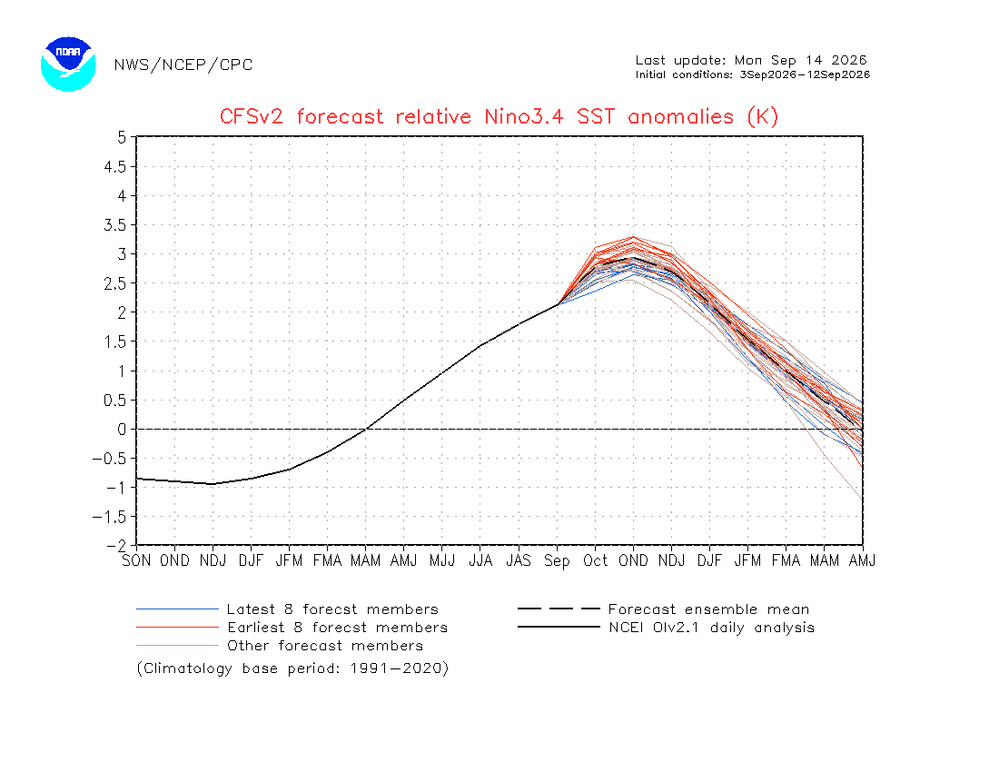
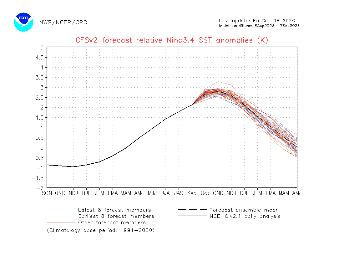
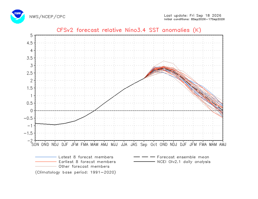
Follow-up: I emailed the 2 contacts who are listed at this CFSv2 site. Just minutes later, the site was updated! Here’s the brand new latest 10 day mean RONI forecast: as expected, the progged peak dropped even further to +2.8. Compare that to the +3.5 runs of late July. It appears it could even drop to +2.75 later this month based on the red vs blue lines: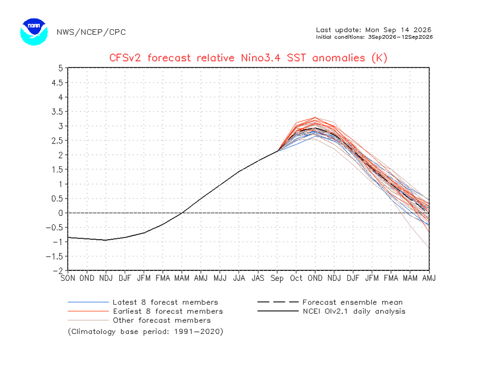
-
Scorching high of 94 after a low of 69. Hopefully we won't see anymore mid 90's.
-
Cheap generic Viagra online: GetBelvion - Cheapest Sildenafil online
-
Cooler air will return for the weekend. Saturday will be a dry day with partly sunny skies. Clouds will increase on Sunday. Highw will be in the upper 60s to around 70°. A rainy period will likely develop late Sunday. Periods of rain could continue into at least the middle of next week. Temperatures will remain unseasonably cool throughout next week. The ENSO Region 1+2 anomaly was +4.5°C and the Region 3.4 anomaly was +2.9°C for the week centered around September 9. For the past six weeks, the ENSO Region 1+2 anomaly has averaged +4.23°C and the ENSO Region 3.4 anomaly has averaged +2.65°C. The ongoing strong El Niño, will continue to strengthen through the mid-fall. The SOI was -34.52 today. The preliminary Arctic Oscillation (AO) was +2.661 today. Based on sensitivity analysis applied to the latest guidance, there is an implied near 63% probability that New York City will have a cooler than normal September (1991-2020 normal). September will likely finish with a mean temperature near 68.5° (0.7° below normal). Supplemental Information: The projected mean would be 0.5° above the 1981-2010 normal monthly value.